
Church Stretton is a market town in Shropshire, England, 13 miles (21 km) south of Shrewsbury and 15 miles (24 km) north of Ludlow. The population in 2011 was 4,671.

Bishop's Castle is a market town in the south west of Shropshire, England. According to the 2011 Census it had a population of 1,893.

Pontesbury is a village and civil parish in Shropshire and is approximately eight miles southwest of Shrewsbury. In the 2011 census, the village had a population of 1,873 and the parish had a population of 3,227. The village of Minsterley is just over a mile further southwest. The A488 road runs through the village, on its way from Shrewsbury to Bishop's Castle. The Rea Brook flows close by to the north with the village itself nestling on the northern edge of the Shropshire Hills AONB. Shropshire County Council in their current Place Plan detail the development strategy and refer to Pontesbury and neighbouring Minsterley as towns.

Minsterley is a village and civil parish in Shropshire, England. In the 2011 census, its population was 1,777. Minsterley lies one mile south-west of Pontesbury and 10 miles south-west of Shrewsbury. East from Minsterley along the A488, is the larger village of Pontesbury and to its south the hill range, the Stiperstones. The Rea Brook flows nearby and the smaller Minsterley Brook flows through the centre of the village.

Westbury is a village and parish in Shropshire, England. It includes the settlements of Caus Forest, Lake, Marche, Newtown, Stoney Stretton, Vennington, Wallop, Westbury, Whitton, Winsley and Yockleton. It lies 8 miles (13 km) west of the town of Shrewsbury, very close to the Wales-England border. It is located at 135 m altitude. It had a population of 1,352 according to the 2011 census. In 2005, Westbury parish expanded with the annexation of half of the former Wollaston parish.

The English county of Shropshire has a fairly large railway network, with 19 National Rail stations on various national lines; there are also a small number of heritage and freight lines, including the famous heritage Severn Valley Railway running along its eastern border with Worcestershire.

Dorrington is a large village in Shropshire, England, it is located 6 miles (9.7 km) south of Shrewsbury. The population of the village was estimated as being 619 in 2008.

The Minsterley branch was a short railway line that ran from Cruckmeole Junction on the Cambrian Line just south of Shrewsbury to Minsterley in Shropshire. The six-and-a-half mile standard gauge line was the only section built of a plan to connect Shrewsbury with mid Wales. It was part of a joint venture between the Great Western Railway and London and North Western Railway companies.

Church Stretton railway station in Church Stretton, Shropshire, England, is a station on the Welsh Marches Line, 12+3⁄4 miles (20.5 km) south of Shrewsbury railway station; trains on the Heart of Wales Line also serve the station. All trains services are operated by Transport for Wales, who also manage the station.
Jolly Bus was an English bus company operating in Sunderland from 1923 until 1995.

Malehurst is a hamlet in Shropshire, England between the large villages of Pontesbury and Minsterley and north of the small village of Asterley. It is within the civil parish of Pontesbury.
The Bishop's Castle Railway was a railway company that constructed a railway line in Shropshire, from near Craven Arms to Bishop's Castle. It opened in 1866 but was continuously short of money, and was unable to complete its originally-planned route, nor to provide more than the most basic level of equipment. It closed due to bankruptcy in 1935.
Minsterley Brook is a small stream in Shropshire, England.
The Shrewsbury and Welshpool Railway (S&WR) is a standard gauge railway which connects the towns of Shrewsbury and Welshpool. It opened in 1861 and the majority of the railway continues in use.

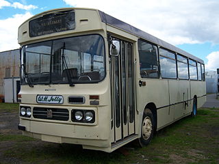
Minsterley Motors is a family owned and run bus and coach operator in Shropshire, England.
National Cycle Network Route 44, part of the National Cycle Network, connects Shrewsbury, Shropshire with Cinderford, Gloucestershire. The part of the route from Shrewsbury to Bromfield is signed - the remainder of the route is currently unsigned.
Great Ryton is a small village in Shropshire, England, to the south of Shrewsbury.
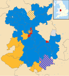
Elections to Shropshire Council were held on 2 May 2013 as part of the 2013 United Kingdom local elections. These were the second elections to the unitary authority created as part of local government restructuring in Shropshire, following on from the previous elections in 2009. All 74 seats in the 63 electoral divisions were up for election across Shropshire. At the same time, all town and parish council contested elections took place, most notably including Shrewsbury Town Council.
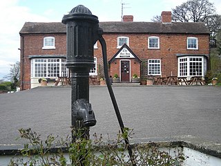
Minsterley is a civil parish in Shropshire, England. It contains 24 listed buildings that are recorded in the National Heritage List for England. Of these, two are at Grade II*, the middle of the three grades, and the others are at Grade II, the lowest grade. The parish contains the village of Minsterley and the surrounding countryside. Most of the listed buildings are houses, cottages, farmhouses and farm buildings, almost all those dating before the end of the 17th century being timber framed. The other listed buildings are a church, a group of tombs in the churchyard, a former toll house, a former watermill, a former malthouse, a milestone, a pump, a urinal, and a bridge.

Shrewsbury bus station is a large bus station and terminus located on Raven Meadows in the centre of Shrewsbury, the county town of Shropshire, England.
