Harvard Square Subway Kiosk

Last updated

Harvard Square Subway Kiosk
Harvard Square Subway Kiosk from the southeast, November 2020.jpg
Harvard Square Subway Kiosk in November 2020
USA Massachusetts location map.svg
Red pog.svg
Location0 Harvard Square
Cambridge, Massachusetts
Coordinates 42°22′25″N71°07′08″W / 42.37358°N 71.11896°W / 42.37358; -71.11896 Coordinates: 42°22′25″N71°07′08″W / 42.37358°N 71.11896°W / 42.37358; -71.11896
AreaInterior: ~500 square feet (46 m2) [1]
Roof: ~1,350 square feet (125 m2) [2] :3
BuiltNovember 1927–January 1928 [2] :11
Architect Blackall, Clapp & Whittemore [2] :17
NRHP reference No. 78000441 [3]
Added to NRHPJanuary 30, 1978 [3]

The Harvard Square Subway Kiosk is a historic kiosk and landmark located in Harvard Square in Cambridge, Massachusetts. It was built in 1928 as the new main headhouse (entrance building) for the previously-opened Harvard Square subway station. After the station closed in 1981 for major renovations, the kiosk was moved slightly and renovated. The Out of Town News newsstand, which opened in 1955, occupied the kiosk from 1984 to 2019. As of 2019, the City of Cambridge (which owns the structure) plans to convert it for public use.

Contents

History

Subway entrance

The original 1912-built headhouse, which was demolished in 1927 Harvard station headhouse, 1910s.jpg
The original 1912-built headhouse, which was demolished in 1927
A 1930s postcard of Harvard Square with the headhouse at center foreground Tichnor Brothers Harvard Square postcard, circa 1930s.jpg
A 1930s postcard of Harvard Square with the headhouse at center foreground

After debate about running an elevated rapid transit line above business districts in Cambridge, the Boston Elevated Railway (BERy) agreed in late 1906 to build a subway line from Boston to Harvard Square. [4] :7 Construction began on May 24, 1909. [4] :7 The Cambridge subway opened from Harvard Square to Park Street Under on March 23, 1912. [5] Early plans called for an upright stone entrance (headhouse) in the center of Harvard Square, similar to those at Scollay Square and Adams Square. The headhouse was ultimately constructed as a 40-by-60-foot (12 m × 18 m) oval-shaped brick-and-stone structure, with several smaller entrances and exits around the square. [6] [4] :20,31

Although originally considered a worthy addition to the Square, the headhouse attracted criticism beginning in 1919. Its size meant that motorists could not see traffic approaching on other streets, and it left no room for sidewalks where passengers could wait for streetcars. [2] :10 In 1921, the Massachusetts Department of Public Utilities (DPU) determined that it would not be feasible to completely replace the central headhouse with smaller headhouses located elsewhere in the Square. The DPU was not opposed to Cambridge constructing a smaller headhouse structure, but would not allow the state or the BERy to bear the costs. [2] :10

MIT civil engineering professor Charles B. Breed completed a study of the headhouse in February 1925, concluding that the headhouse could be reduced to 20% of its original size at a cost of $20,000 (equivalent to $239,000in 2020 [7] ). Breed proposed to have the 17-by-25-foot (5.2 m × 7.6 m) structure cover only the exit escalator and one of the two stairwells; the remaining stairwell would be covered with a hatch and only used on high-demand days. [8] [2] :10 On April 30, 1925, the state legislature authorized the DPU to modify the headhouse at a cost up to $30,000. Cambridge was to pay half the cost; the state would loan the BERy the remaining half. [2] :10 [9]

That July, the DPU viewed models of Breed's proposal, as well as a larger proposal by the BERy that kept both stairwells. Public reaction to Breed's utilitarian design was "swift and overwhelmingly negative"; one state representative likened it to an outhouse. [2] :11 In November 1925, architect Clarence H. Blackall began advising the DPU on the headhouse design. Blackhall's design was eventually approved by the Cambridge City Council in February 1927, and the BERy began engineering work that February. [2] :11 The DPU awarded a $15,950 construction contraction on October 21, 1927; work began in November and was completed in January 1928. [2] :11 Despite his previous prominence as an architect, the contribution of Blackhall's firm (Blackall, Clapp & Whittemore) was largely ignored in the press. [2] :11 [10]

The new headhouse measured 15+12 by 36 feet (4.7 m × 11.0 m), covered by a roof measuring about 30 by 44 feet (9.1 m × 13.4 m). It was divided into two pavilions: the 15+12-by-12-foot (4.7 m × 3.7 m) south section around the exit stairwell and the 15+12-by-15-foot (4.7 m × 4.6 m) north section around the entrance stairwell, with an exit escalator and a pedestrian passage between them. [2] :18 [11] The structure was of industrial style, though it fit in with the Colonial Revival architecture of Harvard Square. [12] [11] [2] :12 The pavilions were each supported by steel pillars clad in limestone and brick salvaged from the old headhouse. Three sides of each had low walls, with wire glass above to allow visibility through the structure for motorists. The thin copper roof was shaped as intersecting barrel vaults, with flat rectangles at the corners. [2] :11,17 The "artistic appearance" of the new structure was favorably compared to the former "pillbox". [10] [2] :14

At some point within the next decade, internally-illuminated signs reading "HARVARD SQUARE" were added inside the arches. Rooftop signs reading "Rapid Transit to All Points/Eight Minutes to Park Street" were added in the 1940s. [2] :15,20 The city again considered relocating the headhouse in 1944, but found the $1 million (equivalent to $12 million in 2020 [7] ) cost too high. [2] :14 In 1962, the MTA (successor to the BERy) proposed to relocate the station southward into Bennett Yard, with the kiosk and buses removed from the Square. [2] :14–15 However, by this time, the kiosk was beginning to be recognized as a significant symbol of the Square; in the mid-1960s, architecture critic Ian Nairn called it "an urban epigram in a tiny space... probably the most important space in Harvard." [2] :15

The 1964-formed Massachusetts Bay Transportation Authority (MBTA) renamed the Harvard–Ashmont subway line as the Red Line in 1967. [5] Among the MBTA's expansion projects was a long-proposed northwest extension of the Red Line. Several alignments near Harvard Square were considered; by 1977, the MBTA planned to reroute the line northwards through the Square itself. The wholly reconfigured station would have three smaller headhouses around the Square. [13] That year, the Cambridge Historical Commission nominated the headhouse for the National Register of Historic Places (NRHP) - a designation which requires mitigation of any adverse effects by federally- or state-funded projects. It was added to the NRHP on January 30, 1978 as "Harvard Square Subway Kiosk". [3] [2] :5

In August 1977, the MBTA agreed to preserve the structure by dismantling it during construction, then reassembling it for reuse as a newsstand. [2] :5 By 1978, the MBTA planned for the restored kiosk to occupy its original location, with a single new headhouse to the south. [2] :20 Harvard station closed for reconstruction on January 31, 1981. [5] The headhouse was disassembled that February; the copper roof and the brick and limestone of the pillars were placed in storage. [2] :17 The kiosk was included in the Harvard Square Historic District in its 1982 NRHP addition, though it also retained its separation registration. [2] :5 In 1983, ownership of the disassembled kiosk was passed to the City of Cambridge. [2] :4

Out of Town News

Circa-1970s postcard of Harvard Square, showing Out of Town News in its former location (dark roof) next to the subway entrance kiosk Harvard Square circa 1970s postcard.jpg
Circa-1970s postcard of Harvard Square, showing Out of Town News in its former location (dark roof) next to the subway entrance kiosk
Out of Town News in 2006 2006 newsstand Cambridge Massachusetts USA 150445218.jpg
Out of Town News in 2006

Out of Town News was founded in 1955 by Sheldon Cohen. [14] Cohen operated several other businesses around the square, and was known as the “unofficial mayor of Harvard Square". [15] Originally located just north of the subway headhouse, the newsstand was long noted for stocking leading newspapers, magazines, and periodicals from around the nation and around the world – many of which were flown to Boston to be available just one day after printing. Customers, especially academics, came to get the most recent editions of their hometown paper or of newspapers from parts of the world where important news events were unfolding. [16]

The newsstand also became famous for its regular clientele and visitors. John Kenneth Galbraith and Julia Child were both regular customers, and Robert Frost once asked for directions at the stand on the way to a poetry reading. [14] Paul Allen, then a young programmer at Honeywell, bought the January 1975 issue of Popular Electronics at Out of Town News. The magazine inspired Allen and his friend Bill Gates to found Microsoft that April. [17]

In 1984, Out of Town News moved into the former subway kiosk structure, which had been relocated a few feet north of its original location on June 8. [14] [18] In 1994, Cohen sold Out of Town News to Hudson News, although it kept its name and unique business model. [14] Responding to the 1994 sale, a citizen group submitted a petition to landmark the kiosk, but the Cambridge Historical Committee decided that the lease restrictions on the kiosk were sufficient protections. [19]

In 2008, it was announced that the newsstand might go out of business, principally because its unique function of supplying yesterday's newspapers was made obsolete by the ability to read them online. [20] By then, the physical structure also required hundreds of thousands of dollars for repairs. [14] In January 2009, a new owner, Muckey's Corporation, won a bidding competition and signed a lease to take over the newsstand. [21] Muckey's diversified the stand's offering with more typical magazines and convenience store fare, but maintained the original name. [22]

In 2013, the city began studying use and possible renovation of Harvard Square, including possibly further restoration or reworking of the kiosk. When the long-term lease expired in January 2016, the city signed a month-to-month lease ending in July 2017, while exploring its options for the space. [1] In August 2016, the city announced plans to convert the structure to a glass-walled public space, despite the lessee's offer to contribute to the renovations if the business could stay. [23]

In September 2016, a citizen group again petitioned the Cambridge Historical Commission to designate the kiosk as a protected landmark, which would effectively stop the proposed major renovation. [19] In November 2016, the Cambridge Historical Commission voted in support of proceeding with a landmark study.

Out of Town News closed on October 31, 2019. Temporary artwork was placed in the kiosk until renovation began. [24] As of April 2022, renovation of the structure for a visitors center is expected to be complete in April 2023. [25]

See also

Related Research Articles

Red Line (MBTA) Greater Boston subway line

The Red Line is a rapid transit line operated by the Massachusetts Bay Transportation Authority (MBTA) as part of the MBTA subway system. The line runs south and east underground from Alewife station in North Cambridge through Somerville and Cambridge, surfacing to cross the Longfellow Bridge then returning to tunnels under Downtown Boston. It continues underground through South Boston, splitting into two branches on the surface at JFK/UMass station. The Ashmont branch runs southwest through Dorchester to Ashmont station, where the connecting light rail Ashmont–Mattapan High Speed Line continues to Mattapan station. The Braintree branch runs southwest through Quincy and Braintree to Braintree station.

Harvard Square United States historic place

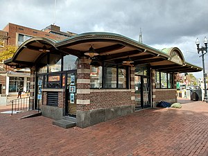
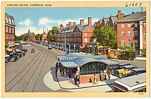
Harvard Square is a triangular plaza at the intersection of Massachusetts Avenue, Brattle Street, and John F. Kennedy Street, near the center of Cambridge, Massachusetts, United States. The term "Harvard Square" is also used to delineate the business district and Harvard University surrounding that intersection, which is the historic center of Cambridge. Adjacent to Harvard Yard, the historic heart of Harvard University, the Square functions as a commercial center for Harvard students, as well as residents of western Cambridge and the western and northern neighborhoods and inner suburbs of Boston. The Square is served by Harvard station, a major MBTA Red Line subway and bus transportation hub.

Park Street station (MBTA) Subway station in Boston, Massachusetts, US

Park Street station is an MBTA subway station in Boston, Massachusetts. It is located at the intersection of Park Street and Tremont Street at the eastern edge of Boston Common in Downtown Boston. One of the two oldest stations on the "T", Park Street is the transfer point between the Green and Red Lines, as one of the quartet of "hub stations" on the MBTA subway system. Park Street is the fifth-busiest station in the MBTA network, with an average of 16,571 entries each weekday in FY2019.

Alewife station Rapid transit station in Cambridge, Massachusetts

Alewife station is a Massachusetts Bay Transportation Authority (MBTA) intermodal transit station in the North Cambridge neighborhood of Cambridge, Massachusetts. It is the northwest terminal of the rapid transit Red Line and a hub for several MBTA bus routes. The station is at the confluence of the Minuteman Bikeway, Alewife Linear Park, Fitchburg Cutoff Path, and Alewife Greenway off Alewife Brook Parkway adjacent to Massachusetts Route 2, with a five-story parking garage for park and ride use. The station has three bike cages. Alewife station is named after nearby Alewife Brook Parkway and Alewife Brook, themselves named after the alewife fish.

Harvard station MBTA subway station in Harvard Square, Cambridge

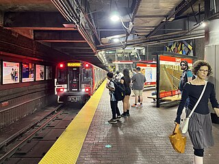
Harvard station is a rapid transit and bus transfer station in Cambridge, Massachusetts. Located at Harvard Square, it serves the MBTA's Red Line subway system as well as MBTA buses. Harvard averaged 18,528 entries each weekday in FY2019, making it the third-busiest MBTA station after Downtown Crossing and South Station. Five of the fifteen key MBTA bus routes stop at the station.

Porter station Transit station in Cambridge, Massachusetts

Porter is a Massachusetts Bay Transportation Authority (MBTA) transit station in Cambridge, Massachusetts. It serves the Red Line rapid transit line, the MBTA Commuter Rail Fitchburg Line, and several MBTA bus lines. Located at Porter Square at the intersection of Massachusetts and Somerville Avenues, the station provides rapid transit access to northern Cambridge and the western portions of Somerville. Porter is 14 minutes from Park Street on the Red Line, and about 10 minutes from North Station on commuter rail trains. Several local MBTA bus routes also stop at the station.

Davis station (MBTA) Rapid transit station in Somerville, Massachusetts, US

Davis station is an underground Massachusetts Bay Transportation Authority (MBTA) Red Line rapid transit station located at Davis Square in Somerville, Massachusetts. The accessible station has a single island platform for the Red Line, as well as a dedicated busway on the surface. It opened in 1984 as part of the Red Line Northwest Extension project.

Kendall/MIT station Subway station in Cambridge, Massachusetts

Kendall/MIT station is an underground rapid transit station in Cambridge, Massachusetts. It serves the MBTA Red Line, Located at the intersection of Main Street and Broadway, it is named for the primary areas it serves - the Kendall Square business district and the Massachusetts Institute of Technology (MIT). Opened in March 1912 as part of the original Cambridge subway, Kendall/MIT has two side platforms serving the line's two tracks. The Kendall Band, a public art installation of hand-operated musical sculptures, is located between the tracks in the station with controls located on the platforms. Kendall/MIT station is accessible. With 17,018 weekday boardings by a FY2019 count, Kendall/MIT has the fourth highest ridership among MBTA subway stations.

Charles/MGH station Boston, Massachusetts subway station

Charles/MGH station is a rapid transit station on the MBTA Red Line, elevated above Charles Circle on the east end of the Longfellow Bridge in the West End neighborhood of Boston, Massachusetts. The station is named for Charles Circle and the adjacent Massachusetts General Hospital (MGH) campus. It has two side platforms, with a glass-walled headhouse structure inside Charles Circle. Charles/MGH station is fully accessible.

Government Center station (MBTA) Subway station in Boston, Massachusetts

Government Center station is an MBTA subway station in Boston, Massachusetts. It is located at the intersection of Tremont, Court and Cambridge Streets in the Government Center area. It is a transfer point between the light rail Green Line and the rapid transit Blue Line. With the Green Line platform having opened in 1898, the station is the third-oldest operating subway station in the MBTA system; only Park Street and Boylston are older. The station previously served Scollay Square before its demolition for the creation of Boston City Hall Plaza.

State station Boston MBTA subway station

State station is a subway station in Boston, Massachusetts. Located in downtown Boston, State is the transfer point between the MBTA Orange Line and the Blue Line, and one of four "hub stations" on the MBTA subway system.

Aquarium station (MBTA) Subway station in Boston, Massachusetts

Aquarium station is an underground rapid transit station on the MBTA Blue Line in Boston, Massachusetts, United States. It is located under State Street at Atlantic Avenue on the eastern edge of Boston's Financial District near Boston Harbor. The station is named for the nearby New England Aquarium. It is adjacent to Long Wharf, which is used by two MBTA Boat lines. The station has two side platforms serving the two tracks of the Blue Line; an arched ceiling runs the length of the platform level. With the platforms 50 feet (15 m) below street level, it is the second-deepest station on the MBTA system.

Lechmere station Light rail station in Cambridge, Massachusetts

Lechmere station is a Massachusetts Bay Transportation Authority (MBTA) Green Line light rail station in Lechmere Square in East Cambridge, Massachusetts. It is located on the east side of Monsignor O'Brien Highway near First Street, adjacent to the NorthPoint development. The accessible elevated station has a single island platform, with headhouses at both ends. It opened on March 21, 2022, as part of the Green Line Extension (GLX). Lechmere station will initially be served by the Green Line E branch service; D branch service will be added later in 2022.

Hynes Convention Center station Boston, Massachusetts light rail station

Hynes Convention Center station is an underground light rail station on the Massachusetts Bay Transportation Authority (MBTA) Green Line. It is located at the intersection of Newbury Street and Massachusetts Avenue near the western end of the Back Bay neighborhood of Boston, Massachusetts. The station is named for the Hynes Convention Center, which is located about 700 feet (210 m) to the east along Boylston Street. It has two side platforms serving the two tracks of the Boylston Street subway, which are used by the Green Line B branch, C branch, and D branch. The main entrance to the station from Massachusetts Avenue leads to a fare lobby under the 360 Newbury Street building.

Green Line B branch Light rail line in Boston, Massachusetts

The B branch, also called the Commonwealth Avenue branch or Boston College branch, is a branch of the MBTA Green Line light rail system which operates on Commonwealth Avenue west of downtown Boston, Massachusetts. One of four branches of the Green Line, the B branch runs from Boston College station down the median of Commonwealth Avenue to Blandford Street. There, it enters Blandford Street portal into Kenmore station, where it merges with the C and D branches. The combined services run into the Boylston Street subway and Tremont Street subway to downtown Boston. B branch service has terminated at Government Center since October 2021. Unlike the other branches, the B branch runs solely through the city limits of Boston. The Green Line Rivalry between Boston College and Boston University is named in reference to the B branch, which runs to both universities.

Bowdoin station MBTA subway station

Bowdoin station is a Massachusetts Bay Transportation Authority (MBTA) rapid transit station in Bowdoin Square in Boston, Massachusetts. The station is the downtown terminus of the Blue Line, part of the MBTA subway system. It has a single wedge-shaped island platform located inside a balloon loop. Bowdoin is the only Blue Line station that is not accessible.

Tremont Street subway Boston subway tunnel

The Tremont Street subway in Boston's MBTA subway system is the oldest subway tunnel in North America and the third oldest still in use worldwide to exclusively use electric traction, opening on September 1, 1897. It was originally built, under the supervision of Howard A. Carson as chief engineer, to get streetcar lines off the traffic-clogged streets, instead of as a true rapid transit line. It now forms the central part of the Green Line, connecting Boylston Street to Park Street and Government Center stations.

Copley station MBTA subway station

Copley station is an underground light rail station on the MBTA Green Line, located in the Back Bay section of Boston, Massachusetts. Located in and named after Copley Square, the station has entrances and exits along Boylston Street and Dartmouth Street.

Chinatown station (MBTA) MBTA subway station

Chinatown is a rapid transit station on the Massachusetts Bay Transportation Authority (MBTA) Orange Line, located at the edge of the Chinatown neighborhood in downtown Boston. The station has two offset side platforms, which run under Washington Street from Hayward Place to Lagrange Street. The three entrances are located at the intersection of Washington Street with Essex and Boylston streets. Like all Orange Line stations, both the subway platforms and all bus connections are fully accessible.

Conductors Building Former Boston railway administration building

The Conductor's Building is a former Boston Elevated Railway (BERy) administrative building, located on Bennett Alley between Mount Auburn Street and Bennett Street near Harvard Square in Cambridge, Massachusetts. Built in 1912 as the headquarters of BERy's 7th Division, it is the only original building surviving from the construction of the Cambridge subway. After being renovated from 2014 to 2017 as part of an adjacent hotel project, the building was used as a restaurant from April 2017 to August 2018. Under the name Boston Elevated R.Y. Offices, it is a contributing property to the Harvard Square Historic District.

References

  1. 1 2 Feijo, Sara (July 9, 2015). "Big plans for Out of Town News in Harvard Square". Wicked Local Cambridge. Retrieved September 8, 2015.
  2. 1 2 3 4 5 6 7 8 9 10 11 12 13 14 15 16 17 18 19 20 21 22 23 24 25 Sullivan, Charles (November 30, 2017). "Final Landmark Designation Report: Harvard Square Kiosk". Cambridge Historical Commission.
  3. 1 2 3 "National Register Information System  Harvard Square Subway Kiosk (#78000441)". National Register of Historic Places. National Park Service. November 2, 2013.
  4. 1 2 3 Cheney, Frank (2002). Boston's Red Line: Bridging the Charles from Alewife to Braintree. Arcadia Publishing. ISBN   9780738510477.
  5. 1 2 3 Belcher, Jonathan. "Changes to Transit Service in the MBTA district" (PDF). Boston Street Railway Association.
  6. "The Cambridge Subway". Electric Railway Journal . Vol. 39, no. 19. May 11, 1912. pp. 782–789 via Google Books.
  7. 1 2 Johnston, Louis; Williamson, Samuel H. (2022). "What Was the U.S. GDP Then?". MeasuringWorth. Retrieved February 12, 2022. United States Gross Domestic Product deflator figures follow the Measuring Worth series.
  8. "Suggests changes at Harvard Square". Boston Globe. March 19, 1925. p. 2 via Newspapers.com. Open Access logo PLoS transparent.svg
  9. Secretary of the Commonwealth (1917). "Chapter 321: An Act Providing For the Alteration of the Surface Structure of the Harvard Square Station of the Cambridge Subway". Acts and Resolves Passed by the General Court of Massachusetts in the Year 1925. Wright and Potter. pp. 373–374 via Internet Archive.
  10. 1 2 "New Harvard-Sq Station Alleviates Traffic Peril". Boston Daily Globe. February 12, 1928. p. A16. ProQuest   747453624.
  11. 1 2 Mallory, Blaine; Orfant, Joseph; Crump, Allison (June 13, 1977). "NATIONAL REGISTER OF HISTORIC PLACES INVENTORY - NOMINATION FORM: Harvard Square Subway Kiosk". National Park Service via National Archives and Records Administration.
  12. "NORTHEAST JOURNAL; OWNING A PIECE OF HARVARD SQUARE". New York Times. December 15, 1985. Retrieved November 2, 2016.
  13. Final Environmental Impact Statement: Red Line Extension - Harvard Square to Arlington Heights. Vol. 1. Urban Mass Transportation Administration. Exhibits H, L via Internet Archive.
  14. 1 2 3 4 5 Levenson, Michael (November 20, 2008). "Plan to shutter newsstand pierces heart of Harvard Sq". Boston Globe. Retrieved September 8, 2015.
  15. Flynn, Kerry M. (January 11, 2012). "Out of Town News Founder Sheldon Cohen Honored in Retirement". The Crimson. Retrieved September 8, 2015.
  16. Noah, Timothy (October 5, 1999). "Saving Out-of-Town News". Slate . Retrieved September 7, 2015.
  17. Finucane, Martin (December 30, 2008). "Harvard Square newsstand sold the magazine that started a revolution". Boston Globe. Archived from the original on January 1, 2009.
  18. "Appendix IV". 1984 Annual Report. Massachusetts Bay Transportation Authority. 1984.
  19. 1 2 "Protected Landmark Petition: Harvard Square Subway Kiosk" (PDF). Our Harvard Square. September 27, 2016.
  20. Howland, Sarah J. (November 19, 2008). "Facing Lease Problems, Newsstand May Soon Close". Harvard Crimson. Retrieved July 23, 2011.
  21. Nierstedt, Jenna (January 29, 2009). "Good news! Corporation rescues Out of Town stand". Archived from the original on January 31, 2009.
  22. Hansen, Amy (October 12, 2012). "Out of Town newstand in Harvard Square adjusts to the digital age". Boston Globe. Retrieved September 8, 2015.
  23. Conti, Katheleen (August 26, 2016). "Harvard Square could lose iconic Out of Town News". Boston Globe. Retrieved August 26, 2016.
  24. Vaughn, Alyssa (September 9, 2019). "Out of Town News, a Harvard Square Fixture for 60 Years, Is Closing". Boston . Retrieved September 17, 2019.
  25. "The Cambridge Office for Tourism Announces the Reopening of the Cambridge Visitor Information Center" (Press release). Harvard Square Business Association. April 6, 2022.