
Lamar County is a county located in the U.S. state of Mississippi. As of the 2020 census, the population was 64,222. Its county seat is Purvis. Named for Confederate Lucius Quintus Cincinnatus Lamar, the county was carved out of Marion County to the west in 1904.

Forrest County is located in the U.S. state of Mississippi. As of the 2020 census, the population was 78,158. Its county seat and largest city is Hattiesburg. The county was created from Perry County in 1908 and named in honor of Nathan Bedford Forrest, a Confederate general in the American Civil War and the first Grand Wizard of the Ku Klux Klan. Forrest County is part of the Hattiesburg, MS Metropolitan Statistical Area.

Ellisville is a town in and the first county seat of Jones County, Mississippi, United States. The population was 4,448 at the time of the 2010 census, up from 3,465 at the 2000 census. The Jones County Courthouse is located here, as is much of the county government.

New Augusta is a town in Perry County, Mississippi. It is part of the Hattiesburg, Mississippi Metropolitan Statistical Area. The population was 644 at the 2010 census. It is the county seat of Perry County. New Augusta is located about two miles south of "Old" Augusta, which was the county seat until 1906.

Lumberton is a city in Lamar and Pearl River counties, Mississippi, United States. It is part of the Hattiesburg, Mississippi Metropolitan Statistical Area. The population was 2,086 at the 2010 census.
The Lima–Van Wert–Wapakoneta Combined Statistical Area (CSA) is made up of three counties in Northwest Ohio. The Lima Metropolitan Statistical Area and two Micropolitan Statistical Areas – Van Wert and Wapakoneta, are components of the CSA. As of the 2000 Census, the CSA had a population of 184,743.

The Hattiesburg Metropolitan Statistical Area is a metropolitan statistical area (MSA) in southeastern Mississippi that covers three counties - Forrest, Lamar, and Perry. The MSA's principal city is Hattiesburg. The 2010 census placed the Hattiesburg MSA's population at 162,410, though estimates as of 2019 indicate the population has increased to 168,849. The area is part of the geographical region known as the Pine Belt, famous for its abundance of longleaf pine trees. The Hattiesburg MSA is part of the larger Hattiesburg-Laurel Combined Statistical Area.
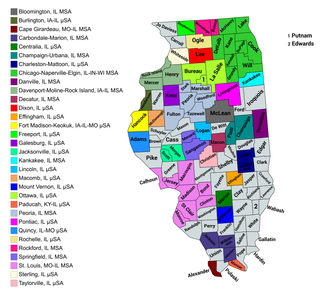
The U.S. State of Illinois currently has 43 statistical areas that have been delineated by the Office of Management and Budget (OMB). On March 6, 2020, the OMB delineated 11 combined statistical areas, 13 metropolitan statistical areas, and 19 micropolitan statistical areas in Illinois.
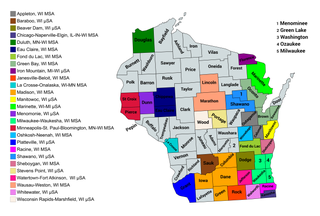
The U.S. State of Wisconsin currently has 36 statistical areas that have been delineated by the Office of Management and Budget (OMB). On March 6, 2020, the OMB delineated nine combined statistical areas, 15 metropolitan statistical areas, and 12 micropolitan statistical areas in Wisconsin.

The U.S. State of Mississippi currently has 30 statistical areas that have been delineated by the Office of Management and Budget (OMB). On March 6, 2020, the OMB delineated seven combined statistical areas, four metropolitan statistical areas, and 19 micropolitan statistical areas in Mississippi.
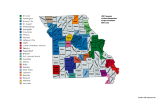
The U.S. State of Missouri currently has 31 statistical areas that have been delineated by the Office of Management and Budget (OMB). On March 6, 2020, the OMB delineated six combined statistical areas, seven metropolitan statistical areas, and 18 micropolitan statistical areas in Missouri.

The U.S. State of Louisiana currently has 25 statistical areas that have been delineated by the Office of Management and Budget (OMB). On July 21, 2023, the OMB delineated six combined statistical areas, ten metropolitan statistical areas, and nine micropolitan statistical areas in Louisiana.

The Morgantown Metropolitan Statistical Area, as defined by the United States Census Bureau, is an area consisting of two counties in North-Central West Virginia, anchored by the city of Morgantown. As of the 2020 census, the MSA had a population of 140,038.
The Salisbury, MD-DE Metropolitan Statistical Area is a United States Census Bureau-designated metropolitan area centered in and around Salisbury, Maryland, including four counties: Somerset, Wicomico, and Worcester in Maryland; and Sussex in Delaware.

The Idaho Falls Metropolitan Statistical Area, as defined by the United States Census Bureau, is an area consisting of two counties in eastern Idaho, anchored by the city of Idaho Falls. As of the 2020 census, the MSA had a population of 154,855. It is just north of the Pocatello, Idaho Metropolitan Area.

The Montgomery, Alabama Metropolitan Statistical Area is a metropolitan area in central Alabama. As of 2020, the MSA had a population of 386,047, ranking it 142nd among United States Metropolitan Statistical Areas. That number is up +3.07% from the 2010 census number of 374,536. In September of 2018 the OMB formed the Montgomery-Selma-Alexander City CSA. It's made up of the 4 county Montgomery MSA and the Selma, AL and Alexander City, AL micropolitan areas. The 7 county CSA has a population of 522,873 as of the 2020 census.

The Dothan–Enterprise–Ozark Combined Statistical Area was a CSA made up of five counties in the southeastern corner of the U.S. state of Alabama. The once statistical area includes one metropolitan area and originally one micropolitan area which then was split off as two. As of the 2010 census, the CSA had a population of 245,838. Currently an updated area called the Dothan-Ozark Combined Statistical area is used instead and Enterprise micropolitan area is now split as its own statistical area.

The New Orleans–Metairie–Slidell combined statistical area is made up of nine parishes in southeastern Louisiana and one county in Mississippi. The statistical area consists of the New Orleans metropolitan statistical area (MSA), Slidell–Mandeville–Covington, LA MSA, Picayune micropolitan statistical area (μSA), and the Bogalusa μSA. As of the 2020 census estimates, the CSA had a population of 1,510,672. In 2023, the Office of Management and Budget updated the Core Based Statistical Areas, removing St. Tammany Parish from the New Orleans–Metairie MSA to create the Slidell–Mandeville–Covington MSA.

The Corbin, Kentucky Micropolitan Area Micropolitan Area is made up of four counties in the Eastern Coalfield region of Kentucky. Before 2013, the area was officially known as the Corbin–London, KY Combined Statistical Area, and consisted of the Corbin Micropolitan Statistical Area and the London Micropolitan Statistical Area. The Corbin micropolitan area consisted of Whitley County, and the London micropolitan area consisted of Laurel County.

