
Forrest County is located in the U.S. state of Mississippi. As of the 2020 census, the population was 78,158. Its county seat and largest city is Hattiesburg. The county was created from Perry County in 1908 and named in honor of Nathan Bedford Forrest, a Confederate general in the American Civil War and the first Grand Wizard of the Ku Klux Klan. Forrest County is part of the Hattiesburg, MS Metropolitan Statistical Area.

West Hattiesburg is an unincorporated area and census-designated place (CDP) in Lamar County, Mississippi, west of the city of Hattiesburg and east of the community of Oak Grove. It is part of the Hattiesburg metropolitan area. It had a decline in population from 6,305 at the 2000 census to 5,909 at the 2010 census.

The Kingsport–Bristol–Bristol metropolitan area is a metropolitan statistical area (MSA) in Northeast Tennessee and Southwest Virginia, United States, as defined by the Office of Management and Budget (OMB). It was formed in December 2003 by the merger of the Bristol, VA MSA and Kingsport–Bristol, TN–VA MSA.

The Danville Micropolitan Statistical Area is a Micropolitan Statistical Area (μSA) in Virginia as defined by the United States Office of Management and Budget (OMB). As of the 2010 census, the μSA had a population of 106,561

The Harrisonburg Metropolitan Statistical Area is a Metropolitan Statistical Area (MSA) in Virginia as defined by the United States Office of Management and Budget (OMB). As of the 2020 census, the MSA had a population of 135,571.

The Lynchburg Metropolitan Statistical Area is a United States Metropolitan Statistical Area (MSA) in the state of Virginia, as defined by the Office of Management and Budget (OMB) as of June 2003. As of the 2000 census, the MSA had a population of 228,616. In 2009 this was estimated to have risen to 247,447; as of 2016, the Lynchburg MSA was estimated to have a population of 260,320, making it the fifth-largest metro area in the state.

The Gulfport-Biloxi Metropolitan Statistical Area is a metropolitan statistical area (MSA) in the Mississippi Gulf Coast region that includes four counties – Hancock, Harrison, Jackson and Stone. The principal cities are Gulfport and Biloxi. The 2010 census placed the Gulfport-Biloxi MSA population at 388,488, though as of 2019, it was estimated to have increased to 417,665. The area was significantly impacted by Hurricane Katrina on August 29, 2005, and prior to the hurricane, had experienced steady to moderate population growth. However, growth has since rebounded, with the population steadily increasing every year throughout the 2010s.
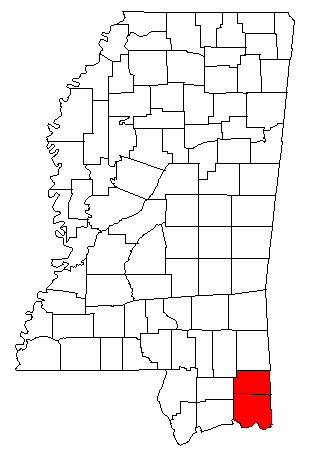
The Pascagoula Metropolitan Statistical Area was a metropolitan area in the southeastern corner of Mississippi that covered two counties - Jackson and George. As of the 2000 census, the MSA had a population of 150,564. The area was significantly impacted by Hurricane Katrina in 2005. A July 1, 2009 estimate placed the population at 155,603. Prior to the hurricane, the area had experienced steady population growth. It was also part of the larger Gulfport-Biloxi-Pascagoula Combined Statistical Area.

The Morristown Metropolitan Statistical Area, commonly known as the Lakeway Area, as defined by the United States Census Bureau, is an area consisting of three counties - Grainger, Hamblen, and Jefferson - in eastern Tennessee, anchored by the city of Morristown. Grainger County is both in the Knoxville and Morristown Metropolitans. Including Grainger County, the 2020 census showed that the MSA had a population of 142,709.

The Asheville metropolitan area is a metropolitan area centered on the principal city of Asheville, North Carolina. The U.S. Office of Management and Budget defines the Asheville, NC Metropolitan Statistical Area, a metropolitan statistical area used by the United States Census Bureau and other entities, as comprising the four counties of Buncombe, Haywood, Henderson, and Madison. The area's population was 424,858 according to the 2010 census, and 469,454 according to the 2020 census.

As defined by the U.S. Office of Management and Budget, and used by the U.S. Census Bureau for statistical purposes only, the Columbia, SC Metropolitan Statistical Area, is an area consisting of six counties in central South Carolina, anchored by the city of Columbia. The current population has an estimation of 837,092. It is the second-largest metropolitan statistical area in the state of South Carolina, since the Anderson metropolitan statistical area was combined with Greenville's following the 2010 census.

As defined by the U.S. Office of Management and Budget and used by the U.S. Census Bureau for statistical purposes only, the Florence Metropolitan Statistical Area, is an area consisting of two counties in the Pee Dee region of northeastern South Carolina, anchored by the city of Florence. As of the 2000 census, the MSA had a population of 193,155.

The New Bern Metropolitan Statistical Area, as defined by the United States Census Bureau, is an area consisting of three counties in the Inner Banks region of eastern North Carolina, anchored by the city of New Bern. The designation of the area was changed from Micropolitan to Metropolitan in 2013.

The Columbus metropolitan area, officially the Columbus metropolitan statistical area, and colloquially known as the Chattahoochee Valley, is a metropolitan statistical area consisting of six counties in the U.S. state of Georgia and one county in Alabama, anchored by the city of Columbus.

The Canton–Massillon Metropolitan Statistical Area, as defined by the United States Census Bureau, is an area consisting of two counties in Northeast Ohio, anchored by the cities of Canton and Massillon. As of the 2020 census, the MSA had a population of 401,574. The MSA is also part of the Cleveland–Akron–Canton, OH Combined Statistical Area, which had a population of 3,633,962 in 2020, making it the largest CSA in Ohio.

The New Orleans–Metairie–Slidell combined statistical area is made up of nine parishes in southeastern Louisiana and one county in Mississippi. The statistical area consists of the New Orleans metropolitan statistical area (MSA), Slidell–Mandeville–Covington, LA MSA, Picayune micropolitan statistical area (μSA), and the Bogalusa μSA. As of the 2020 census estimates, the CSA had a population of 1,510,672. In 2023, the Office of Management and Budget updated the Core Based Statistical Areas, removing St. Tammany Parish from the New Orleans–Metairie MSA to create the Slidell–Mandeville–Covington MSA.

The Macon metropolitan area is a metropolitan statistical area consisting of five counties in Central Georgia, anchored by the principal city of Macon. At the 2010 U.S. census, the five-county area had a population of 232,293. A July 2017 estimate placed the population at 228,914. In 2022, its estimated population was 235,805.

The Johnson City Metropolitan Statistical Area, as defined by the United States Census Bureau, is an area consisting of three counties in East Tennessee, anchored by the city of Johnson City. As of the 2020 census, the MSA had a population of 207,285.
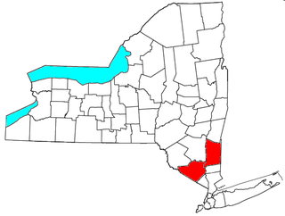
The Kiryas Joel-Poughkeepsie-Newburgh, NY Metropolitan Statistical Area, as defined by the United States Office of Management and Budget, is an area consisting of two counties in New York's Hudson Valley, with the municipalities of Kiryas Joel, Poughkeepsie, and Newburgh as its principal cities. As of the 2020 census, the MSA had a population of 679,221. The area was centered on the urban area of Poughkeepsie-Newburgh. Prior to July 2023, it was known as the Poughkeepsie-Newburgh-Middletown, NY Metropolitan Statistical Area; whereupon it was renamed to its current name, to reflect population changes among its largest municipalities.

