Hauz Khas is a neighborhood in South Delhi, its heart being the historic Hauz Khas Complex. Well known in medieval times, the Hauz Khas village has buildings built around the reservoir. There are remnants of Islamic architecture roughly colored by splotches of urban culture. It is centrally located and offers both rural Hauz Khas Village and urban Hauz Khas Enclave, Market environments. Hauz Khas is surrounded by Green Park, SDA (Sri Aurobindo Marg) to the west, Gulmohar Park (Balbir Saxena Marg) towards the north, Sarvapriya Vihar (Outer Ring Road) towards the south and Asiad Village (August Kranti Marg) and Siri Fort to the east.
Hauz Khas is also home to various diplomatic missions such as the ones of Albania, Iraq, Guinea Bissau, Burundi, and North Macedonia. Historically Hauz Khas was known as Hauz-e-Alai and is the place where Khusro Khan of Delhi Sultanate was defeated by Ghazi Malik (Governor of Dipalpur) in 1320.
Hauz Khas is witnessing the growth of trendy shops and lodgings.[1] It is now becoming the center for domestic and international tourists and backpackers. The area also is home to historical monuments and has easy access to the Delhi Metro, making it a preferred location for many visitors to India and domestic middle-class visitors from other Indian states. The area attracts young tourists with numerous hostels and cafes.[2][3]
Hauz Khas is named after an ancient water reservoir by the same name, now part of the extensive Hauz Khas Complex. In Urdu language, 'Hauz' means "water tank" (or lake) and 'Khas' means "royal", giving it the meaning— the "Royal tank". The large water tank or reservoir was first built by Alauddin Khalji (r. 1296–1316) (the plaque displayed at the site records this fact) to supply water to the inhabitants of Siri Fort.[4]
Geography
It was developed during the 1960s by DLF (company) (Delhi Land & Finance Ltd.) as Hauz Khas Enclave. Later it was made a district of South Delhi encompassing some more neighboring areas. Hauz Khas (Enclave) as known, consists of A, B, C, D, E, F, G, H, K, L, M, P, Q, R, X, Y, and Z Blocks.
E block is the Main market here and lies in the middle of the colony. It includes a multi-level parking lot. G block and Aurobindo Market are other markets close by.
Mayfair Gardens is an independent small private colony inside Hauz Khas, neighboured by Padmini Enclave.
As Hauz Khas now is administered as a district, it is also known as a reference for other areas like Mayfair Gardens, Padmini Enclave, Safdarjung Enclave, Hauz Khas Village, Kalu Sarai, IIT Delhi, ISI Delhi, Shahpur Jat, Asiad Village, Katwaria Sarai and institutional areas like on Sirifort Road and Aurobindo Marg.
Hauz Khas village
An art gallery in the Hauz Khas village.
Hauz Khas village is a historic habitation around the region of the Hauz Khas Complex, dating to much before establishment of South Delhi city. It existed as an urban village at the edge of the larger Hauz Khas area, developed by DLF after the 1960s. The village area started getting modernised in the mid-1980s when designer boutiques of fashion designers like Bina Ramani (Once Upon a Time), started moving in.[5][6] Then, in the late 1990s, restaurants started coming up in the area, today it has around 50 restaurants, bars, pubs and cafes.[7][8]
The success of Hauz Khas village has led to the development of Shahpur Jat and Lado Sarai as fashion and design markets also in the South Delhi area.[5][9]
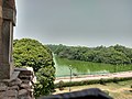
Lake in Hauz Khas Village in the year 2014.
Skyview of lake
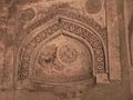
Islamic monument at Hauz Khas
Arc and wall design
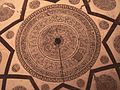
Dome design inside the tomb
Munda Gumbad in Deer Park
Idgah in Padmani EnclaveChor Minar
Points of interest and tourism
Historical Places like the Hauz Khas Complex which consists of the Hauz Khas Lake or Royal Tank, a mosque and a tomb, all from the time of the Khalji dynasty. Neeli Masjid and Chor Minar, where the heads of executed thieves (chor) would be put on display in the earlier days, lie inside the colony.
Hauz Khas is witnessing the growth of trendy shops and lodgings.[10] It is now becoming the center for domestic and international tourists and backpackers. The area also is home to historical monuments and has easy access to the Delhi Metro, making it a preferred location for many visitors to India and domestic middle-class visitors from other Indian states. The area attracts young tourists with numerous hip hostels and cafes.[2][3]
Accessibility
The domestic terminal of Indira Gandhi International Airport (Terminal 1) is 11 kilometres (6.8mi) from Hauz Khas while the international terminal (Terminal 3) is 16 kilometres (9.9mi).
This page is based on this Wikipedia article Text is available under the CC BY-SA 4.0 license; additional terms may apply. Images, videos and audio are available under their respective licenses.