
A tornado warning is a public warning that is issued to an area in the direct path of a tornado or a thunderstorm capable of producing a tornado. They are issued by weather forecasting agencies in some countries when an actual tornado or signs of a developing tornado, such as a funnel cloud or wall cloud, are reported by weather spotters, the public, or detected by weather radar.

A severe thunderstorm warning is a type of public warning for severe weather that is issued by weather forecasting agencies worldwide when one or more severe thunderstorms have been detected by Doppler weather radar, observed by weather spotters, or reported by an emergency management agency, law enforcement, or the general public. Unlike a watch, a warning is issued to areas in the direct path of active severe thunderstorms, that are expecting a direct impact typically within an hour. Severe thunderstorms can cause property damage and injury due to large hail, high winds, and flooding due to torrential rainfall. The exact criteria to issue a warning varies from country to country.

The National Weather Service (NWS) is an agency of the United States federal government that is tasked with providing weather forecasts, warnings of hazardous weather, and other weather-related products to organizations and the public for the purposes of protection, safety, and general information. It is a part of the National Oceanic and Atmospheric Administration (NOAA) branch of the Department of Commerce, and is headquartered in Silver Spring, Maryland, within the Washington metropolitan area. The agency was known as the United States Weather Bureau from 1890 until it adopted its current name in 1970.

The Storm Prediction Center (SPC) is a US government agency that is part of the National Centers for Environmental Prediction (NCEP), operating under the control of the National Weather Service (NWS), which in turn is part of the National Oceanic and Atmospheric Administration (NOAA) of the United States Department of Commerce (DoC).
A winter storm watch is issued by the National Weather Service of the United States when there is a possibility of heavy snow or potential of significant ice accumulations, without meeting a specific other winter criteria. The watch is typically issued 12 to 48 hours before the storm's expected arrival in the given area. The criteria for this watch can vary from place to place, which is true with other winter weather warning and advisories.

This article describes severe weather terminology used by the National Weather Service (NWS) in the United States. The NWS, a government agency operating as an arm of the National Oceanic and Atmospheric Administration (NOAA) branch of the United States Department of Commerce (DoC), defines precise meanings for nearly all of its weather terms.
The tornado outbreak of January 1–2, 2006, was one of the largest tornado outbreaks ever recorded in the month of January. The outbreak affected much of the Central and Southern United States and produced 20 tornadoes. The tornadoes caused considerable damage in the states of Kentucky and Georgia. There were no tornado related fatalities and only minor injuries were reported.
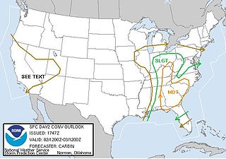
In weather forecasting in the United States, "particularly dangerous situation" (PDS) is enhanced wording used by the National Weather Service to convey special urgency in some watch or warning messages when there is a significant risk of extreme weather, most commonly from types of weather events that are usually less severe by comparison, such as a severe thunderstorm outbreak or flash flooding. It is used in the format "This is a particularly dangerous situation..." at the discretion of the issuing forecaster. A watch or warning bearing the phrase is referred to as a PDS watch or PDS warning as shorthand jargon.
A tornado emergency is an enhanced version of a tornado warning, which is used by the National Weather Service (NWS) in the United States during imminent, significant tornado occurrences in highly populated areas. Although it is not a new warning type from the NWS, issued instead within a severe weather statement or in the initial tornado warning, a tornado emergency generally means that significant, widespread damage is expected to occur and a high likelihood of numerous fatalities is expected with a large, strong to violent tornado.
A significant weather advisory was a hazardous weather statement issued by certain Weather Forecast Offices (WFO) of the National Weather Service (NWS) in the United States to alert the public of thunderstorm activity that is below designated severe criteria for and/or is not expected to produce severe weather. The title assigned to the advisory — alternately titled "significant weather alert" or referenced by its originating product, "special weather statement" — varied by the issuing WFO.

The tornado outbreak of October 17–19, 2007 was a widespread tornado outbreak that took place across much of the eastern half of North America starting on October 17, 2007, and continuing into the early hours of October 19. The outbreak was also responsible for five deaths; three in Michigan and two in Missouri, plus many injuries. At least 64 tornadoes were confirmed including 16 on October 17 across six states including Texas, Oklahoma, Arkansas, Louisiana, Mississippi and Missouri with wind damage reported in Oklahoma, Kansas, Illinois, Iowa, Arkansas and Mississippi. On October 18, at least 48 tornadoes were confirmed across eight states including Florida, Alabama, Mississippi, Tennessee, Kentucky, Illinois, Indiana and Michigan, plus widespread straight line wind damage. Until 2010, this event held the record for largest tornado outbreak ever recorded in the month of October according to NOAA.
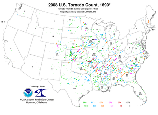
This page documents notable tornadoes and tornado outbreaks worldwide in 2008. Strong and destructive tornadoes form most frequently in the United States, Bangladesh, and Eastern India, but they can occur almost anywhere under the right conditions. Tornadoes also develop occasionally in southern Canada during the Northern Hemisphere's summer and somewhat regularly at other times of the year across Europe, Asia, and Australia. Tornadic events are often accompanied with other forms of severe weather, including strong thunderstorms, strong winds, and hail.

This page documents notable tornadoes and tornado outbreaks worldwide in 2009. Strong and destructive tornadoes form most frequently in the United States, Argentina, Brazil, Bangladesh, and Eastern India, but can occur almost anywhere under the right conditions. Tornadoes also develop occasionally in southern Canada during the Northern Hemisphere's summer and somewhat regularly at other times of the year across Europe, Asia, Argentina, Australia and New Zealand. Tornadic events are often accompanied by other forms of severe weather, including strong thunderstorms, strong winds, and hail. In the U.S., there were 1,304 reports of tornadoes received by the Storm Prediction Center (SPC), and 1,159 tornadoes were confirmed to have taken place. Worldwide, 73 fatalities were caused by tornadoes; 22 in the United States, 20 in India, 11 in Argentina, eight in the Philippines, four each in Canada and Brazil, two in Greece and one each in Serbia and Russia.
A weather warning generally refers to an alert issued by a meteorological agency to warn citizens of approaching dangerous weather. A weather watch, on the other hand, typically refers to an alert issued to indicate that conditions are favorable for the development of dangerous weather patterns, although the dangerous weather conditions themselves are not currently present.

From May 10–13, 2010, a major tornado outbreak affected large areas of Oklahoma, Kansas, Missouri, and Arkansas, with the bulk of the activity in central and eastern Oklahoma. Over 60 tornadoes, some large and multiple-vortex in nature, affected large parts of Oklahoma and adjacent parts of southern Kansas and Missouri, with the most destructive tornadoes causing severe damage in southern suburbs of the Oklahoma City metropolitan area and just east of Norman, Oklahoma, where the fatalities were reported from both tornado tracks. The outbreak was responsible for three fatalities, all of which occurred in Oklahoma. Damage was estimated to be over $595 million in central Oklahoma alone.
National Weather Service - Norman, Oklahoma is a Weather Forecast Office (WFO) of the National Weather Service based in Norman, Oklahoma, which is responsible for forecasts and the dissemination of weather warnings and advisories for central and most of western Oklahoma, and western portions of north Texas. It is located in the National Weather Center on the University of Oklahoma campus, where it acts as one of the NOAA Weather Partners, a group of close-together weather-related agencies of the National Oceanic and Atmospheric Administration. NWS Norman is currently overseen by Mark Fox, who serves as the Meteorologist In Charge of the office.

This page documents notable tornadoes and tornado outbreaks worldwide in 2018. Strong and destructive tornadoes form most frequently in the United States, Brazil, Bangladesh and Eastern India, but they can occur almost anywhere under the right conditions. Tornadoes also develop occasionally in southern Canada during the Northern Hemisphere's summer and somewhat regularly at other times of the year across Europe, Asia, Argentina and Australia. Tornadic events are often accompanied with other forms of severe weather, including strong thunderstorms, strong winds, and hail.

This page documents notable tornadoes and tornado outbreaks worldwide in 2020. Strong and destructive tornadoes form most frequently in the United States, Argentina, Brazil, Bangladesh, and eastern India, but can occur almost anywhere under the right conditions. Tornadoes also develop occasionally in southern Canada during the Northern Hemisphere's summer and somewhat regularly at other times of the year across Europe, Asia, Argentina, Australia and New Zealand. Tornadic events are often accompanied by other forms of severe weather, including strong thunderstorms, strong winds, and hail.

A late-season tornado outbreak in the Southern United States affected the states of Louisiana, Mississippi, Alabama, and Georgia, from the afternoon of November 29 into the morning of November 30, 2022. The outbreak was the result of an intense upper-level trough that materialized over the aforementioned states where increased moisture, atmospheric instability, and elevated wind shear were present, creating conditions highly conducive to supercell thunderstorms. Multiple tornadic storms developed in the risk area, producing numerous tornadoes. Several of these tornadoes were strong and destructive, prompting the issuance of multiple PDS tornado warnings. Two low-end EF3 tornadoes caused severe damage near Clarks, Louisiana and Tibbie, Alabama respectively while the Flatwood and Willow Springs communities north of Montgomery, Alabama was struck by an EF2 tornado, which caused two fatalities. Numerous weaker tornadoes also touched down, including a high-end EF1 tornado that caused considerable damage in Eutaw, Alabama. In all, 25 tornadoes were confirmed.

An intense low-pressure system produced widespread impacts across the United States in early March 2023. Additionally, an outbreak of 35 tornadoes affected 12 states from the Southern United States to the Great Lakes. In all, the storm system killed 13 people due to flooding and strong winds. At least 17 other people were injured.