
The Lizard is a peninsula in southern Cornwall, England, United Kingdom. The most southerly point of the British mainland is near Lizard Point at SW 701115; Lizard village, also known as The Lizard, is the most southerly on the British mainland, and is in the civil parish of Landewednack, the most southerly parish. The valleys of the River Helford and Loe Pool form the northern boundary, with the rest of the peninsula surrounded by sea. The area measures about 14 by 14 miles. The Lizard is one of England's natural regions and has been designated as a National Character Area 157 by Natural England. The peninsula is known for its geology and for its rare plants and lies within the Cornwall Area of Outstanding Natural Beauty (AONB).

The River Camel is a river in Cornwall, England. It rises on the edge of Bodmin Moor and with its tributaries its catchment area covers much of North Cornwall. The river flows into the eastern Celtic Sea between Stepper Point and Pentire Point having covered about 30 miles, making it the second longest river wholly in Cornwall. The river is tidal upstream to Egloshayle and is popular for sailing, birdwatching and fishing. The name Camel comes from the Cornish language for 'the crooked one', a reference to its winding course. Historically the river was divided into three named stretches. Heyl was the name for the estuary up to Egloshayle, the River Allen was the stretch between Egloshayle and Trecarne, whilst the Camel was reserved for the stretch of river between its source and Trecarne.

The River Fal flows through Cornwall, rising at Pentevale on Goss Moor and reaching the English Channel at Falmouth. On or near the banks of the Fal are the castles of Pendennis and St Mawes as well as Trelissick Garden. The River Fal separates the Roseland peninsula from the rest of Cornwall. Like most of its kind on the south coast of Cornwall and Devon, the Fal estuary is a classic ria, or drowned river valley. The Fal estuary from Tregony to the Truro River was originally called Hafaraell.

Gweek is a civil parish and village in Cornwall, England, United Kingdom. It is situated approximately three miles (5 km) east of Helston. The civil parish was created from part of the parish of Constantine by boundary revision in 1986. The name Gweek is first recorded as Gwyk in 1358 and is derived from the Cornish word gwig, meaning "forest village", cognate with the Welsh gwig and Old Breton guic. Gweek village has a pub, the Black Swan, and a combined shop and post office. The village is also home to the Cornish Seal Sanctuary.

Hayle is a port town and civil parish in west Cornwall, England, United Kingdom. It is situated at the mouth of the Hayle River and is approximately seven miles (11 km) northeast of Penzance.

Constantine is a village and civil parish in Cornwall, England, United Kingdom. It is situated approximately five miles (8 km) west-southwest of Falmouth. The electoral ward also bears the same name but includes Budock Water and the surrounding area. At the 2011 census, the population of the ward was 4,709 and the population of the civil parish was 1,789. The parish of Constantine is bounded by the parishes of Mabe, Mawnan, Gweek, Wendron and the north bank of the Helford River.

Carrick Roads is the estuary of the River Fal on the south coast of Cornwall in England. It joins the English Channel at its southern end near Falmouth.
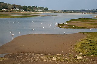
The Hayle Estuary is an estuary in west Cornwall, England, United Kingdom. It is one of the few natural harbours on the north coast of south-west England and during the prehistoric and early medieval periods was important for trade and the movement of people and ideas.
Sir Richard Rawlinson Vyvyan, 8th Baronet was an English landowner and Tory politician who sat in the House of Commons variously between 1825 and 1857.

The Vyvyans are a prominent Cornish family who were members of Parliament, baronets, and landowners in Penwith and Kerrier since the 15th century. The Vyvyan family have held the large Trelowarren Estate in the parish of Mawgan-in-Meneage in west Cornwall for nearly 600 years. They moved to Trelowarren in 1427 from Trevegean, St. Buryan when they acquired Trelowarren through marriage to the daughter of Honora Ferrers, heiress to the estate of the previous owner, Richard Ferrers. Trelowarren's first garden is recorded in 1428. In the English Civil War (1642–1651) the Vyvyans were royalist supporters. Sir Richard Vyvyan (1613–1724), 1st Baronet, was given a large equestrian portrait of King Charles I (1600–1649), a copy of the famous painting by Anthony van Dyck, by King Charles II (1630–1685) in recognition of his support.

Porth Navas is a small village in Cornwall, England, UK. The village was called "Cove" until the 19th century development as a granite port and is at the head of a short creek running off the main limb which runs north from the Helford River. It is between Mawnan Smith and Constantine within the civil parish of Constantine.

Port Navas Creek, or Porthnavas Creek, is one of seven creeks off the Helford River in Cornwall, England, United Kingdom. It splits into three sections with the village of Porth Navas on the west, Trenarth Bridge in the middle and the eastern one is near Budock Veane. The creek is well known for the oyster beds.
Bishop's Quay is a hamlet in south-west Cornwall, England, United Kingdom. It is in the civil parish of St. Martin-in-Meneage. It is situated on the south bank of the tidal Mawgan Creek at its confluence with the Helford River five miles (8 km) east of Helston. The Cornish Seal Sanctuary at Gweek is half-a-mile away on the north bank of the Helford River.

Fishing in Cornwall, England, UK, has traditionally been one of the main elements of the economy of the county. Pilchard fishing and processing was a thriving industry in Cornwall from around 1750 to around 1880, after which it went into an almost terminal decline. During the 20th century the varieties of fish taken became much more diverse and crustaceans such as crab and lobster are now significant. Much of the catch is exported to France due to the higher prices obtainable there. Though fishing has been significantly damaged by overfishing, the Southwest Handline Fishermen's Association has started to revive the fishing industry. As of 2007, stocks were improving. The Cornwall Sea Fisheries Committee is one of 12 committees responsible for managing the corresponding Sea Fisheries District. The Isles of Scilly Sea Fisheries Committee is responsible for the Scilly district.

Restronguet Creek is a tidal ria in south Cornwall, United Kingdom. It is a tributary of Carrick Roads, the estuary of the River Fal, and is situated approximately four miles (6.5 km) south of Truro and three miles (5 km) north of Falmouth.

Chycoose, Point and Penpol form a coastal settlement around Penpol Creek in Cornwall, England, United Kingdom.

Porthallow is a small fishing village on the east coast of The Lizard peninsula to the south of the Helford River, in Cornwall, England. It lies in St Keverne parish, north of St Keverne village. One road runs through the village, and there is public house, the Five Pilchards, named for the pilchard fishery. Porthallow is at the midpoint of the South West Coast Path and is within the Cornwall Area of Outstanding Natural Beauty (AONB).

Merthen Manor is a 16th-century manor house in west Cornwall, England, UK. For most of its history it has been in the ownership of the prominent Cornish family, the Vyvyan family. The house is set in over 100 acres (40 ha) of woodland which, along with the shoreline of the Helford River, is designated as Merthen Woods Site of Special Scientific Interest (SSSI).
The following outline is provided as an overview of and topical guide to Cornwall: Cornwall – ceremonial county and unitary authority area of England within the United Kingdom. Cornwall is a peninsula bordered to the north and west by the Celtic Sea, to the south by the English Channel, and to the east by the county of Devon, over the River Tamar. Cornwall is also a royal duchy of the United Kingdom. It has an estimated population of half a million and it has its own distinctive history and culture.

The Percuil River is an estuary and stream draining the southern part of the Roseland Peninsula of Cornwall, UK and is one of three major tidal creeks of the River Fal. The small port and holiday destination of St Mawes is on the western shore and is linked to Place Creek on the eastern shore by the Place Ferry. The ferry is used by walkers on the South West Coast Path.


