The River Fowey is a river in Cornwall, England, United Kingdom.

The Tamar is a river in south west England that forms most of the border between Devon and Cornwall. A part of the Tamar Valley is a World Heritage Site due to its historic mining activities.

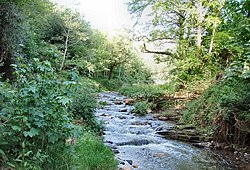
The River Camel is a river in Cornwall, England. It rises on the edge of Bodmin Moor and with its tributaries its catchment area covers much of North Cornwall. The river flows into the eastern Celtic Sea between Stepper Point and Pentire Point having covered about 30 miles, making it the second longest river wholly in Cornwall. The river is tidal upstream to Egloshayle and is popular for sailing, birdwatching and fishing. The name Camel comes from the Cornish language for 'the crooked one', a reference to its winding course. Historically the river was divided into three named stretches. Heyl was the name for the estuary up to Egloshayle, the River Allen was the stretch between Egloshayle and Trecarne, whilst the Camel was reserved for the stretch of river between its source and Trecarne.
Camelford is a town and civil parish in north Cornwall, England, United Kingdom, situated in the River Camel valley northwest of Bodmin Moor. The town is approximately ten miles (16 km) north of Bodmin and is governed by Camelford Town Council. Lanteglos-by-Camelford is the ecclesiastical parish in which the town is situated. The ward population at the 2011 Census was 4,001. The town population at the same census was 865.

Boscastle is a village and fishing port on the north coast of Cornwall, England, in the civil parish of Forrabury and Minster. It is 14 miles (23 km) south of Bude and 5 miles (8 km) northeast of Tintagel. The harbour is a natural inlet protected by two stone harbour walls built in 1584 by Sir Richard Grenville and is the only significant harbour for 20 miles (32 km) along the coast. The village extends up the valleys of the River Valency and River Jordan. Heavy rainfall on 16 August 2004 caused extensive damage to the village.

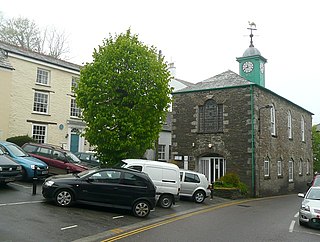
Wadebridge is a town and civil parish in north Cornwall, England, United Kingdom. The town straddles the River Camel five miles upstream from Padstow. The permanent population was 6,222 in the census of 2001, increasing to 7,900 in the 2011 census. There are two electoral wards in the town. Their total population is 8,272.

The Helford River is a ria in Cornwall, England, fed by small streams into its many creeks. There are seven creeks on the Helford; from west to east these are Ponsontuel Creek, Mawgan Creek, Polpenwith Creek, Polwheveral Creek, Frenchman's Creek, Port Navas Creek, and Gillan Creek. The best known of these is Frenchman's Creek, made famous by Daphne du Maurier in her novel of the same name. A little further up river is Tremayne Quay, built for a visit by Queen Victoria in the 1840s which she then declined to make, allegedly because it was raining.

The River Colne is a small river that runs through Essex, England and passes through Colchester. It is not a tributary of any other river, instead having an estuary that joins the sea near Brightlingsea. The river's name is of Celtic origin, combining the word for rock "cal" with a remnant of the word "afon", or river, giving the meaning "stony river". However, another authority states that the river's name was originally Colonia Fluvius, the "waterway of the Colonia": a reference to Colchester's status in Roman times. There are two other rivers in the UK that share the same name.

The River Tolka, also once spelled Tolga, is one of Dublin's three main rivers, flowing from County Meath to Fingal within the old County Dublin, and through the north of Dublin city, Ireland. By flow of water, the Tolka is the second largest river in Dublin, following the Liffey, but runs more slowly than the Dodder.

Lesnewth is a civil parish and village in Cornwall, England, United Kingdom. It is about six miles east of Tintagel Head and two miles east of Boscastle.
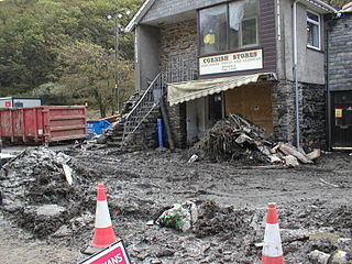
The 2004 Boscastle flood occurred on Monday, 16 August 2004 in the two villages of Boscastle and Crackington Haven in Cornwall, England, United Kingdom. The villages suffered extensive damage after flash floods caused by an exceptional amount of rain that fell over eight hours that afternoon. The flood in Boscastle was filmed and extensively reported but the floods in Crackington Haven and Rocky Valley were not mentioned beyond the local news. The floods were the worst in local memory. A study commissioned by the Environment Agency from hydraulics consulting firm HR Wallingford concluded that it was among the most extreme ever experienced in Britain. The peak flow was about 140 m3/s, between 5:00 pm and 6:00 pm BST. The annual chance of this flood in any one year is about 1 in 400. The probability each year of the heaviest three-hour rainfall is about 1 in 1300. At midday on 16 August 2004, heavy thundery showers had developed across the South West due to a weak disturbance to the northeast of the United Kingdom.

The geography of Cornwall describes the extreme southwestern peninsula of England west of the River Tamar. The population of Cornwall is greater in the less extensive west of the county than the east due to Bodmin Moor's location; however the larger part of the population live in rural areas. It is the only county in England bordered by only one other county, Devon, and is the 9th largest county by area, encompassing 3,563 km² (1,376 mi²). The length of the coast is large in proportion to the area of the county. Cornwall is exposed to the full force of the prevailing south-westerly winds that blow in from the Atlantic Ocean. To the north is the Celtic Sea, and to the south the English Channel.

The River Menalhyl is a river in Cornwall, England, that flows through the civil parishes of St Columb Major and Mawgan-in-Pydar. Its length is about 12 miles and it flows in a generally north-west direction. The name comes from the Cornish words melyn meaning mill and heyl meaning estuary - estuary mills. The name was recorded as Mellynheyl in the 19th century, but it had been known as Glyvion.

Forrabury and Minster is a civil parish on the north coast of Cornwall, England, United Kingdom. The parish was originally divided between the coastal parish of Forrabury and inland parish of Minster until they were united on the 1st of April 1919.
Saint Materiana is a Welsh saint, patron of two churches in Cornwall and one in Wales. Alternative spellings are Madrun and Madryn. The name was corrupted to "Marcelliana" in medieval times. Another spelling of her name sometimes used is "Mertheriana" or "Merthiana", resembling the Welsh merthyr - "martyr".


Fishing in Cornwall, England, UK, has traditionally been one of the main elements of the economy of the county. Pilchard fishing and processing was a thriving industry in Cornwall from around 1750 to around 1880, after which it went into an almost terminal decline. During the 20th century the varieties of fish taken became much more diverse and crustaceans such as crab and lobster are now significant. Much of the catch is exported to France due to the higher prices obtainable there. Though fishing has been significantly damaged by overfishing, the Southwest Handline Fishermen's Association has started to revive the fishing industry. As of 2007, stocks were improving. The Cornwall Sea Fisheries Committee is one of 12 committees responsible for managing the corresponding Sea Fisheries District. The Isles of Scilly Sea Fisheries Committee is responsible for the Scilly district.

The River Ottery is a small river in northeast Cornwall, England, United Kingdom. The river is about twenty miles (32 km) long from its source southeast of Otterham to its confluence with the River Tamar at Nether Bridge, two miles (3.2 km) northeast of Launceston.

The St Austell River properly known as the River Vinnick, but historically called The White River, is a 12 kilometres (7.5 mi) long river located in south Cornwall, England, United Kingdom. 50.337°N 4.793°W. The river has also been known as the "red river" due to tin streaming and mining activity upstream.