A county seat is an administrative center, seat of government, or capital city of a county or civil parish. The term is used in Canada, China, Romania, Taiwan and the United States. County towns have a similar function in the United Kingdom and Republic of Ireland, and historically in Jamaica.
Hendersonville may refer to:

Yalobusha County is a county located in the U.S. state of Mississippi. As of the 2010 census, the population was 12,678. Its county seats are Water Valley and Coffeeville.

Tallahatchie County is a county in the U.S. state of Mississippi. At the 2010 census, the population was 15,378. Its county seats are Charleston and Sumner.

Panola County is a county located in the U.S. state of Mississippi. As of the 2010 census, the population was 34,707. Its county seats are Sardis and Batesville. Panola is the anglicization of ponolo, a word meaning thread in both old Choctaw and Chickasaw and cotton in modern Choctaw. The county is located just east of the Mississippi Delta and bisected by the Tallahatchie River flowing to the southwest, separating the two county seats.

Carrollton is a town in and the second county seat of Carroll County, Mississippi, United States, which is within the Mississippi Delta. The population was 190 at the 2010 census, down from 408 in 2000. Centrally located in the county, the town is part of the Greenwood, Mississippi micropolitan area. The first county seat, Vaiden, Mississippi, was founded in the eastern part of the county during its early settlement.

Grenada is a city in Grenada County, Mississippi, United States. The population was 13,092 at the 2010 census. It is the county seat of Grenada County.
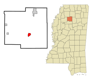
Coffeeville is a town in Yalobusha County, Mississippi, United States. The population was 905 at the 2010 census. It is named after John Coffee, a planter and military leader. It is near the site of the minor American Civil War Battle of Coffeeville, in December 1862.

Tillatoba is a town in Yalobusha County, Mississippi, United States. The population was 91 at the 2010 census.

Hendersonville is a city in Henderson County, North Carolina, United States. It is 22 miles (35 km) south of Asheville and is the county seat of Henderson County. Like the county, the city is named for 19th-century North Carolina Supreme Court Chief Justice Leonard Henderson.

Plum is a borough in Allegheny County in the U.S. state of Pennsylvania. A suburb of Pittsburgh, Pennsylvania, it is located northeast of the city of Pittsburgh, in what is commonly referred to as the East Hills suburbs. The population was 27,126 at the 2010 census.

The Yalobusha River is a river, 165 miles (266 km) long, in north-central Mississippi in the United States. It is a principal tributary of the Yazoo River, via which it is part of the watershed of the Mississippi River.

The Holly Springs National Forest (HSNF) was established by the United States Forest Service on June 15, 1936 during the tenure of United States Department of Agriculture Chief Forester Ferdinand A. Silcox. That same year, it was combined administratively with the Bienville, De Soto and Homochitto national forests, known collectively as "National Forests in Mississippi." The Holly Springs Ranger District controls 155,661 acres (243.2 sq mi) of Forest Service land, interspersed with 530,000 acres (828.1 sq mi) of privately owned properties, within the national forest's proclamation zone.

The Skuna River is a tributary of the Yalobusha River, about 75 mi (120 km) long, in north-central Mississippi in the United States. Via the Yalobusha and Yazoo Rivers, it is part of the watershed of the Mississippi River.
The Coffeeville School District is a public school district based in Coffeeville, Mississippi (USA).

The Mississippi & Skuna Valley Railroad (MSV) was a 22-mile a shortline railroad that operated in Mississippi from 1925 to 2008.

Princeton is a ghost town located in Washington County, Mississippi, United States.
Leggo is a ghost town in Yalobusha County, Mississippi, United States.
Mississippi Highway 335 was a state highway in central Mississippi. The route started at MS 8 near Gore Springs, and it traveled northward over eastern Grenada County. MS 335 then crossed over the Grenada Lake and entered Yalobusha County. The route continued northward and ended at MS 330 near Gums. MS 335 was designated around 1958, from the Grenada–Yalobusha county line to MS 330. It was extended southwards in 1960 to MS 8, before being removed from the state highway system by 1967.

