
Cass County is a county in the U.S. state of North Dakota. As of the 2020 census, the population was 184,525. Cass County is the most populous county in North Dakota, accounting for nearly 24% of the state's population. The county seat is Fargo, the state's most populous city.

Alice is a city in Cass County, North Dakota, United States. The population was 41 at the 2020 census.

Fargo is a city in and the county seat of Cass County, North Dakota, United States. According to the 2020 census, its population was 125,990, making it the most populous city in the state and the 219th-most populous city in the United States. Fargo, along with its twin city of Moorhead, Minnesota, and the adjacent cities of West Fargo, North Dakota and Dilworth, Minnesota, form the core of the Fargo–Moorhead, ND-MN Metropolitan Statistical Area (MSA). The MSA had a population of 248,591 in 2020.

Gardner is a city in Cass County, North Dakota, United States. The population was 129 at the 2020 census.

Harwood is a city in Cass County, North Dakota, United States. The population was 794 at the 2020 census. It has become a bedroom community of the nearby Fargo-Moorhead area. Harwood was founded in 1881.
Kindred is a city in Cass County, North Dakota, United States. The population was 889 at the time of the 2020 census. Kindred primarily serves as a bedroom community for Fargo, located about 25 miles to the southwest.
Mapleton is a city in Cass County, North Dakota, United States. It sits on the banks of the Maple River. The population was 1,320 at the 2020 census. Mapleton serves as a bedroom community of the Fargo-Moorhead metropolitan area. The core cities are ten miles to the east of Mapleton.

Wheatland is a census-designated place (CDP) in Cass County, North Dakota, United States. The population was 68 at the 2010 census.

Lewis Cass was an American military officer, politician, and statesman. He represented Michigan in the United States Senate and served in the Cabinets of two U.S. Presidents, Andrew Jackson and James Buchanan. He was also the 1848 Democratic presidential nominee. A slave owner himself, he was a leading spokesman for the doctrine of popular sovereignty, which held that the people in each territory should decide whether to permit slavery.

Fargo–Moorhead, also known as the FM area, is a common name given to the metropolitan area comprising Fargo, North Dakota; Moorhead, Minnesota; and the surrounding communities. These two cities lie on the North Dakota–Minnesota border, on opposite banks of the Red River of the North. The region is the cultural, retail, health care, educational, and industrial center of southeastern North Dakota and northwestern Minnesota.

Absaraka is an unincorporated community in central Cass County, North Dakota, United States. It lies northwest of the city of Fargo, the county seat of Cass County.
Chaffee is an unincorporated community in Cass County, North Dakota, United States.
Embden is a census-designated place and unincorporated community in Cass County, North Dakota, United States. Its population was 59 as of the 2010 census.

Wild Rice is an unincorporated community in Cass County, North Dakota, United States. Wild Rice is located near the Wild Rice River, 9 miles (14 km) south of downtown Fargo.
Durbin is an unincorporated community in Cass County, in the U.S. state of North Dakota.
Lynchburg is an unincorporated community in Cass County, in the U.S. state of North Dakota.
Prosper is an unincorporated community in Cass County, in the U.S. state of North Dakota.
Arthur Township is a civil township in Cass County, in the U.S. state of North Dakota.
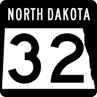
North Dakota Highway 32 is a north–south highway located that traverses portions of nine counties in eastern North Dakota. The 236.674-mile-long (380.890 km) highway is one of several north–south routes in the state that connects the Canadian border to the state's southern border with South Dakota.


