North River, North Dakota

Last updated

North River, North Dakota
North River, North Dakota 10-13-2007.jpg
Sign in North River
ND Cass County North River.svg
Location of North River, North Dakota
Coordinates: 46°57′01″N96°48′08″W / 46.95028°N 96.80222°W / 46.95028; -96.80222
CountryUnited States
State North Dakota
County Cass
Founded1973
Government
   Mayor Troy Durham
Area
[1]
  Total0.06 sq mi (0.16 km2)
  Land0.06 sq mi (0.16 km2)
  Water0.00 sq mi (0.01 km2)
Elevation
[2]
896 ft (273 m)
Population
 (2020) [3]
  Total55
  Estimate 
(2022) [4]
56
  Density901.64/sq mi (349.30/km2)
Time zone UTC-6 (Central (CST))
  Summer (DST) UTC-5 (CDT)
ZIP code
58102
Area code 701
FIPS code 38-58120
GNIS feature ID1036197 [2]

North River is a city in Cass County, North Dakota, United States. The population was 55 at the 2020 census. [3] North River was founded in 1973. It is a suburb/bedroom community directly adjacent to the city of Fargo.

Contents

Geography

According to the United States Census Bureau, the city has a total area of 0.07 square miles (0.18 km2), of which 0.06 square miles (0.16 km2) is land and 0.01 square miles (0.03 km2) is water. [5]

Demographics

Historical population
CensusPop.Note
1980 65
1990 684.6%
2000 65−4.4%
2010 56−13.8%
2020 55−1.8%
2022 (est.)56 [4] 1.8%
U.S. Decennial Census [6]
2020 Census [3]

2010 census

As of the census of 2010, there were 56 people, 23 households, and 21 families living in the city. The population density was 933.3 inhabitants per square mile (360.3/km2). There were 24 housing units at an average density of 400.0 per square mile (154.4/km2). The racial makeup of the city was 100.0% White.

There were 23 households, of which 26.1% had children under the age of 18 living with them, 78.3% were married couples living together, 8.7% had a female householder with no husband present, 4.3% had a male householder with no wife present, and 8.7% were non-families. 8.7% of all households were made up of individuals. The average household size was 2.43 and the average family size was 2.48.

The median age in the city was 47.5 years. 17.9% of residents were under the age of 18; 3.6% were between the ages of 18 and 24; 23.3% were from 25 to 44; 48.2% were from 45 to 64; and 7.1% were 65 years of age or older. The gender makeup of the city was 53.6% male and 46.4% female.

2000 census

As of the census of 2000, there were 65 people, 19 households, and 19 families living in the city. The population density was 1,017.5 inhabitants per square mile (392.9/km2). There were 19 housing units at an average density of 297.4 per square mile (114.8/km2). The racial makeup of the city was 100.00% White.

There were 19 households, out of which 63.2% had children under the age of 18 living with them, 89.5% were married couples living together, 10.5% had a female householder with no husband present, and 0.0% were non-families. No households were made up of individuals, and none had someone living alone who was 65 years of age or older. The average household size was 3.42 and the average family size was 3.37.

In the city, the population was spread out, with 32.3% under the age of 18, 7.7% from 18 to 24, 23.1% from 25 to 44, and 36.9% from 45 to 64. The median age was 38 years. For every 100 females, there were 140.7 males. For every 100 females age 18 and over, there were 120.0 males.

The median income for a household in the city was $80,000, and the median income for a family was $80,000. Males had a median income of $41,250 versus $29,583 for females. The per capita income for the city was $22,584. None of the population and none of the families were below the poverty line.

Related Research Articles

<span class="mw-page-title-main">Eagle, Idaho</span> City in Idaho, United States

Eagle is a city in Ada County, Idaho, United States, 10 miles (16 km) northwest of Boise. The population was 30,346 at the 2020 census.

<span class="mw-page-title-main">Kendrick, Idaho</span> City in Idaho, United States

Kendrick is a city in Latah County, Idaho, United States. Its population was 303 at the 2010 census, a decrease from 369 in 2000.

<span class="mw-page-title-main">Fairbank, Iowa</span> City in Iowa, United States

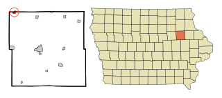
Fairbank is a city in Buchanan and Fayette counties in the U.S. state of Iowa. The population was 1,111 at the time of the 2020 census.

<span class="mw-page-title-main">Hayesville, Iowa</span> City in Iowa, United States

Hayesville is a city in Keokuk County, Iowa, United States. The population was 41 at the time of the 2020 census.

<span class="mw-page-title-main">Webster, Iowa</span> City in Iowa, United States

Webster is a city in Keokuk County, Iowa, United States. The population was 94 at the time of the 2020 census.

<span class="mw-page-title-main">Ramsey, Minnesota</span> City in Minnesota, United States

Ramsey is a suburban city 22 miles (35 km) north-northwest of downtown Minneapolis in Anoka County, Minnesota, United States. The population was 27,646 at the 2020 census. It is a northwest suburb of the Twin Cities.

<span class="mw-page-title-main">Lake Shore, Minnesota</span> City in Minnesota, United States

Lake Shore is a city in Cass County, Minnesota, United States. The population was 1,056 at the 2020 census. It is part of the Brainerd Micropolitan Statistical Area.

<span class="mw-page-title-main">Lilydale, Minnesota</span> City in Minnesota, United States

Lilydale is a city in Dakota County, Minnesota, United States. The population was 623 at the 2010 census.

<span class="mw-page-title-main">Harding, Minnesota</span> City in Minnesota, United States

Harding is a city in Morrison County, Minnesota, United States, along the Platte River. The population was 123 at the 2020 census.

<span class="mw-page-title-main">Erhard, Minnesota</span> City in Minnesota, United States

Erhard is a city in Otter Tail County, Minnesota, United States. The population was 132 at the 2020 census.

<span class="mw-page-title-main">Urbank, Minnesota</span> City in Minnesota, United States

Urbank is a city in Otter Tail County, Minnesota, United States. The population was 52 at the 2020 census.

<span class="mw-page-title-main">Nelson, Missouri</span> City in Missouri, United States

Nelson is a city in Saline County, Missouri, United States. The population was 152 at the 2020 census.

<span class="mw-page-title-main">Federal Dam, Minnesota</span> City in Minnesota, United States

Federal Dam is a city in Cass County, Minnesota, United States, near Leech Lake. The population was 110 at the 2010 census. It is part of the Brainerd Micropolitan Statistical Area.

<span class="mw-page-title-main">Clarkson Valley, Missouri</span> City in Missouri, United States

Clarkson Valley is a city in St. Louis County, Missouri, United States. The population was 2,609 at the 2020 census.

<span class="mw-page-title-main">Kramer, North Dakota</span> City in North Dakota, United States

Kramer is a city in Bottineau County, North Dakota, United States. The population was 24 at the 2020 census. Kramer was founded in 1905.

<span class="mw-page-title-main">Dunes City, Oregon</span> City in Oregon, United States

Dunes City is a city in Lane County, Oregon, United States. The population was 1,303 at the 2010 census.

<span class="mw-page-title-main">Harrisburg, Oregon</span> City in Oregon, United States

Harrisburg is a city in Linn County, Oregon, United States. The population was 3,567 at the 2010 census.

<span class="mw-page-title-main">Crooks, South Dakota</span> City in South Dakota, United States

Crooks is a city in Minnehaha County, South Dakota, United States and is a suburb of Sioux Falls. The population was 1,362 at the 2020 census. Crooks was named New Hope until 1904. The town's present name honors W. A. Crooks, a local politician.

<span class="mw-page-title-main">Bancroft, West Virginia</span> Town in West Virginia, United States

Bancroft is a town in Putnam County, West Virginia, United States, along the Kanawha River. The population was 389 at the 2020 census. It is part of the Huntington–Ashland metropolitan area.

<span class="mw-page-title-main">Camden-on-Gauley, West Virginia</span> Town in West Virginia, United States

Camden-on-Gauley is a town in Webster County, West Virginia, United States, along the Gauley River. The population was 126 at the 2020 census.

References

  1. "ArcGIS REST Services Directory". United States Census Bureau. Retrieved September 20, 2022.
  2. 1 2 U.S. Geological Survey Geographic Names Information System: North River, North Dakota
  3. 1 2 3 "Explore Census Data". United States Census Bureau . Retrieved November 29, 2023.
  4. 1 2 "City and Town Population Totals: 2020-2022". United States Census Bureau. November 29, 2023. Retrieved November 29, 2023.
  5. "US Gazetteer files 2010". United States Census Bureau. Archived from the original on July 2, 2012. Retrieved June 14, 2012.
  6. United States Census Bureau. "Census of Population and Housing" . Retrieved July 21, 2013.