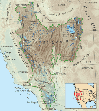
The Great Basin is the largest area of contiguous endorheic watersheds, those with no outlets, in North America. It spans nearly all of Nevada, much of Utah, and portions of California, Idaho, Oregon, Wyoming, and Baja California. It is noted for both its arid climate and the basin and range topography that varies from the North American low point at Badwater Basin in Death Valley to the highest point of the contiguous United States, less than 100 miles (160 km) away at the summit of Mount Whitney. The region spans several physiographic divisions, biomes, ecoregions, and deserts.

The Black Rock Desert is a semi-arid region of lava beds and playa, or alkali flats, situated in the Black Rock Desert–High Rock Canyon Emigrant Trails National Conservation Area, a silt playa 100 miles (160 km) north of Reno, Nevada that encompasses more than 300,000 acres (120,000 ha) of land and contains more than 120 miles (200 km) of historic trails. It is in the northern Nevada section of the Great Basin with a lakebed that is a dry remnant of Pleistocene Lake Lahontan.

Lassen National Forest is a United States national forest of 1,700 square miles (4,300 km2) in northeastern California. It is named after pioneer Peter Lassen, who mined, ranched and promoted the area to emigrant parties in the 1850s.

The Black Ridge Canyons Wilderness (BRCW) is located in western Colorado with a small portion extending into eastern Utah, USA, within the arid Colorado Plateau region approximately 15 miles (24 km) west of Grand Junction, Colorado. The wilderness lies on the northwest flank of the Uncompahgre Plateau. It is characterized by the high, east-west trending Black Ridge dissected by seven major canyon systems, draining into the Colorado River in Ruby Canyon. Elevations range from 4,700 feet (1,400 m) above sea level along the river to 6,800 feet (2,070 m). Canyons vary in length from several miles to twelve miles in length and may contain interesting side canyons. Geological features in these canyons include spires, windows, giant alcoves and desert varnish. Canyons may reach a depth of almost 1,000 feet (300 m), forming spectacular red rock cliffs. Spring runoff and summer thunderstorms create glistening waterfalls and plunge pools. Rattlesnake Canyon contains the second largest concentration of natural arches in the country. Mee Canyon is even more remote, and contains Arch Tower.

The Black Rock Range is a mountain range in northwestern Nevada. It is named for Black Rock Point, which is located at the southern end of the range. The Black Rock Range divides the Black Rock Desert into eastern and western arms. Pahute Peak, also known as Big Mountain, is the highest point in the range at 8,566 feet (2,611 m) above sea level.

The Calico Hills or Calico Mountains are a mountain range in northwestern Nevada. The range runs north to south along the western edge of the Black Rock Desert. This mountain range is located in western Humboldt County and the northwestern corner of Pershing County, approximately 30 miles north of the town of Gerlach, Nevada. The best access to the Calico Hills is located from the maintained Soldier Meadows Road that forms its eastern boundary.

The mountains in the McCullough Range lie mostly above the city of Henderson in the U.S. state of Nevada. The range has two distinct areas with the northern portion being primarily volcanic in origin, while the southern part of the range is primarily composed of metamorphic rock.
Calico Mountains Wilderness is a U S Wilderness Area in Nevada under the Bureau of Land Management. It is located in the Calico Hills.
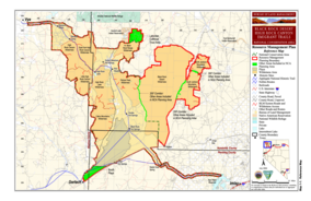
The Black Rock Desert–High Rock Canyon Emigrant Trails National Conservation Area is the federal land in northwestern Nevada, under the Bureau of Land Management-BLM management and protection, and the ten Wilderness Areas within it.
The Black Rock Desert Wilderness is a U S Wilderness Area in Nevada under the Bureau of Land Management. It is located in the east arm of the Black Rock Desert playa east of the Black Rock Range and west of the Jackson Mountains. The wilderness has a land area of 314,829 acres, or 1,274.1 km². It is the largest U.S. designated wilderness area that is managed solely by the Bureau of Land Management, and the largest that is not located within a National Forest, National Park, or National Wildlife Refuge. It is located within the Black Rock Desert – High Rock Canyon Emigrant Trails National Conservation Area, also managed by the BLM.
The East Fork High Rock Canyon Wilderness is a U S Wilderness Area in Nevada under the Bureau of Land Management. It is located on the northeast side of High Rock Canyon but does not include the 4x4 trail inside High Rock Canyon nor a 4x4 trail to the Yellow Hills.
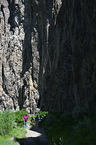
The High Rock Canyon Wilderness is a U S Wilderness Area in Nevada under the Bureau of Land Management. It is located on the southwest side of High Rock Canyon and north of the Little High Rock Canyon Wilderness. It does not include the 4x4 trail in High Rock Canyon.
The Little High Rock Canyon Wilderness is a US Wilderness Area in Nevada under the Bureau of Land Management. It is located south of the High Rock Canyon Wilderness and west of the High Rock Lake Wilderness.
The North Black Rock Range Wilderness is a U S Wilderness Area in Nevada under the Bureau of Land Management. It is located northeast of Soldier Meadows and south of the Summit Lake Indian Reservation.
The North Jackson Mountains Wilderness is a U S Wilderness Area in Nevada under the Bureau of Land Management. It is located in the Jackson Mountains north of the South Jackson Mountains Wilderness and east of the Black Rock Desert Wilderness.
The Pahute Peak Wilderness is a U S Wilderness Area in Nevada under the Bureau of Land Management. It is located in the central Black Rock Range west of the Black Rock Desert Wilderness.
The South Jackson Mountains Wilderness is a U.S. Wilderness Area in Nevada under the Bureau of Land Management. It is located in the Jackson Mountains, south of the North Jackson Mountains Wilderness and east of the Black Rock Desert Wilderness.

The Kiavah Wilderness is a federally designated wilderness area located in the Mojave Desert, Scodie Mountains, and southern Sierra Nevada in Kern County, California, United States. California State Route 178 connects the town of Lake Isabella to State Highway 14 in the east, crossing Walker Pass at the north boundary of the wilderness.

The Owyhee River Wilderness is located on the high basalt plateaus of Owyhee County in southwestern Idaho in the western United States. The wilderness area is named after and protects the upper Owyhee River, its tributaries, and the surrounding desert canyon landscape. Whitewater rafting is a popular recreational activity in this wilderness area. Managed by the Bureau of Land Management, it is the second-largest U.S. Wilderness Area that is not located within a National Forest, National Park, or National Wildlife Refuge. The BLM's Black Rock Desert Wilderness, located within Black Rock Desert – High Rock Canyon Emigrant Trails National Conservation Area, is larger. About 67.3 miles (108.3 km) of the Owyhee River is classified as a wild river.
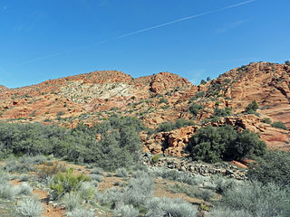
Cottonwood Canyon Wilderness is a 11,712-acre (47.4 km2) wilderness area in the US state of Utah. It was designated March 30, 2009, as part of the Omnibus Public Land Management Act of 2009. Located adjacent to the southern edge of the Dixie National Forest, it encompasses and protects a transition zone between the Colorado Plateau to the east and the Mojave Desert to the west. It is bordered by the Cottonwood Forest Wilderness to the northeast and is itself a part of the Red Cliffs National Conservation Area.