Springfield is a historic neighborhood of Jacksonville, Florida, United States, located to the north of downtown. Established in 1869, it experienced its greatest growth from the early 1880s through the 1920s. The Springfield Historic District is listed in the National Register of Historic Places, and contains some of the city's best examples of 19th and early 20th century architecture.

Lyon Village is a neighborhood, or "urban village" located in Arlington County, Virginia, along Lee Highway. It adjoins Arlington County's government center, and is approximately one mile west of Rosslyn and less than a mile north of Clarendon, of which it is sometimes considered a sub-neighborhood, as is Cherrydale, the mostly residential district immediately west of Lyon Village.

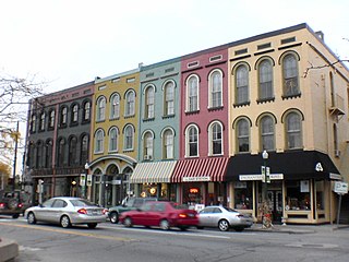
The Rochester Downtown Historic District is a historic district on the National Register of Historic Places (NRHP) in Rochester, Indiana, United States. It was placed on the Register on June 24, 2008. The majority of buildings in the area are masonry and Italianate while structures outside the district are largely residential frame built structures.

The North Hatfield Historic District encompasses a small rural village in Hatfield, Massachusetts. It consists of a small cluster of buildings along West Street and Depot Road in the vicinity of a former railroad station. It includes a few buildings associated with the railroad, including a depot and freight buildings, as well as commercial and residential structures, most of which postdate the 1848 arrival of the railroad. The village was important in the community as an arrival point for immigrants working in its fields and industry. The district was listed on the National Register of Historic Places in 1997.

The Lake Linden Historic District is located in the village of Lake Linden in Houghton County, Michigan.
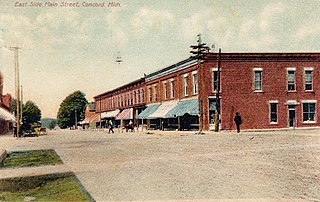
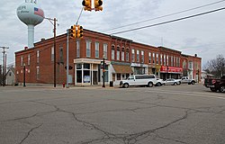
The Concord Village Historic District in Concord, Michigan dates back to 1836, and consists of historic structures located along Hanover Street from Spring to Michigan Streets and North Main Street from Railroad to Monroe Streets. It was listed on the National Register of Historic Places in 1996.
The Ypsilanti Historic District is a historic district located along several blocks on each side of the Huron River in the center of Ypsilanti, Michigan. The original portion of the district was designated a Michigan State Historic Site in 1973 and listed on the National Register of Historic Places in 1978; additions to the district were nationally listed in 1989.

The Main Street Historic District is a commercial historic district that includes structures located at 3-153 East Main Street, 1-41 West Main Street, and 8 Park Lane in Milan, Michigan. Although within Milan, the district spans the county line between Washtenaw County, Michigan and Monroe County, Michigan, containing structures within both counties. It was listed on the National Register of Historic Places in 1999.

The Boyne City Central Historic District is a commercial historic district located along the 100 and 200 blocks of Water and Lake Streets and adjacent parts of Main Street and South Park in Boyne City, Michigan. The district also contains the residential structures in the local Pearl Street Historic District to the east of the downtown area. It was listed in the National Register of Historic Places in 2012.

The Island Historic District is a mixed commercial and residential historic district located in Plainwell, Michigan. It is roughly bounded by Bannister Street to the north, Hill Street to the south, the Kalamazoo River to the east, and Park Street to the west, as well as including properties along Main Street south of the mill race and along Bridge Street west to the mill race. The district was listed on the National Register of Historic Places in 1991.

The Buchanan Downtown Historic District is a primarily commercial historic district located in Buchanan, Michigan between 117 W. and 256 E. Front Street and between 108 and 210-212 Main Street, along with adjacent sections of Oak Street and Days Avenue. The district was listed on the National Register of Historic Places in 2009.
The Buchanan North and West Neighborhoods Historic District is a residential historic district located in Buchanan, Michigan and roughly bounded by Main, 4th, Chippewa, West Front, South Detroit, Chicago, Clark, Roe, and Charles Streets. It was listed on the National Register of Historic Places in 2011.

The Island City Historic District is a primarily commercial historic district which encompass the whole of the island on which stands the central part of Eaton Rapids, Michigan. It was listed on the National Register of Historic Places in 2012.
The Franklin Historic District is a primarily residential and commercial historic district located along Franklin Road and adjoining streets in Franklin, Michigan. The district extends to Fourteen Mile Road on the north, Scenic Drive on the south, the Rouge River on the east, and several hundred feet from Franklin Road on the west. The district was listed on the National Register of Historic Places in 1969, and added to in 2005. It was Michigan's first district to be listed on the National Register.

The North Milford Village Historic District is a historic district located in Milford, Michigan, including the commercial area along Main Street from the Huron River to Summit, industrial areas around the mill ponds west of Main, and residential areas east of Main. The district was listed on the National Register of Historic Places in 2000.
Lake Orion Historic District is a commercial and residential historic district located in Lake Orion, Michigan and roughly bounded by Elizabeth Street, Hauxwell Drive, Front Street, and Lapeer Street. It was listed on the National Register of Historic Places in 2006.

The Lansing Downtown Historic District is a primarily commercial and office historic district located in downtown Lansing, Michigan. The district stretches along the east side of Capitol Avenue from Ionia Street to Lenawee Street, and along both sides of Grand Avenue between Michigan and Washtenaw, with additional structures along Kalamazoo Street between Walnut and Grand and along Lenawee Street between Washington and Walnut. The district was listed on the National Register of Historic Places in 2009.

The Bridge Street-Broad Street Historic District is a primarily commercial historic district located along three central blocks of Broad Street and two intersecting blocks of Bridge Street in Linden, Michigan. It was listed on the National Register of Historic Places in 1982.

The Hegel Road Historic District is a mixed commercial and residential historic district located along Hegel Road between Seneca and the Goodrich Millpond in Goodrich, Michigan. It was listed on the National Register of Historic Places in 1982.
The Byron Historic Commercial District is a substantially commercial historic district, located in downtown Byron, Michigan, roughly along Saginaw Street from Maple Street to Water Street. The district was listed on the National Register of Historic Places in 1984.