National Register of Historic Places listings in St. Joseph County, Michigan

Last updated
Location of St. Joseph County in Michigan Map of Michigan highlighting Saint Joseph County.svg
Location of St. Joseph County in Michigan

This is a list of the National Register of Historic Places listings in St. Joseph County, Michigan.

Contents

This is intended to be a complete list of the properties and districts on the National Register of Historic Places in St. Joseph County, Michigan, United States. Latitude and longitude coordinates are provided for many National Register properties and districts; these locations may be seen together in a map. [1]

There are 16 properties and districts listed on the National Register in the county.

This National Park Service list is complete through NPS recent listings posted July 30, 2021. [2]
Map all coordinates using: OpenStreetMap  
Download coordinates as: KML

Current listings

[3] Name on the Register [4] ImageDate listed [5] Location City or townDescription
1 Art Gallery Building
Art Gallery Building The Art Gallery Building.jpg
Art Gallery Building
May 9, 1980
(#80004070)
156 S. Washington St.
41°50′29″N85°40′08″W / 41.841389°N 85.668889°W / 41.841389; -85.668889 (Art Gallery Building)
Constantine
2 Gov. John S. Barry House
Gov. John S. Barry House Gov. John S. Barry House.jpg
Gov. John S. Barry House
March 16, 1972
(#72001308)
280 N. Washington St.
41°50′44″N85°40′19″W / 41.845556°N 85.671944°W / 41.845556; -85.671944 (Gov. John S. Barry House)
Constantine
3 Leverett A. and Amanda (Hampson) Clapp House
Leverett A. and Amanda (Hampson) Clapp House Clapp House I.jpg
Leverett A. and Amanda (Hampson) Clapp House
July 1, 2009
(#09000476)
324 W. Main St.
41°55′26″N85°31′50″W / 41.923889°N 85.530485°W / 41.923889; -85.530485 (Leverett A. and Amanda (Hampson) Clapp House)
Centreville
4 Constantine Historic Commercial District
Constantine Historic Commercial District Main Street Constantine Michigan.JPG
Constantine Historic Commercial District
September 17, 1985
(#85002444)
Washington St. between 2nd and Water, and Water St. between White Pigeon and 125 W. Water
41°50′31″N85°40′08″W / 41.841944°N 85.668889°W / 41.841944; -85.668889 (Constantine Historic Commercial District)
Constantine
5 Downtown Three Rivers Commercial Historic District
Downtown Three Rivers Commercial Historic District Harmony fest downtown Three Rivers,MI.JPG
Downtown Three Rivers Commercial Historic District
April 29, 1982
(#82004472)
N. Main St., Michigan and Portage Aves.
41°56′42″N85°38′01″W / 41.945°N 85.633611°W / 41.945; -85.633611 (Downtown Three Rivers Commercial Historic District)
Three Rivers
6 Farrand Hall
Farrand Hall Farrand Hall.jpg
Farrand Hall
August 25, 1972
(#72001307)
451 Farrand Rd.
41°56′54″N85°20′33″W / 41.948333°N 85.3425°W / 41.948333; -85.3425 (Farrand Hall)
Colon
7 Marantette Bridge
Marantette Bridge Marantette Bridge.jpg
Marantette Bridge
June 25, 2001
(#01000708)
Railroad St., Buckner Rd. over the St. Joseph River
41°59′56″N85°27′30″W / 41.998889°N 85.458333°W / 41.998889; -85.458333 (Marantette Bridge)
Mendon
8 Marantette House
Marantette House Marantette House.jpg
Marantette House
April 11, 1973
(#73001947)
25538 Simpson Rd.
42°00′00″N85°27′19″W / 42.0°N 85.455278°W / 42.0; -85.455278 (Marantette House)
Mendon
9 Morse–Scoville House
Morse-Scoville House The Morse-Scoville House.jpg
Morse–Scoville House
July 25, 1996
(#96000801)
685 S. Washington
41°50′13″N85°39′53″W / 41.836944°N 85.664722°W / 41.836944; -85.664722 (Morse–Scoville House)
Constantine
10 Nettleton-Cond House
Nettleton-Cond House Wells-Bryan House.jpg
Nettleton-Cond House
July 26, 2021
(#100006782)
260 South Washington St.
41°50′26″N85°40′05″W / 41.840556°N 85.668056°W / 41.840556; -85.668056 (Nettleton-Cond House)
Constantine
11 Nottawa Stone School
Nottawa Stone School Nottawa Stone School.jpg
Nottawa Stone School
January 13, 1972
(#72001309)
East of Nottawa at the junction of Sturgis and Filmore Rds.
41°55′10″N85°26′25″W / 41.919444°N 85.440278°W / 41.919444; -85.440278 (Nottawa Stone School)
Nottawa
12 Arthur Silliman House
Arthur Silliman House The Silliman House.jpg
Arthur Silliman House
November 20, 1979
(#79002662)
116 S. Main St.
41°56′37″N85°37′55″W / 41.943611°N 85.631944°W / 41.943611; -85.631944 (Arthur Silliman House)
Three Rivers
13 St. Joseph County Courthouse
St. Joseph County Courthouse Saint Joseph County Courthouse 8X10 II.jpg
St. Joseph County Courthouse
September 16, 1993
(#93000984)
125 W. Main St.
41°55′22″N85°31′41″W / 41.922778°N 85.528056°W / 41.922778; -85.528056 (St. Joseph County Courthouse)
Centreville
14 US 12 St. Joseph River Bridge
US 12 St. Joseph River Bridge US 12-St. Joseph River Bridge 5.jpg
US 12 St. Joseph River Bridge
April 5, 1991
(#91000388)
U. S. Route 12 over the St. Joseph River, Mottville Township
41°48′00″N85°45′25″W / 41.8°N 85.756944°W / 41.8; -85.756944 (US 12 St. Joseph River Bridge)
Mottville
15 Old US Government Land Office Building
Old US Government Land Office Building White Pigeon land office.jpg
Old US Government Land Office Building
February 7, 1989
(#88003234)
113 W. Chicago Rd.
41°47′52″N85°38′38″W / 41.797778°N 85.643889°W / 41.797778; -85.643889 (Old US Government Land Office Building)
White Pigeon
16 Wahbememe Burial Site and Monument
Wahbememe Burial Site and Monument Chief White Pigeon Monument.jpg
Wahbememe Burial Site and Monument
July 21, 1995
(#95000867)
Junction of U.S. Routes 12 and 131, Mottville Township
41°47′51″N85°39′47″W / 41.797500°N 85.663056°W / 41.797500; -85.663056 (Wahbememe Burial Site and Monument)
White Pigeon

Listings Formerly Located in St. Joseph County

The following listings were located in St. Joseph County at the time they were placed on the Register, but have since moved to other locations.

Name on the
Register
ImageDate listedCurrent LocationLocation when ListedDescription
1 M-86–Prairie River Bridge
M-86-Prairie River Bridge Prairie River Bridge.jpg
M-86–Prairie River Bridge
February 4, 2000
(#00000044)
Crystal Springs Street over the Dowagiac River, Pokagon Township, Michigan
41°55′31″N86°12′22″W / 41.925343°N 86.206096°W / 41.925343; -86.206096 (M-86–Prairie River Bridge)
M-86 over the Prairie River 41°55'08"N 85°28'54"WThis camelback truss bridge, constructed in 1923, was originally located on Telegraph Road over the Rouge River. It was moved to the M-86 location in St. Joseph County in 1938/39 and was in place for nearly 80 years. In 2016/2017, it was moved again, 50 miles away to Crystal Springs Street over the Dowagiac River in Cass County.

See also

Related Research Articles

National Register of Historic Places listings in Berrien County, Michigan

This is a list of the National Register of Historic Places listings in Berrien County, Michigan.

National Register of Historic Places listings in Cheboygan County, Michigan

This is a list of the National Register of Historic Places listings in Cheboygan County, Michigan.

National Register of Historic Places listings in Chippewa County, Michigan

This is a list of the National Register of Historic Places listings in Chippewa County, Michigan.

National Register of Historic Places listings in Emmet County, Michigan

This is a list of the National Register of Historic Places listings in Emmet County, Michigan.

National Register of Historic Places listings in Ingham County, Michigan

This is a list of the National Register of Historic Places listings in Ingham County, Michigan.

National Register of Historic Places listings in Leelanau County, Michigan

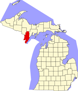
This is a list of the National Register of Historic Places listings in Leelanau County, Michigan.

National Register of Historic Places listings in Jackson County, Michigan

This is a list of the National Register of Historic Places listings in Jackson County, Michigan.

National Register of Historic Places listings in Menominee County, Michigan

This is a list of the National Register of Historic Places listings in Menominee County, Michigan.

National Register of Historic Places listings in Manistee County, Michigan

This is a list of the National Register of Historic Places listings in Manistee County, Michigan.

National Register of Historic Places listings in Mackinac County, Michigan

This is a list of the National Register of Historic Places listings in Mackinac County, Michigan.

National Register of Historic Places listings in Sanilac County, Michigan

This is a list of the National Register of Historic Places listings in Sanilac County, Michigan.

National Register of Historic Places listings in St. Joseph County, Indiana

This is a list of the National Register of Historic Places listings in St. Joseph County, Indiana.

National Register of Historic Places listings in Elkhart County, Indiana

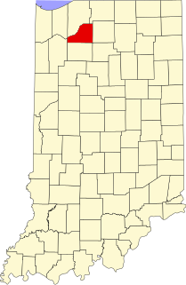
This is a list of the National Register of Historic Places listings in Elkhart County, Indiana.

National Register of Historic Places listings in LaPorte County, Indiana

This is a list of the National Register of Historic Places listings in LaPorte County, Indiana.

National Register of Historic Places listings in Marshall County, Indiana

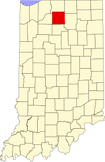
This is a list of the National Register of Historic Places listings in Marshall County, Indiana.

National Register of Historic Places listings in Starke County, Indiana

This is a list of the National Register of Historic Places listings in Starke County, Indiana.

National Register of Historic Places listings in Presque Isle County, Michigan

This is a list of the National Register of Historic Places listings in Presque Isle County, Michigan.

National Register of Historic Places listings in Gogebic County, Michigan

This is a list of the National Register of Historic Places listings in Gogebic County, Michigan.

National Register of Historic Places listings in Cass County, Michigan

This is a list of the National Register of Historic Places in Cass County, Michigan. This is intended to be a complete list of the properties and districts on the National Register of Historic Places in Berrien County, Michigan, United States. Latitude and longitude coordinates are provided for many National Register properties and districts; these locations may be seen together in a map.

National Register of Historic Places listings in Gratiot County, Michigan

This is a list of the National Register of Historic Places listings in Gratiot County, Michigan.

References

  1. The latitude and longitude information provided in this table was derived originally from the National Register Information System, which has been found to be fairly accurate for about 99% of listings. Some locations in this table may have been corrected to current GPS standards.
  2. National Park Service, United States Department of the Interior, "National Register of Historic Places: Weekly List Actions", retrieved July 30, 2021.
  3. Numbers represent an alphabetical ordering by significant words. Various colorings, defined here, differentiate National Historic Landmarks and historic districts from other NRHP buildings, structures, sites or objects.
  4. "National Register Information System". National Register of Historic Places . National Park Service. April 24, 2008.
  5. The eight-digit number below each date is the number assigned to each location in the National Register Information System database, which can be viewed by clicking the number.