
Lakeview is a town in Lake County, Oregon, United States. The population was 2,418 at the 2020 census. It is the county seat of Lake County. The city bills itself as the "Tallest Town in Oregon" because of its elevation, 4,757 feet (1,450 m) above sea level. Lakeview is situated in the Goose Lake Valley at the foot of the Warner Mountains and at the edge of Oregon's high desert country. Its economy is based on agriculture, lumber production, and government activities. In addition, tourism is an increasingly important part of the city's economy. Oregon's Outback Scenic Byway passes through Lakeview.

The Rogue River in southwestern Oregon in the United States flows about 215 miles (346 km) in a generally westward direction from the Cascade Range to the Pacific Ocean. Known for its salmon runs, whitewater rafting, and rugged scenery, it was one of the original eight rivers named in the Wild and Scenic Rivers Act of 1968. Beginning near Crater Lake, which occupies the caldera left by the explosive volcanic eruption and collapse of Mount Mazama, the river flows through the geologically young High Cascades and the older Western Cascades, another volcanic province. Further west, the river passes through multiple exotic terranes of the more ancient Klamath Mountains. In the Kalmiopsis Wilderness section of the Rogue basin are some of the world's best examples of rocks that form the Earth's mantle. Near the mouth of the river, the only dinosaur fragments ever discovered in Oregon were found in the Otter Point Formation, along the coast of Curry County.

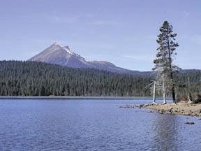
Bly is an unincorporated community in Klamath County, Oregon, United States. By highway, it is about 50 miles (80 km) east of Klamath Falls. As of 2020, the population was 207.
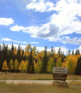
At 1.6 million acres the Kaibab National Forest borders both the north and south rims of the Grand Canyon, in north-central Arizona. It is divided into two major sections: the North Kaibab Ranger District and the South Kaibab and are managed by the United States Forest Service. The South Kaibab is further divided into two districts, the Tusayan Ranger District, and the Williams Ranger District. Grand Canyon National Park separates the North Kaibab and the South Kaibab. The South Kaibab covers 1,422 square miles (3,680 km2) and the North Kaibab stretches over 1,010 square miles (2,600 km2). Elevations vary on the forest from 5,500 feet in the southwest corner to 10,418 feet at the summit of Kendrick Peak on the Williams Ranger District. The forest as a whole is headquartered in Williams.

The Warner Valley Ranger Station, also known as the Warner Valley Patrol Cabin and Quarters 304, is located in the southern portion of Lassen Volcanic National Park, on the access road to the Drakesbad Guest Ranch. Built in 1926, it is unusual in its choice of construction method. While it resembles a log cabin, it was built using stacked milled 2x6 lumber to form the walls. It is the only such building known to have been built in this manner in the western regions of the National Park Service system. The interlocking boards extend past each other at the corners, forming a decorative detail.
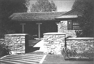
Munson Valley Historic District is the headquarters and main support area for Crater Lake National Park in southern Oregon. The National Park Service chose Munson Valley for the park headquarters because of its central location within the park. Because of the unique rustic architecture of the Munson Valley buildings and the surrounding park landscape, the area was listed as a historic district on the National Register of Historic Places (NRHP) in 1988. The district has eighteen contributing buildings, including the Crater Lake Superintendent's Residence which is a U.S. National Historic Landmark and separately listed on the NRHP. The district's NRHP listing was decreased in area in 1997.

Oregon Caves Historic District covers 6 acres (24,000 m2) in the main visitor area of Oregon Caves National Monument in southern Oregon. The district includes four primary buildings plus two other structures. Because of the unique rustic architecture of these National Park Service buildings and the surrounding park landscape, the area was listed on the National Register of Historic Places in 1992.

The Imnaha Guard Station is a rustic cabin located in the Rogue River-Siskiyou National Forest in western Oregon, United States. It was originally built to house fire crews assigned to patrol the surrounding National Forest. In the 1990s, the United States Forest Service began renting the Imnaha Guard Station to recreational visitors. The Imnaha Guard Station is listed on the National Register of Historic Places.

The Cabin Lake Guard Station is a Forest Service compound consisting of six simple rustic buildings located in the Deschutes National Forest in central Oregon. It was originally built as a district ranger station for the Fort Rock Ranger District. It was later converted to a summer guard station. The guard station is now closed, but the adjacent campground is open. While still very remote, it is a popular location for bird watching and nature photography. The Cabin Lake Guard Station is listed on the National Register of Historic Places.

Olallie Lake Guard Station is a former guard station in the Clackamas ranger district of the Mt. Hood National Forest, in Jefferson County, Oregon. Built in 1939, the cabin is in the Olallie Scenic Area near Olallie Butte and Mount Jefferson in the Cascade Mountains. It was listed on the National Register of Historic Places in 1991.

The Allison Guard Station is a Forest Service compound consisting of eight rustic buildings located in the Malheur National Forest in the Ochoco Mountains of eastern Oregon. It was originally built as a district ranger station for the Snow Mountain Ranger District. It was later converted to a summer guard station. Today, it is an active Forest Service guard station with a crew of twelve fire fighters on station during the summer fire season. The station's oldest building, the Donnelly Cabin, is currently listed on the National Register of Historic Places as the "Allison Ranger Station". Most of the other buildings at the Allison Guard Station are eligible for historic designation, but are not yet listed on the National Register.
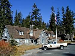
The Bly Ranger Station is a United States Forest Service compound that serves as the headquarters for the Bly Ranger District which is an administrative subdivision of the Fremont National Forest. It is located in the small unincorporated community of Bly in southcentral Oregon. The ranger station was constructed by the Civilian Conservation Corps between 1936 and 1942. Today, the seven original buildings are still used by the Bly Ranger District. The compound was listed on the National Register of Historic Places as a historic district in 1981.
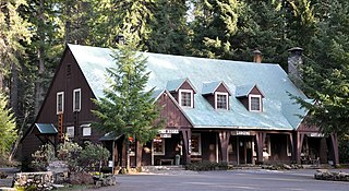
Union Creek Historic District near the upper Rogue River in Union Creek, Oregon, is listed on the U.S. National Register of Historic Places for rustic structures built by the Civilian Conservation Corps (CCC) in the 1930s. The site lies along Oregon Route 62 and the upper Rogue River, about 12 miles (19 km) north of Prospect and about 20 miles (32 km) west of Crater Lake.
Architects of the United States Forest Service are credited with the design of many buildings and other structures in National Forests. Some of these are listed on the National Register of Historic Places due to the significance of their architecture. A number of these architectural works are attributed to architectural groups within the Forest Service rather than to any individual architect. Architecture groups or sections were formed within engineering divisions of many of the regional offices of the Forest Service and developed regional styles.
Lake of the Woods is a natural lake near the crest of the Cascade Range in the Fremont–Winema National Forest in southern Oregon in the United States. The lake covers 1,146 acres (4.64 km2). It was named by Oliver C. Applegate in 1870. Today, the Oregon Department of Fish and Wildlife manages the lake's fishery. The small unincorporated community of Lake of the Woods is located on the east shore of the lake. Lake of the Woods is one of southern Oregon's most popular outdoor recreation sites.

The Lake of the Woods Ranger Station is a United States Forest Service compound consisting of eight buildings overlooking Lake of the Woods in the Fremont-Winema National Forests of southern Oregon. All of the ranger station structures were built by the Civilian Conservation Corps between 1937 and 1939. Today, the compound serves as a Forest Service work center, and the old ranger station office is a visitor center. The ranger station is listed on the National Register of Historic Places.
Architects of the National Park Service are the architects and landscape architects who were employed by the National Park Service (NPS) starting in 1918 to design buildings, structures, roads, trails and other features in the United States National Parks. Many of their works are listed on the National Register of Historic Places, and a number have also been designated as National Historic Landmarks.
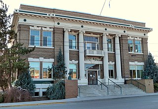
Klamath Falls City Hall is a city hall building in Klamath Falls, Oregon, in the United States. It was built in 1914 and added to the National Register of Historic Places on October 30, 1989.

The Elk Lake Guard Station is a United States Forest Service cabin located in the Deschutes National Forest southwest of Bend, Oregon. The guard station was built in 1929 on the north shore of Elk Lake. It was used as a home base for Forest Service personnel who protected forest resources, maintained facilities, and aided summer visitors in the Cascade Lakes area of Central Oregon. After decades of use, the cabin was renovated in the late 1990s. Today, the historic guard station serves as a Forest Service visitor information center along the Cascade Lakes Scenic Byway. The Elk Lake Guard Station is listed on the National Register of Historic Places.

The Whaleback Snow-Survey Cabin, about 10 miles (16 km) north of Prospect in the Rogue River–Siskiyou National Forest in southwest Oregon, is a log cabin with a "snow tower" built in 1937. It is situated on the east slope of Whaleback Mountain. It was listed on the National Register of Historic Places in 2000.


