Pulaski County is a county located in the U.S. state of Missouri. As of the 2020 census, the population was 53,955. Its county seat is Waynesville. The county was organized in 1833 and named for Kazimierz Pułaski, a Polish patriot who died fighting in the American Revolution.

Laclede County is a county located in the U.S. state of Missouri. As of the 2020 census, the population was 36,039. Its county seat is Lebanon. The county was organized February 24, 1849, and was named after Pierre Laclède, founder of St. Louis.

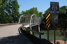
Devils Elbow is an unincorporated community in Pulaski County, Missouri, United States on historic U.S. Highway 66. It is situated on the Big Piney River and is named for a tight incised meander in the river known as a "devil of an elbow". The community is approximately five miles (8 km) east of St. Robert.

Hazelgreen is an unincorporated community in eastern Laclede County, Missouri, United States. It lies along historic U.S. Route 66, now an outer road of Interstate 44. The town is split by I-44, one mile west of the I-44 - Missouri Route 133 junction in adjacent Pulaski County. The Gasconade River is just north and west of the site.
Gascozark is an unincorporated community in western Pulaski County, Missouri, United States. The town site is on Missouri Supplemental Route AB.

Buckhorn is a community in Pulaski County, Missouri, United States. It is on Route 17 just south of its junction with Interstate 44 It is also on historic U.S. Route 66. The community is within the Mark Twain National Forest and the northwest corner of Fort Leonard Wood is three miles to the east. Waynesville is six miles to the northeast along Route 44 and Laquey is two miles to the southwest off of Route 17.
Big Piney is an unincorporated community in Pulaski County, Missouri, United States on the southeastern edge of Fort Leonard Wood and one mile west of a bend in the Big Piney River. The community is on Missouri Route TT four miles northeast of Palace. Licking is seventeen miles to the southeast. Its former K-8 school has closed; students attend the Plato R-V School District.

Laquey is an unincorporated community in Pulaski County, Missouri, United States. It has Zip Code: 65534 and Area Code: 573.
Fort Leonard Wood is a U.S. Army training installation located in the Missouri Ozarks. The main gate is located on the southern boundary of The City of St. Robert. The post was created in December 1940 and named in honor of General Leonard Wood in January 1941. Originally intended to train infantry troops, in 1941 it became an engineer training post with the creation of the Engineer Replacement Training Center. During World War II Italian and German POWs were interned at the fort. In 1984, as part of the Base Realignment and Closure process, most of the U.S. Army Engineer School's operations were consolidated at Fort Leonard Wood. Before that, officer training was conducted at Fort Belvoir, Virginia.
Bloodland is a former community in southern Pulaski County, Missouri, United States. The community lies within Ft. Leonard Wood. The location is about 3.5 miles west-northwest of the community of Big Piney which sits adjacent to the east boundary of the Fort Leonard Wood and 4.5 miles north of the community of Palace, which is just outside the southern boundary of Fort Leonard Wood.
Cookville is an extinct town in southwestern Pulaski County, in the U.S. state of Missouri. The GNIS classifies it as a populated place. The town site is along Roubidoux Creek within the southern part of Fort Leonard Wood. The community of Greenview is located two miles to the west on Missouri Route 17 along the western boundary of the military reservation and adjacent to the Pulaski-Laclede county line.
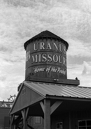
Uranus is a tourist attraction in unincorporated rural Pulaski County, Missouri, United States, along the former U.S. Route 66 (US 66). All businesses are owned by Louie Keen, who calls himself the "Mayor of Uranus".
Brownfield is an unincorporated community in northeastern Laclede County, in the U.S. state of Missouri. The community is located just over one mile southeast of the Laclede-Pulaski county line and one mile east of Missouri Route K. It is within the Mark Twain National Forest and the Gasconade River lies just one mile to the east.
Spring Creek is an extinct town in Phelps County, in the U.S. state of Missouri. The GNIS classifies it as a populated place. The community is on the southwest side of the confluence of Spring Creek and the Big Piney River. The site is on the Phelps-Pulaski county line. The Wayman/Pillman cemetery is west of the county line in Pulaski County. The boundary of Fort Leonard Wood is two miles to the west, along Missouri Route J, which passes through the community.
Franks is an unincorporated community in Pulaski County, in the U.S. state of Missouri.
Hanna is a former community in southwestern Pulaski County, in the U.S. state of Missouri.
Helm is an unincorporated community in northeast Pulaski County, in the U.S. state of Missouri. The community is located adjacent to Missouri Route N, just south of Missouri Route 133, between Dixon and Crocker.
Palace is an unincorporated community in southern Pulaski County, in the U.S. state of Missouri. The community is located on Missouri Route AW, just southeast of the Fort Leonard Wood boundary. The community of Evening Shade lies approximately three miles south on Route AW in Texas County.
Saint John is an unincorporated community in western Pulaski County, in the U.S. state of Missouri. The community is located on Missouri Route 133 between Richland to the southwest and Swedeborg to the northeast.
Edanville is an extinct town in northern Texas County, in the U.S. state of Missouri. The GNIS classifies it as a populated place.