Hoon, Derbyshire

Last updated

Hoon
Civil parish
Hoon Mount - geograph.org.uk - 888500.jpg
Hoon Mount, a burial mound
Hoon, Derbyshire
Parish map
Derbyshire UK location map.svg
Red pog.svg
Hoon
Location within Derbyshire
Area1.21 sq mi (3.1 km2)  [1]
Population55 (2021) [2]
  Density 45/sq mi (17/km2)
OS grid reference SK227310
  London 110 mi (180 km)  SE
District
Shire county
Region
Country England
Sovereign state United Kingdom
Post town DERBY
Postcode district DE65
Dialling code 01283
Police Derbyshire
Fire Derbyshire
Ambulance East Midlands
UK Parliament
List of places
UK
England
Derbyshire
52°52′34″N1°39′47″W / 52.876°N 1.663°W / 52.876; -1.663

Hoon is a hamlet and civil parish within the South Derbyshire district, which is in the county of Derbyshire, England. It is a predominantly rural area with few residences or farms, and had a population of 55 residents in 2021. [2] [3] The parish is 110 miles (180 km) north west of London, 8 miles (13 km) south west of the county city of Derby, and 5 miles (8.0 km) north of the nearest market town of Burton-on-Trent in Staffordshire. It shares a border with the parishes of Church Broughton, Hatton, Hilton, Marston on Dove, Sutton on the Hill, as well as Tutbury. [4]

Contents

Geography

Location

Hoon is surrounded by the following local locations: [4]

It is 1.21 square miles (3.1 km2; 310 ha) in area, [1] 2+12 miles (4.0 km) in height and 1+13 miles (2.1 km) in width with an elongated shape, within the north western part of the South Derbyshire district, and south west within Derbyshire county. The parish is roughly bounded by land features such as the Limbersitch and Sutton brooks to the north, Sutton Lane and waste processing works to the west, Hoon Ridge to the east, and the River Dove to the south.

Settlements and routes

There are seven farms and residences, all prefixed 'Hoon'. Most are to the north of the parish, centred around the Hoon Ridge country house, with Hoon Hay Manor, a farm in the south. Outside of these scattered settlements, the parish is predominantly an agricultural and rural area.

There are four roads, the first two traversing cross-parish on an east-to-west alignment – the A50 trunk route which has no turnoffs within the parish; and the unnumbered Derby Road between the A5111 and Hilton village. The third, Hoon Lane is the only vehicular route into the core hamlet area from Derby Road. The northern boundary by Limbersitch Brook cuts briefly across Limbersitch Lane, which heads southbound towards neighbouring Hatton.

Environment

Landscape

Primarily farming and pasture land throughout the parish outside the sparsely populated areas, there is little forestry throughout, mainly surrounding residences. The northern parish area is part of the South Derbyshire Claylands, with riverside meadows around Sutton Brook; [5] the southern portion of Hoon below the A50 is classed as the Trent Valley Washlands, also with some riverside meadows. [6]

Geology

Along the River Dove there are superficial deposits of alluvium comprising gravel, sand, silt and clay, being formed between 11,000 years ago and the present. [7] In the middle of the area, the bedrock is from the Mercia Mudstone Group formed between 252.2 and 201.3 million years ago during the Triassic period. North of the parish by the Sutton Brook, there are superficial glaciofluvial terrace deposits, of the Mid Pleistocene transition composed of sand and gravel, these being formed between 860 and 116 thousand years ago during the Quaternary period.

Hydrological features

The parish rests between the River Dove forming the south boundary, and the Sutton and Limbersitch brooks in the north near the upper boundary. Salt Brook forms some of the south west boundary. There is an unnamed brook flowing from west to east in the middle of the area, eventually feeding into the Hilton Brook. There are a number of ponds alongside this and the Sutton Brook. Hoon Hay Lake is a small still water fishery in the south of about 6 acres, close to Hoon Hay Farm. [8]

Land elevation

The parish is generally low-lying. Points around the River Dove begin at ~50 metres (160 ft), remaining as such until north of the A50 road, when the parish rises along a ridge to a peak near the hamlet, with the tumulus by Hoon Mount at 82 metres (269 ft), before falling off to 60 metres (200 ft) along the northern boundary. [9]

History

Toponymy

Hoon was noted in the 1086 Domesday Survey as Hougen, meaning 'at the barrows'. [10]

Heritage

Although the name of Hoon suggests several, there is only one known tumulus in the parish, at Hoon Mount. These date typically from the Bronze Age – 2350 BC to 701 BC. It appears to have been disturbed at a later unknown date. [11] Iron Age (800BC to 409AD) remnants include field boundary evidence, [12] and various examples of medieval 'ridge and furrow' farming found throughout. [13] [14] During an unknown medieval period, it is thought there was a village near Hoon Hay in the south, considered to be later depopulated. [15] [16] At the time of the Domesday survey in 1086 Hoon had two manors; one owned by Burton Abbey, after the Dissolution of the monasteries this was granted along with other lands by Henry VIII to Sir William Paget, which descended through marriage to the Scholfield family into the 20th century; [17] [18] [19] the other appears to be Hoon Hay manor, [20] which came under the ownership of Henry de Ferrers and was held by Saswalo (alias Sewallis), whose descendants took on the surname Shirley from Shirley, Derbyshire where they had their seat.

The manor remained with the Shirley family until the reign of Henry VIII. It was bought after this by the Palmers, who were succeeded by the Staffords. In the middle of the 17th century it was purchased by a member of the Pye baronets, John Pye, and in 1734 the last of the baronets, Sir Robert Pye died with the manor descended to his three daughters, and it was later owned by the Watkins family. [20] In the early 19th century this portion of Hoon appears to have been sold by Captain Watkins to Mr W.J. Lockett, who then divided up and sold the landholdings. [21] [22] The North Staffordshire Railway built the Crewe-Derby Line across the south of the parish in 1848. [23] Hoon was a township within the ancient parish of Marston-on-Dove, but became a civil parish after 1866. [24] The Nestle coffee processing plant has been historically based in neighbouring Hatton since the beginning of the 20th century, but from 2012 it expanded into the south west area of Hoon parish, the extension being officially opened in 2016. [25]

Governance and demography

Population

There are 55 residents recorded within Hoon in the 2021 census. [2]

Local bodies

Hoon parish is managed at the first level of public administration through a parish meeting. Although there is a ward on the neighbouring Hatton parish council named for Hoon, it is not within Hoon parish. [26] The local development plan however is arranged in conjunction with the Marston-on-Dove and Hilton parishes. [9]

At district level, the wider area is overseen by South Derbyshire district council. Derbyshire County Council provides the highest level strategic services locally.

Economy

The present business sector types other than agriculture in the parish are few due to being a low populated area, with these employment areas including:

Community and leisure

Primarily rural and agricultural means there are no publicly accessible amenities within the parish. Any basic needs require a visit to the nearby villages of Hatton, Hilton or Tutbury.

Hoon Hay Lake is a small still water fishery of about 6 acres close to Hoon Hay manor. It is managed by a local angling club. [8]

Landmarks

Ordnance Survey's triangulation pillar with placard on Hoon Mount Plaque, Hoon Mount - geograph.org.uk - 888504.jpg
Ordnance Survey's triangulation pillar with placard on Hoon Mount

Listed sites

There is one residential location of architectural merit throughout the parish with statutory listed status at Grade II, Hoon Ridge, it was built in 1907 as an Arts & Crafts styled mansion, designed by the architect George Morley Eaton, a follower of Sir Edwin Lutyens. [28]

Scheduled monument

Hoon Mount is the location of a tumulus which has protected status. [11] There is a path from the hamlet that leads to it, which has a triangulation pillar on top built in 1939, [29] with a commemorative plaque installed in 2001.

Tourism

The Salt Brook Heritage Trail runs through the south of the parish from Marston on Dove to Hatton and round the perimeter of the Nestle plant, highlighting the legacy of the local area with sculptures and history boards, it was opened in 2018. The National Cycling Network Route 549 follows the same path. [30]

Notable people

See also

Related Research Articles

<span class="mw-page-title-main">East Staffordshire</span> Non-metropolitan district and Borough in England

East Staffordshire is a local government district with borough status in Staffordshire, England. The council is based in Burton upon Trent. The borough also contains the town of Uttoxeter and numerous villages and surrounding rural areas.

<span class="mw-page-title-main">South Derbyshire</span> Non-metropolitan district in England

South Derbyshire is a local government district in Derbyshire, England. The district covers the towns of Melbourne and Swadlincote as well as numerous villages and hamlets such as Hilton, Hatton, Etwall, Aston-on-Trent, Repton, Weston-on-Trent and Willington. About a third of the National Forest lies within the district.

<span class="mw-page-title-main">Tutbury</span> Human settlement in England

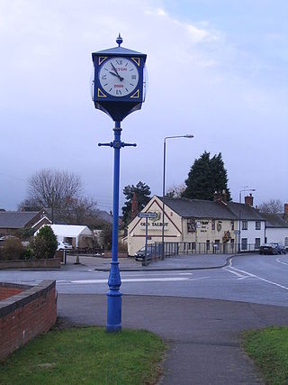
Tutbury is a village and civil parish in Staffordshire, England. It is 4 miles (6.4 km) north of Burton upon Trent and 20 miles (32 km) south of the Peak District. The village has a population of about 3,076 residents. It adjoins Hatton to the north on the Staffordshire–Derbyshire border.

<span class="mw-page-title-main">Willington, Derbyshire</span> Human settlement in England

Willington is a town and civil parish in the South Derbyshire district of Derbyshire, England. The 2001 Census recorded a parish population of 2,604, increasing to 2,864 at the 2011 Census.

<span class="mw-page-title-main">River Dove, central England</span> River in Derbyshire and Staffordshire, England

The River Dove is the principal river of the southwestern Peak District, in the Midlands of England, and is around 45 miles (72 km) in length. It rises on Axe Edge Moor near Buxton and flows generally south to its confluence with the River Trent at Newton Solney. From there, its waters reach the North Sea via the Humber Estuary. For almost its entire course it forms the boundary between the counties of Staffordshire and Derbyshire. The river meanders past Longnor and Hartington and cuts through a set of deep limestone gorges, Beresford Dale, Wolfscote Dale, Milldale and Dovedale.

<span class="mw-page-title-main">Doveridge</span> Human settlement in England

Doveridge is a village and civil parish in Derbyshire, United Kingdom, near the border with Staffordshire and about 2 km (1.2 mi) east of Uttoxeter. Its name may come from its having a bridge over the river Dove, a tributary of the River Trent. The civil parish population as taken at the 2011 Census was 1,622.

<span class="mw-page-title-main">Hatton, Derbyshire</span> Human settlement in England

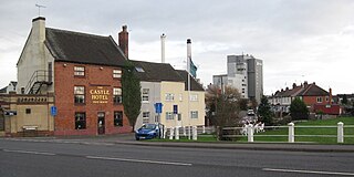
Hatton is a village and civil parish in South Derbyshire, England. It is 5 miles (8.0 km) north of Burton upon Trent, 10 miles (16 km) south-west of Derby and 24 miles (39 km) south-east of Stoke-on-Trent. The population of the civil parish as of the 2011 census was 2,785. It adjoins Tutbury to the south.

<span class="mw-page-title-main">Hilton, Derbyshire</span> Human settlement in England

Hilton is a village and civil parish in the South Derbyshire district of Derbyshire, England. The population at the 2011 Census was 7,714.

<span class="mw-page-title-main">Sutton on the Hill</span> Human settlement in England

Sutton-on-the-Hill is a parish in south Derbyshire eight miles (13 km) west of Derby. The population of the civil parish taken at the 2011 Census was 123. The village is widely spread out and contains both a church and a chapel. It was described as "a parish, with two townships and a hamlet" in the 1870s. Now it has no shop or post office and limited public transport links. Sutton on the Hill is primarily an agricultural area with former dairy farms at either end of the village, along with the Sutton Estate Farm. The village school has been converted into a village hall and has a nursery school for the local villages.

<span class="mw-page-title-main">John Port Spencer Academy</span> Academy in Etwall, Derbyshire, England

John Port Spencer Academy, formerly known as John Port School, is an academy and secondary school in the village of Etwall, Derbyshire, England.

Foston is a hamlet in the Foston and Scropton civil parish of South Derbyshire, Derbyshire, England, about 12 miles (19 km) west of Derby and 8 miles (13 km) east of Uttoxeter. The Domesday Book of 1086 lists it as Farulveston.

<span class="mw-page-title-main">Marston on Dove</span> Village in Derbyshire, England

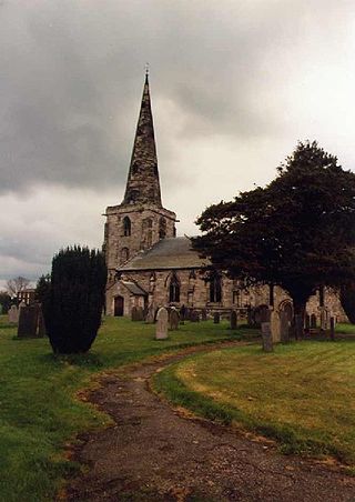
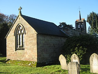
Marston on Dove is a village and civil parish in South Derbyshire, nine miles (14 km) south west of Derby and two miles (3.2 km) east of Tutbury. The Church of St Mary at Marston has the oldest bell in Derbyshire, which was cast in Leicester in 1366 and inscribed with the words "Hail Mary" by John de Stafford.

<span class="mw-page-title-main">Hilton Brook</span> River in England

The Hilton Brook or Sutton Brook is a tributary of the River Dove in Derbyshire, England, and is 26 kilometres long. Like many watercourses in the area, it has multiple names, often being named locally after the village it flows past.

The Hundreds of Derbyshire were the geographic divisions of the historic county of Derbyshire for administrative, military and judicial purposes. They were established in Derbyshire some time before the Norman conquest. In the Domesday Survey of 1086 AD the hundreds were called wapentakes. By 1273 the county was divided into 8 hundreds with some later combined, becoming 6 hundreds over the following centuries. The Local Government Act 1894 replaced hundreds with districts. Derbyshire is now divided into 8 administrative boroughs within the Derbyshire County Council area.

<span class="mw-page-title-main">Hartington Middle Quarter</span> Civil parish in Derbyshire, England

Hartington Middle Quarter is a civil parish within the Derbyshire Dales district, which is in the county of Derbyshire, England. Formerly a part of Hartington parish, for which it is named, it has a mix of a number of villages and hamlets amongst a mainly rural and undulating landscape, and is wholly within the Peak District National Park. It had a population of 379 residents in 2011. The parish is 130 miles (210 km) north west of London, 20 miles (32 km) north west of the county city of Derby, and 5 miles (8.0 km) south east of the nearest market town of Buxton. Being on the edge of the county border, it shares a boundary with the parishes of Chelmorton, Flagg, Hartington Town Quarter, Hartington Upper Quarter, Middleton and Smerrill, Monyash in Derbyshire, as well as Hollinsclough, Longnor and Sheen in Staffordshire.

<span class="mw-page-title-main">Clifton and Compton</span> Civil parish in Derbyshire, England

Clifton and Compton is a civil parish within the Derbyshire Dales district, in the county of Derbyshire, England. The parish, despite the name, only includes the villages of Clifton and Hangingbridge. In 2011 the parish had a population of 500. It is 124 miles (200 km) north west of London, 13 miles (21 km) north west of the county city of Derby, and 1+13 miles south west of the market town of Ashbourne. Clifton and Compton touches the parishes of Ashbourne, Edlaston and Wyaston, Mayfield, Offcote and Underwood, Osmaston, Okeover and Snelston. There are eight listed buildings in Clifton and Compton.

<span class="mw-page-title-main">Edlaston and Wyaston</span> Civil parish in Derbyshire, England

Edlaston and Wyaston is a civil parish within the Derbyshire Dales district, in the county of Derbyshire, England. The parish includes the villages of Edlaston and Wyaston. In 2011 the parish had a population of 220, which increased to 241 in the census of 2021. It is 120 miles (190 km) north west of London, 11 miles (18 km) north west of the county city of Derby, and 2+12 miles (4 km) south of the market town of Ashbourne. Edlaston and Wyaston touches the parishes of Clifton and Compton, Osmaston, Rodsley, Shirley, Snelston and Yeaveley. There are seven listed buildings in Edlaston and Wyaston.

<span class="mw-page-title-main">Offcote and Underwood</span> Civil parish in Derbyshire, England

Offcote and Underwood is a civil parish within the Derbyshire Dales district, in the county of Derbyshire, England. Largely rural, in 2011 the parish had a population of 526. It is 125 miles (201 km) north west of London, 13 miles (21 km) north west of the county city of Derby, and 1 mile north east of the market town of Ashbourne. Offcote and Underwood borders the Peak District, and touches the parishes of Ashbourne, Bradley, Clifton and Compton, Fenny Bentley, Kniveton, Mapleton and Okeover. There are 12 listed buildings in Offcote and Underwood.

References

  1. 1 2 "Hoon". ONS.
  2. 1 2 3 UK Census (2021). "2021 Census Area Profile – Hoon parish (E04002907)". Nomis. Office for National Statistics . Retrieved 6 January 2024.
  3. UK Census (2011). "Local Area Report – Hatton and Hoon parishes (E04002907)". Nomis. Office for National Statistics . Retrieved 15 January 2022.
  4. 1 2 "Hoon". Ordnance Survey.
  5. "Landscape character of Derbyshire – Part One: Landscape Character Descriptions – 6. Needwood and South Derbyshire Claylands" (PDF).
  6. "Landscape character of Derbyshire.- Part One: Landscape Character Descriptions – 7. Trent Valley Washlands" (PDF).
  7. "Derbyshire County Council – Part One: Landscape Character Descriptions – 4. Nottinghamshire, Derbyshire and Yorkshire Coalfield – LANDSCAPE TYPE: COALFIELD VILLAGE FARMLAND" (PDF).
  8. 1 2 "DCAC Fly Only Waters". derbyshirecountyac.org. Retrieved 15 January 2022.
  9. 1 2 "Neighbourhood Plan". www.hiltonparishcouncil.org.uk. 25 August 2022. Retrieved 6 January 2024.
  10. "Hoon :: Survey of English Place-Names". University of Nottingham. Retrieved 8 January 2022.
  11. 1 2 "MDR2667 – Hoon Mount – Platform Bowl Barrow – Derbyshire Historic Environment Record". her.derbyshire.gov.uk. Retrieved 9 January 2022.
  12. "MDR14533 – Field boundary (site of), south of Derby Road, Hoon – Derbyshire Historic Environment Record". her.derbyshire.gov.uk. Retrieved 9 January 2022.
  13. "MDR15774 – Ridge and furrow, Hoon Mount Farm, Hoon – Derbyshire Historic Environment Record". her.derbyshire.gov.uk. Retrieved 9 January 2022.
  14. "MDR14583 – Ridge and furrow, Hoon Ridge Villa, Hoon – Derbyshire Historic Environment Record". her.derbyshire.gov.uk. Retrieved 9 January 2022.
  15. "MDR2659 - Possible deserted medieval village, Hoon - Derbyshire Historic Environment Record". her.derbyshire.gov.uk. Retrieved 6 January 2024.
  16. "Beresford's Lost Villages :: Site detail :: Hoon". dmvhull.org. Retrieved 14 January 2022.
  17. "1847 Tithe Map & Apportionment of Hoon in Marston upon Dove, Derbyshire, sorted by Occupier". freepages.rootsweb.com. Retrieved 14 January 2022.
  18. Lease and deed to bar entail relating to property in Hoon in Derbyshire and Staffordshire. 18 May 1836.
  19. "CalmView: Record". eastriding.gov.uk. Retrieved 14 January 2022.
  20. 1 2 Hoon. The manor and all appurtenances.(Pye/trustees).1680.Hoon. 1680–1709.
  21. Lysons, Daniel; Lysons, Samuel (1817). Magna Britannia: Volume 5: Derbyshire. pp. 205–206.
  22. Bulmer, T. (1895). The History, Topography and Directory of Derbyshire. p. 410.
  23. "Burton on Trent Local History » Station History" . Retrieved 15 January 2022.
  24. GENUKI. "Genuki". genuki.org.uk. Retrieved 14 January 2022.
  25. "UK Secretary of State officially opens Nestlé Tutbury factory". Comunicaffe International. 11 March 2016. Retrieved 15 January 2022.
  26. "The Parish Council – Hatton Parish Council" . Retrieved 9 January 2022.
  27. "JB Alloys" . Retrieved 9 January 2022 via Facebook. [self-published]
  28. Historic England. "HOON RIDGE, Hoon (1205285)". National Heritage List for England . Retrieved 9 January 2022.
  29. "T:UK – Hoon Mount". trigpointing.uk. Retrieved 10 January 2022.
  30. "Take a step back in time with the Salt Brook Heritage Trail". South Derbyshire District Council. Retrieved 9 January 2022.
  31. "DustyDocs – English Parish Registers Online". dustydocs.com. Retrieved 10 January 2022.
  32. "Page 1214 | Issue 37905, 14 March 1947 | London Gazette | The Gazette". www.thegazette.co.uk. Retrieved 10 January 2022.