Glossop is a market town in the borough of High Peak, Derbyshire, England, 15 miles (24 km) east of Manchester, 24 miles (39 km) north-west of Sheffield and 32 miles (51 km) north of Matlock. Near Derbyshire's borders with Cheshire, Greater Manchester, South Yorkshire and West Yorkshire, between 150 and 300 metres above sea level, it is bounded by the Peak District National Park to the south, east and north. In 2021, it had a population of 17,825.

The Derwent is a river in Derbyshire, England. It is 50 miles (80 km) long and is a tributary of the River Trent, which it joins south of Derby. Throughout its course, the river mostly flows through the Peak District and its foothills.

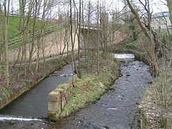
The River Etherow in northern England is a tributary of the River Goyt. Although now passing through South Yorkshire, Derbyshire and Greater Manchester, it historically formed the ancient county boundary between Cheshire and Derbyshire. The upper valley is known as Longdendale. The river has a watershed of approximately 30 square miles (78 km2), and the area an annual rainfall of 52.5 inches (1,330 mm).

The River Goyt is a tributary of the River Mersey in North West England.

The Upper Goyt Valley is the southern section of the valley of the River Goyt in North West England.
The River Dane is a tributary of the River Weaver that originates in the Peak District area of England. The name of the river is probably from the Old Welsh dafn, meaning a "drop or trickle", implying a slow-moving river.

The River Noe is a tributary of the River Derwent in Derbyshire, England. It flows approximately 12 miles (19 km) from its source, the confluence of two streams running off Kinder Scout in the Peak District, east through Edale and then southeast through the village of Hope.
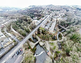
New Mills is a town in the Borough of High Peak, Derbyshire, England, 8 miles (13 km) south-east of Stockport and 13 miles (21 km) from Manchester at the confluence of the River Goyt and Sett. It is close to the border with Cheshire and above the Torrs, a 70 feet (21 m) deep gorge cut through carboniferous sandstone, on the north-western edge of the Peak District National Park.

The River Tame flows through Greater Manchester, England. It rises on Denshaw Moor and flows to Stockport where it joins the River Goyt to form the River Mersey.

Kinder Scout is a moorland plateau and National Nature Reserve in the Dark Peak of the Derbyshire Peak District in England. Part of the moor, at 636 metres (2,087 ft) above sea level, is the highest point in the Peak District, in Derbyshire and the East Midlands.

The River Bollin is a major tributary of the River Mersey in the north-west of England.

Hayfield is a village and civil parish in High Peak, Derbyshire, England, with a population of around 2,700. The village is 3 miles (4.8 km) east of New Mills, 4.5 miles (7.2 km) south of Glossop and 10 miles (16 km) north of Buxton, in the basin of the River Sett.

Birch Vale is a village in the High Peak district of Derbyshire, just outside the boundary of the Peak District National Park, between New Mills and Hayfield. Most of Birch Vale, including the attached hamlet of Thornsett, comes under the administration of New Mills Town Council, though the small part to the east of the former Grouse Inn public house is within the boundaries of Hayfield.
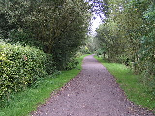
The Sett Valley Trail is a 2.5-mile (4.0 km) shared-use path in Derbyshire, England, linking the village of Hayfield and the town of New Mills, via Birch Vale, Thornsett and Ollersett. It runs along the lower valley of the River Sett on the route of a former railway line.

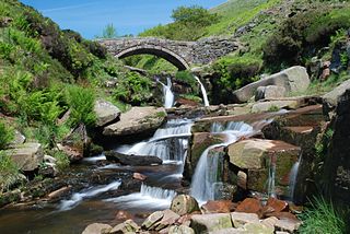
The River Kinder is a small river, only about 3 miles (4.8 km) long, in northwestern Derbyshire, England. Rising on the peat moorland plateau of Kinder Scout, it flows generally westwards to its confluence with the River Sett at Bowden Bridge. En route it flows through the Kinder Gates rocks, over the waterfall known as Kinder Downfall, and through Kinder Reservoir, built in 1903–12 by the Stockport Corporation Water Works. Until the 19th century at least, the name was formerly also applied to the River Sett as far as its confluence with the River Goyt in New Mills.

Thornsett is a hamlet within the civil parish of New Mills in Derbyshire. It lies between New Mills and Hayfield, and features a primary school, a nursery, two pubs, a band room and a cemetery. It is roughly 13 miles (21 km) southeast of central Manchester and 22 miles (35 km) west of Sheffield. The hamlet is governed by High Peak Borough Council and, as it lies within New Mills' parish boundaries, New Mills Town Council.

The Hayfield Branch was a 2+1⁄2-mile (4 km) single-track branch line that ran along the Sett Valley from the Hope Valley Line near New Mills Central to Hayfield, via one intermediate stop, Birch Vale. It passed under the town of New Mills through the 180 m (200 yd) rock-cut Hayfield tunnel.
The Peak District Boundary Walk is a circular 190-mile (310 km) walking trail, starting and finishing at Buxton and broadly following the boundary of the Peak District, Britain's first national park. The route was developed by the Friends of the Peak District and was launched on 17 June 2017.

The Vale of Edale is the upper valley of the River Noe, in the Derbyshire Peak District of England. The village of Edale lies in the middle of the valley.

Birch Vale railway station served the village of Birch Vale, Derbyshire, England. It was a stop on the Hayfield branch between New Mills Central and Hayfield between 1868 and 1970.