Ashopton

Last updated

Ashopton
Ashopton Viaduct Arches - photoshopped 559803.jpg
The Ashopton Viaduct arches
Derbyshire UK location map.svg
Red pog.svg
Ashopton
Location within Derbyshire
Population0 
OS grid reference SK1986
District
Shire county
Region
Country England
Sovereign state United Kingdom
Post town HOPE VALLEY
Postcode district S33
Dialling code 01433
Police Derbyshire
Fire Derbyshire
Ambulance East Midlands
UK Parliament
List of places
UK
England
Derbyshire
53°22′N1°43′W / 53.37°N 01.71°W / 53.37; -01.71 Coordinates: 53°22′N1°43′W / 53.37°N 01.71°W / 53.37; -01.71

Ashopton was a small village in Derbyshire, England, in the valley of the River Ashop. The village population was less than 100. Details are included in the civil parish of Aston, Derbyshire. In the early 1940s, the village (along with neighbouring Derwent) was demolished to make way for the filling of Ladybower Reservoir.

Contents

History

The village was in the chapelry of Derwent. In 1829, Stephen Glover wrote that the village hosted a wool fair on 29 July; he suggested that this was intended to be a tradition continued annually on the last Wednesday of July. [1]

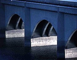
The village was located near where the Derwent Valley joins the Snake Valley (route of the current A57 Snake Pass to Glossop). There are several reminders of the village. One is in the name of the Ashopton Viaduct which carries the A57 across the mouth of the Derwent Valley. The main part of the village was immediately south of the viaduct. Other reminders of the village include Ashopton Sawmill and Ashopton Cottage.

Unlike the remains of Derwent village, which have become visible when water levels have dropped, Ashopton will never re-emerge from the waters of Ladybower as silt has already covered the remains of its buildings.

A key part of the village was the Methodist Chapel, built in 1840. The final service was held at the chapel on 25 September 1939. [2] The final hymn sung was "The Day's Dying in the West". The chapel was finally demolished, along with the remaining buildings in the village, in 1943.

The Derwent Valley Museum, was located in the western tower of the Derwent Reservoir dam wall and run privately by the late Vic Hallam. It told the history of the Derwent valley and of Derwent and Ashopton as well as the tale of RAF Squadron 617 and its training for Operation Chastise during the Second World War. [3] The museum has now closed. [4]

Related Research Articles

<span class="mw-page-title-main">Glossop</span> Town in the High Peak, Derbyshire, England

Glossop is a market town in the Borough of High Peak, Derbyshire, England. It is located 15 miles (24 km) east of Manchester, 24 miles (39 km) north-west of Sheffield and 32 miles (51 km) north of the county town, Matlock. Glossop lies near Derbyshire's borders with Cheshire, Greater Manchester, South Yorkshire and West Yorkshire. It is between 150 and 300 metres above sea level and is bounded by the Peak District National Park to the south, east and north.

The Upper Derwent Valley is an area of the Peak District National Park in England. It largely lies in Derbyshire, but its north eastern area lies in Sheffield, South Yorkshire. Its most significant features are the Derwent Dams, Ladybower, Derwent and Howden, which form Ladybower Reservoir, Derwent Reservoir and Howden Reservoir respectively.

<span class="mw-page-title-main">River Derwent, Derbyshire</span> River in Derbyshire, England

The Derwent is a river in Derbyshire, England. It is 50 miles (80 km) long and is a tributary of the River Trent, which it joins south of Derby. Throughout its course, the river mostly flows through the Peak District and its foothills.

<span class="mw-page-title-main">Birchinlee</span> Human settlement in England

Birchinlee is the site of "Tin Town", a village built by the Derwent Valley Water Board for the workers who constructed the Derwent and Howden Dams between 1902 and 1916. Most of the workers had previously been engaged in the construction, in Wales, of the Elan Valley Reservoirs where the accommodation was very basic. At Birchinlee, a "model village" was built; its infrastructure included hospitals, school, canteen (pub), post office, shops, recreation hall, public bath house, police station, railway station, rubbish dump with incinerator, and much else. One of the shops was a well-stocked store owned by the Gregory brothers from Tideswell. Accommodation consisted of workmen's huts, foremen's huts and married workmen's huts. The latter were decorated to a high standard, as photographs from the period confirm. The population rose to 900 people.

<span class="mw-page-title-main">Derwent Reservoir (Derbyshire)</span> Reservoir in Derbyshire, England

Derwent Reservoir is the middle of three reservoirs in the Upper Derwent Valley in the north of Derbyshire, England. It lies approximately 10 mi (16 km) from Glossop and 10 mi (16 km) from Sheffield. The River Derwent flows first through Howden Reservoir, then Derwent Reservoir and finally through Ladybower Reservoir. Between them they provide practically all of Derbyshire's water, as well as to a large part of South Yorkshire and as far afield as Nottingham and Leicester.

<span class="mw-page-title-main">Howden Reservoir</span> Reservoir in the Peak District, England

The Howden Reservoir is a Y-shaped reservoir, the uppermost of the three in the Upper Derwent Valley, England. The western half of the reservoir lies in Derbyshire and the eastern half is in Sheffield, South Yorkshire; the county border runs through the middle of the reservoir, following the original path of the River Derwent. The longest arm is around 1+14 mi (2.0 km) in length. The reservoir is bounded at the southern end by Howden Dam; below this, the Derwent flows immediately into Derwent Reservoir and subsequently the Ladybower Reservoir. Other tributaries include the River Westend, Howden Clough and Linch Clough.

<span class="mw-page-title-main">Ladybower Reservoir</span> Reservoir in Derbyshire, England

Ladybower Reservoir is a large Y-shaped, artificial reservoir, the lowest of three in the Upper Derwent Valley in Derbyshire, England. The River Ashop flows into the reservoir from the west; the River Derwent flows south, initially through Howden Reservoir, then Derwent Reservoir, and finally through Ladybower Reservoir. The reservoir is owned by Severn Trent.

<span class="mw-page-title-main">River Ashop</span> River in England

The River Ashop is a river in the Derbyshire Peak District, England. Its source is on the eastern slopes of Mill Hill, three miles south east of Glossop and just north of Kinder Scout.

<span class="mw-page-title-main">Bamford</span> Human settlement in England

Bamford is a village in the Peak District, Derbyshire, England, close to the River Derwent. To the north-east is Bamford Edge, and to the north-west the Ladybower, Derwent and Howden Reservoirs. At the 2011 census, it had a population of 1,241.

<span class="mw-page-title-main">Snake Pass</span> Hill pass in the Derbyshire section of the Peak District

Snake Pass is a hill pass in the Derbyshire section of the Peak District, crossing the Pennines between Glossop and the Ladybower Reservoir at Ashopton. The road was engineered by Thomas Telford and opened in 1821. The pass carries the A57 road between Manchester and Sheffield, but it is no longer the main signposted route between those two cities, with traffic instead directed through the Woodhead Pass to the north.

<span class="mw-page-title-main">Crook Hill</span>

Crook Hill is a small hill in the Peak District National Park in the English county of Derbyshire, 5 kilometres (3.1 mi) northeast of Castleton.

<span class="mw-page-title-main">Derwent Edge</span> Escarpment in United Kingdom

Derwent Edge is a Millstone Grit escarpment that lies above the Upper Derwent Valley in the Peak District National Park in the English county of Derbyshire. An Ordnance Survey column marks the highest point of the Edge at Back Tor. North of Back Tor the edge extends into Howden Edge and enters the county of South Yorkshire.

<span class="mw-page-title-main">Derwent, Derbyshire</span> Human settlement in England

Derwent was a village 'drowned' in 1944 when the Ladybower Reservoir in Derbyshire, England was created. The village of Ashopton, Derwent Woodlands church, and Derwent Hall were also 'drowned' in the construction of the reservoir.

<span class="mw-page-title-main">River Alport</span> River in England

The River Alport flows for 5.6 miles (9 km) in the Dark Peak of the Peak District in Derbyshire, England. Its source is on Bleaklow, 3 miles (4.8 km) east of Glossop, from which it flows south through the Grains in the Water bog, then over gritstone below the Alport Castles landslide to Alport Bridge on the A57 Snake Pass route from Sheffield to Manchester, where it joins the River Ashop. The Ashop flows into Ladybower Reservoir about 2.5 miles (4.0 km) down the valley, which discharges via the Rivers Derwent and Trent to the North Sea. The source of the Alport is close to the Pennine watershed.

<span class="mw-page-title-main">Yorkshire Bridge</span> Human settlement in England

Yorkshire Bridge is a small hamlet at grid reference SK200850 near the Ladybower Reservoir dam in the English county of Derbyshire. Administratively the area forms part of the civil parish of Bamford and the district of High Peak. The people who built the Ladybower Dam wall lived in the houses at Yorkshire Bridge.

<span class="mw-page-title-main">Breadsall railway station</span> Former railway station in Derbyshire, England

Breadsall railway station was a former railway station in Breadsall, Derbyshire. It was opened by the Great Northern Railway on its Derbyshire Extension in 1878.

The Derwent Valley Water Board was constituted by Act of Parliament in 1899 to supply the cities of Derby, Leicester, Nottingham and Sheffield, and the county of Derbyshire, with water impounded by a series of reservoirs along the upper reaches of the River Derwent in the Peak District of Derbyshire.

<span class="mw-page-title-main">Rivelin Dams</span> Reservoirs in South Yorkshire, England

Rivelin Dams are a pair of water storage reservoirs situated in the upper part of the Rivelin Valley, 5 miles (8 km) west of Sheffield in South Yorkshire, England. The dams are owned by Yorkshire Water and provide water to 319,000 people as well as compensation water for the River Rivelin. They are named Upper and Lower and fall just within the eastern boundary of the Peak District.

Derwent is a civil parish in the High Peak district of Derbyshire, England. The parish contains four listed buildings that are recorded in the National Heritage List for England. All the listed buildings are designated at Grade II, the lowest of the three grades, which is applied to "buildings of national importance and special interest". Following the building of Ladybower Reservoir the village of Derwent was flooded. The listed buildings consist of the dam at the south end of the Derwent Reservoir, a war memorial moved from the village, a farmhouse and outbuilding, and a house and former school, later a community centre.

References

  1. Glover, Stephen (1829). The history of the county of Derby, Part 2. H. Mozley and son. pp.  50.
  2. Hallam, Vic (1989). Silent Valley: the story of the lost Derbyshire villages of Derwent and Ashopton. Sheffield: Sheaf Publishing Ltd. ISBN   0-9505458-9-9.
  3. "Derwent Dam Museum". Derwent Dam Museum. 2012. Archived from the original on 2 July 2012. Retrieved 1 May 2014.
  4. Kessen, David (22 November 2021). "Derbyshire Dambusters museum is delayed and could now be years away". Derbyshire Times. Retrieved 3 September 2022.

Commons-logo.svg Media related to Ashopton at Wikimedia Commons