Related Research Articles

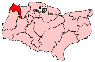
Sevenoaks is a local government district in west Kent, England. Its council is based in the town of Sevenoaks.

The Darent is a Kentish tributary of the River Thames and takes the waters of the River Cray as a tributary in the tidal portion of the Darent near Crayford, as illustrated by the adjacent photograph, snapped at high tide. 'Darenth' is frequently found in the spelling of the river's name in older books and maps, Bartholomew's "Canal's and River of England" being one example. Bartholomew's Gazetteer (1954) demonstrates that Darent means "clear water" and separately explains the other name. Considering the River Darent runs on a bed of chalk and its springs rise through chalk, this is not surprising. The original purity of the water was a major reason for the development of paper and pharmaceuticals in the area.

Greenhithe is a town in the Borough of Dartford in Kent, England, and the civil parish of Swanscombe and Greenhithe. It is located 3.6 miles east of Dartford and 4.5 miles west of Gravesend.

Leigh, historically spelled Lyghe, is a village and a civil parish located in the Sevenoaks district of Kent, England. It is located six miles (10 km) south of Sevenoaks town and three miles (5 km) west of Tonbridge.

West Kingsdown is a village and civil parish in the Sevenoaks district of Kent, England, on the A20 5 miles (8 km) southeast of Swanley, 5.5 miles (9 km) northeast of Sevenoaks and 22.5 miles (36.2 km) from London.
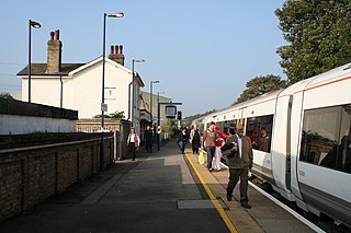
Farningham Road railway station is on the Chatham Main Line in England, serving the villages of Farningham, Sutton-at-Hone, Horton Kirby and South Darenth, Kent. It is 20 miles 41 chains (33.0 km) down the line from London Victoria and is situated between Swanley and Longfield.

Sevenoaks is a constituency represented in the House of Commons of the UK Parliament since 2019 by Laura Trott, a Conservative.
Dartford is a constituency represented in the House of Commons of the UK Parliament since 2010 by Gareth Johnson of the Conservative Party. The constituency is currently the longest-valid 'bellwether' constituency in the country as the party of the winning candidate has gone on to form the government at every UK general election since 1964. Candidates for the largest two parties nationally have polled first and second since 1923 in Dartford.

Horton Kirby is a village in the Sevenoaks District of Kent, England. It is located 3.9 miles east of Swanley & 4.9 miles south of Dartford. Together with the nearby village of South Darenth, it forms the Horton Kirby and South Darenth civil parish.
South Darenth is a village in the civil parish of Horton Kirby and South Darenth in the Sevenoaks District of Kent, England. It is located 4.2 miles east of Swanley & 4.4 miles south of Dartford.

Farningham is a village and civil parish in the Sevenoaks District of Kent, England. It is located 3 miles (5 km) south-east of Swanley. It has a population of 1,314.
Riverhead is a northern village part of the urban area of Sevenoaks in the district of the same name in Kent, England and is also a civil parish. The parish had a population in 2001 of 1821, increasing to 2,634 at the 2011 Census.
Dartford Rural District was a rural district with an area of 34,037 acres (138 km2) in the county of Kent, England. In 1971 it had a population of 64,561 and an electorate of 43,911. At dissolution it was the most populous rural district council in Kent, but had once been larger, having lost territory when Crayford Urban District was created in 1920, and Swanscombe Urban District in 1926.

The waymarked path Darent Valley Path is 19 miles (31 km) long, following the River Darent from the banks of the River Thames at Dartford through the Kent Downs Area of Outstanding Natural Beauty to the Greensand Hills above Sevenoaks. It runs through the villages of Shoreham and Otford.

Axstane was a hundred in the county of Kent, England. The Hundred of Axstane lay south-east of Dartford and Wilmington Hundred. It is called Achestan in Domesday Book, but by the reign of Edward I it was called Axstane.

Go-Coachhire Ltd is a bus operator running a total of 46 bus services across Kent and Sussex. The majority of these services are operated on behalf of Kent County Council from depots in Otford and Swanley.
References
- ↑ "Civil Parish population 2011". Neighbourhood Statisttics. Office for National Statistics. Retrieved 19 September 2016.
