North River is an alternative name for the southernmost portion of the Hudson River in the vicinity of New York City and northeastern New Jersey in the United States.

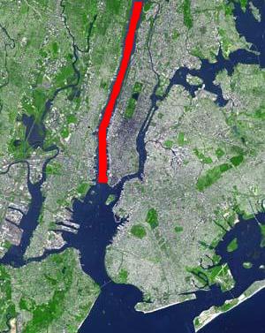
For the purposes of this article, the Jersey City area extends North to Edgewater, South to Bayonne and includes Kearny Junction and Harrison but not Newark. Many routes east of Newark are listed here.

The Pennsylvania Railroad Station was the intermodal passenger terminal for the Pennsylvania Railroad's (PRR) vast holdings on the Hudson River and Upper New York Bay in Jersey City, New Jersey. By the 1920s the station was called Exchange Place. The rail terminal and its ferry slips were the main New York City station for the railroad until the opening in 1910 of New York Pennsylvania Station, made possible by the construction of the North River Tunnels. It was one of the busiest stations in the world for much of the 19th century.

The Central Railroad of New Jersey Terminal, also known as Communipaw Terminal and Jersey City Terminal, was the Central Railroad of New Jersey's waterfront passenger terminal in Jersey City, New Jersey. The terminal was built in 1889, replacing an earlier one that had been in use since 1864. It operated until April 30, 1967.

Pavonia Terminal was the Erie Railroad terminal on the Hudson River situated on the landfilled Harsimus Cove in Jersey City, New Jersey. The station opened in 1861 and closed in 1958 when the Erie Railroad moved its passenger services to nearby Hoboken Terminal. The New York, Susquehanna and Western Railway also ran commuter trains from the terminal and various street cars, ferries and the underground Hudson and Manhattan Railroad serviced the station. The station was abandoned in 1958 and demolished in 1961. The site was eventually redeveloped into the Newport district in the late 20th century.
Bergen Hill refers to the lower Hudson Palisades in New Jersey, where they emerge on Bergen Neck, which in turn is the peninsula between the Hackensack and Hudson Rivers, and their bays. In Hudson County, it reaches a height of 260 feet.

The Hudson River Waterfront Walkway, also known as the Hudson River Walkway, is a promenade along the Hudson Waterfront in New Jersey. The ongoing and incomplete project located on Kill van Kull and the western shore of Upper New York Bay and the Hudson River was implemented as part of a New Jersey state-mandated master plan to connect the municipalities from the Bayonne Bridge to the George Washington Bridge with an urban linear park and provide contiguous unhindered access to the water's edge.

Waldwick is a commuter rail station operated by New Jersey Transit in the borough of Waldwick, Bergen County, New Jersey, United States.

Rutherford is a New Jersey Transit railroad station served by the Bergen County Line located in Rutherford, New Jersey, United States. The station is located near a traffic circle at the junction of Park Avenue, Union Avenue, Erie Avenue and Orient Way known as Station Square, with a grade crossing on Park Avenue.

The Harsimus Stem Embankment, also called Sixth Street Embankment, is a half-mile-long historic railroad embankment, disused and largely overgrown with foliage, in the heart of the historic downtown of Jersey City, New Jersey in the United States. The 27-foot-high (8.2 m) embankment runs along the south side of Sixth Street west from Marin Boulevard to Brunswick Street. It is the border between the Harsimus and Hamilton Park neighborhoods. The overhead tracks of the beam bridge west of Brunswick Street were dismantled but the stone abutments remain.

The Great Atlantic and Pacific Tea Company Warehouse is a historic formerly commercial building at 150 Bay Street in Jersey City, Hudson County, New Jersey, United States. Built as a warehouse for The Great Atlantic & Pacific Tea Company (A&P) in 1900, it is the major surviving remnant of a five-building complex of the nation's first major grocery store chain. It was designated a National Historic Landmark in 1978, and now houses a mix of residences and storage facilities.
Communipaw is a neighborhood in Jersey City in Hudson County, in the U.S. state of New Jersey. It is located west of Liberty State Park and east of Bergen Hill, and the site of one of the earliest European settlements in North America. It gives its name to the historic avenue which runs from its eastern end near Liberty State Park Station through the neighborhoods of Bergen-Lafayette and the West Side that then becomes the Lincoln Highway. Communipaw Junction, or simply The Junction, is an intersection where Communipaw, Summit Avenue, Garfield Avenue, and Grand Street meet, and where the toll house for the Bergen Point Plank Road was situated. Communipaw Cove at Upper New York Bay, is part of the 36-acre (150,000 m2) state nature preserve in the park and one of the few remaining tidal salt marshes in the Hudson River estuary.

The Dr. William Barrow Mansion is located at 83 Wayne Street between Barrow Street and Jersey Avenue in Downtown Jersey City, Hudson County, New Jersey, United States. The mansion was added to the National Register of Historic Places on May 2, 1977, and is located within the Van Vorst Park Historic District, which itself was dedicated on March 5, 1980, and is roughly bounded by Railroad Avenue, and Henderson, Grand, Bright, and Monmouth Streets.
Harsimus is a neighborhood within Downtown Jersey City, Hudson County, in the U.S. state of New Jersey. The neighborhood stretches from the Harsimus Stem Embankment on the north to Christopher Columbus Drive on the south between Coles Street and Grove Street or more broadly, to Marin Boulevard. It borders the neighborhoods of Hamilton Park to the north, Van Vorst Park to the south, the Village to the west, and the Powerhouse Arts District to the east. Newark Avenue has traditionally been its main street. The name is from the Lenape, used by the Hackensack Indians who inhabited the region and could be translated as Crow's Marsh. From many years, the neighborhood was part of the "Horseshoe", a political delineation created by its position between the converging rail lines and political gerrymandering.

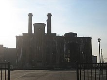
The Beacon is a mixed-use development located on a 14-acre (57,000 m2) site on Bergen Hill, a crest of the Hudson Palisades and one of the highest geographical points in Jersey City, Hudson County, in the U.S. state of New Jersey. The Beacon, which occupies the Jersey City Medical Center's rehabilitated original complex, creates the northeastern corner of the Bergen-Lafayette section and is just east of McGinley Square. The Beacon includes 2,000,000 square feet (190,000 m2) of residential and retail space, approximately 1,200 luxury residences and 80,000 square feet (7,400 m2) of retail space.

Hamilton Park is a neighborhood in Historic Downtown Jersey City, Hudson County, in the U.S. state of New Jersey, centered on a park with the same name. Hamilton Park is located west of Newport, north of Harsimus Cove, north and east of The Village and south of Boyle Plaza. The Victorian age park is located between Eighth Street and Ninth Street and Hamilton Place on the west and McWilliams Place on the East. Like the Van Vorst Park neighborhood to the south, this quiet park is surrounded by nineteenth century brownstones. The park underwent renovations completed in 2010.

Van Vorst Park is a neighborhood in the Historic Downtown of Jersey City, Hudson County, New Jersey, centered on a park sharing the same name. The neighborhood is located west of Paulus Hook and Marin Boulevard, north of Grand Street, east of the Turnpike Extension, and south of The Village and Christopher Columbus Drive. Much of it is included in the Van Vorst Park Historical District.

Hudson County, New Jersey has historic districts which have been designated as such on a municipal, state, or federal level, or combination therof. Some are listed on New Jersey Register of Historic Places and are included on National Register of Historic Places listings in Hudson County, New Jersey. The following is intended to be a list of places which encompasses an area or group of buildings or structures.

Dock Bridge is a pair of vertical lift bridges crossing the Passaic River at Newark, Essex County and Harrison, Hudson County, New Jersey, United States, used exclusively for railroad traffic. It is the seventh crossing from the river's mouth at Newark Bay and is 5.0 miles (8.0 km) upstream from it. Also known as the Amtrak Dock Vertical Lift, it carries Amtrak, NJ Transit, and PATH trains. It is listed on the state and federal registers of historic places.