Hunter, Tennessee

Last updated

Hunter
Stoney Creek
CDP
Hunter-Carter-County-tn1.jpg
TNMap-doton-Hunter.PNG
Location of Hunter, Tennessee
Coordinates: 36°22′36″N82°9′18″W / 36.37667°N 82.15500°W / 36.37667; -82.15500
Country United States
State Tennessee
County Carter
Area
[1]
  Total6.42 sq mi (16.64 km2)
  Land6.40 sq mi (16.57 km2)
  Water0.03 sq mi (0.07 km2)
Elevation
1,568 ft (478 m)
Population
 (2020) [2]
  Total1,803
  Density281.85/sq mi (108.83/km2)
Time zone UTC-5 (Eastern (EST))
  Summer (DST) UTC-4 (EDT)
ZIP code
37643
Area code 423
FIPS code 47-36500 [3]
GNIS feature ID1328513 [4]

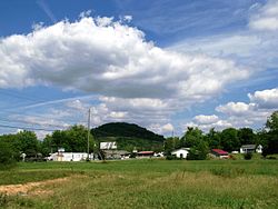
Hunter (also called Stoney Creek) is a census-designated place (CDP) and unincorporated community located northeast of Elizabethton in Carter County, Tennessee, along Tennessee State Route 91 and the Watauga River. Its population was 1,854 as of the 2010 census. [5] It is part of the Johnson City Metropolitan Statistical Area, which is a component of the Johnson City-Kingsport-Bristol, TN-VA Combined Statistical Area commonly known as the "Tri-Cities" region. Hunter is a suburb of Elizabethton.

Contents

Geography

Hunter is located at 36°22′36″N82°9′18″W / 36.37667°N 82.15500°W / 36.37667; -82.15500 (36.376630, -82.155032). [6]

According to the United States Census Bureau, the CDP has a total area of 6.411 square miles (16.60 km2), of which 6.386 square miles (16.54 km2) of it is land and 0.025 square miles (0.065 km2) of it (0.39%) is water.

The Watauga River forms a southern boundary for the Hunter community, while the Holston Mountain forms a northern boundary.

Demographics

Historical population
CensusPop.Note
2020 1,803
U.S. Decennial Census [7]
Whitewater rafters floating downstream by the Hunter Bridge put-in on the Watauga River. WataugaHunterBridgePutIn.jpg
Whitewater rafters floating downstream by the Hunter Bridge put-in on the Watauga River.

As of the census [3] of 2000, there were 1,566 people, 689 households, and 491 families residing in the CDP. The population density was 254.9 inhabitants per square mile (98.4/km2). There were 729 housing units at an average density of 118.6 per square mile (45.8/km2). The racial makeup of the CDP was 99.17% White, 0.13% African American, 0.06% Native American, 0.13% Asian, 0.06% from other races, and 0.45% from two or more races. Hispanic or Latino of any race were 1.15% of the population.

There were 689 households, out of which 27.7% had children under the age of 18 living with them, 57.9% were married couples living together, 10.7% had a female householder with no husband present, and 28.7% were non-families. 25.5% of all households were made up of individuals, and 10.9% had someone living alone who was 65 years of age or older. The average household size was 2.27 and the average family size was 2.71.

In the CDP, the population was spread out, with 19.3% under the age of 18, 8.0% from 18 to 24, 28.7% from 25 to 44, 27.3% from 45 to 64, and 16.7% who were 65 years of age or older. The median age was 41 years. For every 100 females, there were 90.0 males. For every 100 females age 18 and over, there were 88.5 males.

The median income for a household in the CDP was $30,968, and the median income for a family was $37,981. Males had a median income of $25,000 versus $20,668 for females. The per capita income for the CDP was $15,590. About 5.6% of families and 8.7% of the population were below the poverty line, including 9.7% of those under age 18 and 8.5% of those age 65 or over.

Education

Schools in Hunter/Stoney Creek are operated by Carter County Schools:

The Elizabethton campus of Northeast State Community College is located near Hunter.

Connection with U.S. Interstate Highway System

I-26.svg No image.svg US 23.svg Interstate 26 Exit 24 at Johnson City then east on
US 321.svg No image.svg Tennessee 67.svg Tennessee State Route 67 to Elizabethton, then left on
US 321.svg No image.svg Tennessee 67.svg No image.svg US 19E.svg Tennessee State Route 67 /US 19E then right on
No image.svg Secondary Tennessee 91.svg Tennessee State Route 91 Stoney Creek Exit to Hunter.

Related Research Articles

<span class="mw-page-title-main">Washington County, Tennessee</span> County in Tennessee, United States

Washington County is a county located in the U.S. state of Tennessee. As of the 2020 census, the population was 133,001. Its county seat is Jonesborough. The county's largest city and a regional educational, medical and commercial center is Johnson City. Washington County is Tennessee's oldest county, having been established in 1777 when the state was still part of North Carolina. Washington County is part of the Johnson City, TN Metropolitan Statistical Area, which is a component of the Johnson City–Kingsport–Bristol, TN-VA Combined Statistical Area, commonly known as the "Tri-Cities" region.

<span class="mw-page-title-main">Johnson County, Tennessee</span> County in Tennessee, United States

Johnson County is a county located in the U.S. state of Tennessee. As of the 2020 census, the population was 17,948. Its county seat is Mountain City. It is the state's northeasternmost county, sharing borders with Virginia and North Carolina.

<span class="mw-page-title-main">Carter County, Tennessee</span> County in Tennessee, United States

Carter County is a county located in the U.S. state of Tennessee. As of the 2020 census, the population was 56,356. Its county seat is Elizabethton. The county is named in honor of Landon Carter (1760-1800), an early settler active in the "Lost State of Franklin" 1784-1788 secession from the State of North Carolina. Carter County is part of the Johnson City, TN Metropolitan Statistical Area, which is a component of the Johnson City–Kingsport–Bristol, TN-VA Combined Statistical Area, located in northeastern Tennessee.

<span class="mw-page-title-main">West Smithfield, North Carolina</span> Former census-designated place in North Carolina, United States

West Smithfield was an unincorporated community and census-designated place and is now a district of Smithfield, North Carolina in Johnston County, North Carolina, United States. The population was last recorded separately from Smithfield in 2000, when 59 people resided in the CDP.

Parker is a census-designated place (CDP) in Greenville County, South Carolina, United States. The population was 11,431 at the 2010 census, up from 10,760 in 2000. It is part of the Greenville–Mauldin–Easley Metropolitan Statistical Area.

Wildwood Lake is a census-designated place (CDP) in Bradley County, Tennessee, United States. The population was 3,286 at the 2020 Census. It is included in the Cleveland, Tennessee Metropolitan Statistical Area.

Central is an unincorporated community and census-designated place (CDP) in western Carter County, Tennessee, United States. The population was 2,717 at the 2000 census and 2,279 at the 2010 census. It is part of the Johnson City Metropolitan Statistical Area, which is a component of the Johnson City–Kingsport–Bristol, TN-VA Combined Statistical Area – commonly known as the "Tri-Cities" region.

<span class="mw-page-title-main">Elizabethton, Tennessee</span> City in Tennessee, United States

Elizabethton is a city in, and the county seat of Carter County, Tennessee, United States. Elizabethton is the historical site of the first independent American government located west of both the Eastern Continental Divide and the original Thirteen Colonies.

<span class="mw-page-title-main">Roan Mountain, Tennessee</span> CDP in Tennessee, United States

Roan Mountain is a census-designated place (CDP) in Carter County, Tennessee, United States. The population was 1,360 at the 2010 census. It is part of the Johnson City Metropolitan Statistical Area, which is a component of the Johnson City–Kingsport–Bristol, TN-VA Combined Statistical Area – commonly known as the Tri-Cities region.

<span class="mw-page-title-main">Sewanee, Tennessee</span> CDP in Tennessee, United States

Sewanee is a census-designated place (CDP) in Franklin County, Tennessee, United States. The population was 2,535 at the 2020 census. It is part of the Tullahoma, Tennessee Micropolitan Statistical Area.

Fairmount is a census-designated place (CDP) in Hamilton County, Tennessee, United States. The population was 2,193 at the 2020 census, down from 2,825 at the 2010 census. It is part of the Chattanooga, TN–GA Metropolitan Statistical Area.

Colonial Heights is a census-designated place (CDP) in Sullivan County, Tennessee, United States. It is located within the city of Kingsport.

<span class="mw-page-title-main">Unicoi, Tennessee</span> Town in Tennessee, United States

Unicoi is a town in Unicoi County, Tennessee, United States. The population was 3,519 at the 2000 census and 3,632 at the 2010 census. It is part of the Johnson City Metropolitan Statistical Area, which is a component of the Johnson City–Kingsport–Bristol–Erwin–Flag Pond Combined Statistical Area – commonly known as the "Tri-Cities" region.

Midway is an unincorporated community and former census-designated place (CDP) in Washington County, Tennessee. The population was 2,491 at the 2000 census; it was not counted at the 2010 census. It is part of the Johnson City Metropolitan Statistical Area, which is a component of the Johnson City-Kingsport-Bristol, TN-VA Combined Statistical Area – commonly known as the "Tri-Cities" region.

<span class="mw-page-title-main">Keokee, Virginia</span> Census-designated place in Virginia, United States

Keokee is an unincorporated community and census-designated place (CDP) in Lee County, Virginia, United States. The population was 416 at the 2010 census.

<span class="mw-page-title-main">North Marysville, Washington</span> CDP in Washington, United States

North Marysville is a census-designated place (CDP) in Snohomish County, Washington, United States. The majority of the community and its 20,000 residents were annexed into the city of Marysville in 2009. The population was 108 at the 2010 census.

<span class="mw-page-title-main">Watauga, Tennessee</span> City in Tennessee, United States

Watauga is a city in Carter and Washington counties in the U.S. state of Tennessee. The population was 403 at the 2000 census, 458 at the 2010 census, 361 in the 2020 census. It is part of the Johnson City Metropolitan Statistical Area, which is a component of the Johnson City-Kingsport-Bristol, TN-VA Combined Statistical Area – commonly known as the "Tri-Cities" region.

Spurgeon is a census-designated place (CDP) in Sullivan and Washington counties in the U.S. state of Tennessee. The population was 3,957 at the 2010 census.

<span class="mw-page-title-main">Pine Plains (CDP), New York</span> Census-designated place in New York, United States

Pine Plains is a hamlet and census-designated place (CDP) in Dutchess County, New York, United States. The population was 1,142 at the 2020 census. It is part of the Poughkeepsie–Newburgh–Middletown, NY Metropolitan Statistical Area as well as the larger New York–Newark–Bridgeport, NY-NJ-CT-PA Combined Statistical Area.

Woodland is a census-designated place (CDP) in the town of Baileyville, Washington County, Maine, United States. The population was 952 at the 2010 census.

References

  1. "ArcGIS REST Services Directory". United States Census Bureau. Retrieved October 15, 2022.
  2. "Census Population API". United States Census Bureau. Retrieved October 15, 2022.
  3. 1 2 "U.S. Census website". United States Census Bureau . Retrieved January 31, 2008.
  4. "US Board on Geographic Names". United States Geological Survey. October 25, 2007. Retrieved January 31, 2008.
  5. "U.S. Census website". United States Census Bureau . Retrieved May 14, 2011.
  6. "US Gazetteer files: 2010, 2000, and 1990". United States Census Bureau. February 12, 2011. Retrieved April 23, 2011.
  7. "Census of Population and Housing". Census.gov. Retrieved June 4, 2016.