Hurley, Warwickshire

Last updated

Hurley
The Holly Bush, Hurley - geograph.org.uk - 108603.jpg
The Holly Bush pub
Warwickshire UK location map.svg
Red pog.svg
Hurley
Location within Warwickshire
OS grid reference SP 2430 9598
Civil parish
  • Kingsbury
District
Shire county
Region
Country England
Sovereign state United Kingdom
Post town Atherstone
Postcode district CV9
Dialling code 01827
Police Warwickshire
Fire Warwickshire
Ambulance West Midlands
UK Parliament
Website Kingsbury Parish Council
List of places
UK
England
Warwickshire
52°33′40″N1°38′35″W / 52.561°N 1.643°W / 52.561; -1.643

Hurley is a village in the Kingsbury civil parish of North Warwickshire, England. Other nearby places include Wood End, Hurley Common, Coleshill, Water Orton, Curdworth, Atherstone and Tamworth. According to the 2001 Census the population of the Hurley and Wood End ward was 3,642. [1] Over 99.5% of people (3,550) described themselves as White British with only 92 people from other ethnic groups. The most common distance travelled to work is 5–10 kilometres (3.1–6.2 mi), which is essentially to Tamworth, with the most common form of employment being manufacturing. The village has an almost exact 50:50 split of males and females, with a ratio of 1,822 to 1,820 respectively.

Contents

History

Hurley became a village in 1861 when its Church of the Resurrection was consecrated. There were a number of mines in the Hurley area, including Dexter Colliery which opened in 1926. Some of the social housing in the village was built to accommodate workers at the mines. During the early half of the 20th century the majority of people who lived in the village worked in nearby collieries, including Dexter Colliery and Kingsbury Colliery. Both closed in the late 1960s.

Religion

Church of the Resurrection Church of the Resurrection, Hurley - geograph.org.uk - 110628.jpg
Church of the Resurrection

According to the 2001 Census the ward of Hurley and Wood End is 80% Christian, 19% Non-Religious and 1% Other. [2] The Church of England Church of the Resurrection is a wooden mission church, part of the Kingsbury and Baxterley Group of Churches. [3] Hurley is in the Roman Catholic Parish of St John the Baptist, of which the main collegiate church is St John's Presbytery in Tamworth.

Economy

Hurley is served by a small village store and Post Office on Brick Kiln Lane. There is an Indian takeaway on Knowle Hill. The village also has two public houses called the Holly Bush Inn and The Anchor Inn on Hurley Common. The headquarters of the construction and maintenance firm Promanex Group are just outside Hurley. [4] Most residents commute to work in Tamworth, Atherstone, Nuneaton, Birmingham and Coventry, [5] with manufacturing being the most common type of employment, followed by wholesale and retail.

Governance

The village was part of the Tamworth Rural District from its creation in 1894, until 1965 when it became part of the Atherstone Rural District. In 1974 under the Local Government Act 1972 Hurley became part of the newly formed district of North Warwickshire. Inside North Warwickshire it is part of the Hurley and Wood End Ward, and because of the mining connection the village often elects Labour councillors. Hurley is part of the North Warwickshire parliamentary constituency and the current MP is Conservative Craig Tracey.

Crime

In 2009 there was an average of 3.6 crimes per 1,000 people for the ward of Hurley and Wood End, and during the same period there were 5 crimes per head for the borough of North Warwickshire. In 2010 the figure was down to 3 crimes per head. The most common type of crime is anti-social behaviour. [6]

Education

There is a small primary school, Hurley Primary School, for children up to the age of 11. [7] [8] The village does not have its own secondary school, so most students attend Kingsbury School in Kingsbury. In terms of further education the area is served by North Warwickshire and Hinckley College at Nuneaton. There is also Tamworth and Lichfield College.

Public services

Water and sewage services are provided by Severn Trent Water. The nearest police and fire stations are in Atherstone. [9] Unlike Kingsbury, Hurley uses a Coventry (CV) postcode rather than a Birmingham (B) postcode. The postal town is Atherstone. The village lies in the North Warwickshire NHS trust area. The village has a small GP's office on Knowle Hill which is part of a larger practice in Kingsbury. The George Eliot Hospital at Nuneaton is the area's local hospital. It has an Accident and Emergency Department. Out of hours GP services are also based at George Eliot. There is also Good Hope Hospital in Sutton Coldfield. Local facilities include a village hall, and a small playing field and play area on Brick Kiln Lane. The nearest leisure facilities are based in Kingsbury at the village's Kingsbury school. A little further afield is the Snowdome in Tamworth.

Transport

Hurley lies close to the M42 at junction 10. The village has seven bus stops and is served by routes 766, 767, 115, 118 and 119, linking it to Atherstone, Kingsbury and Tamworth. There is a market day bus to Atherstone on Tuesdays. The nearest railway station is Wilnecote. The nearest airport is Birmingham.

Media

The local newspaper covering the area is the Tamworth Herald , which has a separate edition for North Warwickshire. Local radio includes BBC Coventry & Warwickshire, Free Coventry & Warwickshire and Touch FM. The village is covered by the Central ITV and BBC West Midlands TV regions broadcast from the nearby Sutton Coldfield transmitting station.

See also

Related Research Articles

<span class="mw-page-title-main">Atherstone</span> Market town and civil parish in Warwickshire, England

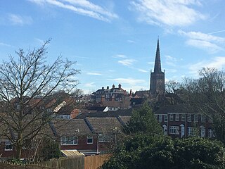
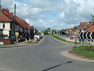
Atherstone is a market town and civil parish in the North Warwickshire district of Warwickshire, England. Located in the far north of the county, Atherstone is on the A5 national route, and is adjacent to the border with Leicestershire which is here formed by the River Anker. It is situated between the towns of Tamworth and Nuneaton. Atherstone is the administrative centre of the North Warwickshire district, with the offices of North Warwickshire Borough Council located in the town.

<span class="mw-page-title-main">Warwickshire</span> County of England

Warwickshire is a ceremonial county in the West Midlands of England. It is bordered by Staffordshire and Leicestershire to the north, Northamptonshire to the east, Oxfordshire and Gloucestershire to the south, and Worcestershire and the West Midlands county to the west. The largest settlement is Nuneaton and the county town is Warwick.

<span class="mw-page-title-main">North Warwickshire</span> Borough & Non-metropolitan district in England

North Warwickshire is a local government district with borough status in the ceremonial county of Warwickshire, West Midlands, England. The borough includes the two towns of Atherstone and Coleshill, and the large villages of Polesworth, Kingsbury, Hartshill and Water Orton.

<span class="mw-page-title-main">Coleshill, Warwickshire</span> Market town in Warwickshire, England

Coleshill is a market town and civil parish in the North Warwickshire district of Warwickshire, England, taking its name from the River Cole, on which it stands. It had a population of 6,897 in the 2021 Census, and is situated 10 miles (16 km) east-northeast of Birmingham, 9 miles (14 km) southeast of Sutton Coldfield, 11 miles (18 km) south of Tamworth, 13 miles (21 km) northwest of Coventry by road and 13 miles (21km) west of Nuneaton.

<span class="mw-page-title-main">Kingsbury, Warwickshire</span> Human settlement in England

Kingsbury is a large village and civil parish in the North Warwickshire district of the county of Warwickshire, in the West Midlands region of England. The civil parish population at the 2011 census was 7,652.

<span class="mw-page-title-main">North Warwickshire (UK Parliament constituency)</span>

North Warwickshire is a constituency represented in the House of Commons of the UK Parliament since 2015 by Craig Tracey, a Conservative.

<span class="mw-page-title-main">Baddesley Ensor</span> Village and civil parish in Warwickshire, England

Baddesley Ensor is a village and civil parish in the district of North Warwickshire in Warwickshire, England, about three miles west of Atherstone. It runs into the village of Grendon, which forms a parish itself.

Ansley is a civil parish in Warwickshire consisting of Ansley, Ansley Common, Church End, Birchley Heath and, previously, Ansley Hall Colliery.

<span class="mw-page-title-main">Baxterley</span> Human settlement in England

Baxterley is a small village and civil parish in the North Warwickshire district of Warwickshire in England. According to the 2001 Census, it had a population of 335, reducing to 328 at the 2011 Census. The village is about two miles west of Atherstone and is home to Jaguar Land Rover's national distribution centre.

<span class="mw-page-title-main">Wood End, Kingsbury, Warwickshire</span> Human settlement in England

Wood End is a former Pit village in North Warwickshire, England. It lies to the south east of Tamworth and close to the border with Staffordshire. It grew around the former Kingsbury Colliery but now it serves as a commuter village to Tamworth. It has a church, a primary school, a co-operative store, a working men's club and a village hall. The population of Wood End is 2,205, but from the 2011 Census has been included in Kingsbury.

<span class="mw-page-title-main">Dordon</span> Human settlement in England

Dordon is a village and civil parish in the North Warwickshire district of the county of Warwickshire in England and close to the border with Staffordshire. The village is located on the A5 national route and is contiguous with the larger village of Polesworth. Other nearby places include Tamworth, Atherstone, Grendon, Wood End Village, Baddesley Ensor and Nuneaton. In 2001 the population for the parish of Dordon was 3,225, reducing slightly to 3,215 at the 2011 census.

<span class="mw-page-title-main">Merevale</span> Human settlement in England

Merevale is a small village and civil parish in the North Warwickshire district of the county of Warwickshire in England. Located about one and a half miles west of Atherstone, it is the site of a medieval Cistercian Abbey and Merevale Hall.

<span class="mw-page-title-main">Old Arley</span> Village in Warwickshire, England

Old Arley is a village in the civil parish of Arley, in the north of Warwickshire, England, 5.5 miles (8.9 km) west of Nuneaton and 10 miles (16 km) north west of the city of Coventry.

Piccadilly is a small village in the North Warwickshire district of the county of Warwickshire in England. It is located near to the larger village of Kingsbury, and is four miles south of Tamworth.

<span class="mw-page-title-main">Shuttington</span> Human settlement in England

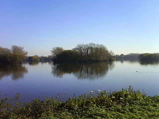
Shuttington is a village and civil parish in North Warwickshire, England, situated north-east of Tamworth, Staffordshire. In the 2001 census, the parish, which also includes Alvecote, had a population of 563, decreasing to 536 at the 2011 census. The River Anker flows through the parish, with Shuttington north-east of the river, and Alvecote south of it. The West Coast Main Line passes through Alvecote, with the Coventry Canal parallel to it and a marina south of the canal. Most of the parish is rural, including the village of Shuttington, although there was colliery alongside the railway at Alvecote.

<span class="mw-page-title-main">St Michael & All Angels Church, Wood End</span> Church

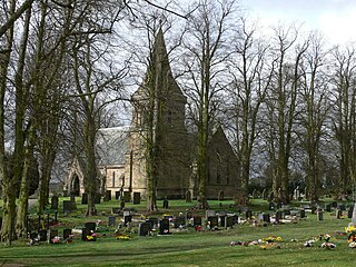
St Michael & All Angels Church is a Church of England church in the village of Wood End, Warwickshire, England. Built in 1906, this small wooden church is part of the parish of Baxterley with Hurley and Wood End

<span class="mw-page-title-main">Hurley Common</span> Human settlement in England

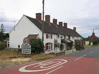
Hurley Common is a village in North Warwickshire, England, between Wood End and Hurley, it consists of several houses and 2 Farms, Hurley common does not have its own Parish Church so it is technically a hamlet. Population details for the 2011 Census can be found under Kingsbury.

Hurley and Wood End is a ward within North Warwickshire, it is named after the villages of Hurley and Wood End, the ward also contains the villages of Piccadilly, Hurley Common and Foul End. The ward is covered by Kingsbury Civil Parish.

<span class="mw-page-title-main">Foul End</span> Human settlement in England

Foul End is a small hamlet in the civil parish of Kingsbury, in the North Warwickshire district, in the county of Warwickshire, England. Other nearby places include Hurley, Wood End, Hurley Common, Coleshill, Water Orton, Curdworth, Atherstone and Tamworth.

<span class="mw-page-title-main">Grendon, Atherstone</span> Human settlement in England

Grendon is a civil parish which includes both Old Grendon and New Grendon in North Warwickshire, England. Old Grendon is a village situated three miles (5 km) west of Atherstone and five miles (8 km) east of Tamworth centred on the A5. It lies on the north-western tip of Warwickshire, divided from Leicestershire by a small stream and by the River Anker. Also, Grendon has since enlarged and has a population of 1000.

References

  1. 2001 census statistics
  2. Neighbourhood Statistics
  3. Kingsbury and Baxterley Group of Parish Churches Website
  4. Promanex Group Archived 2 April 2015 at the Wayback Machine
  5. Distance Travelled to Work
  6. Crime Statistics For Hurley And Wood End Archived 21 July 2011 at the Wayback Machine
  7. Ofsted
  8. Schools.com
  9. Warwickshire Police Stations Archived 1 January 2011 at the Wayback Machine