In its path,Charlie,dubbed the Killer Hurricane by international media,caused more than 250deaths,ranking among the deadliest Atlantic hurricanes of the 20th century. The hurricane produced Jamaica's deadliest natural disaster of the 20th century,causing more than 152deaths and $50,000,000in damages. The hurricane was described as Tampico's worst tropical cyclone since 1936,and it caused more than 100fatalities in the surrounding areas. Many bodies were not recovered after flooding. The hurricane produced peak gusts of 160mph (260km/h) at the airport,and its strongest sustained winds were unmeasured in mainland Mexico,giving rise to suggestions at the time that it may have been a Category4 hurricane at landfall,though available data indicate that it was more likely a marginal Category3 hurricane upon striking land in Tamaulipas.
Meteorological history
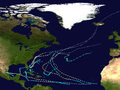
Map plotting the storm's track and intensity,according to the Saffir–Simpson scale
Surface weather map on August 17, showing Hurricane Charlie approaching Jamaica
On August16, Tropical Storm Charlie, continuing to deepen, attained maximum sustained winds of 75mph (120km/h) by 06:00UTC, becoming equivalent to a Category1 hurricane on the current Saffir–Simpson scale. Maintaining its north-of-due-west heading, the hurricane moved rapidly west-northwestward over the eastern Caribbean, while located about 180miles (290km) south-southwest of San Juan. Just before 19:00UTC on August17, United States Air Force (USAF) Hurricane Hunters intercepted the tiny, 5-nautical-mile-wide (5.8mi; 9.3km)eye of Charlie and measured an atmospheric pressure of 971mb (28.7inHg), which suggested maximum sustained winds of 110mph (175km/h) at the time, making Charlie equivalent to a high-end Category2 hurricane.[2] The cyclone rapidly intensified into a major hurricane, which is Category3 or higher on the Saffir–Simpson scale, as it neared Jamaica, and made landfall at 03:00UTC on August18, a short distance south of Kingston, with winds of 125mph (205km/h), becoming the strongest hurricane to make landfall on the island prior to Hurricane Gilbert in 1988.[9] The city of Kingston reported peak winds of 110mph (180km/h) as the center passed 8mi (13km) to the south, and the minimum central pressure in the eye was tentatively estimated to have been near 958mb (28.3inHg).[2][7] The small hurricane weakened rapidly once inland, and some time after 06:00UTC left Jamaica with winds of 85mph (140km/h), but quickly re-intensified over water. It passed south of the Cayman Islands, generating gusts of 92mph (148km/h) on Grand Cayman.[7] By 18:00UTC on August19, the cyclone regained major-hurricane intensity, and sixhours later peaked with winds of 130mph (215km/h), equivalent to a low-end Category4 hurricane. At 03:00UTC on August20, Charlie made landfall on the Yucatán Peninsula near Akumal, Quintana Roo, at its peak intensity.[9]Cozumel, north of the eye, registered hurricane-force winds and a barometric pressure of 965mb (28.5inHg).[2] Charlie subsequently weakened as it crossed the Yucatán Peninsula.[1]
Upon reaching the Gulf of Mexico, Charlie had weakened to a minimal hurricane. On August21, it maintained intensity while crossing the Gulf of Mexico until 18hours before landfall. Beginning early on August22, Charlie once again underwent rapid intensification, strengthening to its second peak of 115mph (185km/h) just off the mainland Mexican coast; operationally, the Hurricane Hunters indicated peak winds of 130mph (215km/h) at the time, which would have made Charlie a Category4 hurricane, but these were subsequently deemed an overestimate by reanalysis.[7] At 19:00UTC, Charlie made landfall near Ciudad Madero, just north of Tampico, at the same intensity, equivalent to a low-end Category3 hurricane.[2] The city of Tampico entered the southern portion of the storm's eye, registering a minimum barometric pressure of 28.81inHg (976mb) and peak winds of 110mph (180km/h). The strongest winds were believed to have been north of the eye, and were unrecorded, while the storm's lowest pressure was estimated to have been near 968mb (28.6inHg) at landfall, for the winds at Tampico only lulled during the passage of the eye and did not indicate a complete calm.[7][2] After landfall, the storm quickly weakened over land, and it dissipated late on August23 in the Mexican state of Tamaulipas.[1]
Preparations
On August 15, the Weather Bureau office in San Juan issued hurricane warnings for the eastern Caribbean from Martinique to Antigua, while storm warnings were released for the rest of the Leeward Islands.[3] Later, hurricane warnings were also issued for the northern Leeward Islands, and northeast storm warnings were released for Puerto Rico and the Virgin Islands.[10] In advance of the hurricane, flights' scheduled departures for the Barbados region were delayed.[11] On August 17, the Weather Bureau noted that the hurricane would affect Jamaica, though it was not expected to strengthen significantly; the agency also reported that the probabilities were equal for the cyclone to pass north or south of the island.[12] Later, the cyclone was forecast to pass "over or just south" of the island; Jamaica was urged to prepare for the cyclone, and the hurricane was expected to strengthen as the forward motion decreased.[13] On August 20, the cyclone was expected to affect the northern Yucatán Peninsula between Mérida and Campeche, and "extreme caution" was advised for the area.[14]
The hurricane was also expected to re-strengthen prior to its second landfall in Mexico, though the Weather Bureau also noted that there was a chance for the storm to affect Texas.[14] Although the possibility never materialized, the agency expected rain bands and rough seas to affect southern Texas, and small watercraft were urged to remain in ports until the hurricane moved inland.[15] On August 21, the cyclone was expected to move ashore between Nautla and Tuxpan,[15] though it eventually made landfall further north near Tampico.[1] Local officials expressed concerns about residents in huts and other vulnerable structures.[15] In the Harlingen Valley region of southern Texas, precautionary measures were taken and Red Cross divisions organized a meeting at the local city hall. City departments and facilities were ready for disposal if the cyclone moved closer to the area.[16] The cyclone's rains were also expected to impact unpicked cotton plants in the region.[17] In advance of the storm, a Coast Guard plane dropped messages from the air to several vessels, advising them to seek shelter.[16] In Tampico, oil industries erected barriers to protect fields, and authorities planned to evacuate residents from the surrounding low-lying areas. Thousands of residents stayed in refugee centers on elevated ground.[17]
Impact
The cyclone was compact when it moved through the Lesser Antilles, and the strongest winds on land in the eastern Caribbean islands did not reach gale force.[7]
In Jamaica, the hurricane produced heavy rainfall that peaked at 17 inches (430mm) in Kingston,[18][7] which caused numerous landslides across eastern sections of the island.[19] Peak gusts were estimated near 125mph (201km/h) across the island.[20] Kingston reported its greatest natural disaster since the 1907earthquake, with 54dead citywide.[21] A hangar and installations were destroyed at Palisadoes Airport,[18] and the facility received "extensive damage."[20] Consequently, Chicago and Southern Airlines headquarters in Memphis, Tennessee, notified the press that its Constellation flights from Chicago to Caracas via Kingston were forced to divert their operations from Kingston.[20] Several ships were sunk or overturned during the storm.[18][20] Communications and power services were disrupted, suspending information from the island's interior.[18] Four-fifths of Morant Bay were destroyed, and Port Royal was reportedly flattened. May Pen and Spanish Town incurred significant damage as well.[21] The hurricane also cut communications from the island to radio stations in the United States.[20] 70–80% of the island's banana crops were destroyed, in addition to 30% of other crops.[15] 70 convicted felons also escaped from a jail when winds blew down walls.[22] Flooding was expected in the island's mountainous interior because of heavy precipitation.[18] Heavy rains caused rock slides, damaging roads, railroads, and other sources of tourism.[15] In Kingston, electricity was initially restored to essential services, including newspaper and refrigerating plants, hospitals, and pumping stations.[15] On Jamaica Charlie caused around $50million (1951USD, $380million 2005USD) in crop and property damage, killed 152people, injured 2,000, and left 25,000homeless.[7]
On the Yucatán Peninsula, Charlie destroyed up to 70% of the crops, though no loss of life was reported in the area.[7] Unofficially, one person was reportedly killed on the peninsula.[15] Mérida reported winds of 70mph (110km/h).[15] The winds toppled several thatched homes on Cozumel.[16] A wind gust of 160mph (260km/h) was measured at the airport near Tampico,[23] though peak gusts in the city did not exceed 110mph (180km/h).[7] The storm was reported to be the worst in Tampico since 1936. The winds uprooted trees and destroyed telephone poles, and damages to corn crops were believed to exceed $500,000.[23] At least 300 residences were "damaged or destroyed."[23] Outside the city, Charlie's heavy rain led to bursting dams and flooded rivers, where upward of 100people died. In the city, four people died, and property losses were estimated near $1,160,000.[7] Across Mexico, the hurricane killed 257people.[24]
The hurricane's outer fringes produced swells along the Texas coast, and swimmers were advised to be cautious because of hazardous conditions.[22] The area was also experiencing rough swells and strong winds from an unrelated weather system, which produced peak gusts of 60mph (97km/h).[22] The conditions snarled marine operations in the area, and three fishermen were missing during the squall.[22] On August 23, Brownsville experienced gusts of 50mph (80km/h) when the hurricane struck the coast further south.[23]
Aftermath
In the wake of this storm, Jamaica formed a new governmental entity known as the Hurricane Housing Organization. In 1956, this organization merged with the Central Housing Authority to become the Department of Housing.[25] With an estimated 259or more fatalities in Mexico and Jamaica, Charlie ranks among the deadliest Atlantic hurricanes on record in the 20th century.[26]Lord Beginner wrote a calypso song about the hurricane's landfall in Jamaica entitled "Jamaica Hurricane". The next hurricane to make landfall on Jamaica, Hurricane Gilbert, occurred 37years later.[27]
↑Note, however, that reconnaissance-derived estimates of wind speed are considered unreliable prior to the mid-1970s, if not more than a decade later.[5]
↑ Written at Miami. "Hurricane in the Caribbean: Planes Held Up". The Daily Gleaner. Vol.117, no.189. Kingston, Jamaica (published August 15, 1951). August 16, 1951. p.1. Retrieved 13 April 2023– via Newspaper Archive.
12 Written at Tampico, Mexico. "Tampico Girds for Hurricane". Fairfield Daily Ledger. Vol.152, no.198. Fairfield, Iowa. United Press International. August 21, 1951. p.6. Retrieved 12 April 2023– via Newspaper Archive.
↑ Written at Miami, Florida. "It's Time (June) to Watch for Anna..."The Sunday Gleaner. Vol.30, no.21 (Sundayed.). Kingston, Jamaica (published June 1, 1969). Associated Press. May 31, 1969. p.1. Retrieved 12 April 2023– via Newspaper Archive.
"The Hurricane and Its Effects"(PDF). Hurricane Gilbert – Jamaica(PDF) (Technical report). Disaster Reports. Pan American Health Organization Emergency Preparedness and Disaster Relief Coordination Program. February 20, 1999. pp.5–8. 5, Hurricane Gilbert in Jamaica. Archived from the original(PDF) on 22 February 2012 – via Centro Regional de Información sobre Desastres América Latina y El Caribe.
This page is based on this Wikipedia article Text is available under the CC BY-SA 4.0 license; additional terms may apply. Images, videos and audio are available under their respective licenses.