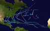
The 1995 Atlantic hurricane season was an extremely active Atlantic hurricane season and is considered to be the start of an ongoing era of high-activity tropical cyclone formation. The season produced twenty-one tropical cyclones, nineteen named storms, as well as eleven hurricanes and five major hurricanes. The season officially began on June 1 and ended on November 30, dates which conventionally delimit the period of each year when most tropical cyclones develop in the Atlantic basin. The first tropical cyclone, Hurricane Allison, developed on June 2, while the season's final storm, Hurricane Tanya, transitioned into an extratropical cyclone on November 1. The very active Atlantic hurricane activity in 1995 was caused by La Niña conditions, which also influenced a very inactive Pacific hurricane season.
Hurricane Danielle was a long-lived Cape Verde hurricane in late August and early September 1998. The fourth named storm and second hurricane of the annual hurricane season, Danielle originated from a tropical wave that emerged off the western coast of Africa on August 21. Tracking generally west-northwestward, the disturbance was initially disorganized; under favorable atmospheric conditions, shower and thunderstorm activity began to consolidate around a low-pressure center. Following a series of satellite intensity estimates, the system was upgraded to Tropical Depression Four during the pre-dawn hours of August 24, and further to Tropical Storm Danielle that afternoon. Moving around the southern periphery of the Azores High located in the northeastern Atlantic, quick intensification to hurricane status occurred early on August 25. By 0600 UTC the following day, Danielle reached an initial peak intensity of 105 mph (169 km/h), a Category 2 hurricane. Increased wind shear from a nearby trough encroached on further development later that day, and subsequently led to slight weakening. By 1200 UTC on August 27, despite continued unfavorable conditions, Danielle reached a second peak intensity equal to the first. Weakening once ensued late on August 27 in addition to the days following, and Danielle was a low-end Category 1 hurricane by August 31 as its forward speed slowed.

The 1964 Atlantic hurricane season featured the highest number of U.S.-landfalling hurricanes since 1933. The season officially began on June 15, and lasted until November 30. These dates conventionally delimit the period of each year when most tropical cyclones form in the Atlantic basin. The season was above average, with thirteen named storms, seven hurricanes, and five major hurricanes. The first system, an unnamed tropical storm, developed on June 2, almost two weeks before the official start of the season. Striking Florida on June 6, the storm brought localized flooding to portions of Cuba and the Southeastern United States, leaving about $1 million in damage. The next storm, also unnamed, developed near the end of July; it did not impact land.

The 1968 Atlantic hurricane season was one of five Atlantic hurricane seasons during the satellite era not to feature a major hurricane, the others being 1972, 1986, 1994, and 2013. The season officially began on June 1 and lasted until November 30, dates which conventionally delimit the period of each year when most tropical cyclones form in the Atlantic basin. It was a below average season in terms of tropical storms, with a total of eight nameable storms. The first system, Hurricane Abby, developed in the northwestern Caribbean on June 1. Abby moved northward and struck Cuba, bringing heavy rainfall and flooding to western portions of the island. Making landfall in Florida on June 4, Abby caused flooding and spawned four tornadoes, but left behind little damage. Overall, the hurricane resulted in six deaths and about $450,000 (1968 USD) in damage. In late June, Tropical Storm Candy brought minor flooding and spawned several tornadoes across portions of the Southern United States. Overall damage from the cyclone reached approximately $2.7 million.

The 1975 Atlantic hurricane season featured the first tropical storm to be upgraded to a hurricane based solely on satellite imagery – Hurricane Doris. The season officially began on June 1 and lasted until November 30. These dates conventionally delimit the period of each year when most tropical cyclones form in the Atlantic basin. The season was near average, with nine tropical storms forming, of which six became hurricanes. Three of those six became major hurricanes, which are Category 3 or higher on the Saffir–Simpson scale. The first system, Tropical Depression One, developed on June 24. Tropical Storm Amy in July caused minor beach erosion and coastal flooding from North Carolina to New Jersey, and killed one person when a ship capsized offshore North Carolina. Hurricane Blanche brought strong winds to portions of Atlantic Canada, leaving about $6.2 million (1975 USD) in damage. Hurricane Caroline brought high tides and flooding to northeastern Mexico and Texas, with two drownings in the latter.

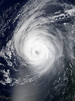
Hurricane Alex was one of the northernmost major hurricanes on record, and whose formation marked the fifth-latest start to a season since 1954. The first named storm, the first hurricane, and the first major hurricane of the 2004 Atlantic hurricane season, Alex developed from the interaction between an upper-level low and a weak surface trough on July 31 to the east of Jacksonville, Florida. It moved northeastward, and strengthened to attain winds of 100 mph (160 km/h) before passing within 10 miles (16 km) of the Outer Banks coast. Alex strengthened further and reached a peak of 120 mph (190 km/h) winds while off the coast of New England, one of only six hurricanes to reach Category 3 status north of 38° N. Alex caused a scare of a hurricane-force direct hit in the Outer Banks of North Carolina, which had been devastated by Hurricane Isabel less than a year earlier.

The 1948 Atlantic hurricane season featured the first tropical cyclone before the month of June since 1940. The season officially began on June 15, 1948, and lasted until November 15, 1948. These dates conventionally delimit the period of each year when most tropical cyclones form in the Atlantic basin. There were 10 tropical cyclones; six storms attained hurricane status, and four storms intensified into major hurricanes, which are Category 3 or higher on the modern-day Saffir–Simpson hurricane wind scale. Operationally, it was believed that a weak tropical disturbance formed over the southeast Bahamas in May and moved northwest into the Georgia coast near Savannah. This system was later excluded from HURDAT. The seventh tropical cyclone was not operationally considered a tropical cyclone, but was later added to HURDAT.
Hurricane Irene was a long-lived Cape Verde hurricane during the 2005 Atlantic hurricane season. The storm formed near Cape Verde on August 4 and crossed the Atlantic, turning northward around Bermuda before being absorbed by an extratropical cyclone while situated southeast of Newfoundland. Irene proved to be a difficult storm to forecast due to oscillations in strength. After almost dissipating on August 10, Irene peaked as a Category 2 hurricane on August 16. Irene persisted for 14 days as a tropical system, the longest duration of any storm of the 2005 season. It was the ninth named storm and fourth hurricane of the record-breaking season.

Tropical Storm Gilda in 1973 was the first documented tropical cyclone on record to transition into a subtropical cyclone. It formed on October 16 in the western Caribbean Sea from a tropical wave, and strengthened to reach peak winds of 70 mph (110 km/h) before striking Cuba. It later moved slowly through the Bahamas before weakening to tropical depression status. On October 24, with the assistance of a cold front off the coast of the eastern United States, Gilda transformed into a subtropical storm, becoming very large and strong. The storm later accelerated northeastward and became extratropical, ultimately dissipating near Greenland.

Hurricane Gladys was a tropical cyclone that caused minor impact along the East Coast of the United States, Bermuda, and Atlantic Canada. The ninth named storm and fifth hurricane of the 1964 Atlantic hurricane season, Gladys developed from a tropical wave located east of the Lesser Antilles on September 13. Shortly thereafter, it strengthened into a tropical storm. On September 14, Gladys abruptly intensified into a Category 2 hurricane on the Saffir–Simpson hurricane wind scale. However, early on the following day, Gladys weakened slightly to a Category 1 hurricane. Between late on September 16 and late on September 17, the storm rapidly strengthened, peaking as a 145 mph (233 km/h) Category 4 hurricane on the latter. Gladys began weakening on the following day and curved northward on September 19.

The 1924 Atlantic hurricane season featured the earliest known Category 5 hurricane – a tropical cyclone with maximum sustained winds exceeding 155 mph (249 km/h). The first system, Tropical Storm One, was first detected in the northwestern Caribbean Sea on June 18. The final system, an unnumbered tropical depression, dissipated on November 24. These dates fall within the period with the most tropical cyclone activity in the Atlantic. Of the 13 tropical cyclones of the season, six existed simultaneously. The season was average with 11 tropical storms, five of which strengthened into hurricanes. Further, two of those five intensified into major hurricanes, which are Category 3 or higher on the Saffir–Simpson hurricane wind scale.

Hurricane Ella was the strongest hurricane on record in Canadian waters. It formed on August 30, 1978 to the south of Bermuda, and quickly intensified as it tracked west-northwestward. By September 1, Ella reached winds of 125 mph (201 km/h), and it was expected to pass close to the Outer Banks of North Carolina during the busy Labor Day Weekend. The hurricane became stationary for about 24 hours, and later turned to the northeast away from the coast. On September 4, Ella reached Category 4 status on the Saffir-Simpson Hurricane Scale off the coast of Nova Scotia. It subsequently weakened, passing southeast of Newfoundland before being absorbed by a large extratropical cyclone.

The 2012 Atlantic hurricane season was the final year in a consecutive string of three very active seasons since 2010, with 19 tropical storms; although many of the storms were weak and short-lived. The 2012 season was also a costly season in terms of property damage, and remains the fifth-costliest season, behind 2021, 2022, 2005 and 2017. The season officially began on June 1 and ended on November 30, dates that conventionally delimit the period during each year in which most tropical cyclones form in the Atlantic Ocean. However, Alberto, the first named system of the year, developed on May 19 – the earliest date of formation since Subtropical Storm Andrea in 2007. A second tropical cyclone, Beryl, developed later that month. This was the first occurrence of two pre-season named storms in the Atlantic basin since 1951. It moved ashore in North Florida on May 29 with winds of 65 mph (105 km/h), making it the strongest pre-season storm to make landfall in the Atlantic basin. This season marked the first time since 2009 where no tropical cyclones formed in July. Another record was set by Hurricane Nadine later in the season; the system became the fourth-longest-lived tropical cyclone ever recorded in the Atlantic, with a total duration of 22.25 days. The final storm to form, Tony, dissipated on October 25 – however, Hurricane Sandy, which formed before Tony, became extratropical on October 29.

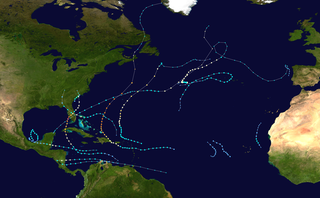
The 2020 Atlantic hurricane season featured a total of 31 tropical or subtropical cyclones, making it the most active Atlantic hurricane season on record. All but one cyclone became a named storm. Of the 30 named storms, 14 developed into hurricanes, and a record-tying seven further intensified into major hurricanes. It was the second and final season to use the Greek letter storm naming system, the first being 2005, the previous record. Of the 30 named storms, 11 of them made landfall in the contiguous United States, breaking the record of nine set in 1916. During the season, 27 tropical storms established a new record for earliest formation date by storm number. This season also featured a record 10 tropical cyclones that underwent rapid intensification, tying it with 1995, as well as holding the record for most Category 4 hurricanes in a singular season in the Atlantic Basin. This unprecedented activity was fueled by a La Niña that developed in the summer months of 2020 as it did, continue a stretch of above-average seasonal activity that began in 2016. Despite the record-high activity, this was the first season since 2015 in which no Category 5 hurricane formed.

Hurricane Gert was a strong tropical cyclone that brought heavy surf and rip currents to the East Coast of the United States in August 2017. Gert originated from a tropical wave that moved off the coast of Africa on August 3 yet failed to organize significantly until August 12, when the system coalesced into a tropical depression east of the Bahamas. A few hours later, the depression became the seventh tropical storm of the annual hurricane season and was named Gert. For the next day, though, further intensification was hindered by the proximity of dry air. Once Gert was able to overcome that on August 14, however, Gert resumed strengthening while moving northwards, paralleling the United States coastline. Gert reached its peak intensity on August 16 at Category 2 status on the Saffir–Simpson scale as it accelerated northeastwards. Thereafter, increasing vertical wind shear and decreasing sea surface temperatures caused Gert to rapidly weaken and transition into an extratropical cyclone on August 17, well east of Atlantic Canada. The remnants of Gert dissipated late on August 18, after they merged with another extratropical cyclone over the open Atlantic.

The 2021 Atlantic hurricane season was the third-most active Atlantic hurricane season on record, although many storms were weak and short-lived. With 21 named storms forming, it became the second season in a row in which the designated 21-name list of storm names was exhausted. It was also the most recent season with above-average tropical cyclone activity in terms of the number of named storms, and the most recent season without a Category 5 hurricane. Seven of those storms strengthened into a hurricane, four of which reached major hurricane intensity, which is just slightly above-average. The season officially began on June 1 and ended on November 30. These dates historically describe the period in each year when most Atlantic tropical cyclones form. However, subtropical or tropical cyclogenesis is possible at any time of the year, as demonstrated by Tropical Storm Ana's development on May 22, making this the seventh consecutive year in which a storm developed outside of the official season. That streak ended with the 2021 season, as there were no pre-season cyclones in the following season.
The 2022 Atlantic hurricane season was the first season since 1997 in which no tropical cyclones formed in August, and the first season on record to do so during a La Niña year. It was a fairly average hurricane season with an average number of named storms, a slightly above-average number of hurricanes, a slightly below-average number of major hurricanes, and a near-normal accumulated cyclone energy (ACE) index. Despite this, it became one of the costliest Atlantic hurricane seasons on record, mostly due to Hurricane Ian. There were fourteen named storms during the season. Eight of them strengthened into a hurricane, and two reached major hurricane intensity. The season officially began on June 1, and ended on November 30. These dates, adopted by convention, historically describe the period in each year when most subtropical or tropical cyclogenesis occurs in the Atlantic Ocean. This year's first named storm, Tropical Storm Alex, developed five days after the start of the season, making this the first season since 2014 not to have a pre-season named storm.

Hurricane Teddy was a large and powerful Cape Verde hurricane that was the fifth-largest Atlantic hurricane by diameter of gale-force winds recorded. Teddy produced large swells along the coast of the Eastern United States and Atlantic Canada in September 2020. The twentieth tropical depression, nineteenth named storm, eighth hurricane, and second major hurricane of the record-breaking 2020 Atlantic hurricane season, Teddy initially formed from a tropical depression that developed from a tropical wave on September 12. Initially, the depression's large size and moderate wind shear kept it from organizing, but it eventually intensified into Tropical Storm Teddy on September 14. After steadily intensifying for about a day, the storm rapidly became a Category 2 hurricane on September 16 before westerly wind shear caused a temporary pause in the intensification trend. It then rapidly intensified again on September 17 and became a Category 4 hurricane. Internal fluctuations and eyewall replacement cycles then caused the storm to fluctuate in intensity before it weakened some as it approached Bermuda. After passing east of the island as a Category 1 hurricane on September 21, Teddy restrengthened back to Category 2 strength due to baroclinic forcing. It weakened again to Category 1 strength the next day before becoming post-tropical as it approached Atlantic Canada early on September 23. It then weakened to a gale-force low and made landfall in Nova Scotia with sustained winds of 65 mph (105 km/h). The system weakened further as it moved northward across eastern Nova Scotia and then the Gulf of St. Lawrence, before being absorbed by a larger non-tropical low early on September 24, near eastern Labrador.
Hurricane Larry was a strong and long-lived Cape Verde hurricane that became the first hurricane to make landfall in Newfoundland since Igor in 2010. The twelfth named storm, fifth hurricane, and third major hurricane of the 2021 Atlantic hurricane season, Larry originated from a tropical wave that emerged off the coast of Africa and organized into a tropical depression on August 31. The next day, the depression developed into a tropical storm, receiving the name Larry. The storm moved quickly across the far eastern tropical Atlantic, where it strengthened into a Category 1 hurricane the morning of September 2. Then, after undergoing a period of rapid intensification, Larry became a major Category 3 hurricane early on September 4. After churning for several days as a strong hurricane in the open ocean, Larry made landfall in Newfoundland on September 11, as a Category 1 hurricane. Later that day, Larry became an extratropical cyclone. Finally, on September 13, Larry was absorbed by a larger extratropical cyclone near Greenland.

Hurricane Earl was a large, long-lived hurricane that mostly stayed out at sea, but brought heavy rain to Puerto Rico and Newfoundland in September 2022. The fifth named storm and second hurricane of the 2022 Atlantic hurricane season, originated from a tropical wave that moved off the coast of Africa on August 25. The wave struggled to develop over the next week as it moved west-northwestward in a marginally conducive environment. Eventually, the system was able to organize enough to be designated as Tropical Storm Earl on September 3. Earl started to shift northward after impacting parts of the Caribbean. Strong wind shear halted Earl from rapidly intensifying, and it maintained tropical storm status. After impacting the Caribbean, it shifted northward and started to intensify. Earl eventually reached Category 2 hurricane status, before repeated dry air entrainments caused the storm to fluctuate in intensity. Earl reached peak winds of 110 mph (175 km/h) before quickly becoming extratropical off the coast of Newfoundland on September 10. It continued moving northeast before dissipating on September 15.