
The 2004 Atlantic hurricane season was a very deadly, destructive, and active Atlantic hurricane season, with over 3,200 deaths and more than $61 billion in damage. More than half of the 16 tropical cyclones brushed or struck the United States. Due to the development of a Modoki El Niño – a rare type of El Niño in which unfavorable conditions are produced over the eastern Pacific instead of the Atlantic basin due to warmer sea surface temperatures farther west along the equatorial Pacific – activity was above average. The season officially began on June 1 and ended on November 30, though the season's last storm, Otto, dissipated on December 3, extending the season beyond its traditional boundaries. The first storm, Alex, developed offshore of the Southeastern United States on July 31, one of the latest dates on record to see the formation of the first system in an Atlantic hurricane season. It brushed the Carolinas and the Mid-Atlantic, causing one death and $7.5 million (2004 USD) in damage. Several storms caused only minor damage, including tropical storms Bonnie, Earl, Hermine, and Matthew. In addition, hurricanes Danielle, Karl, and Lisa, Tropical Depression Ten, Subtropical Storm Nicole and Tropical Storm Otto had no effect on land while tropical cyclones. The season was the first to exceed 200 units in accumulated cyclone energy (ACE) since 1995, mostly from Hurricane Ivan, which produced the highest ACE out of any storm this season. Ivan generated the second-highest ACE in the Atlantic, only behind the 1899 San Ciriaco Hurricane.
The 1998 Atlantic hurricane season was a catastrophic and deadly Atlantic hurricane season, which had the highest number of storm-related fatalities in over 218 years and some of the costliest ever at the time. The season had above average activity, due to the dissipation of an El Niño event and transition to La Niña conditions. It officially began on June 1 and ended on November 30, dates which conventionally delimit the period during which most tropical cyclones form in the Atlantic Ocean. The season had a rather slow start, with no tropical cyclones forming in June. The first tropical cyclone, Tropical Storm Alex, developed on July 27, and the season's final storm, Hurricane Nicole, became extratropical on December 1.

The 1958 Atlantic hurricane season included every tropical cyclone either affecting or threatening land. There were ten named storms as well as one pre-season tropical storm. Seven of the storms became hurricanes, including five that were major hurricanes, or the equivalent of a Category 3 on the Saffir-Simpson scale. The strongest storm was Hurricane Helene, which became a strong Category 4 hurricane with 150 mph (240 km/h) winds and a barometric pressure of 930 millibars (27 inHg) while just offshore the southeastern United States.

The 1960 Atlantic hurricane season was the least active season since 1952. The season officially began on June 15, and lasted until November 15. These dates conventionally delimit the period of each year when most tropical cyclones form in the Atlantic basin. The first system, an unnamed storm, developed in the Bay of Campeche on June 22. It brought severe local flooding to southeastern Texas and was considered the worst disaster in some towns since a Hurricane in 1945. The unnamed storm moved across the United States for almost a week before dissipating on June 29. In July, Hurricane Abby resulted in minor damage in the Leeward Islands, before impacting a few Central American counties — the remnants of the storm would go on to form Hurricane Celeste in the East Pacific. Later that month, Tropical Storm Brenda caused flooding across much of the East Coast of the United States. The next storm, Hurricane Cleo, caused no known impact, despite its close proximity to land.

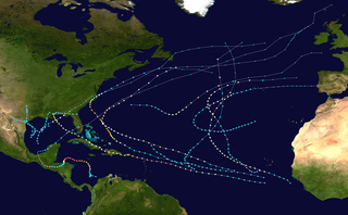
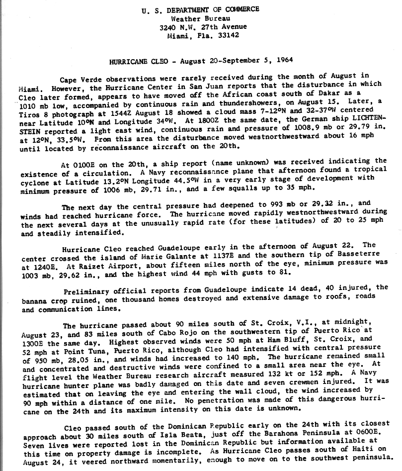
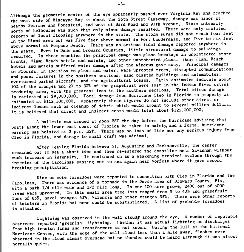
The 1964 Atlantic hurricane season featured the highest number of U.S.-landfalling hurricanes since 1933. The season officially began on June 15, and lasted until November 30. These dates conventionally delimit the period of each year when most tropical cyclones form in the Atlantic basin. The season was above average, with thirteen named storms, seven hurricanes, and five major hurricanes. The first system, an unnamed tropical storm, developed on June 2, almost two weeks before the official start of the season. Striking Florida on June 6, the storm brought localized flooding to portions of Cuba and the Southeastern United States, leaving about $1 million in damage. The next storm, also unnamed, developed near the end of July; it did not impact land.

The 1966 Atlantic hurricane season saw the Weather Bureau office in Miami, Florida, be designated as the National Hurricane Center (NHC) and assume responsibility of tropical cyclone forecasting in the basin. The season officially began on June 1, and lasted until November 30. These dates conventionally delimit the period of each year when most tropical cyclones form in the Atlantic basin. It was an above-average season in terms of tropical storms, with a total of 15. The first system, Hurricane Alma, developed over eastern Nicaragua on June 4 and became a rare major hurricane in the month of June. Alma brought severe flooding to Honduras and later to Cuba, but caused relatively minor impact in the Southeastern United States. Alma resulted in 90 deaths and about $210 million (1966 USD) in damage.

The 1975 Atlantic hurricane season was a near average hurricane season with nine named storms forming, of which six became hurricanes. Three of those six became major hurricanes, which are Category 3 or higher systems on the Saffir–Simpson scale. The season officially began on June 1 and lasted until November 30. These dates conventionally delimit the period of each year when most tropical cyclones form in the Atlantic Ocean.

The 1979 Atlantic hurricane season was the first Atlantic hurricane season to include both male and female names on its list of tropical cyclone names. The season officially began on June 1, and lasted until November 30. These dates conventionally delimit the period of each year when most tropical cyclones form in the Atlantic basin. It was slightly below average, with nine systems reaching tropical storm intensity. The first system, an unnumbered tropical depression, developed north of Puerto Rico on June 9. Two days later, Tropical Depression One formed and produced severe flooding in Jamaica, with 41 deaths and about $27 million (1979 USD) in damage. Tropical Storm Ana caused minimal impact in the Lesser Antilles. Hurricane Bob spawned tornadoes and produced minor wind damage along the Gulf Coast of the United States, primarily in Louisiana, while the remnants caused flooding, especially in Indiana. Tropical Storm Claudette caused extensive flooding in Texas due to torrential rainfall, resulting in two deaths and about $750 million in damage.

The 1949 Atlantic hurricane season was the last season that tropical cyclones were not publicly labeled by the United States Weather Bureau. It officially began on June 15, and lasted until November 15. These dates conventionally delimit the period of each year when most tropical cyclones form in the Atlantic basin. The first storm, a tropical depression, developed in the northern Gulf of Mexico on August 14. The final system, Tropical Storm Sixteen, dissipated in the southwestern Caribbean Sea on November 5. It was a fairly active season, featuring 16 tropical storms and seven hurricanes. Two of these strengthened into major hurricanes, which are Category 3 or higher on the Saffir–Simpson hurricane wind scale.

Hurricane Isbell was the final hurricane to affect the United States during the 1964 season. The eleventh tropical storm and sixth hurricane of the season, Isbell developed from a dissipating cold front in the southwestern Caribbean on October 8. The depression initially remained disorganized as it track northwestward, but strengthened into Tropical Storm Isbell on October 13. Re-curving northeastward, Isbell quickly strengthened further and reached hurricane status by later that day. Late on October 13, Isbell made landfall in the Pinar del Río Province of Cuba. The storm continued strengthening and peaked as a Category 3 hurricane on the following day. Isbell moved northeastward and made landfall near Everglades, Florida, late on October 14. After reaching the Atlantic on the following day, the storm began to weaken. Isbell turned northward and continued weakening, before transitioning to an extratropical cyclone while located just offshore eastern North Carolina on October 16.

The 1901 Atlantic hurricane season was the most active season without a major hurricane – tropical cyclones that reach at least Category 3 on the Saffir–Simpson hurricane wind scale – until 2013. The first system was initially observed in the northeastern Caribbean on June 11. The fourteenth and final system transitioned into an extratropical cyclone near Bermuda on November 5. These dates fall within the period with the most tropical cyclone activity in the Atlantic. Eight of the fourteen tropical cyclones existed simultaneously.

The 1899 Atlantic hurricane season featured the longest-lasting tropical cyclone in the Atlantic basin on record. There were nine tropical storms, of which five became hurricanes. Two of those strengthened into major hurricanes, which are Category 3 or higher on the modern day Saffir–Simpson scale. The first system was initially observed in the northeastern Gulf of Mexico on June 26. The tenth and final system dissipated near Bermuda on November 10. These dates fall within the period with the most tropical cyclone activity in the Atlantic. In post-season analysis, two tropical cyclones that existed in October were added to HURDAT – the official Atlantic hurricane database. At one point during the season, September 3 through the following day, a set of three tropical cyclones existed simultaneously.

Hurricane Gordon was an erratic, long-lived, and catastrophic late-season hurricane of the 1994 Atlantic hurricane season. The twelfth and final tropical cyclone of the season, Gordon formed as a tropical depression in the southwestern Caribbean on November 8. Without strengthening, the depression made landfall on Nicaragua. Later on November 10, the system began to strengthen as it tracked further from land, and it quickly strengthened into Tropical Storm Gordon, the seventh named storm that season. Gordon also made landfalls in Jamaica and Cuba while a minimal tropical storm. It entered the southwestern Atlantic while resembling a subtropical cyclone. By the time it entered the Gulf of Mexico, the storm was fully tropical again. Tropical Storm Gordon later crossed the Florida Keys, and turning to the northeast it made landfall in Fort Myers, Florida. Gordon strengthened after it re-entered the Atlantic Ocean, becoming a hurricane on November 17. It briefly threatened North Carolina while turning to the northwest, although it turned to the south and weakened. Gordon deteriorated into a tropical depression and struck Florida again at that intensity on November 20. It turned to the north and dissipated the next day over South Carolina.

Hurricane Ernesto was the costliest tropical cyclone of the 2006 Atlantic hurricane season. The sixth tropical storm and first hurricane of the season, Ernesto developed from a tropical wave on August 24 in the eastern Caribbean Sea. Ernesto first affected the northern Caribbean, reaching minimal hurricane status near Haiti before weakening and moving across eastern Cuba as a tropical storm. Despite initial predictions for it to track through the eastern Gulf of Mexico as a major hurricane, Ernesto moved across eastern Florida as a weak tropical storm. After turning to the northeast, it re-intensified and made landfall on August 31 on the North Carolina coast just below hurricane status. Late the next day, Ernesto became extratropical after entering southern Virginia. The remnants spread moisture across the northeastern United States before dissipating over eastern Canada on September 4.

The 1987 Atlantic hurricane season was a below-average hurricane season that was limited by an ongoing El Niño. The season officially began on June 1, 1987, and lasted until November 30, 1987, although activity began on May 24 when a tropical depression developed 400 mi (640 km) east of the central Bahamas. The June through November dates conventionally delimit the period of each year when most tropical cyclones form in the Atlantic basin. The first cyclone to attain tropical storm status was an unnamed tropical storm which formed on August 9, nearly a month later than usual. The final storm of the year, Tropical Depression Fourteen, merged with a weak extratropical low on November 4. The season marked the first year tropical storm watches and warnings were issued; previously, gale watches and warnings were used for tropical storms, and this season was one of only a few seasons with no deaths in the United States; the last time this happened was in the 1981 season.

Hurricane Noel was a deadly tropical cyclone that carved a path of destruction across the Atlantic Ocean from the Caribbean Sea to Newfoundland in late October 2007. The sixteenth tropical depression, fourteenth named storm, and the sixth hurricane of the 2007 Atlantic hurricane season, Noel formed on October 27 from the interaction between a tropical wave and an upper-level low in the north-central Caribbean. It strengthened to winds of 60 mph (97 km/h) before making landfall on western Haiti and the north coast of eastern Cuba. Noel turned northward, and on November 1, it attained hurricane status. The hurricane accelerated northeastward after crossing the Bahamas, and on November 2, it transitioned into an extratropical cyclone.

The 1924 Atlantic hurricane season featured the first officially recorded Category 5 hurricane, a tropical cyclone with maximum sustained winds exceeding 155 mph (249 km/h) on the modern-day Saffir–Simpson scale. The first system, Tropical Storm One, was first detected in the northwestern Caribbean Sea on June 18. The final system, an unnumbered tropical depression, dissipated on November 24. These dates fall within the period with the most tropical cyclone activity in the Atlantic. Of the 13 tropical cyclones of the season, six existed simultaneously. The season was average with 11 tropical storms, five of which strengthened into hurricanes. Further, two of those five intensified into major hurricanes, which are Category 3 or higher on the Saffir–Simpson scale.

Hurricane Hanna was a moderately powerful but deadly tropical cyclone that caused extensive damage across the Western Atlantic, mostly in the Turks and Caicos Islands and the East Coast of the United States. The eighth named storm and fourth hurricane of the 2008 Atlantic hurricane season. It formed east-northeast of the northern Leeward Islands on August 28. Initially, the storm struggled to intensify due to moderate wind shear as it moved westwards towards the Bahamas. By August 31, Hanna had drifted southwards and began intensifying while over the Bahamas; it attained its peak intensity as a Category 1 hurricane while over the Turks and Caicos Islands. Due to the outflow of the nearby Hurricane Gustav, Hanna weakened back into a tropical storm the next day as it began to drift northwestwards towards the Southeastern United States. The storm struck Myrtle Beach, South Carolina, before moving up the Eastern Seaboard to become an extratropical cyclone as it moved by New England into Atlantic Canada early on September 7. The system raced across the North Atlantic, sweeping west of Great Britain on September 10 before turning north and becoming absorbed by a stronger extratropical cyclone between Iceland and Greenland late on September 12.

Tropical Storm Dottie was the ninth tropical cyclone and fourth named storm of the 1976 Atlantic hurricane season. The precursor to Dottie formed in the Gulf of Mexico on August 17 and organized into a tropical depression on August 18. The storm drifted towards the east, and, after peaking as a moderate tropical storm, it accelerated northeastward and made landfall on Florida. Upon re-emerging in the Atlantic, Dottie turned northward and moved ashore near Charleston, South Carolina. Damage from the storm was primarily insignificant and limited to gusty winds, heavy rainfall, and high tides; however, a fishing boat capsized in the Bahamas, resulting in the deaths of four people.

Hurricane Edith brought flooding and wind damage to portions of the Greater and Lesser Antilles. The sixth tropical storm and fifth hurricane of the 1963 season, Edith developed east of the Windward Islands on September 23 from an Intertropical Convergence Zone (ITCZ) disturbance. Initially a tropical depression, it strengthened into Tropical Storm Edith the next day. Shortly thereafter, Edith reached hurricane status. Edith fluctuated between Category 1 and 2 status as it moved west-northwest. Upon reaching Category 2 intensity on September 25, the storm peaked with winds of 100 mph (155 km/h). After striking Saint Lucia on September 25, the storm traversed the eastern Caribbean Sea. Curving north-northwest on September 26, Edith made landfall near La Romana, Dominican Republic, early on the following day as a minimal hurricane. Interaction with land and an upper-level trough caused Edith to weaken to a tropical storm on September 28 and to a tropical depression by the next day. The storm dissipated just east of the Bahamas on September 29.


