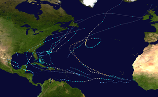
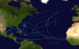
The 1961 Atlantic hurricane season was a very active Atlantic hurricane season, with an accumulated cyclone energy (ACE) total of 189. The season, however, was an average one in terms of named storms. The season featured eight hurricanes and a well above average number of five major hurricanes. It was previously thought that the season had a record-tying seven major hurricanes, before the Atlantic hurricane reanalysis project downgraded two storms in 2019. Two Category 5 hurricanes were seen in 1961, making it one of only seven Atlantic hurricane seasons to feature multiple Category 5 hurricanes in one season. The season started on June 15, and ended on November 15. These dates conventionally delimit the period of each year when most tropical cyclones form in the Atlantic basin. The first system, an operationally unclassified tropical depression, formed offshore east Central Florida on June10, but dissipated a few days later. Next, Hurricane Anna developed in the eastern Caribbean Sea near the Windward Islands on July20. It brought minor damage to the islands, as well as wind and flood impacts to Central America after striking Belize as a hurricane.[nb 1] Anna caused one death and about $300,000 (1961USD)[nb 2] in damage. Activity went dormant for nearly a month and a half, until Hurricane Betsy developed on September2. Betsy peaked as a Category4 hurricane, but remained at sea and caused no impact.
One of the most significant storms of the season was Hurricane Carla, which peaked as a Category4 hurricane, before striking Texas. Carla caused 43deaths and approximately $325.74million in damage. Hurricane Debbie was a Category1 storm that existed in the eastern Atlantic Ocean. Early in its duration, unsettled weather from Debbie in Cape Verde resulted in a plane crash that killed 60people. The extratropical remnants of Debbie then brushed Ireland, causing severe damage over the British Isles. The next storm, Hurricane Esther, threatened to strike New England as a major hurricane, but rapidly weakened and made landfall in Massachusetts as only a tropical storm. Impact was generally minor, with about $6million in damage and seven deaths, all of which from a United States Navy plane crash. An unnamed tropical storm and Hurricane Frances caused minimal impact on land. In mid-October, Tropical Storm Gerda brought flooding to Jamaica and eastern Cuba, resulting in twelve deaths.
Another significant storm was Hurricane Hattie, a late-season Category5 hurricane that struck Belize. Hattie caused 319confirmed fatalities and about $60.3million in damage. Destruction was so severe in Belize that the government had to relocate inland to a new city, Belmopan. In early November, the depression that would later strengthen into Hurricane Jenny brought light rainfall to Puerto Rico. The final storm, Tropical Storm Inga, dissipated on November8, after causing no impact on land. On September11, three hurricanes existed simultaneously – Betsy, Carla, and Debbie – the most on a single day in the Atlantic basin since 1893 and until 1998. Collectively, the storms of the 1961Atlantic hurricane season caused about $392.34million in damage and at least 437fatalities.
The Atlantic hurricane season officially began on June15.[1] It was an above average season in which twelve tropical storms formed; this was above the 1950–2000average of 9.6named storms.[2] Eight of these reached hurricane status, also above of the 1950–2000average of 5.9.[3][2] Furthermore, five storms reached major hurricane status. It was originally believed that the season had seven major hurricanes, though later analysis resulted in a downgrade of two storms.[4] Of the five major hurricanes, two became Category5 hurricanes. Four hurricanes and two tropical storms made landfall during the season,[3] causing 348deaths and $391.6million in damage.[5] Hurricane Debbie also caused damage and deaths, despite remaining offshore and then after becoming extratropical.
Tropical cyclogenesis began with an initially unclassified tropical depression, which developed on June10.[6] More than a month later, Hurricane Anna formed on July17 and dissipated on July24. Thereafter, no other systems developed in July or the month of August.[3] A lack of cyclonic activity in the Atlantic basin in August is rare, with such phenomenon not occurring again until the 1997 and 2022 seasons.[7] The Atlantic basin remained dormant until Hurricane Betsy developed on September2. During the next four days, two other tropical cyclones formed – Carla and Debbie. On September11, the three storms – Betsy, Carla, and Debbie – existed simultaneously as hurricanes,[3] the most in a single day since 1893 and until 1998.[8] Esther, which developed on September10, did not reach hurricane status until September12. Later that day, a tropical storm that went unnamed formed over the Bahamas and moved across the East Coast of the United States for its brief duration.[3][9]
After Debbie became extratropical on September14, another tropical cyclone developed over two weeks later, Hurricane Frances. Thereafter, tropical cyclogenesis slowed in October, which featured only three systems, a second previously unclassified tropical depression, Gerda, and Hattie. The latter was the strongest tropical cyclone of the season, peaking with maximum sustained winds of 165mph (266km/h) and a minimum barometric pressure of 914mbar (27.0inHg). After weakening slightly, Hattie struck Belize on October31, before dissipating on November1. Later that day, Hurricane Jenny developed northeast of Antigua. Jenny remained weak for much of its duration and became extratropical on November8. The final system, Tropical Storm Inga, formed in the Gulf of Mexico on November4. Four days later, Inga dissipated,[3] one week before the season officially ended.[1]
The season's activity was reflected with an accumulated cyclone energy (ACE) rating of 189, one of the highest values recorded. ACE is, broadly speaking, a measure of the power of the hurricane multiplied by the length of time it existed, so storms that last a long time, as well as particularly strong hurricanes, have high ACEs. It is only calculated for full advisories on tropical systems at or exceeding 39mph (63km/h), which is the threshold for tropical storm strength.[4]
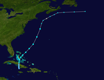
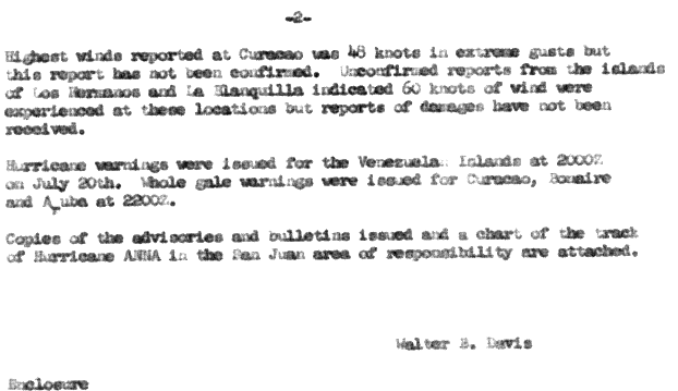
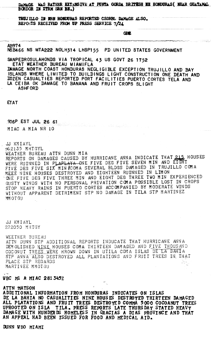
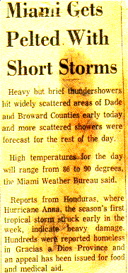
A tropical wave that emerged into the Atlantic from the west coast of Africa around mid-July developed about 575mi (925km) northeast of Cayenne, French Guiana, late on July17.[6]:2[3] The depression moved west-northwestward and by the following day, it intensified into a Tropical Storm Anna. After passing just south of Grenada early on July20, Anna entered the Caribbean Sea. Favorable environmental conditions allowed Anna to reach hurricane intensity late on July20. The cyclone continued to slowly intensifying, reaching Category2 intensity on July22 and peaking with maximum sustained winds of 105mph (169km/h). However, the storm weakened slightly before making landfall as a Category1 hurricane in Honduras near Barra Patuca, Gracias a Dios Department, with winds of 80mph (130km/h). After re-emerging into the Caribbean, Anna weakened slightly further, striking Utila around 01:00UTC on July24 with winds of 75mph (121km/h). About nine hours later, the hurricane made landfall in Belize near Monkey River Town at the same intensity. Anna rapidly weakened over land and dissipated late on July24.[3]
As a developing tropical cyclone over the Windward Islands, Anna produced strong winds on Grenada, though damage was limited to some crops, trees, and telephone poles.[10] Other islands experienced gusty winds, but no damage. Passing just north of Venezuela, the hurricane produced strong winds over the country, peaking as high as 70mph (110km/h).[11] Strong winds caused widespread damage in northern Honduras. Throughout the country, at least 36homes were destroyed and 228were damaged.[12] Severe damage in the Gracias a Dios Department left hundreds of people homeless.[13] Additionally, high winds toppled approximately 10,000coconut trees.[12] Overall, Anna caused one fatality and $300,000in damage, primarily in Central America.[14][13]
In early September, a tropical wave was noted in the Intertropical Convergence Zone (ITCZ).[14][15] On September2, the disturbance was analyzed to have attained tropical storm strength, after nearby ship reports indicated strong winds associated with anomalously low barometric pressures.[14] Moving steadily northwestward, favorable conditions allowed Betsy to quickly intensify later that day.[3] Shortly after, a trough situated along 50°W steered Betsy to a more northerly course. Another low-pressure area later formed in the trough, perturbing the ridge to the north of Betsy for much of its initial stages, causing the hurricane's central pressure to rise,[14] despite an increase in sustained winds.[3] However, on September5, a shortwave forced the low northeastward, allowing for Betsy to strengthen further.[14]
Early on September6, Betsy attained Category 4 hurricane strength, peaking with maximum sustained winds of 130mph (210km/h) and a central pressure of 945mbar (945hPa; 27.9inHg),[3] based on reconnaissance flights into the system.[6]:15–16 However, as a result of missing the short wave itself, the hurricane later weakened and fell to Category3 intensity while located about 440 miles (710km) east-northeast of Bermuda. Betsy weakened further to Category2 hurricane before becoming nearly stationary beginning on September6.[14] Moving into higher latitudes, Betsy began to weaken, degenerating back to Category1hurricane intensity on late on September8.[3] A separate, minor trough was later able to move the system northeastwards by the following day.[14] Betsy re-intensified into a Category2 hurricane early on September10, but transitioned into extratropical cyclone several hours later. The extratropical remnants continued northeastward and weakened, before executing a large loop over the far north Atlantic. The remnants dissipated well north of the Azores on September16.[3]
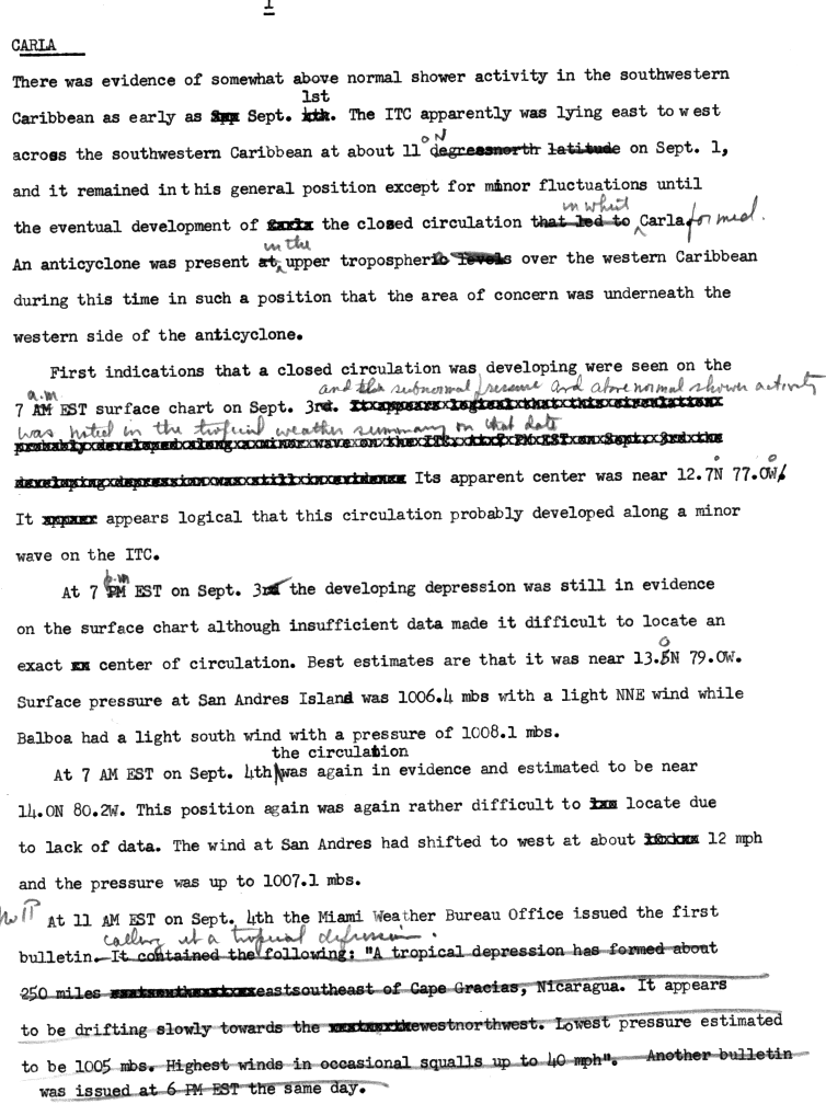
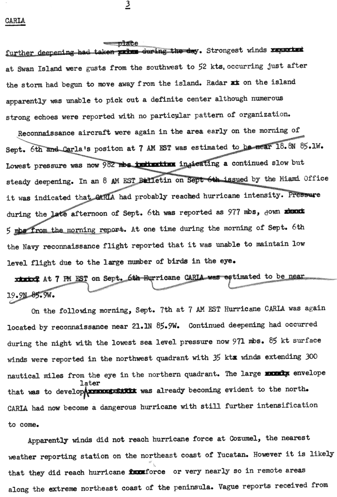
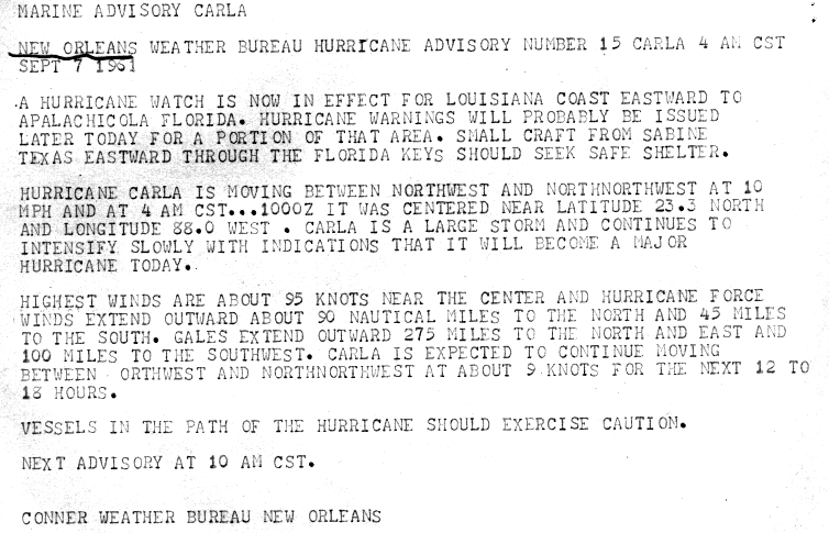
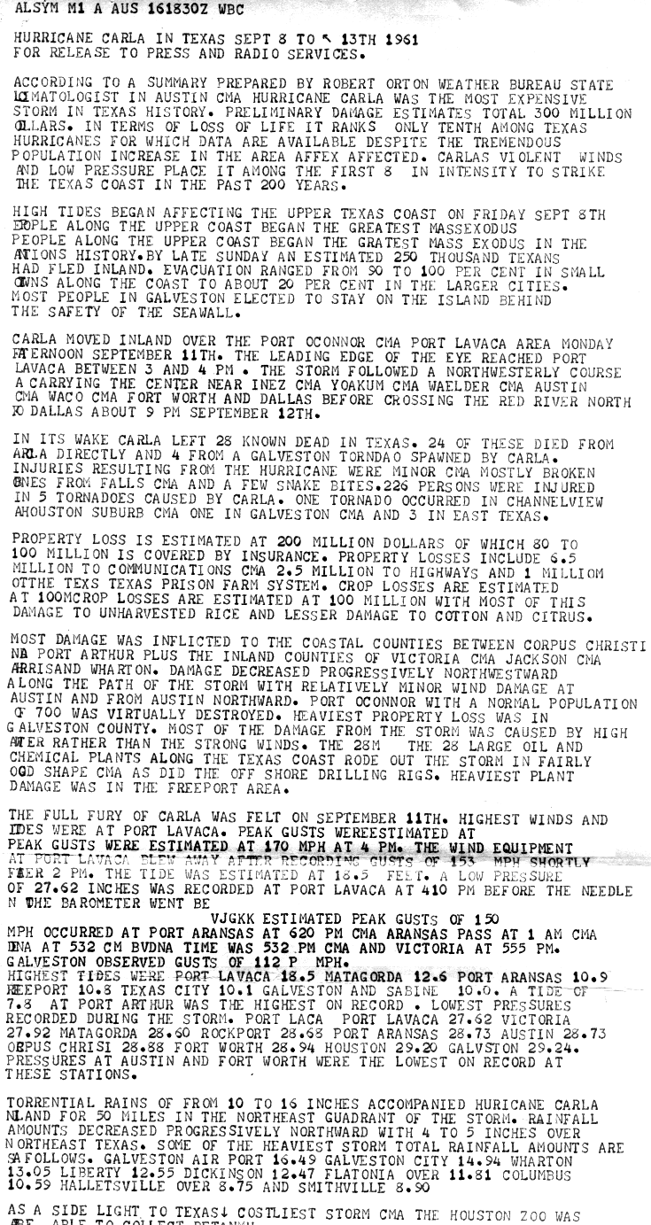
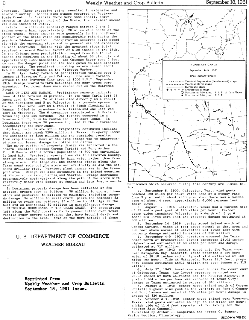
A tropical depression developed from an area of squally weather embedded within the ITCZ in the southwestern Caribbean Sea on September3.[16] Initially a tropical depression, it strengthened slowly while heading northwestward, and by September4, the system was upgraded to Tropical Storm Carla.[3] About 24hours later, Carla was upgraded to a hurricane.[3][17] Shortly thereafter, the storm curved northward while approaching the Yucatán Channel. Late on September7, Carla entered the Gulf of Mexico while passing just northeast of the Yucatán Peninsula. The cyclone reached major hurricane intensity around 12:00UTC on the next day. Resuming its northwestward course, Carla continued intensification and on September11, it peaked as a Category4 hurricane. Carla made landfall near Port O'Connor, Texas, with winds of 145mph (233km/h). It weakened quickly inland and was reduced to a tropical storm on September12. Heading generally northward, Carla transitioned into an extratropical cyclone on September13, while centered over southern Oklahoma. However, the remnants continued generally northeastward and entered Canada on September14, before dissipating near Cape Chidley early on September16.[3]
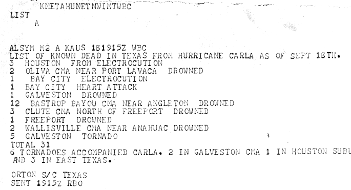
While crossing the Yucatán Channel, the outer bands of Carla brought gusty winds and severe local flooding in western Cuba and the Yucatán Peninsula.[14][18] Although initially considered a significant threat to Florida,[19] the storm brought only light winds and small amounts of precipitation, reaching no more than 3.15in (80mm).[18] In Texas, wind gusts as high as 170mph (270km/h) were observed in Port Lavaca. Additionally, several tornadoes spawned in the state caused notable impacts, with the most destructive tornado striking Galveston, Texas at F4 intensity, resulting in 200buildings being severely damaged, of which 60-75were destroyed, eight deaths and 200injuries.[20] Throughout the state, Carla destroyed 1,915homes, 568farm buildings, and 415other buildings. Additionally, 50,723homes, 5,620farm buildings, and 10,487other buildings suffered damage. There were 34fatalities and at least $300million in losses in Texas alone. Several tornadoes also touched down in Louisiana, causing the destruction of 140homes and 11farms and other buildings, and major damage to 231additional homes and 11farm and other buildings. Minor to moderate damage was also reported to 748homes and 75farm and other buildings.[21] Six deaths and $25million in losses in Louisiana were attributed to Carla.[22] Heavy rainfall occurred in several other states, especially in Kansas,[23] where flash flooding severely damaged crops and drowned five people.[24] Overall, Carla resulted in $325.74million in losses and 46fatalities.[22][24][25] In Canada, the remnants of Carla brought strong winds to Ontario and New Brunswick, though impact was primarily limited to power outages and falling trees and branches.[26]
A tropical disturbance was first identified in late August over Central Africa.[27] The wave developed into a tropical depression just offshore Senegal around 12:00UTC on September5. It was estimated to have intensified into Tropical Storm Debbie early the next day. Several hours later, Debbie passed through the southern Cape Verde Islands as a strong tropical storm or minimal hurricane,[3] resulting in a plane crash that killed 60people.[28] Once clear of the islands, data on the storm became sparse, and the status of Debbie was uncertain over the following several days as it tracked west-northwestward and later northward. It was not until a commercial airliner intercepted the storm on September10 that its location was certain.[29] The following day, Debbie intensified and reached its peak intensity as a strong Category1 hurricane with maximum sustained winds of 90mph (140km/h). The hurricane gradually slowed its forward motion and weakened.[3] By September13, Debbie's motion became influenced by the westerlies, causing the system to accelerate east-northeastward.[29] The storm transitioned into an extratropical cyclone late on September14 about 140mi (225km) west-southwest of Horta, Azores.[3]
The remnants of Debbie soon passed east-northeastward throughout the Azores and then curved northeastward. The system deepened slightly as it neared the British Isles, skirting the coast of Western Ireland on September16.[3] In Ireland, Debbie brought record winds to much of the island, with a peak gust of 114mph (183km/h) measured just offshore.[30] Widespread wind damage and disruption occurred, downing tens of thousands of trees and power lines.[31][32] Countless structures sustained varying degrees of damage, with many smaller buildings destroyed.[33] Agriculture experienced extensive losses to barley, corn and wheat crops.[34] Throughout Ireland, Debbie killed 18people, with 12 in the Republic of Ireland and six in Northern Ireland.[35] The storm also battered parts of Great Britain with winds in excess of 100mph (160km/h).[14]
On September10, Television Infrared Observation Satellite (TIROS) III observed an area of disturbed weather well southwest of the Cape Verde Islands.[14] Later that day, a tropical depression developed about 510 miles (820km) west-southwest of the southernmost Cape Verde Islands. Moving northwestward, the depression strengthened into Tropical Storm Esther on September11, before reaching hurricane intensity on the following day. Early on September13, Esther curved westward and deepened into a major hurricane. The storm remained a Category3 hurricane for about four days and gradually moved in west-northwestward direction. Esther strengthened into a Category4 hurricane on September16 and peaked as a Category5 hurricane on the following day with sustained winds of 160mph (260km/h).[3]
The storm curved north-northeastward on September19, while offshore North Carolina. Esther began to weaken while approaching New England and fell to Category2 intensity early on September21. The storm turned eastward on the following day and gradually weakened to a tropical storm. It then executed a large cyclonic loop, until curving northward on September25. Early on the following day, Esther made two landfalls in Massachusetts, first on Muskeget Island and then near South Yarmouth with winds of 60mph (97km/h). The storm then emerged over the Gulf of Maine and made landfall in Brunswick, Maine, around 11:00UTC on September26 with winds of 40mph (64km/h). Esther weakened to a tropical depression late on September26 before weakening to a tropical depression and becoming extratropical over southeastern Quebec.[3] The remnants persisted for about 12hours, before dissipating early on September27.[3] Between North Carolina and New Jersey effects were primarily limited to strong winds and minor beach erosion and coastal flooding due to storm surge.[36] In New York, strong winds led to severe crop losses and over 300,000power outages. High tides caused coastal flooding and damage a number of pleasure boats. Similar impact was reported in Massachusetts. Additionally, some areas observed more than 8 inches (200mm) of rainfall, flooding basements, low-lying roads, and underpasses.[24] Overall, damage was minor, totaling about $6million.[14] There were also seven deaths reported when United States Navy P5M aircraft crashed about 120 miles (190km) north of Bermuda.[37]
TIROS III imagery indicated a vortex east of the Bahamas between September9 and September12.[9] A tropical depression formed at 12:00UTC on September12 near Great Harbour Cay in the Bahamas,[3] after TIROS revealed a surface circulation.[9] The depression tracked northward and intensified into a tropical storm while located offshore North Carolina. Around 12:00UTC September14, it made landfall in the state near Topsail Beach, North Carolina, with winds of 45mph (72km/h). The storm curved accelerated northeastward and intensified despite mostly remaining over land, striking near the southern tip of the Delmarva Peninsula about nine hours later with winds of 50mph (80km/h). After re-emerging into the Atlantic late on September14, the cyclone made landfall near Islip, New York, with peak winds of 65mph (105km/h) around 06:00UTC on September15, followed by another landfall near Guilford, Connecticut, about an hour later at the same intensity. The cyclone became extratropical over southern Maine around 12:00UTC and quickly dissipated.[3]
Impact from the storm was generally minor. In Savannah, Georgia, the storm produced an F2 tornado that blew the roof off of a lumber company building. In North Carolina, 3.12 inches (79mm) of precipitation fell at Williamston.[38] Strong winds lashed Rhode Island, with winds as high as 70mph (110km/h) in Point Judith. About 29,000homes were left without electricity, while 1,200lost telephone service. Hundreds of small crafts and a few ferries and barges were swamped or sank. Hurricane-force wind gusts in Massachusetts felled trees, electrical wires, and TV antennas. Some roads in the southeastern portion of the state were blocked by fallen trees. Similar impact was reported in Maine, where an F2 tornado/waterspout tracked 19.1 miles (30.7km) from Beals through Roque Bluffs before dissipating in Dog Town just east of East Machias. Power lines were considerably damaged and numerous trees were knocked down, including two incidents where trees fell on and damaged homes. The tornado caused one injury when a man was hit by a flying wooden plank.[24]
A westward-moving tropical wave organized into Tropical Storm Frances on September30, east of the northern Lesser Antilles.[39][3] Six hours later, the depression strengthened into Tropical Storm Frances. Heading westward, it crossed through the Leeward Islands and entered the Caribbean Sea on October1.[3] Thereafter, the lack of divergence at high levels prevented significant strengthening for a few days.[39] While situated south of Puerto Rico on October2, Frances curved northwestward.[3] The storm brought heavy rainfall to Puerto Rico, peaking at 10.15 inches (258mm) in the Indiera Baja barrio of Maricao.[38] Considerable damage to roads and bridges occurred. However, due to swift evacuations of residents by the Civil Defense and American Red Cross, no fatalities were reported.[39]
Tracking to the northwest, Frances made landfall near Punta Cana, Dominican Republic, early on October3 with winds of 60mph (97km/h). No impact was reported on the island. Later on October3, Frances emerged into the Atlantic Ocean just southeast of the Turks and Caicos Islands. Thereafter, the storm accelerated somewhat and resumed intensification, reaching hurricane status on October4. Around that time, it curved northeastward and deepened further. Early on October7, Frances attained its peak intensity with winds of 130mph (210km/h) and a minimum barometric pressure of 948mbar (28.0inHg).[3] The storm passed by Bermuda around that time, where it dropped 1.35 inches (34mm) of precipitation.[38] Later on October7, Frances re-curved to the north. Early on the following day, the storm became extratropical as it approached the Gulf of Maine. The remnants curved east-northeastward and struck Nova Scotia, before dissipating early on October10.[3]
A westward-moving tropical wave reached the central Caribbean by mid-October.[14] The wave crossed Jamaica, causing flooding that damaged roads and forced many to evacuate their homes in western Kingston. Five fatalities were reported in Jamaica.[40] Early on October17, the wave developed into a tropical depression just southwest of Cape Cruz, Cuba. It continued northward and made another landfall near Santa Cruz del Sur several hours later.[3] The depression also brought heavy rainfall to eastern Cuba, which resulted in seven deaths.[14] After striking Cuba, the depression emerged into the Atlantic early on October18 as it intensified into Tropical Storm Gerda.[3]
Moving across the Bahamas later on October18, Gerda accelerated to the north-northeast. The storm curved northeastward on October20, while peaking with winds of 70mph (110km/h).[3] However, a Texas Tower offshore Massachusetts observed hurricane-force winds.[14] At 00:00UTC on October20, Gerda transitioned into an extratropical cyclone while situated about 165 miles (265km) southeast of Nantucket, Massachusetts.[3] Damage from the storm in New England was "about the same as that from a typical wintertime northeaster".[14] The remnants of Gerda moved northeastward and then to the east, before dissipating between Newfoundland and the Azores late on October22.[3]
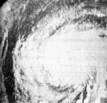
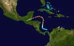
In late October, an area of low pressure persisted in the western Caribbean Sea for several days.[41] Around 00:00UTC on October26, a tropical depression developed about 100mi (160km) northeast of Colón, Panama. Approximately 12hours later, the depression intensified into Tropical Storm Hattie. Moving towards the north and north-northeast, the storm quickly gained hurricane status early on October28 and reached major hurricane intensity that same day. Hattie turned towards the west to the east of Jamaica and strengthened into a Category 5 hurricane with maximum sustained winds of 165mph (266km/h) on October31. The storm then weakened to a Category 4 hurricane prior to landfall south of Belize City, British Honduras, with winds of 150mph (240km/h). Continuing southwest, the storm rapidly weakened over the mountainous terrain of Central America, dissipating on November1.[3] It was originally thought that the remnants may have contributed to the development of Tropical Storm Simone in the eastern Pacific Ocean, but a 2019 reanalysis concluded that the remnants of Hattie instead became a Central American gyre.[6]
Hattie first affected regions in the southwestern Caribbean, producing hurricane-force winds and causing one death on San Andres Island.[14] It was initially forecast to continue north and strike Cuba, which prompted evacuations.[42] Little effects were reported as Hattie turned to the west, although rainfall reached 11.5in (290mm) on Grand Cayman.[41] The worst damage was in the country of Belize. The former capital, Belize City, was flooded by a powerful storm surge and high waves and affected by strong winds. The territory governor estimated 70% of the buildings in the city were damaged, which left over 10,000people homeless.[43] The damage was severe enough that it prompted the government to relocate inland to a new city, Belmopan.[44] In the territory, Hattie left about $60million in damage and caused 307deaths.[14][45] The government estimated that Hattie was more damaging than a hurricane in 1931 that killed 2,000people; the lower toll for Hattie was due to advance warning. Elsewhere in Central America, the hurricane killed 11people in Guatemala and one in Honduras.[14]
A surface trough of low pressure developed in the eastern Caribbean Sea on October30. The trough split, with the northern portion spawning a tropical depression near Antigua at 00:00UTC on November2.[3][46] The precursor to Jenny brought light rainfall to Puerto Rico, peaking at 4.97 inches (126mm) in Río Blanco, Naguabo.[46] Moving northeastward ahead of an upper-level trough, the depression remained weak for over three days. On November3, the system curved eastward, before briefly turning to the southeast on November4. The depression tracked in a circular path during the next 24hours, moving northeastward, north-northwestward, and then west-northward. Finally, the system strengthened into Tropical Storm Jenny early on November5.[3]
Jenny intensified further and reached hurricane status at 12:00UTC on November6. Later that day, the United States Weather Bureau began advisories and described Jenny as having "characteristic of many storms in the sub-tropics late in the hurricane season."[47] Around 18:00UTC on November6, Jenny attained its peak intensity with maximum sustained winds of 80mph (130km/h) and a minimum barometric pressure of 974mbar (28.8inHg). Thereafter, the storm briefly decelerated and weakened, falling to tropical storm intensity around midday on November7. Jenny curved northeastward and continued to weaken, transitioning into an extratropical cyclone late on November10 about 545mi (875km) east of Cape Race, Newfoundland.[3] The extratropical remnants continued to move northeastward and weakened before being absorbed by a larger extratropical cyclone on the following day.[6]:97
Early on November4, the SS Navigator encountered a weather system in the Gulf of Mexico that produced northwesterly winds of 81 to 92mph (130 to 148km/h). Reconnaissance aircraft data indicated that Tropical Storm Inga developed at 00:00UTC on November4,[14] while located about 145 miles (235km) northeast of Veracruz.[3] A strong high pressure system and a cold front entering the Gulf of Mexico from Texas caused the storm to move southward and then southeastward. Inga slowly strengthened and peaked as a 70mph (110km/h) tropical storm early on November7. Thereafter, the storm became nearly stationary and began weakening.[14] By 12:00UTC on November8, Inga dissipated in the Bay of Campeche,[3] as reconnaissance aircraft found no closed circulation.[14]
A stationary front across the central Atlantic Ocean led to the development of a low pressure area by November16, northeast of the Lesser Antilles. A day later, it is estimated that a tropical depression developed, although due to the system's large size, it was possible it was a subtropical cyclone. The depression moved northeastward and slowly intensified, based on observations from nearby ships. On November19, the depression strengthened into a tropical storm. The storm strengthened to reach peak winds of 60mph (97km/h) on November20. By that time, a cold front was approaching the storm, causing the storm to transition into an extratropical cyclone on November21; later that day, the front absorbed the former tropical storm.[6]
Other storms
In addition to the twelve systems reaching at least tropical storm status, two other cyclones formed but remained at tropical depression intensity. The first such system, also the first tropical cyclone of the season, originated from a tropical wave about 35mi (55km) east of Palm Bay, Florida, on June10. Moving quickly northeastward, the depression may have reached tropical storm intensity on June12 but degenerated into a trough offshore New England on the next day.[6]:108 On October12, a trough developed into a tropical depression about halfway between Bermuda and North Carolina. This depression also moved quickly northeastward and merged with a frontal boundary by October15.[6]:109
A report from Mexico indicates that a tropical depression formed off the west coasts of Tabasco and Coatzacoalcos. The depression significantly impacted the northern portions of Veracruz with heavy rainfall on June30.[48] However, the Atlantic hurricane best track does not list this system as a tropical depression.[3]
Storm names
The following list of names was used for named storms (tropical storms and hurricanes) that formed in the North Atlantic in 1961.[49] Storms were named Frances, Hattie, Inga and Jenny for the first time in 1961.
The names Carla and Hattie were retired after the season due to their severity of impacts.[50] They were replaced with Carol and Holly, respectively, for the 1965 season.[51]
Season effects
This is a table of all of the storms that formed in the 1961 Atlantic hurricane season. It includes their name, duration, peak classification and intensities, areas affected, damage, and death totals. Deaths in parentheses are additional and indirect (an example of an indirect death would be a traffic accident), but were still related to that storm. Damage and deaths include totals while the storm was extratropical, a wave, or a low, and all of the damage figures are in 1961 USD.
The 2000 Atlantic hurricane season was a fairly active hurricane season, but featured the latest first named storm in a hurricane season since 1992. The hurricane season officially began on June 1, and ended on November 30. It was slightly above average due to a La Niña weather pattern although most of the storms were weak. It was also the only season to have two of the storms affect Ireland. The first cyclone, Tropical Depression One, developed in the southern Gulf of Mexico on June 7 and dissipated after an uneventful duration. However, it would be almost two months before the first named storm, Alberto, formed near Cape Verde; Alberto also dissipated with no effects on land. Several other tropical cyclones—Tropical Depression Two, Tropical Depression Four, Chris, Ernesto, Nadine, and an unnamed subtropical storm—did not impact land. Five additional storms—Tropical Depression Nine, Florence, Isaac, Joyce, and Leslie—minimally affected land areas.
The 1960 Atlantic hurricane season was the least active season since 1952. The season officially began on June 15, and lasted until November 15. These dates conventionally delimit the period of each year when most tropical cyclones form in the Atlantic basin. The first system, an unnamed storm, developed in the Bay of Campeche on June 22. It brought severe local flooding to southeastern Texas and was considered the worst disaster in some towns since a Hurricane in 1945. The unnamed storm moved across the United States for almost a week before dissipating on June 29. In July, Hurricane Abby resulted in minor damage in the Leeward Islands, before impacting a few Central American counties — the remnants of the storm would go on to form Hurricane Celeste in the East Pacific. Later that month, Tropical Storm Brenda caused flooding across much of the East Coast of the United States. The next storm, Hurricane Cleo, caused no known impact, despite its close proximity to land.
The 1964 Atlantic hurricane season featured the highest number of U.S.-landfalling hurricanes since 1933. The season officially began on June 15, and lasted until November 30. These dates conventionally delimit the period of each year when most tropical cyclones form in the Atlantic basin. The season was above average, with thirteen named storms, seven hurricanes, and five major hurricanes. The first system, an unnamed tropical storm, developed on June 2, almost two weeks before the official start of the season. Striking Florida on June 6, the storm brought localized flooding to portions of Cuba and the Southeastern United States, leaving about $1 million in damage. The next storm, also unnamed, developed near the end of July; it did not impact land.
The 1965 Atlantic hurricane season was the first to use the modern-day bounds for an Atlantic hurricane season, which are June 1 to November 30. These dates conventionally delimit the period of each year when most tropical cyclones form in the Atlantic basin. It was a slightly below average season, with 10 tropical cyclones developing and reaching tropical storm intensity. Four of the storms strengthened into hurricanes. One system reached major hurricane intensity – Category 3 or higher on the Saffir–Simpson hurricane scale. The first system, an unnamed tropical storm, developed during the month of June in the southern Gulf of Mexico. The storm moved northward across Central America, but caused no known impact in the region. It struck the Florida Panhandle and caused minor impact across much of the Southern United States. Tropical cyclogenesis halted for over two months, until Anna formed on August 21. The storm remained well away from land in the far North Atlantic Ocean and caused no impact.
The 1966 Atlantic hurricane season saw the Weather Bureau office in Miami, Florida, be designated as the National Hurricane Center (NHC) and assume responsibility of tropical cyclone forecasting in the basin. The season officially began on June 1, and lasted until November 30. These dates conventionally delimit the period of each year when most tropical cyclones form in the Atlantic basin. It was an above-average season in terms of tropical storms, with a total of 15. The first system, Hurricane Alma, developed over eastern Nicaragua on June 4 and became the most recent major hurricane in the month of June. Alma brought severe flooding to Honduras and later to Cuba, but caused relatively minor impact in the Southeastern United States. Alma resulted in 90 deaths and about $210.1 million (1966 USD) in damage.
The 1968 Atlantic hurricane season was a below average hurricane season during which only nine nameable storms developed. The season officially began on June 1 and lasted until November 30, dates which conventionally delimit the period of each year when most tropical cyclones form in the Atlantic basin. Of the named storms, five strengthened into hurricanes; none however intensified into a major hurricane. Only four other seasons since the start of the satellite era—1972, 1986, 1994, and 2013—did not feature a major hurricane. The first system, Hurricane Abby, developed in the northwestern Caribbean on June 1. Abby moved northward and struck Cuba, bringing heavy rainfall and flooding to western portions of the island. Making landfall in Florida on June 4, Abby caused flooding and spawned four tornadoes, but left behind little damage. Overall, the hurricane resulted in six deaths and about $450,000 (1968 USD) in damage. In late June, Tropical Storm Candy brought minor flooding and spawned several tornadoes across portions of the Southern United States. Overall damage from the cyclone reached approximately $2.7 million. 1968 featured two simultaneously active tropical storms during the month of June, a phenomenon that would not occur again until 2023.
The 1969 Atlantic hurricane season was the most active Atlantic hurricane season since the 1933 season, and was the final year of the most recent positive ("high-quality") Atlantic multidecadal oscillation (AMO) era. The hurricane season officially began on June 1, and lasted until November 30. Altogether, 12 tropical cyclones reached hurricane strength, the highest number on record at the time; a mark not surpassed until 2005. The season was above-average despite an El Niño, which typically suppresses activity in the Atlantic Ocean, while increasing tropical cyclone activity in the Pacific Ocean. Activity began with a tropical depression that caused extensive flooding in Cuba and Jamaica in early June. On July 25, Tropical Storm Anna developed, the first named storm of the season. Later in the season, Tropical Depression Twenty-Nine caused severe local flooding in the Florida Panhandle and southwestern Georgia in September.
The 1972 Atlantic hurricane season was a significantly below average season, having only seven named storms, four fully tropical storms and three subtropical storms. It officially began on June 1, 1972, and lasted until November 30, 1972. These dates conventionally delimit the period of each year when most tropical cyclones form in the Atlantic basin. The first storm, Subtropical Storm Alpha, developed on May 23 off the Southeast United States and struck Florida, causing minor damage and two fatalities.
The 1978 Atlantic hurricane season was a slightly above average hurricane season in terms of number of named storms. Eleven tropical cyclones were named in all, and five of these became hurricanes; two of the five became a major hurricane. This was also the last Atlantic hurricane season to use an all-female naming list. The season officially began on June 1, 1978, and ended on November 30, 1978. These dates, adopted by convention, denote the period in each year when most tropical cyclogenesis occurs in the Atlantic basin. However, the formation of subtropical or tropical cyclones is possible at any time of the year, as shown by the formation of an unnamed subtropical storm on January 18.
The 1957 Atlantic hurricane season featured one of the longest-travelling tropical cyclones in the Atlantic basin, Hurricane Carrie. Nevertheless, the season was generally inactive, with eight tropical storms – two of which went unnamed – and three hurricanes, two of which intensified further to attain major hurricane intensity. The season officially began on June 15 and ended on November 15, though the year's first tropical cyclone developed prior to the start of the season on June 8. The final storm dissipated on October 27, well before the official end of the season. The strongest hurricane of the year was Carrie, which reached the equivalent of a Category 4 hurricane on the Saffir–Simpson hurricane scale on two separate occasions in the open Atlantic; Carrie later caused the sinking of the German ship Pamir southwest of the Azores, resulting in 80 deaths.
The 1936 Atlantic hurricane season was a fairly active season, with 20 tropical cyclones recorded, 17 of which became tropical storms. Seven storms became hurricanes, of which one became a major hurricane. In addition, the season was unusual in the fact that no storms moved across large portions of the Caribbean Sea. Seven storms, including three hurricanes, struck the United States.
The 1929 Atlantic hurricane season was among the least active Atlantic hurricane seasons on record, with only five tropical cyclones forming. Three of them intensified into a hurricane, with one strengthening further into a major hurricane. The first tropical cyclone of the season developed in the Gulf of Mexico on June 27. Becoming a hurricane on June 28, the storm struck Texas, bringing strong winds to a large area. Three fatalities were reported, while damage was conservatively estimated at $675,000 (1929 USD).
The 1920 Atlantic hurricane season featured tropical storms and hurricanes only in the month of September. The first system, a hurricane, developed on September 7 while the last, a tropical depression, transitioned into an extratropical cyclone on October 27. Of note, four of the six cyclones co-existed with another tropical cyclone during the season.
The 1919 Atlantic hurricane season was among the least active hurricane seasons in the Atlantic on record, featuring only five tropical storms. Of those five tropical cyclones, two of them intensified into a hurricane, with one strengthening into a major hurricane Two tropical depressions developed in the month of June, both of which caused negligible damage. A tropical storm in July brought minor damage to Pensacola, Florida, but devastated a fleet of ships. Another two tropical depressions formed in August, the first of which brought rainfall to the Lesser Antilles.
The 1917 Atlantic hurricane season featured nine known tropical cyclones, four of which became tropical storms. The first system appeared on July 6 east of the Windward Islands. After crossing the islands and traversing the Caribbean Sea, the storm struck Honduras, Belize, and Mexico, before dissipating on July 14. After more than three weeks without tropical cyclogenesis, another tropical storm developed west of Bermuda. As the storm brushed eastern New England, four ships sank near Nantucket, causing 41 fatalities. The same cyclone brought damaging winds to Nova Scotia before transitioning into an extratropical cyclone on August 10.
The 1905 Atlantic hurricane season featured five known tropical cyclones, two of which made landfall in the United States. The first system was initially observed near the Windward Islands on September 6. The last system to dissipate, the fourth storm, transitioned into an extratropical cyclone on October 11, while located well southeast of Newfoundland. These dates fall within the period with the most tropical cyclone activity in the Atlantic. Between October 5 and October 10, the fourth and fifth system existed simultaneously.
The 1901 Atlantic hurricane season was the most active season without a major hurricane – tropical cyclones that reach at least Category 3 on the Saffir–Simpson hurricane wind scale – until 2013. The first system was initially observed in the northeastern Caribbean on June 11. The fourteenth and final system transitioned into an extratropical cyclone near Bermuda on November 5. These dates fall within the period with the most tropical cyclone activity in the Atlantic. Eight of the fourteen tropical cyclones existed simultaneously.
The 1900 Atlantic hurricane season featured the Galveston hurricane, the deadliest natural disaster in the history of the United States. A total of 10 tropical cyclones formed, seven of which intensified into a tropical storm. Three of those made landfall in the United States. The first system was initially observed over the central Atlantic Ocean on January 17, while the final storm transitioned into an extratropical cyclone on October 28. These dates fall within the period with the most tropical cyclone activity in the Atlantic. Every storm of the season except the seventh system existed simultaneously with another tropical cyclone.
The 1899 Atlantic hurricane season featured the longest-lasting tropical cyclone in the Atlantic basin on record. There were nine tropical storms, of which five became hurricanes. Two of those strengthened into major hurricanes, which are Category 3 or higher on the modern day Saffir–Simpson hurricane wind scale. The first system was initially observed in the northeastern Gulf of Mexico on June 26. The tenth and final system dissipated near Bermuda on November 10. These dates fall within the period with the most tropical cyclone activity in the Atlantic. In post-season analysis, two tropical cyclones that existed in October were added to HURDAT – the official Atlantic hurricane database. At one point during the season, September 3 through the following day, a set of three tropical cyclones existed simultaneously.
The 1897 Atlantic hurricane season was an inactive season, featuring only six known tropical cyclones, four of which made landfall. There were three hurricanes, none of which strengthened into major hurricanes, which are Category 3 or higher on the modern-day Saffir–Simpson hurricane wind scale. The first system was initially observed south of Cape Verde on August 31, an unusually late date. The storm was the strongest of the season, peaking as a Category 2 hurricane with winds of 100 mph (155 km/h). While located well north of the Azores, rough seas by the storm sunk a ship, killing all 45 crewmen. A second storm was first spotted in the Straits of Florida on September 10. It strengthened into a hurricane and tracked northwestward across the Gulf of Mexico, striking Louisiana shortly before dissipating on September 13. This storm caused 29 deaths and $150,000 (1897 USD) in damage.
Luther Hodges. Storm Data and Unusual Weather Phenomena: December 1961(PDF). United States Department of Commerce (Report). Asheville, North Carolina: National Climatic Data Center; National Oceanic and Atmospheric Administration. p.120. Archived from the original(PDF) on February 1, 2014. Retrieved February 1, 2014.
Patrick J. Imhof (September 13, 2005). Rescue at Sea(PDF) (Report). Pensacola, Florida. pp.4–6. Archived from the original(PDF) on February 4, 2012. Retrieved March 28, 2014.
1 2 3 Richard Fay (August 1962). Northbound Tropical Cyclone. United States Weather Bureau (Report). National Oceanic and Atmospheric Administration. Retrieved August 31, 2021.
↑ Ralph L. Higgs (August 4, 1961). Report on Hurricane Anna – July 20, 1961. U.S. Weather Bureau Office San Juan, Puerto Rico (Report). San Juan, Puerto Rico: National Oceanic and Atmospheric Administration; National Hurricane Center. p.2. Retrieved December 2, 2013.
1 2 Etat; Gordon E. Dunn (August 4, 1961). Report on Hurricane Anna. U.S. Weather Bureau Office Miami, Florida (Report). Miami, Florida: National Oceanic and Atmospheric Administration; National Hurricane Center. p.11. Retrieved December 3, 2013.
↑ Hurricane Betsy, September 2-11, 1961(PDF). United States Weather Bureau (Report). Miami, Florida: National Oceanic and Atmospheric Administration. Retrieved February 1, 2014.
↑ ECH (September 21, 1961). Carla Preliminary Report. United States Weather Bureau (Report). New Orleans, Louisiana: National Hurricane Center; National Oceanic and Atmospheric Administration. p.12. Retrieved February 1, 2014.
↑ ECH (September 21, 1961). Carla Preliminary Report(GIF). United States Weather Bureau (Report). New Orleans, Louisiana: National Hurricane Center; National Oceanic and Atmospheric Administration. p.14. Retrieved February 1, 2014.
↑ Conner (September 7, 1961). Hurricane Advisory Number 15 Carla. Weather Bureau Office New Orleans, Louisiana (Report). National Hurricane Center; National Oceanic and Atmospheric Administration. Retrieved February 1, 2014.
↑ Robert Orton (September 16, 1961). Hurricane Carla in Texas September8 to 13th, 1961. Weather Bureau Office Galveston, Texas (Report). National Hurricane Center; National Oceanic and Atmospheric Administration. p.1. Retrieved January 11, 2013.
↑ Tropical Cyclone Rainfall for the Midwest (Report). College Park, Maryland: Weather Prediction Center; National Oceanic and Atmospheric Administration. 2013. Retrieved February 1, 2014.
↑ Luther Hodges. Storm Data and Unusual Weather Phenomena: December 1961(PDF). United States Department of Commerce (Report). Asheville, North Carolina: National Climatic Data Center; National Oceanic and Atmospheric Administration. p.120. Archived from the original(PDF) on February 1, 2014. Retrieved February 1, 2014.
↑ 1961-Carla (Report). Fredericton, New Brunswick: Environment Canada. November 5, 2009. Archived from the original on July 3, 2013. Retrieved April 3, 2014.
↑ "Storm Reports From The Areas". Anglo-Celt. September 23, 1961. p.9.–viaIrish Newspaper Archives (subscription required)
↑ "The Storm Made Much Work". Ulster Herald. September 23, 1961. p.7.–viaIrish Newspaper Archives (subscription required)
↑ J. G. Gruickshank; N. Stephens; L. J. Symons (January 1962). "Report of the Hurricane in Ireland on Saturday, 16 September, 1961". The Irish Naturalists' Journal. 14 (1): 4–12. JSTOR25534822.
↑ Patrick J. Imhof (September 13, 2005). Rescue at Sea(PDF) (Report). Pensacola, Florida. pp.4–6. Archived from the original(PDF) on February 4, 2012. Retrieved March 28, 2014.
1 2 David M. Roth (October 16, 2008). Hurricane Jenny – October 30 November 2, 1961. Weather Prediction Center (Report). College Park, Maryland: National Oceanic and Atmospheric Administration. Retrieved March 28, 2014.
↑ Hurricane Jenny, November 6-8, 1961(PDF). United States Weather Bureau (Report). Miami, Florida: National Oceanic and Atmospheric Administration. Retrieved March 28, 2014.
This page is based on this Wikipedia article Text is available under the CC BY-SA 4.0 license; additional terms may apply. Images, videos and audio are available under their respective licenses.


