Roque Bluffs, Maine

Last updated

Roque Bluffs, Maine
USA Maine location map.svg
Red pog.svg
Roque Bluffs, Maine
Location within the state of Maine
Coordinates: 44°37′24″N67°28′17″W / 44.62333°N 67.47139°W / 44.62333; -67.47139
Country United States
State Maine
County Washington
Area
[1]
  Total19.53 sq mi (50.58 km2)
  Land10.39 sq mi (26.91 km2)
  Water9.14 sq mi (23.67 km2)
Elevation
69 ft (21 m)
Population
 (2020)
  Total296
  Density28/sq mi (11.0/km2)
Time zone UTC-5 (Eastern (EST))
  Summer (DST) UTC-4 (EDT)
ZIP code
04654
Area code 207
FIPS code 23-63940
GNIS feature ID0582701

Roque Bluffs is a town in Washington County, Maine, United States. The population was 296 at the 2020 census. [2] The town is home to Roque Bluffs State Park.

Contents

Geography

According to the United States Census Bureau, the town has a total area of 19.53 square miles (50.58 km2), of which 10.39 square miles (26.91 km2) is land and 9.14 square miles (23.67 km2) is water. [1]

Demographics

Historical population
CensusPop.Note
1900 168
1910 105−37.5%
1920 98−6.7%
1930 10810.2%
1940 12011.1%
1950 80−33.3%
1960 15290.0%
1970 1530.7%
1980 24459.5%
1990 234−4.1%
2000 26412.8%
2010 30314.8%
2020 296−2.3%
U.S. Decennial Census [3]

2010 census

As of the census [4] of 2010, there were 303 people, 139 households, and 91 families living in the town. The population density was 29.2 inhabitants per square mile (11.3/km2). There were 273 housing units at an average density of 26.3 per square mile (10.2/km2). The racial makeup of the town was 98.3% White, 0.7% African American, 0.7% Native American, and 0.3% from two or more races. Hispanic or Latino of any race were 0.3% of the population.

There were 139 households, of which 20.9% had children under the age of 18 living with them, 58.3% were married couples living together, 4.3% had a female householder with no husband present, 2.9% had a male householder with no wife present, and 34.5% were non-families. 28.1% of all households were made up of individuals, and 12.9% had someone living alone who was 65 years of age or older. The average household size was 2.18 and the average family size was 2.55.

The median age in the town was 51.7 years. 17.8% of residents were under the age of 18; 2.4% were between the ages of 18 and 24; 17.2% were from 25 to 44; 40.3% were from 45 to 64; and 22.4% were 65 years of age or older. The gender makeup of the town was 50.2% male and 49.8% female.

2000 census

As of the census [5] of 2000, there were 264 people, 118 households, and 82 families living in the town. The population density was 24.8 people per square mile (9.6/km2). There were 226 housing units at an average density of 21.2 per square mile (8.2/km2). The racial makeup of the town was 99.24% White, 0.38% African American, and 0.38% from two or more races.

There were 118 households, out of which 18.6% had children under the age of 18 living with them, 61.9% were married couples living together, 6.8% had a female householder with no husband present, and 29.7% were non-families. 22.0% of all households were made up of individuals, and 14.4% had someone living alone who was 65 years of age or older. The average household size was 2.24 and the average family size was 2.58.

In the town, the population was spread out, with 14.8% under the age of 18, 4.5% from 18 to 24, 30.3% from 25 to 44, 27.3% from 45 to 64, and 23.1% who were 65 years of age or older. The median age was 46 years. For every 100 females, there were 97.0 males. For every 100 females age 18 and over, there were 99.1 males.

The median income for a household in the town was $21,500, and the median income for a family was $29,286. Males had a median income of $31,250 versus $25,417 for females. The per capita income for the town was $15,610. About 27.2% of families and 27.2% of the population were below the poverty line, including none of those under the age of eighteen and 21.8% of those 65 or over.

Related Research Articles

<span class="mw-page-title-main">Hokes Bluff</span> City in Alabama, United States

Hokes Bluff is a city in Etowah County, Alabama, United States. It is part of the Gadsden Metropolitan Statistical Area. At the 2020 census, the population was 4,446.

<span class="mw-page-title-main">River Forest, Indiana</span> Town in Indiana, United States

River Forest is a town in Anderson Township, Madison County, Indiana, United States. It is part of the Indianapolis–Carmel–Anderson metropolitan statistical area. The population was 26 at the 2020 census.

<span class="mw-page-title-main">Masonville, Iowa</span> City in Iowa, United States

Masonville is a city in Delaware County, Iowa, United States. The population was 99 at the time of the 2020 census. The city is located on the western border between Delaware and Buchanan counties.

<span class="mw-page-title-main">Treynor, Iowa</span> City in Iowa, United States

Treynor is a city in Pottawattamie County, Iowa, United States. The population was 1,032 as of the 2020 census.

<span class="mw-page-title-main">Bluff City, Kansas</span> City in Harper County, Kansas

Bluff City is a city in Harper County, Kansas, United States. As of the 2020 census, the population of the city was 45.

<span class="mw-page-title-main">Benton, Maine</span> Town in the state of Maine, United States

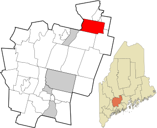
Benton is a town in Kennebec County, Maine, United States. It was formed in 1842, as a subdivision of the town of Clinton. The population was 2,715 at the 2020 census. The town was named for Missouri Senator Thomas Hart Benton.

Stoneham is a town in Oxford County, Maine, United States. The population was 261 at the 2020 census.

<span class="mw-page-title-main">Upton, Maine</span> Town in the state of Maine, United States

Upton is a town in Oxford County, Maine, United States. The population was 69 at the 2020 census.

<span class="mw-page-title-main">Machiasport, Maine</span> Town in the state of Maine, United States

Machiasport is a town in Washington County, Maine, United States. The population was 962 at the 2020 census. Machiasport is a historic seaport and tourist destination.

<span class="mw-page-title-main">Bluffton, Minnesota</span> City in Minnesota, United States

Bluffton is a city in Otter Tail County, Minnesota, United States, along the Leaf River. The population was 210 at the 2020 census.

<span class="mw-page-title-main">Cedar Bluffs, Nebraska</span> Village in Saunders County, Nebraska, United States

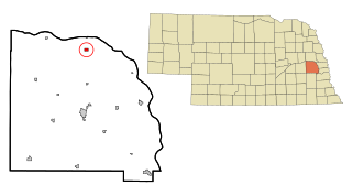
Cedar Bluffs is a village in Saunders County, Nebraska, United States. The population was 615 at the 2020 census. Cedar Bluffs was a point on the Mormon, Oregon, and California Trails.

<span class="mw-page-title-main">Morse Bluff, Nebraska</span> Village in Saunders County, Nebraska, United States

Morse Bluff is a village in Saunders County, Nebraska, United States. The population was 117 at the 2020 census.

<span class="mw-page-title-main">New Haven, New York</span> Town in New York, United States

New Haven is a town in Oswego County, New York, United States. The population was 2,856 at the 2010 census.

<span class="mw-page-title-main">Lago, Texas</span> Census-designated place in Texas, United States

Lago is a census-designated place (CDP) in Cameron County, Texas, United States. The population was 204 at the 2010 census. It is part of the Brownsville–Harlingen Metropolitan Statistical Area.

<span class="mw-page-title-main">Chester, West Virginia</span> City in West Virginia, United States

Chester is a city in northern Hancock County, West Virginia, United States, along the Ohio River. The population was 2,214 at the 2020 census. Located immediately south of Ohio and just west of Pennsylvania, Chester is the northernmost city in West Virginia. It is a part of the Weirton–Steubenville metropolitan area, and is home to the World's Largest Teapot.

<span class="mw-page-title-main">Maple Bluff, Wisconsin</span> Village in Wisconsin, United States

Maple Bluff is a village in Dane County, Wisconsin, United States. The population was 1,313 at the 2010 census. A suburb of Madison, it is part of the Madison Metropolitan Statistical Area.

<span class="mw-page-title-main">Pine Bluffs, Wyoming</span> Town in Wyoming, United States

Pine Bluffs is a town in eastern Laramie County, Wyoming, United States. It is located on the county's border with Nebraska. Pine Bluffs is part of the Cheyenne, Wyoming, Metropolitan Statistical Area. The population was 1,129 at the 2010 census. It was first known as Rock Ranch, but the name was changed by railroad officials for the pines on the nearby bluffs.

<span class="mw-page-title-main">North Crows Nest, Indiana</span> Town in Indiana, United States

North Crows Nest is a town in Washington Township, Marion County, Indiana, United States. It is approximately 7 miles (11 km) north of downtown Indianapolis. The population was 44 at the 2020 census. It has existed as an "included town" since 1970, when it was incorporated into Indianapolis as part of Unigov. It is part of Indianapolis, but retains town governmental powers under IC 36-3-1-11.

<span class="mw-page-title-main">Spring Hill, Indiana</span> Town in Indiana, United States

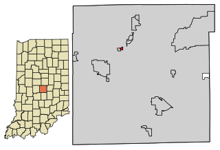
Spring Hill is a town in Marion County, Indiana, United States. The population was 95 at the 2020 census. It has existed as an "included town" since 1970, when it was incorporated into Indianapolis as part of Unigov. It is part of Indianapolis, but retains town governmental powers under IC 36-3-1-11.

Sullivan is a town in Jefferson County, Wisconsin, United States. The population was 2,208 at the 2010 census. The village of Sullivan, the census-designated place of Rome, and the unincorporated communities of Heath Mills, Oak Hill, and Slabtown are located in the town.

References

  1. 1 2 "US Gazetteer files 2010". United States Census Bureau . Retrieved December 16, 2012.
  2. "Census - Geography Profile: Roque Bluffs town, Washington County, Maine". United States Census Bureau . Retrieved March 12, 2022.
  3. "Census of Population and Housing". Census.gov. Retrieved June 4, 2015.
  4. "U.S. Census website". United States Census Bureau . Retrieved December 16, 2012.
  5. "U.S. Census website". United States Census Bureau . Retrieved January 31, 2008.

44°36′46″N67°28′47″W / 44.61278°N 67.47972°W / 44.61278; -67.47972