Woodland, Washington County, Maine

Last updated

Woodland, Maine
USA Maine location map.svg
Red pog.svg
Woodland, Maine
Location within the state of Maine
Coordinates: 45°9′18″N67°24′25″W / 45.15500°N 67.40694°W / 45.15500; -67.40694
Country United States
State Maine
County Washington
Area
  Total1.5 sq mi (4 km2)
  Land1.1 sq mi (3 km2)
  Water0.3 sq mi (0.8 km2)
Population
 (2010)
  Total952
  Density630/sq mi (250/km2)
Time zone UTC-5 (Eastern (EST))
  Summer (DST) UTC-4 (EDT)

Woodland is a census-designated place (CDP) in the town of Baileyville, Washington County, Maine, United States. The population was 952 at the 2010 census. [1]

Contents

"Woodland" was originally the name of the entire town of Baileyville. However, because the state of Maine has a law stating that no two towns within it may share the same name, Woodland of Aroostook County and Woodland of Washington County found themselves before the Maine Supreme Judicial Court in the late 1990s. Because it was founded as a township first, the Woodland of Aroostook County was allowed to keep its name, and Woodland of Washington County was ordered by the court to choose a new name: "Baileyville".

Geography

Baileyville is located at 45°9′18″N67°24′25″W / 45.15500°N 67.40694°W / 45.15500; -67.40694 (45.155103, -67.406968). [2]

According to the United States Census Bureau, the CDP has a total area of 1.5 square miles (3.8 km2), of which 1.1 square miles (3.0 km2) is land and 0.3 square miles (0.8 km2), or 20.69%, is water.

History

Water powered sawmills and paper mills at Woodland used wooden logs and pulpwood floated down the Saint Croix River. These mills were connected to the national rail network via the Maine Central Railroad and under Georgia-Pacific operation [3] originated or terminated over 6,000 railway carloads in 1973. [4]

In 1950, the village voted to stay on Daylight saving time, so as to allow hunters an extra hour of daylight after work, as they would otherwise be hunting at night. It was known locally as "Deerlight Saving Time" and overlapped with the start of deer season, through November 1. [5]

Demographics

As of the census [6] of 2000, there were 1,044 people, 455 households, and 293 families residing in the CDP. The population density was 906.7 inhabitants per square mile (350.1/km2). There were 553 housing units at an average density of 480.3 per square mile (185.4/km2). The racial makeup of the CDP was 98.66% White, 0.10% African American, 0.10% Native American, 0.19% Asian, 0.10% from other races, and 0.86% from two or more races. Hispanic or Latino of any race were 0.10% of the population.

There were 455 households, out of which 28.1% had children under the age of 18 living with them, 50.5% were married couples living together, 10.1% had a female householder with no husband present, and 35.4% were non-families. 30.3% of all households were made up of individuals, and 14.7% had someone living alone who was 65 years of age or older. The average household size was 2.29 and the average family size was 2.83.

In the CDP, the population was spread out, with 23.9% under the age of 18, 6.2% from 18 to 24, 26.4% from 25 to 44, 25.4% from 45 to 64, and 18.0% who were 65 years of age or older. The median age was 41 years. For every 100 females, there were 93.0 males. For every 100 females age 18 and over, there were 89.5 males.

The median income for a household in the CDP was $32,179, and the median income for a family was $38,571. Males had a median income of $38,750 versus $21,354 for females. The per capita income for the CDP was $17,220. About 8.0% of families and 9.5% of the population were below the poverty line, including 13.5% of those under age 18 and 8.2% of those age 65 or over.

Related Research Articles

<span class="mw-page-title-main">Washington County, Maine</span> County in Maine, United States

Washington County is a county located in the U.S. state of Maine. As of the 2010 census, its population was 31,095, making it the third-least populous county in Maine. Its county seat is Machias. The county was established on June 25, 1789. It borders the Canadian province of New Brunswick.

<span class="mw-page-title-main">Aroostook County, Maine</span> County in Maine, United States

Aroostook County is a county in the U.S. state of Maine along the Canada–U.S. border. As of the 2020 census, the population was 67,105. Its county seat is Houlton, with offices in Caribou and Fort Kent.

<span class="mw-page-title-main">Blaine, Maine</span> Town in the state of Maine, United States

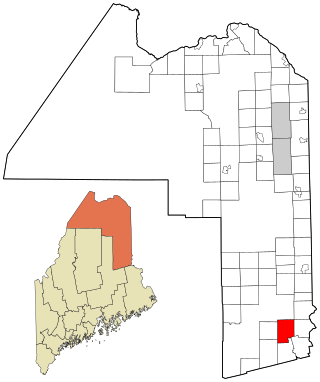
Blaine is a town in Aroostook County, Maine, United States. The population was 667 at the 2020 census. It was known as Alva prior to incorporation in 1874, when it was renamed in honor of James G. Blaine, then Speaker of the U.S. House of Representatives. According to local history, Blaine offered to donate a large bell for the tower of the town's new meeting hall, if the citizens would rename the town after him. The town's name was changed, but Blaine never donated a bell. The building still stands on the north end of town, on Route 1.

<span class="mw-page-title-main">Garfield Plantation, Maine</span> Plantation in Maine, United States

Garfield Plantation is a plantation in Aroostook County, Maine, United States. The population was 79 at the 2020 census.

<span class="mw-page-title-main">Haynesville, Maine</span> Town in the state of Maine, United States

Haynesville is a town in Aroostook County, Maine, United States. The population was 97 at the 2020 census.

<span class="mw-page-title-main">Linneus, Maine</span> Town in the state of Maine, United States

Linneus is a town in Aroostook County, Maine, United States. The population was 947 at the 2020 census. It is named after Carl Linnaeus.

<span class="mw-page-title-main">Littleton, Maine</span> Town in the state of Maine, United States

Littleton is a town in Aroostook County, Maine, United States. The population was 997 at the 2020 census.

Mars Hill-Blaine was a census-designated place (CDP) occupying parts of the towns of Mars Hill and Blaine in Aroostook County, Maine, United States. The population was 1,428 at the 2000 census. For the 2010 census the area was redelineated as two separate CDPs, Mars Hill and Blaine.

<span class="mw-page-title-main">Orient, Maine</span> Town in the state of Maine, United States

Orient is a town in Aroostook County, Maine, United States. The population was 156 at the 2020 census.

<span class="mw-page-title-main">Westfield, Maine</span> Town in the state of Maine, United States

Westfield is a town in Aroostook County, Maine, United States. The population was 455 at the 2020 census.

Baileyville is a town in Washington County, Maine, United States. The population was 1,318 at the 2020 census. Within the town is the census-designated place of Woodland. The town was originally settled by Quakers in 1780. In 1830, Ezekiel Bailey began the commercial manufacture of oilcloth. The business flourished and expanded until it comprised several factories, which burned down in 1921.

<span class="mw-page-title-main">North Marysville, Washington</span> CDP in Washington, United States

North Marysville is a census-designated place (CDP) in Snohomish County, Washington, United States. The majority of the community and its 20,000 residents were annexed into the city of Marysville in 2009. The population was 108 at the 2010 census.

<span class="mw-page-title-main">Van Buren (CDP), Maine</span> Census-designated place in Maine, United States

Van Buren is a census-designated place (CDP) comprising the main village within the town of Van Buren in Aroostook County, Maine, United States. The population of the CDP was 1,937 at the 2010 census, out of a population of 2,171 for the entire town.

<span class="mw-page-title-main">Houlton (CDP), Maine</span> Census-designated place in Maine, United States

Houlton is a census-designated place (CDP) comprising the main village within the town of Houlton in Aroostook County, Maine, United States. The population of the CDP was 4,856 at the 2010 census, out of a population of 6,123 for the entire town. Houlton is the county seat of Aroostook County. The northern terminus of Interstate 95 and eastern terminus of U.S. Route 2 are just east of the CDP at the Canada–United States border.

<span class="mw-page-title-main">Woodland, Aroostook County, Maine</span> Town in the state of Maine, United States

Woodland is a town in Aroostook County, Maine, United States. The population was 1,217 at the 2020 census. Because the state of Maine has a law stating that no two towns may share the same name, Woodland of Aroostook County and Woodland of Washington County found themselves before the Maine Supreme Judicial Court in the late 1990s. Because it was founded as a township first, Woodland of Aroostook County was allowed to keep its name and Woodland of Washington County was ordered by the court to choose a new name: Baileyville.

<span class="mw-page-title-main">Fort Fairfield (CDP), Maine</span> Census-designated place in Maine, United States

Fort Fairfield is a census-designated place (CDP) comprising the main village within the town of Fort Fairfield in Aroostook County, Maine, United States. The population of the CDP was 1,825 at the 2010 census, out of a population of 3,496 for the entire town.

<span class="mw-page-title-main">Fort Fairfield, Maine</span> Town in the state of Maine, United States

Fort Fairfield is a town in Aroostook County, eastern Maine, United States, located along the Canada–US border. The population was 3,322 at the 2020 census.

<span class="mw-page-title-main">Fort Kent (CDP), Maine</span> Census-designated place in Maine, United States

Fort Kent is a census-designated place (CDP) that comprises the main village in the town of Fort Kent in Aroostook County, Maine, United States. In 2010, Fort Kent's population was 2,488 of 4,097 for the entire town.

<span class="mw-page-title-main">Limestone (CDP), Maine</span> Census-designated place in Maine, United States

Limestone is a census-designated place (CDP) comprising the main village within the town of Limestone in Aroostook County, Maine, United States. The population was 1,075 at the 2010 census, out of a population of 2,314 for the entire town.

<span class="mw-page-title-main">Madawaska (CDP), Maine</span> Census-designated place in Maine, United States

Madawaska is a census-designated place (CDP) comprising the main village within the town of Madawaska in Aroostook County, Maine, United States. The population of the CDP was 2,967 at the 2010 census, out of a population of 4,035 for the entire town.

References

  1. "Profile of General Population and Housing Characteristics: 2010 Demographic Profile Data (DP-1): Woodland CDP, Maine". United States Census Bureau . Retrieved July 20, 2012.
  2. "US Gazetteer files: 2010, 2000, and 1990". United States Census Bureau. February 12, 2011. Retrieved April 23, 2011.
  3. 470 Railroad Club (1981). Meet the Maine Central. KJ Printing. p. 63.
  4. United States Department of Transportation (1974). Rail Service in the Midwest and Northeast Region. United States Government Printing Office.
  5. "It's Deerlight Saving Time" . The Moncton Daily Times. November 3, 1950. p. 3.
  6. "U.S. Census website". United States Census Bureau . Retrieved January 31, 2008.