Machiasport, Maine

Last updated

Machiasport, Maine
View of Machiasport, ME.jpg
Machiasport c.1908
USA Maine location map.svg
Red pog.svg
Machiasport, Maine
Location within the state of Maine
Coordinates: 44°39′42″N67°22′55″W / 44.66167°N 67.38194°W / 44.66167; -67.38194
Country United States
State Maine
County Washington
Incorporated1826
Area
[1]
  Total61.61 sq mi (159.57 km2)
  Land21.41 sq mi (55.45 km2)
  Water40.20 sq mi (104.12 km2)
Elevation
0 ft (0 m)
Population
 (2020)
  Total962
  Density45/sq mi (17.3/km2)
Time zone UTC-5 (Eastern (EST))
  Summer (DST) UTC-4 (EDT)
ZIP code
04655
Area code 207
FIPS code 23-42100
GNIS feature ID0582574

Machiasport is a town in Washington County, Maine, United States. The population was 962 at the 2020 census. [2] Machiasport is a historic seaport and tourist destination.

Contents

History

In 1633, the Plymouth Company established a trading post here to conduct business with the Native Americans. But this was part of Acadia, territory which New France considered its own. So in 1634, the trading post was sacked by French forces from Port Royal under the command of Charles de Saint-Étienne de la Tour. [3] In 1770, the area was granted by the Massachusetts General Court to 80 petitioners, 54 from Scarborough. It was first part of Machias, incorporated in 1784, then set off and incorporated as Machiasport in 1826. [4]

In 1775, following the capture of the British ship HMS Margaretta by locals under leadership of Jeremiah O'Brien, the residents built a small breastworks here to guard the mouth of the Machias River and the area settlements. Later that year, the British sent four ships under the command of Sir George Collier that defeated the local militia, destroyed the breastworks, and burned several buildings. In 1777, the fort was rebuilt as a crescent shaped four-gun battery. In 1781 it was made part of the national defense and named Fort O'Brien. In 1808–1809, Lemuel Trescott of Eastport oversaw the construction of a blockhouse, barracks and battery. During the War of 1812, in September 1814 the British captured the fort and burnt the barracks. [5]

In 1863, during the American Civil War, Fort Machias was built adjacent to the ruins of Fort O'Brien. It was a five-gun earthworks fort with Napoleon 12-pound cannon. It was actively manned from 1863 to 1865. In 1923, the U.S. government transferred the sites of both forts to the state of Maine. As of 2006, they are managed as a historic site by the Maine Bureau of Parks and Lands. [6] In 1969, they were added to the National Register of Historic Places, as structure #69000024. [7]

Machiasport has been the setting of several ethnographic documentary films about its inhabitants by the anthropologist and filmmaker Anna Grimshaw. [8] [9]

Geography

According to the United States Census Bureau, the town has a total area of 61.61 square miles (159.57 km2), of which 21.41 square miles (55.45 km2) is land and 40.20 square miles (104.12 km2) is water. [1] Drained by the Machias River, the town is located at the head of Machias Bay on the Gulf of Maine, part of the Atlantic Ocean.

The town is crossed by state routes 92 and 191. It is bordered by the towns of East Machias to the north, Whiting to the northeast, Machias to the west, and (separated by water) is near Cutler to the east, and Roque Bluffs to the southwest.

Demographics

Historical population
CensusPop.Note
1830 688
1840 83421.2%
1850 1,26651.8%
1860 1,50218.6%
1870 1,5261.6%
1880 1,5310.3%
1890 1,437−6.1%
1900 1,218−15.2%
1910 1,2180.0%
1920 1,117−8.3%
1930 851−23.8%
1940 818−3.9%
1950 781−4.5%
1960 98025.5%
1970 887−9.5%
1980 1,10824.9%
1990 1,1665.2%
2000 1,160−0.5%
2010 1,119−3.5%
2020 962−14.0%
U.S. Decennial Census [10]

2010 census

As of the census [11] of 2010, there were 1,119 people, 410 households, and 277 families residing in the town. The population density was 52.3 inhabitants per square mile (20.2/km2). There were 611 housing units at an average density of 28.5 per square mile (11.0/km2). The racial makeup of the town was 97.1% White, 0.8% African American, 0.8% Native American, 0.3% Asian, 0.1% Pacific Islander, 0.3% from other races, and 0.6% from two or more races. Hispanic or Latino of any race were 1.8% of the population.

There were 410 households, of which 27.3% had children under the age of 18 living with them, 54.4% were married couples living together, 9.5% had a female householder with no husband present, 3.7% had a male householder with no wife present, and 32.4% were non-families. 26.3% of all households were made up of individuals, and 12.4% had someone living alone who was 65 years of age or older. The average household size was 2.36 and the average family size was 2.78.

The median age in the town was 43.3 years. 17.7% of residents were under the age of 18; 6% were between the ages of 18 and 24; 27.9% were from 25 to 44; 30.5% were from 45 to 64; and 18.1% were 65 years of age or older. The gender makeup of the town was 56.3% male and 43.7% female.

2000 census

As of the census [12] of 2000, there were 1,160 people, 413 households, and 289 families residing in the town. The population density was 54.3 inhabitants per square mile (21.0/km2). There were 576 housing units at an average density of 27.0 per square mile (10.4/km2). The racial makeup of the town was 97.50% White, 0.09% African American, 0.78% Native American, 0.26% Asian, and 1.38% from two or more races. Hispanic or Latino of any race were 0.26% of the population.

There were 413 households, out of which 29.1% had children under the age of 18 living with them, 58.4% were married couples living together, 7.3% had a female householder with no husband present, and 30.0% were non-families. 22.5% of all households were made up of individuals, and 8.7% had someone living alone who was 65 years of age or older. The average household size was 2.46 and the average family size was 2.88.

In the town, the population was spread out, with 20.9% under the age of 18, 8.3% from 18 to 24, 32.1% from 25 to 44, 24.8% from 45 to 64, and 14.0% who were 65 years of age or older. The median age was 38 years. For every 100 females, there were 125.7 males. For every 100 females age 18 and over, there were 134.2 males.

The median income for a household in the town was $29,531, and the median income for a family was $32,279. Males had a median income of $29,643 versus $20,500 for females. The per capita income for the town was $13,727. About 11.8% of families and 12.2% of the population were below the poverty line, including 12.9% of those under age 18 and 15.3% of those age 65 or over.

Sites of interest

Notable people

Related Research Articles

<span class="mw-page-title-main">Washington County, Maine</span> County in Maine, United States

Washington County is a county located in the U.S. state of Maine. As of the 2020 census, its population was 31,095, making it the third-least populous county in Maine. Its county seat is Machias. The county was established on June 25, 1789. It borders the Canadian province of New Brunswick.

<span class="mw-page-title-main">Monticello, Maine</span> Town in the state of Maine, United States

Monticello is a town in Aroostook County, Maine, United States on the northern branch of the Meduxnekeag River. The population was 737 at the 2020 census. Originally known as Wellington Township, it was settled in 1830 by General Joel Wellington, who owned it, and incorporated in 1846. Some of the earlier migrant workers of Monticello were called the “Amerisee”—a currently disbanded tribe whose members consisted of tribal people from all five Wabanaki Maine tribes, who traveled together as migrant seasonal workers. Many of them had settled in the Monticello and other Aroostook County areas. The word “Amerisee” comes from the Mi’kmaq word “Amase’jijg” which means “some distance” or “quite far” in reference to the distance they traveled for work, which often included all areas of Canada and Aroostook County Maine. The Matthew(s) family shows up in the 1900 Census for Monticello Maine. They had intended to form a sixth tribe—one that accepted members from all five tribes who were originally one tribe, but due to colonization, it had been split up into the five groups known today. The Amerisee wished to reunite the five tribes. The attempt ultimately failed and the Amerisee tribal members, were reabsorbed into their tribes of origin. John Matthew, who is listed on the 1900 Census in Monticello Maine along with his family, writes that he is “Amerisee” however under “Tribe of Father of this Indian” and “Tribe of Mother of this Indian” he says they were both “mi’kmaw” which is the Mi’kmaq word for “Mi’kmaq”. His children were listed as Frank, Lizzie and Annie (Anastasia) Matthew. His parents were Frank and Bertha Matthew(s). He was also a basket maker. According to his death record, he was born in “Restigouche Ind.” territory, which is a testament to how far they would travel to reach farmland in places such as Monticello. John Matthew and other families like his, make up an interesting Native American element to Monticello’s migrant seasonal and farm work history. International shortwave broadcast station WBCQ is located here.

<span class="mw-page-title-main">Weld, Maine</span> Town in the state of Maine, United States

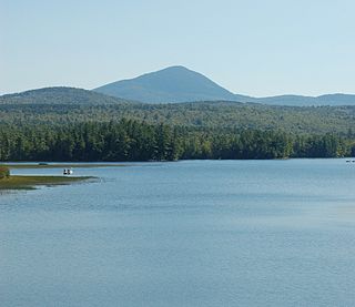
Weld is a town in Franklin County, Maine, United States. The population was 376 at the 2020 census. Set beside Webb Lake and almost surrounded by mountains, Weld is noted for its scenery. It is home to Mount Blue State Park, Camp Kawanhee for Boys, and Camp Lawroweld.

<span class="mw-page-title-main">Sedgwick, Maine</span> Town in the state of Maine, United States

Sedgwick is a town in Hancock County, Maine, United States. The population was 1,202 at the 2020 census. The town includes the village of Sargentville.

<span class="mw-page-title-main">Monmouth, Maine</span> Town in the state of Maine, United States

Monmouth is a town in Kennebec County, Maine, United States. Monmouth is included in the Lewiston-Auburn, Maine metropolitan New England city and town area. The population was 4,066 at the 2022 census.

<span class="mw-page-title-main">Rome, Maine</span> Town in the state of Maine, United States

Rome is a town in Kennebec County, Maine, United States. The population was 1,148 at the 2020 census. It is part of the Belgrade Lakes resort area, and is included in the Augusta, Maine, micropolitan New England City and Town Area.

<span class="mw-page-title-main">Dresden, Maine</span> Town in the state of Maine, United States

Dresden is a town in Lincoln County, Maine, United States, that was incorporated in 1794. The population was 1,725 at the 2020 census.

<span class="mw-page-title-main">Southport, Maine</span> Town in the state of Maine, United States

Southport is a town and archipelago in Lincoln County, Maine, United States. The population was 622 at the 2020 census. It includes the neighborhoods of Capitol Island, Cozy Harbor, East Side, Newagen, Pine Cliff, and West Southport, and the village of Squirrel Island. The majority of the town's residents live on its main island, Southport Island.

<span class="mw-page-title-main">Canton, Maine</span> Town in the state of Maine, United States

Canton is a town in Oxford County, Maine, United States. Canton is included in the Lewiston-Auburn, Maine metropolitan New England city and town area. The population was 1,125 at the 2020 census. Located beside Lake Anasagunticook, Canton is a summer recreational area.

Otisfield is a town in Oxford County, Maine, United States. Otisfield is included in the Lewiston-Auburn, Maine metropolitan New England city and town area. The population was 1,853 at the 2020 census. Otisfield is a summer recreation area and home to Seeds of Peace Camp and Camp Arcadia.

Sweden is a town in Oxford County, Maine, United States. The population was 406 at the 2020 census. Set among hills, forests and ponds, Sweden includes the village of East Sweden.

Eddington is a town located on the eastern side of the Penobscot River in Penobscot County, Maine, United States. As of the 2020 census, the town had a population of 2,194.

<span class="mw-page-title-main">Bowdoin, Maine</span> Town in the state of Maine, United States

Bowdoin is a town in Sagadahoc County, Maine, United States. Bowdoin is included in the Lewiston-Auburn, Maine metropolitan New England city and town area. The population was 3,136 at the 2020 census. Bowdoin is 31 land miles north of Portland, and 21 land miles south of Augusta.

<span class="mw-page-title-main">Prospect, Maine</span> Town in the state of Maine, United States

Prospect is a town in Waldo County, Maine, United States. The population was 698 at the 2020 census.

<span class="mw-page-title-main">Stockton Springs, Maine</span> Town in the state of Maine, United States

Stockton Springs is a town in Waldo County, Maine, United States. The population was 1,533 at the 2020 census. Stockton Springs is home to Fort Point State Park and Fort Point Light, both located on Fort Point, a peninsula on Cape Jellison.

<span class="mw-page-title-main">East Machias, Maine</span> Town in Maine, United States

East Machias is a town in Washington County, Maine, United States on the East Machias River. At the 2020 census, the town population was 1,326. It is the home of Washington Academy, a private school founded in 1792.

Jonesboro is a town in Washington County, Maine, United States. The town was named for John Coffin Jones, a landholder. The population was 587 at the 2020 census.

<span class="mw-page-title-main">Shapleigh, Maine</span> Town in the state of Maine, United States

Shapleigh, pronounced "SHAP-lee", is a town in York County, Maine, United States which was incorporated as the state's 43rd town in 1785. The population was 2,921 at the 2020 census. Shapleigh is divided into the villages of North Shapleigh, Shapleigh Corner, Ross Corner and Emery Mills. It is part of the Portland–South Portland–Biddeford, Maine metropolitan statistical area.

<span class="mw-page-title-main">Machias, New York</span> Town in New York, United States

Machias is a town in Cattaraugus County, New York, United States. The population was 2,309 at the 2020 census. Machias is an interior town in the northeast quadrant of the county. It is northeast of the city of Salamanca.

Machias is a town in and the county seat of Washington County in Down East Maine, United States. As of the 2020 census, the town population was 2,060. It is home to the University of Maine at Machias and Machias Valley Airport, a small public airport owned by the town. The word Machias roughly translates in Passamaquoddy as "bad little falls", a reference to the Machias River. Machias was the site of the first naval battle of the American Revolution.

References

  1. 1 2 "US Gazetteer files 2010". United States Census Bureau . Retrieved December 16, 2012.
  2. "Census - Geography Profile: Machiasport town, Washington County, Maine". United States Census Bureau . Retrieved January 21, 2022.
  3. Coolidge, Austin J.; John B. Mansfield (1859). A History and Description of New England. Boston, Massachusetts: A.J. Coolidge. p.  204. coolidge mansfield history description new england 1859.
  4. Varney, George J. (1886), Gazetteer of the state of Maine. Machiasport, Boston: Russell
  5. Maine League of Historical Societies and Museums (1970). Doris A. Isaacson (ed.). Maine: A Guide 'Down East'. Rockland, Me: Courier-Gazette, Inc. pp. 271–272.
  6. "Historic Fort O'Brien". Maine Bureau of Parks and Lands. October 27, 2006. Retrieved December 10, 2006.
  7. "MAINE - Washington County". www.nationalregisterofhistoricalplaces.com. January 26, 2006. Retrieved December 10, 2006.
  8. Grimshaw, Anna (2016). "At Low Tide". Royal Anthropological Institute.
  9. Ramey, Kathryn (November 30, 2015). "Time and the Axe: A Review of Anna Grimshaw's Mr. Coperthwaite". Society for Cultural Anthropology. Retrieved June 15, 2023.
  10. "Census of Population and Housing". Census.gov. Retrieved June 4, 2015.
  11. "U.S. Census website". United States Census Bureau . Retrieved December 16, 2012.
  12. "U.S. Census website". United States Census Bureau . Retrieved January 31, 2008.

44°41′55″N67°23′41″W / 44.69861°N 67.39472°W / 44.69861; -67.39472