Dennysville, Maine

Last updated

Dennysville, Maine
Dennysville Historic District, Maine 2012.jpg
Dennysville Historic District, Dennysville
USA Maine location map.svg
Red pog.svg
Dennysville, Maine
Location within the state of Maine
Coordinates: 44°55′30″N67°13′57″W / 44.92500°N 67.23250°W / 44.92500; -67.23250
Country United States
State Maine
County Washington
Area
[1]
  Total15.28 sq mi (39.58 km2)
  Land14.92 sq mi (38.64 km2)
  Water0.36 sq mi (0.93 km2)
Elevation
177 ft (54 m)
Population
 (2020)
  Total300
  Density20/sq mi (7.8/km2)
Time zone UTC-5 (Eastern (EST))
  Summer (DST) UTC-4 (EDT)
ZIP code
04628
Area code 207
FIPS code 23-17355
GNIS feature ID0582440

Dennysville is a town in Washington County, Maine, United States. The population was 300 at the 2020 census. [2]

Contents

History

Dennysville takes its name from the Dennys River. [3] It was first settled by a group of sixteen men who came by boat from Hingham, Massachusetts. They arrived on the river shore on May 17, 1786. [4]

Geography

According to the United States Census Bureau, the town has a total area of 15.28 square miles (39.58 km2), of which 14.92 square miles (38.64 km2) is land and 0.36 square miles (0.93 km2) is water. [1]

Demographics

Historical population
CensusPop.Note
1820 557
1830 85653.7%
1840 378−55.8%
1850 45821.2%
1860 4855.9%
1870 4880.6%
1880 5227.0%
1890 452−13.4%
1900 4826.6%
1910 459−4.8%
1920 434−5.4%
1930 4432.1%
1940 424−4.3%
1950 345−18.6%
1960 303−12.2%
1970 278−8.3%
1980 2966.5%
1990 35519.9%
2000 319−10.1%
2010 3427.2%
2020 300−12.3%
U.S. Decennial Census [5]

2010 census

As of the census [6] of 2010, there were 342 people, 154 households, and 96 families living in the town. The population density was 22.9 inhabitants per square mile (8.8/km2). There were 189 housing units at an average density of 12.7 per square mile (4.9/km2). The racial makeup of the town was 97.4% White, 0.6% Native American, and 2.0% from two or more races. Hispanic or Latino of any race were 1.8% of the population.

There were 154 households, of which 22.1% had children under the age of 18 living with them, 51.3% were married couples living together, 7.1% had a female householder with no husband present, 3.9% had a male householder with no wife present, and 37.7% were non-families. 33.8% of all households were made up of individuals, and 18.8% had someone living alone who was 65 years of age or older. The average household size was 2.22 and the average family size was 2.86.

The median age in the town was 48.6 years. 19.9% of residents were under the age of 18; 6.7% were between the ages of 18 and 24; 19.3% were from 25 to 44; 34.5% were from 45 to 64; and 19.6% were 65 years of age or older. The gender makeup of the town was 46.8% male and 53.2% female.

2000 census

At the 2000 census, [7] there were 319 people, 140 households and 95 families living in the town. The population density was 21.6 per square mile (8.3/km2). There were 201 housing units at an average density of 13.6 per square mile (5.3/km2). The racial makeup of the town was 99.37% White, and 0.63% from two or more races. Hispanic or Latino of any race were 0.31% of the population.

There were 140 households, of which 28.6% had children under the age of 18 living with them, 55.0% were married couples living together, 6.4% had a female householder with no husband present, and 32.1% were non-families. 30.7% of all households were made up of individuals, and 19.3% had someone living alone who was 65 years of age or older. The average household size was 2.28 and the average family size was 2.79.

24.1% of the population were under the age of 18, 7.5% from 18 to 24, 23.8% from 25 to 44, 24.1% from 45 to 64, and 20.4% who were 65 years of age or older. The median age was 41 years. For every 100 females, there were 92.2 males. For every 100 females age 18 and over, there were 90.6 males.

The median household income was $20,000 and the median family income was $28,750. Males had a median income of $27,292 versus $13,750 for females. The per capita income for the town was $13,336. About 20.8% of families and 23.6% of the population were below the poverty line, including 15.9% of those under age 18 and 29.5% of those age 65 or over.

Related Research Articles

<span class="mw-page-title-main">Crystal, Maine</span> Town in the state of Maine, United States

Crystal is a town in Aroostook County, Maine, United States. The population was 248 at the 2020 census.

<span class="mw-page-title-main">Grand Isle, Maine</span> Town in the state of Maine, United States

Grand Isle is a town in Aroostook County, Maine, United States. The population was 366 at the 2020 census. The village of Grand Isle is in the northwestern part of the town.

<span class="mw-page-title-main">Masardis, Maine</span> Town in Maine, United States

Masardis is a town in Aroostook County, Maine, United States. The population was 204 at the 2020 census.

<span class="mw-page-title-main">New Canada, Maine</span> Town in the state of Maine, United States

New Canada is a town in Aroostook County, Maine, United States. The population was 310 at the 2020 census.

<span class="mw-page-title-main">Sherman, Maine</span> Town in the state of Maine, United States

Sherman is a town in Aroostook County, Maine, United States. The population was 815 at the 2020 census.

<span class="mw-page-title-main">Stockholm, Maine</span> Town in the state of Maine, United States

Stockholm is a town in Aroostook County, Maine, United States. The population was 250 at the 2020 census.

<span class="mw-page-title-main">Wade, Maine</span> Town in the state of Maine, United States

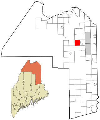
Wade is a town in Aroostook County, Maine, United States. The population was 229 at the 2020 census.

<span class="mw-page-title-main">Washburn, Maine</span> Town in the state of Maine, United States

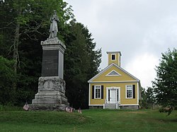
Washburn is a town in Aroostook County, Maine, United States. It was incorporated on February 25, 1861, and named after Israel Washburn, the governor of Maine at the time. The population was 1,527 at the 2020 census. Benjamin C. Wilder House, which was built in 1852, is located on Main Street in Washburn and predates the town's incorporation by nine years.

Otis is a town in Hancock County, Maine, United States. The population was 673 at the 2020 census.

<span class="mw-page-title-main">Verona Island, Maine</span> Town in Maine, United States

Verona Island is a town located on an island of the same name in the Penobscot River in Hancock County, Maine, United States. The population was 507 at the 2020 census.

<span class="mw-page-title-main">Magalloway, Maine</span> Township in Maine, United States

Magalloway is a township in Oxford County, Maine, United States. It has been part of North Oxford unorganized territory since it de-organized as a plantation in 2021. The population was 45 at the 2020 census. Part of the Umbagog National Wildlife Refuge is located at its southwestern corner.

<span class="mw-page-title-main">Upton, Maine</span> Town in the state of Maine, United States

Upton is a town in Oxford County, Maine, United States. The population was 69 at the 2020 census.

Kenduskeag is a town in Penobscot County, Maine, United States. The population was 1,346 at the 2020 census.

Springfield is a town in Penobscot County, Maine, United States. The population was 293 at the 2020 census.

<span class="mw-page-title-main">Veazie, Maine</span> Town in the state of Maine, United States

Veazie is a town in Penobscot County, Maine, United States. The population was 1,814 at the 2020 census. The town is named after General Samuel Veazie, an early lumber baron and railroad operator. Veazie was originally part of Bangor, using Penobscot River water power to operate sawmills. It became a separate town in 1853 because Gen. Veazie, its wealthiest citizen, thought Bangor's property taxes were too high.

<span class="mw-page-title-main">West Bath, Maine</span> Town in the state of Maine, United States

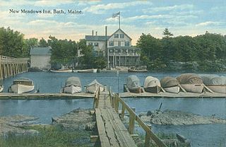
West Bath is a town in Sagadahoc County, Maine, United States. The population was 1,910 at the 2020 census. A sub-locality of West Bath is Winnegance. West Bath is part of the Portland–South Portland–Biddeford, Maine metropolitan statistical area.

<span class="mw-page-title-main">Troy, Maine</span> Town in the state of Maine, United States

Troy is a town in Waldo County, Maine, United States. The population was 1,018 at the 2020 census.

<span class="mw-page-title-main">Cherryfield, Maine</span> Town in Maine, United States

Cherryfield is a town in Washington County, Maine, United States on the Narraguagus River. It was named for the wild cherries that once peppered the banks of the river. The town population was 1,107 at the 2020 census. The town bills itself as the "Blueberry Capital of the World". Roughly 75 acres (300,000 m2) on both sides of the river are a historic district on the National Register of Historic Places known as the Cherryfield Historic District. This district comprises a collection of period structures dating from c. 1750–1890. The town was first settled about 1760. In 1826,the part of Steuben known as Narraguagus was annexed onto Cherryfield.

<span class="mw-page-title-main">Pembroke, Maine</span> Town in the state of Maine, United States

Pembroke is a town in Washington County, Maine, United States. The population was 788 at the 2020 census. The town is home to a reversing falls on Mahar's Point.

<span class="mw-page-title-main">Rib Falls, Wisconsin</span> Town in Wisconsin, United States

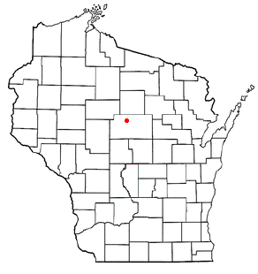
Rib Falls is a town in Marathon County, Wisconsin, United States. It is part of the Wausau, WI Metropolitan Statistical Area. The population was 993 at the 2010 census. The unincorporated community of Rib Falls is located in the town.

References

  1. 1 2 "US Gazetteer files 2010". United States Census Bureau . Retrieved December 16, 2012.
  2. "Census - Geography Profile: Dennysville town, Washington County, Maine". United States Census Bureau . Retrieved February 27, 2022.
  3. Gannett, Henry (1905). The Origin of Certain Place Names in the United States. Govt. Print. Off. pp.  104.
  4. Dennysville Centennial 1886. B. Thurston & Company, Printers , Portland, Maine. 1886. pp. 26–27.
  5. "Census of Population and Housing". Census.gov. Retrieved June 4, 2015.
  6. "U.S. Census website". United States Census Bureau . Retrieved December 16, 2012.
  7. "U.S. Census website". United States Census Bureau . Retrieved January 31, 2008.

44°54′13″N67°13′43″W / 44.90361°N 67.22861°W / 44.90361; -67.22861