
Council Bluffs is a city in and the county seat of Pottawattamie County, Iowa, United States. It is the most populous city in Southwest Iowa, as well as the third largest and a primary city of the Omaha-Council Bluffs Metropolitan Area. It is located on the east bank of the Missouri River, across from Omaha, Nebraska. Until about 1853 Council Bluffs was known as Kanesville. Kanesville was the historic starting point of the Mormon Trail. Kanesville is also the northernmost anchor town of the other emigrant trails because there was a steam-powered boat which ferried the settlers' wagons and cattle across the Missouri River. In 1869, the first transcontinental railroad to California was connected to the existing U.S. rail network at Council Bluffs.

A swing bridge is a movable bridge that has as its primary structural support a vertical locating pin and support ring, usually at or near to its center of gravity, about which the swing span can then pivot horizontally as shown in the animated illustration to the right. Small swing bridges as found over canals may be pivoted only at one end, opening as would a gate, but require substantial underground structure to support the pivot.

The Illinois Central Railroad, sometimes called the Main Line of Mid-America, was a railroad in the Central United States, with its primary routes connecting Chicago, Illinois, with New Orleans, Louisiana, and Mobile, Alabama, and thus, the Great Lakes to the Gulf of Mexico. A line also connected Chicago west to Sioux City, Iowa (1870). There was a significant branch to Omaha, Nebraska (1899), west of Fort Dodge, Iowa, and another branch reaching Sioux Falls, South Dakota (1877), starting from Cherokee, Iowa.

Gavins Point Dam is a 1.9 mi (3 km) long embankment rolled-earth and chalk-fill dam which spans the Missouri River and impounds Lewis and Clark Lake. The dam joins Cedar County, Nebraska with Yankton County, South Dakota a distance of 811.1 river miles (1,305 km) upstream of St. Louis, Missouri, where the river joins the Mississippi River. The dam and hydroelectric power plant were constructed as the Gavins Point Project from 1952 to 1957 by the United States Army Corps of Engineers as part of the Pick-Sloan Plan. The dam is located approximately 4 miles (6.4 km) west or upstream of Yankton, South Dakota.

Lewis and Clark Lake is a 31,400 acre (130 km²) reservoir located on the border of the U.S. states of Nebraska and South Dakota on the Missouri River. The lake is approximately 25 miles (40 km) in length with over 90 miles (140 km) of shoreline and a maximum water depth of 45 feet (14 m). The lake is impounded by Gavins Point Dam and is managed by the U.S. Army Corps of Engineers, Omaha District.

Interstate 680 (I-680) in Nebraska and Iowa is the northern bypass of the Omaha–Council Bluffs metropolitan area. I-680 spans 16.49 miles (26.54 km) from its southern end in western Omaha, Nebraska, to its eastern end near Crescent, Iowa. The freeway passes through a diverse range of scenes and terrains—the urban setting of Omaha, the Missouri River and its valley, the rugged Loess Hills, and the farmland of Pottawattamie County, Iowa.

The Ak-Sar-Ben Bridge was a Whipple through truss bridge that was the first road bridge to cross the Missouri River connecting Omaha, Nebraska and Council Bluffs, Iowa. It was replaced in 1966 by the Interstate 480 girder bridge.
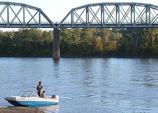
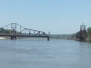
The Union Pacific Missouri River Bridge is a rail truss bridge across the Missouri River between Council Bluffs, Iowa, and Omaha, Nebraska.

The South Omaha Veterans Memorial Bridge was a continuous warren through truss bridge over the Missouri River connecting Omaha, Nebraska with Council Bluffs, Iowa via U.S. Highway 275.

Transportation in Omaha, Nebraska, includes most major modes, such as pedestrian, bicycle, automobile, bus, train and airplane. While early transportation consisted of ferries, stagecoaches, steamboats, street railroads, and railroads, the city's transportation systems have evolved to include the Interstate Highway System, parklike boulevards and a variety of bicycle and pedestrian trails. The historic head of several important emigrant trails and the First transcontinental railroad, its center as a national transportation hub earned Omaha the nickname "Gate City of the West" as early as the 1860s.
Railroads in Omaha, Nebraska, have been integral to the growth and development of the city, the state of Nebraska, the Western United States and the entire United States. The convergence of many railroad forces upon the city was by happenstance and synergy, as none of the Omaha leaders had a comprehensive strategy for bringing railroads to the city.
The Omaha and Council Bluffs Railway and Bridge Company, known as O&CB, was incorporated in 1886 in order to connect Omaha, Nebraska with Council Bluffs, Iowa over the Missouri River. With a sanctioned monopoly over streetcar service in the two cities, the O&CB was among the earliest major electric street railway systems in the nation, and was one of the last streetcar operators in the U.S., making its last run in 1955.
The Sioux City and Pacific Railroad was a railroad in the U.S. states of Iowa and Nebraska. Built as a connection from Sioux City, Iowa to the Union Pacific Railroad at Fremont, Nebraska, it became part of the Chicago and North Western Railway system in the 1880s, and is now a main line of the Union Pacific (UP). The east–west portion from Fremont to Missouri Valley, Iowa, is the Blair Subdivision, carrying mainly westbound UP trains, and the line from California Junction, Iowa north to Sioux City is the Sioux City Subdivision.

U.S. Highway 75 is a part of the United States Numbered Highway System that runs for 1,239 miles (1,994 km) from Dallas, Texas to Kittson County, Minnesota where it ends just short of the Canada–United States border. Within the State of Nebraska it is a state highway that enters Nebraska on the Kansas state line about 9 miles (14 km) south of Dawson and travels north across the extreme eastern portion of the state, to the Nebraska–Iowa border in South Sioux City where it crosses the Missouri River along a concurrency with Interstate 129. The northern 210 miles (340 km) of the route generally travels parallel to the Missouri River. The 87.32-mile (140.53 km) section between the I-680 interchange in Omaha and the Interstate 129 interchange is designated the Lewis & Clark Scenic Byway, one of nine scenic byways in the state.
Abbott Drive is a roadway mostly in Omaha, Nebraska, United States, but passes briefly through Carter Lake, Iowa. It is the easternmost link in Omaha's Park and Boulevard System that connects the eastern edge of Creighton University and North Downtown Omaha or NoDo to Carter Lake, Iowa, Eppley Airfield to John J Pershing Drive on the eastern end of Florence, Nebraska. Considered "Omaha's gateway", the drive includes a distinctive "string of pearls" lighting feature.
Gibson Bend of the Missouri River is a meander located in Pottawattamie County, Iowa and Douglas County, Nebraska, located at 41°11′15″N95°55′15″W. The Gibson neighborhood is a community area in Omaha, Nebraska abutting the Gibson Bend.

The 2011 Missouri River floods was a flooding event on the Missouri River in the United States.The flooding was triggered by record snowfall in Rocky Mountains of Montana and Wyoming along with near-record spring rainfall in central and eastern Montana. All six major dams along the Missouri River released record amounts of water to prevent overflow which led to flooding threatening several towns and cities along the river from Montana to Missouri; in particular Bismarck, North Dakota; Pierre, South Dakota; Dakota Dunes, South Dakota; South Sioux City, Nebraska, Sioux City, Iowa; Omaha, Nebraska; Council Bluffs, Iowa; Saint Joseph, Missouri; Kansas City, Missouri; Jefferson City, Missouri, and St. Louis, Missouri. Many smaller towns were also at risk, suffering the same fate as the larger cities if not worse. According to the National Weather Service, in the second half of the month of May 2011, almost a year's worth of rain fell over the upper Missouri River basin. Extremely heavy rainfall in conjunction with an estimated 212 percent of normal snowpack in the Rocky Mountains contributed to this flooding event.

U.S. Highway 136 (US 136) is a short U.S. Highway in Keokuk, Iowa. The route was designated nationally in 1951 and has remained largely unchanged through Keokuk since then. The highway originally crossed the Mississippi on the Keokuk Rail Bridge, which was the second bridge built and operated by Andrew Carnegie's Keokuk & Hamilton Bridge Company in that location. While it was designed for wagons and early automobiles, crossing the rail bridge became difficult in larger modern vehicles, specifically semi trucks. As a result, a new automobile-only bridge was built directly to the south of the older span. The Keokuk–Hamilton Bridge opened in 1985 eight months early and under budget.
U.S. Highway 75 (US 75) is a United States Highway in northwestern Iowa. It begins at the Missouri River on a bridge with Interstate 129 (I-129) and US 20. Immediately upon landing in Iowa from Nebraska, I-129 ends at an interchange with I-29. US 20 and US 75 continue around Sioux City on a four-lane expressway until US 20 exits to the east. US 75 heads to the north-northeast, parallel to the Floyd River, until Le Mars. There, Iowa Highway 60 (Iowa 60) continues northeastward on the expressway while US 75 heads due north. Near Hull, it is briefly overlapped by US 18. It leaves the state and enters Minnesota north of Rock Rapids.
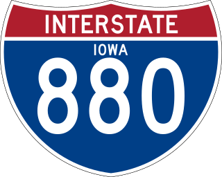
Interstate 880 (I-880) is an auxiliary Interstate Highway in Iowa. Its route was created in 2019 from a section of I-680 in order to facilitate the movement of I-29 traffic around Council Bluffs in the event of Missouri River flooding. It follows the same routing as Interstate 80N (I-80N), which originally connected I-29 and I-80 from 1966 to 1973.
