Inglis, Florida

Last updated

Inglis, Florida
Town of Inglis
Inglis Town Hall01.jpg
Inglis Town Hall
Levy County Florida Incorporated and Unincorporated areas Inglis Highlighted.svg
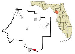
Location in Levy County and the state of Florida
Coordinates: 29°1′58″N82°40′0″W / 29.03278°N 82.66667°W / 29.03278; -82.66667
Country Flag of the United States.svg  United States
State Flag of Florida.svg  Florida
County   Levy
Incorporated 1956 [1]
Government
  Type Mayor–Commission
   Mayor Steven Schwing
   Commissioners Joyce Schwing,
Veronica Reardon,
Daniel Hill, Pat Tully,
and Isaac Young
   City Clerk Cery Logeman
   City Attorney Christopher Anderson
Area
[2]
  Total3.43 sq mi (8.89 km2)
  Land3.41 sq mi (8.84 km2)
  Water0.02 sq mi (0.04 km2)
Elevation
16 ft (5 m)
Population
 (2020)
  Total1,476
  Density432.34/sq mi (166.91/km2)
Time zone UTC-5 (Eastern (EST))
  Summer (DST) UTC-4 (EDT)
ZIP code
34449
Area code 352
FIPS code 12-33800 [3]
GNIS feature ID0294812 [4]
Website townofinglis.org

Inglis is a town in Levy County, Florida, United States. It is on U.S. Highway 19 near the Cross Florida Greenway. As of the 2020 census, the town had a population of 1,476, up from 1,325 at the 2010 census. It is part of the Gainesville, Florida Metropolitan Statistical Area.

Contents

The Town of Inglis is named after Captain John L. Inglis, who was connected with Dunnellon Phosphate. It was previously called “Port Inglis”, and the original name was “Blind Horse”. [5]

Geography

The exact coordinates for the Town of Inglis is located at 29°1′58″N82°40′0″W / 29.03278°N 82.66667°W / 29.03278; -82.66667 (29.032878, −82.666731), [6] approximately 5 miles (8 km) east of the Gulf of Mexico.

According to the United States Census Bureau, the town has a total area of 3.7 square miles (9.5 km2), of which 3.6 square miles (9.4 km2) is land and 0.015 square miles (0.04 km2), or 0.40%, is water.

Climate

The climate in this area is characterized by hot, humid summers and generally mild winters. According to the Köppen climate classification, the Town of Inglis has a humid subtropical climate zone (Cfa).

Demographics

Historical population
CensusPop.Note
1960 250
1970 44979.6%
1980 1,173161.2%
1990 1,2415.8%
2000 1,49120.1%
2010 1,325−11.1%
2020 1,47611.4%
U.S. Decennial Census [7]

2010 and 2020 census

Inglis racial composition
(Hispanics excluded from racial categories)
(NH = Non-Hispanic)
RacePop 2010 [8] Pop 2020 [9] % 2010% 2020
White (NH)1,2151,34391.70%90.99%
Black or African American (NH)6140.45%0.95%
Native American or Alaska Native (NH)470.30%0.47%
Asian (NH)1781.28%0.54%
Pacific Islander or Native Hawaiian (NH)000.00%0.00%
Some other race (NH)140.08%0.27%
Two or more races/Multiracial (NH)20501.51%3.39%
Hispanic or Latino (any race)62504.68%3.39%
Total1,3251,476100.00%100.00%

As of the 2020 United States census, there were 1,476 people, 823 households, and 456 families residing in the town. [10]

As of the 2010 United States census, there were 1,325 people, 758 households, and 448 families residing in the town. [11]

2000 census

As of the census [3] of 2000, there were 1,491 people in the town, organized into 670 households and 426 families. The population density was 408.2 inhabitants per square mile (157.6/km2). There were 803 housing units at an average density of 219.8 per square mile (84.9/km2). The racial makeup of the town was 98.73% White, 0.34% Asian, 0.13% Native American, 0.13% from other races, and 0.67% from two or more races. 1.88% of the population were Hispanic or Latino of any race.

A historical marker denotes the location of several film sites of Follow that Dream were in the vicinity of Inglis. Inglis Elvis sign01.jpg
A historical marker denotes the location of several film sites of Follow that Dream were in the vicinity of Inglis.

In 2000, there were 670 households, out of which 22.2% had children under the age of 18 living with them, 49.0% were married couples living together; 8.2% had a female householder with no husband present; and 36.3% were non-families. 31.0% of all households were made up of individuals, and 15.2% had someone living alone who was 65 years of age or older. The average household size was 2.23 and the average family size was 2.70.

In 2000, in the town, the population was spread out, with 20.9% under the age of 18, 5.0% from 18 to 24, 22.3% from 25 to 44, 29.0% from 45 to 64, and 22.8% who were 65 years of age or older. The median age was 46 years. For every 100 females, there were 97.7 males. For every 100 females age 18 and over, there were 102.7 males.

In 2000, the median income for a household in the town was $24,432, and the median income for a family was $27,734. Males had a median income of $24,342 versus $20,278 for females. The per capita income for the town was $14,098. 22.3% of the population and 18.9% of families were below the poverty line. Out of the total population, 35.1% of those under the age of 18 and 9.6% of those 65 and older were living below the poverty line.

Elvis Presley in Inglis

During July and August 1961, Elvis Presley spent his summer in Inglis and the surrounding areas filming his movie Follow That Dream . A historical marker on Follow That Dream Parkway in Inglis commemorates this event.

See also

Related Research Articles

<span class="mw-page-title-main">Penney Farms, Florida</span> Town in the state of Florida, United States

Penney Farms is a town in Clay County, Florida, United States. It is part of the Jacksonville metropolitan area. The population was 821 at the 2020 census.

<span class="mw-page-title-main">Horseshoe Beach, Florida</span> Town in the state of Florida, United States

Horseshoe Beach is a town in southern Dixie County, Florida, United States. The town is part of Big Bend and the Nature Coast in North Florida, along the Gulf of Mexico. The population was 165 at the 2020 census.

<span class="mw-page-title-main">Beverly Beach, Florida</span> Town in Florida, United States

Beverly Beach is a town in Flagler County, Florida, United States. The Town of Beverly Beach is part of the Deltona–Daytona Beach–Ormond Beach, FL metropolitan statistical area. The population was 474 at the 2020 census, up from 338 in the 2010 census.

<span class="mw-page-title-main">Fanning Springs, Florida</span> City in Florida, United States

Fanning Springs is a city in Gilchrist and Levy counties in the U.S. state of Florida. It is part of the Gainesville, Florida Metropolitan Statistical Area. The population was 1,182 at the 2020 census, up from 764 at the 2010 census.

<span class="mw-page-title-main">Orchid, Florida</span> Town in the state of Florida, United States

Orchid is a town in Indian River County, Florida, United States. The Town of Orchid is part of the Sebastian–Vero Beach Metropolitan Statistical Area. The population was 516 at the 2020 US Census, up from 415 in the 2010 US Census.

<span class="mw-page-title-main">Cottondale, Florida</span> City in Florida, United States

Cottondale is a city in Jackson County, Florida, United States. It is part of the Florida Panhandle and North Florida. The population was 848 at the 2020 census, down from 933 at the 2010 census.

<span class="mw-page-title-main">Greenwood, Florida</span> Town in Florida, United States

Greenwood is a town in Jackson County, Florida, United States. It is part of the Florida Panhandle and located in North Florida, specifically Northwest Florida. The population was 539 at the 2020 census.

<span class="mw-page-title-main">Sneads, Florida</span> Town in the state of Florida, United States

Sneads is a town in Jackson County, Florida, United States. The population was 1,849 at the 2020 census.

<span class="mw-page-title-main">Astatula, Florida</span> Town in the state of Florida, United States

Astatula is a town in Lake County, Florida, United States. The population was 1,889 at the 2020 census. It is part of the Orlando–Kissimmee–Sanford Metropolitan Statistical Area.

<span class="mw-page-title-main">Howey-in-the-Hills, Florida</span> Town in the state of Florida, United States

Howey-In-The-Hills is a town in Lake County, Florida, United States. The population was 1,643 at the 2020 census. It is part of the Orlando–Kissimmee–Sanford Metropolitan Statistical Area.

<span class="mw-page-title-main">Montverde, Florida</span> Town in Florida, United States

Montverde is a town in Lake County, Florida, United States. The population was 1,655 at the 2020 census. It is part of the Orlando–Kissimmee–Sanford Metropolitan Statistical Area.

<span class="mw-page-title-main">Bronson, Florida</span> Town in Florida, United States

Bronson is a town and the county seat of Levy County, Florida, United States. The population was 1,140 at the 2020 census, up from 1,113 at the 2010 census. It is part of the Gainesville, Florida Metropolitan Statistical Area.

<span class="mw-page-title-main">Yankeetown, Florida</span> Town in the state of Florida, United States

Yankeetown is a town in Levy County, Florida, United States. Its located in North Florida along the Gulf of Mexico. The Town of Yankeetown is part of both the Big Bend Coast and the Nature Coast. In the 2020 census, the population was 588, up from 502 at the 2010 census. It is part of the Gainesville, Florida Metropolitan Statistical Area.

<span class="mw-page-title-main">Indian Shores, Florida</span> Town in Florida, United States

Indian Shores is a town in Pinellas County, Florida, United States. It is part of the Tampa–St. Petersburg–Clearwater Metropolitan Statistical Area, more commonly known as the Tampa Bay Area. The population was 1,190 at the 2020 census.

<span class="mw-page-title-main">North Redington Beach, Florida</span> Town in the state of Florida, United States

North Redington Beach is a town in Pinellas County, Florida, United States. It is part of the Tampa–St. Petersburg–Clearwater Metropolitan Statistical Area, more commonly known as the Tampa Bay Area. The population was 1,495 at the 2020 census.

<span class="mw-page-title-main">Lake Hamilton, Florida</span> Town in the state of Florida, United States

Lake Hamilton is a town in Polk County, Florida, United States. The population was 1,537 at the 2020 census. It is part of the Lakeland–Winter Haven Metropolitan Statistical Area.

<span class="mw-page-title-main">Pomona Park, Florida</span> Town in the state of Florida, United States

Pomona Park is a town in Putnam County, Florida, United States. The Town of Pomona Park is part of the Palatka Micropolitan Statistical Area. The population was 784 at the 2020 census.

<span class="mw-page-title-main">St. Lucie Village, Florida</span> Town in the state of Florida, United States

St. Lucie Village is a town in St. Lucie County, Florida, United States. It is part of the Port St. Lucie Metropolitan Statistical Area. The population was 613 at the 2020 census.

<span class="mw-page-title-main">Paxton, Florida</span> Town in the state of Florida, United States

Paxton is a town in Walton County, Florida, United States. Located near Britton Hill on the Alabama–Florida state line, it has the highest elevation of any in Florida. The Town of Paxton is located on the Florida Panhandle, and is part of the Crestview–Fort Walton Beach–Destin, Florida Metropolitan Statistical Area. The population was 556 as of the 2020 census, down from 644 at the 2010 census.

<span class="mw-page-title-main">Indian River Shores, Florida</span> Town in the state of Florida, United States

Indian River Shores is a town in Indian River County, Florida, United States. As of the 2020 census, the town has a population of 4,241. Located on Orchid Island, Indian River Shores is bordered by the Atlantic Ocean to the east and the Indian River Lagoon to the west.

References

  1. "FLORIDA CITIES BY INCORPORATION YEAR" (PDF). Florida League of Cities.
  2. "2020 U.S. Gazetteer Files". United States Census Bureau. Retrieved October 31, 2021.
  3. 1 2 "U.S. Census website". United States Census Bureau . Retrieved January 31, 2008.
  4. "US Board on Geographic Names". United States Geological Survey. October 25, 2007. Retrieved January 31, 2008.
  5. https://www.votelevy.com/Portals/Levy/documents/Florida%20and%20The%20Birth%20of%20Levy%20County.pdf
  6. "US Gazetteer files: 2010, 2000, and 1990". United States Census Bureau. February 12, 2011. Retrieved April 23, 2011.
  7. "Census of Population and Housing". Census.gov. Retrieved June 4, 2015.
  8. "P2 HISPANIC OR LATINO, AND NOT HISPANIC OR LATINO BY RACE - 2010: DEC Redistricting Data (PL 94-171) - Inglis town, Florida". United States Census Bureau .
  9. "P2 HISPANIC OR LATINO, AND NOT HISPANIC OR LATINO BY RACE - 2020: DEC Redistricting Data (PL 94-171) - Inglis town, Florida". United States Census Bureau .
  10. "S1101 HOUSEHOLDS AND FAMILIES - 2020: Inglis town, Florida". United States Census Bureau .
  11. "S1101 HOUSEHOLDS AND FAMILIES - 2010: Inglis town, Florida". United States Census Bureau .