Inman Mills, South Carolina

Last updated
Inman Mills, South Carolina
CDP
SCMap-doton-Inman.PNG
Location of Inman Mills, South Carolina
Coordinates: 35°2′28″N82°5′58″W / 35.04111°N 82.09944°W / 35.04111; -82.09944
Country United States
State South Carolina
County Spartanburg
Area
[1]
  Total1.08 sq mi (2.80 km2)
  Land1.08 sq mi (2.80 km2)
  Water0.00 sq mi (0.00 km2)
Elevation
[2]
919 ft (280 m)
Population
 (2020) [3]
  Total1,233
  Density1,142.72/sq mi (441.02/km2)
Time zone UTC-5 (Eastern (EST))
  Summer (DST) UTC-4 (EDT)
ZIP code
29349 [4]
Area code 864
FIPS code 45-35800 [5]
GNIS feature ID1231419 [2]

Inman Mills is a census-designated place (CDP) in Spartanburg County, South Carolina, United States. The population was 1,050 at the 2010 census. [6]

Contents

Geography

Inman Mills is located at 35°2′28″N82°5′58″W / 35.04111°N 82.09944°W / 35.04111; -82.09944 (35.041210, -82.099394). [7] It lies adjacent to the incorporated city of Inman.

According to the United States Census Bureau, the CDP has a total area of 1.3 square miles (3.4 km2), all land.

Demographics

Historical population
CensusPop.Note
2000 1,151
2010 1,050−8.8%
2020 1,23317.4%
U.S. Decennial Census [8]

As of the census [5] of 2000, there were 1,151 people, 435 households, and 261 families residing in the CDP. The population density was 911.5 inhabitants per square mile (351.9/km2). There were 464 housing units at an average density of 367.5 per square mile (141.9/km2). The racial makeup of the CDP was 90.88% White, 7.12% African American, 0.09% Asian, 1.13% from other races, and 0.78% from two or more races. Hispanic or Latino of any race were 2.95% of the population.

There were 435 households, out of which 21.1% had children under the age of 18 living with them, 43.9% were married couples living together, 12.9% had a female householder with no husband present, and 39.8% were non-families. 37.0% of all households were made up of individuals, and 23.4% had someone living alone who was 65 years of age or older. The average household size was 2.07 and the average family size was 2.65.

In the CDP, the population was spread out, with 13.9% under the age of 18, 6.2% from 18 to 24, 20.8% from 25 to 44, 19.3% from 45 to 64, and 39.9% who were 65 years of age or older. The median age was 54 years. For every 100 females, there were 60.8 males. For every 100 females age 18 and over, there were 57.3 males.

The median income for a household in the CDP was $26,776, and the median income for a family was $37,391. Males had a median income of $26,838 versus $19,922 for females. The per capita income for the CDP was $15,958. About 4.2% of families and 28.1% of the population were below the poverty line, including 7.0% of those under age 18 and 54.3% of those age 65 or over.

Related Research Articles

<span class="mw-page-title-main">Pisinemo, Arizona</span> CDP in Pima County, Arizona

Pisinemo is a census-designated place (CDP) in Pima County, Arizona, United States. The population was 340 as of the 2020 census.

<span class="mw-page-title-main">Reader, Arkansas</span> Census-designated place in Arkansas, United States

Reader is an unincorporated census-designated place in Nevada and Ouachita counties in the U.S. state of Arkansas. As of the 2010 census, its population is 66. Per the 2020 census, the population was 40.

<span class="mw-page-title-main">Los Molinos, California</span> Census-designated place in California, United States

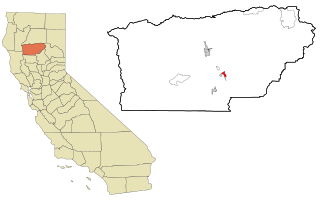
Los Molinos is a census-designated place (CDP) in Tehama County, California, United States. The population was 2,037 at the 2010 census, up from 1,952 at the 2000 census.

<span class="mw-page-title-main">Northdale, Florida</span> Census-designated place in Florida, United States

Northdale is an unincorporated census-designated place in Hillsborough County, Florida, United States. Northdale was named by the combination of the words in North Dale Mabry, the main highway through the Northdale area. The population was 22,079 at the 2010 census.

<span class="mw-page-title-main">Royal Pines, North Carolina</span> Census-designated place in North Carolina, United States

Royal Pines is a census-designated place (CDP) in Buncombe County, North Carolina, United States. The population was 4,272 at the 2010 census. It is part of the Asheville Metropolitan Statistical Area.

<span class="mw-page-title-main">East Flat Rock, North Carolina</span> Census-designated place in North Carolina, United States

East Flat Rock is an unincorporated area and census-designated place (CDP) in Henderson County, North Carolina, United States. The population was 4,995 at the 2010 census, up from 4,151 at the 2000 census. It is part of the Asheville Metropolitan Statistical Area.

<span class="mw-page-title-main">Etowah, North Carolina</span> Census-designated place in Henderson County, North Carolina, USA

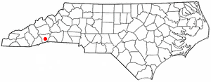
Etowah is an unincorporated community and census-designated place (CDP) in Henderson County, North Carolina, United States. The population was 6,944 at the 2010 census. It is part of the Asheville Metropolitan Statistical Area.

<span class="mw-page-title-main">Mountain Home, North Carolina</span> Census-designated place in North Carolina, United States

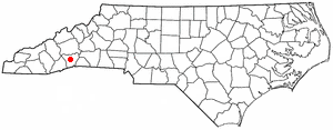
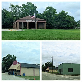
Mountain Home is an unincorporated community and census-designated place (CDP) in Henderson County, North Carolina, United States. The population was 3,622 at the 2010 census, up from 2,169 in 2000. It is part of the Asheville Metropolitan Statistical Area.

<span class="mw-page-title-main">Clearwater, South Carolina</span> Census-designated place in South Carolina, United States of America

Clearwater is a census-designated place (CDP) in Aiken County, South Carolina. It lies near North Augusta, South Carolina, and is part of the Augusta, Georgia metropolitan area. Clearwater is located in historic Horse Creek Valley. The population was 4,370 at the time of the 2010 census.

<span class="mw-page-title-main">Powdersville, South Carolina</span> Census-designated place in South Carolina, United States

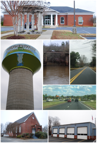
Powdersville is a census-designated place (CDP) in Anderson County, South Carolina, United States. The population was 7,618 at the 2010 census, up from 5,362 in 2000. Powdersville was initially a farming community until the increase in housing subdivisions and businesses along Highway 153.

<span class="mw-page-title-main">Winnsboro Mills, South Carolina</span> Census-designated place in South Carolina, United States

Winnsboro Mills is an unincorporated community and census-designated place (CDP) in Fairfield County, South Carolina, United States. The population was 1,898 at the 2010 census, down from 2,263 at the 2000 census. It is part of the Columbia, South Carolina Metropolitan Statistical Area.

<span class="mw-page-title-main">City View, South Carolina</span> Census-designated place in South Carolina, United States

City View, a former incorporated city, is now a census-designated place (CDP) in Greenville County, South Carolina, United States. The population was 1,345 at the 2010 census, up from 1,254 in 2000. It is part of the Greenville–Mauldin–Easley Metropolitan Statistical Area.

Duncan is a census-designated place (CDP) in Greenville County, South Carolina, United States. The population was 3,671 at the 2010 census, down from 4,158 in 2000. It is part of the Greenville–Mauldin–Easley Metropolitan Statistical Area.

<span class="mw-page-title-main">Slater-Marietta, South Carolina</span> Census-designated place in South Carolina, United States

Slater-Marietta is a census-designated place (CDP) in Greenville County, South Carolina, United States, along the North Saluda River. At the 2000 census, there were 2228 people. At the 2010 census, there were 2176. At the 2020 census, there were 1873. It is part of the Greenville–Mauldin–Easley Metropolitan Statistical Area.

<span class="mw-page-title-main">Clarks Hill, South Carolina</span> CDP in South Carolina, United States

Clarks Hill is a census-designated place (CDP) in McCormick County, South Carolina, United States. The population was 376 at the 2000 census.

<span class="mw-page-title-main">Mount Carmel, South Carolina</span> CDP in South Carolina, United States

Mt. Carmel is a census-designated place (CDP) in McCormick County, South Carolina, United States. The population was 237 at the 2000 census.

<span class="mw-page-title-main">Inman, South Carolina</span> City in South Carolina, United States

Inman is a city in Spartanburg County, South Carolina, United States. The population was 3,665 at the 2020 census, and 2,321 at the 2010 census.

<span class="mw-page-title-main">Startex, South Carolina</span> CDP in South Carolina, United States

Startex is a census-designated place (CDP) in Spartanburg County, South Carolina, United States. The population was 859 at the 2010 census. The area was originally known as Tucapau, named after the mill that was built there in 1896. In 1936, Walter Montgomery Sr. bought the mill and changed its name to Startex—the brand name of household textiles produced at the plant. The mill ceased operations in 1998 and was mostly dismantled in 1999.

<span class="mw-page-title-main">Rembert, South Carolina</span> Town in South Carolina, United States

Rembert is a town in Sumter County, South Carolina, United States. The population was 306 at the 2010 census, a decline from 406 in 2000. It is included in the Sumter, South Carolina Metropolitan Statistical Area.

<span class="mw-page-title-main">Piedmont, South Carolina</span> Census-designated place in South Carolina, United States

Piedmont is a census-designated place (CDP) along the Saluda River in Anderson and Greenville counties in the U.S. state of South Carolina. The population was 5,411 at the 2020 census.

References

  1. "ArcGIS REST Services Directory". United States Census Bureau. Retrieved October 15, 2022.
  2. 1 2 U.S. Geological Survey Geographic Names Information System: Inman Mills, South Carolina
  3. "Census Population API". United States Census Bureau. Retrieved Oct 15, 2022.
  4. "Inman Mills SC ZIP Code". zipdatamaps.com. 2023. Retrieved February 17, 2023.
  5. 1 2 "U.S. Census website". United States Census Bureau . Retrieved 2008-01-31.
  6. "Race, Hispanic or Latino, Age, and Housing Occupancy: 2010 Census Redistricting Data (Public Law 94-171) Summary File (QT-PL), Inman Mills CDP, South Carolina". United States Census Bureau . Retrieved August 16, 2011.
  7. "US Gazetteer files: 2010, 2000, and 1990". United States Census Bureau. 2011-02-12. Retrieved 2011-04-23.
  8. "Census of Population and Housing". Census.gov. Retrieved June 4, 2016.