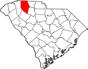
Startex, South Carolina

Last updated

Startex, South Carolina
CDP
SCMap-doton-Startex.PNG
Location of Startex, South Carolina
Coordinates: 34°55′54″N82°5′55″W / 34.93167°N 82.09861°W / 34.93167; -82.09861
Country United States
State South Carolina
County Spartanburg
Area
[1]
  Total1.12 sq mi (2.90 km2)
  Land1.11 sq mi (2.87 km2)
  Water0.01 sq mi (0.03 km2)
Elevation
[2]
794 ft (242 m)
Population
 (2020) [3]
  Total745
  Density672.99/sq mi (259.73/km2)
Time zone UTC-5 (Eastern (EST))
  Summer (DST) UTC-4 (EDT)
ZIP code
29377
Area code 864
FIPS code 45-68920 [4]
GNIS feature ID1231824 [2]

Startex is a census-designated place (CDP) in Spartanburg County, South Carolina, United States. The population was 859 at the 2010 census. [5] The area was originally known as Tucapau, named after the mill that was built there in 1896. In 1936, Walter Montgomery Sr. bought the mill and changed its name to Startex—the brand name of household textiles produced at the plant. The mill ceased operations in 1998 and was mostly dismantled in 1999. [6]

Contents

Geography

Startex is located at 34°55′54″N82°5′55″W / 34.93167°N 82.09861°W / 34.93167; -82.09861 (34.931672, -82.098691). [7]

According to the United States Census Bureau, the CDP has a total area of 1.9 square miles (4.9 km2), all land.

Demographics

Historical population
CensusPop.Note
2020 745
U.S. Decennial Census [8]

As of the census [4] of 2000, there were 988 people, 391 households, and 265 families residing in the CDP. The population density was 516.1 inhabitants per square mile (199.3/km2). There were 443 housing units at an average density of 231.4 per square mile (89.3/km2). The racial makeup of the CDP was 87.55% White, 11.54% African American, 0.40% Asian, 0.51% from other races. Hispanic or Latino of any race were 2.13% of the population.

There were 391 households, out of which 29.2% had children under the age of 18 living with them, 49.4% were married couples living together, 11.3% had a female householder with no husband present, and 32.2% were non-families. 28.4% of all households were made up of individuals, and 11.5% had someone living alone who was 65 years of age or older. The average household size was 2.53 and the average family size was 3.12.

In the CDP, the population was spread out, with 25.8% under the age of 18, 6.1% from 18 to 24, 29.6% from 25 to 44, 24.0% from 45 to 64, and 14.6% who were 65 years of age or older. The median age was 37 years. For every 100 females, there were 97.6 males. For every 100 females age 18 and over, there were 90.9 males.

The median income for a household in the CDP was $30,417, and the median income for a family was $38,036. Males had a median income of $24,821 versus $22,143 for females. The per capita income for the CDP was $12,619. About 7.5% of families and 13.8% of the population were below the poverty line, including 10.8% of those under age 18 and 20.9% of those age 65 or over.

Related Research Articles

<span class="mw-page-title-main">Vincent, California</span> Census-designated place in California, United States

Vincent is a census-designated place (CDP) in the central San Gabriel Valley, in Los Angeles County, California, United States. The city name and zipcode for addresses south of Arrow Highway is Covina and 91722, respectively, and Azusa and 91702 for addresses north of Arrow Highway. The population was 15,922 at the 2010 census, up from 15,097 at the 2000 census. Vincent is named after Vincent Avenue, which passes through the community.
<span class="mw-page-title-main">East Flat Rock, North Carolina</span> Census-designated place in North Carolina, United States

East Flat Rock is an unincorporated area and census-designated place (CDP) in Henderson County, North Carolina, United States. The population was 4,995 at the 2010 census, up from 4,151 at the 2000 census. It is part of the Asheville Metropolitan Statistical Area.
<span class="mw-page-title-main">Gayle Mill, South Carolina</span> Census-designated place in South Carolina, United States

Gayle Mill is a census-designated place (CDP) in Chester County, South Carolina, United States. The population was 913 at the 2010 census, down from 1,094 at the 2000 census.

<span class="mw-page-title-main">Berea, South Carolina</span> CDP in South Carolina, United States

Berea is a census-designated place (CDP) in Greenville County, South Carolina, United States. The population was 14,295 at the 2010 census. It is part of the Greenville–Mauldin–Easley Metropolitan Statistical Area.

<span class="mw-page-title-main">City View, South Carolina</span> Census-designated place in South Carolina, United States

City View, a former incorporated city, is now a census-designated place (CDP) in Greenville County, South Carolina, United States. The population was 1,345 at the 2010 census, up from 1,254 in 2000. It is part of the Greenville–Mauldin–Easley Metropolitan Statistical Area.

Duncan is a census-designated place (CDP) in Greenville County, South Carolina, United States. The population was 3,671 at the 2010 census, down from 4,158 in 2000. It is part of the Greenville–Mauldin–Easley Metropolitan Statistical Area.
<span class="mw-page-title-main">Gantt, South Carolina</span> Census-designated place in South Carolina, United States

Gantt is a census-designated place (CDP) in Greenville County, South Carolina, United States. The population was 14,229 at the 2010 census. It is part of the Greenville–Mauldin–Easley Metropolitan Statistical Area and a suburb of the city of Greenville.
<span class="mw-page-title-main">Taylors, South Carolina</span> CDP in South Carolina, United States

Taylors is a census-designated place (CDP) in Greenville County, South Carolina, United States. The population was 23,222 at the 2020 census. It is part of the Greenville–Mauldin–Easley Metropolitan Statistical Area.

<span class="mw-page-title-main">Watts Mills, South Carolina</span> Census-designated place in South Carolina, United States

Wattsville is an unincorporated community in Laurens County, South Carolina, United States. The town name is derived from Watts Mill, a textile mill in the center of town. The area is listed as the Wattsville census-designated place (CDP) for statistical purposes. The population of the CDP was 1,635 at the 2010 census. It is part of the Greenville–Mauldin–Easley Metropolitan Statistical Area.

<span class="mw-page-title-main">Mount Carmel, South Carolina</span> CDP in South Carolina, United States

Mt. Carmel is a census-designated place (CDP) in McCormick County, South Carolina, United States. The population was 237 at the 2000 census.
<span class="mw-page-title-main">Boiling Springs, South Carolina</span> CDP in South Carolina, United States

Boiling Springs is a census-designated place (CDP) in Spartanburg County, South Carolina, United States. The population was 8,219 at the 2010 census.

<span class="mw-page-title-main">Inman Mills, South Carolina</span> CDP in South Carolina, United States

Inman Mills is a census-designated place (CDP) in Spartanburg County, South Carolina, United States. The population was 1,050 at the 2010 census.

<span class="mw-page-title-main">Mayo, South Carolina</span> CDP in South Carolina, United States

Mayo is a census-designated place (CDP) in Spartanburg County, South Carolina, United States. The population was 1,592 at the 2010 census.

<span class="mw-page-title-main">Roebuck, South Carolina</span> CDP in South Carolina, United States

Roebuck is a census-designated place (CDP) in Spartanburg County, South Carolina, United States. The population was 2,200 at the 2010 census.
<span class="mw-page-title-main">Saxon, South Carolina</span> CDP in South Carolina, United States

Saxon is a census-designated place (CDP) in Spartanburg County, South Carolina, United States. The population was 3,424 at the 2010 census.

Southern Shops is a census-designated place (CDP) in Spartanburg County, South Carolina, United States. The population was 3,767 at the 2010 census.

<span class="mw-page-title-main">Valley Falls, South Carolina</span> CDP in South Carolina, United States

Valley Falls is a census-designated place (CDP) in Spartanburg County, South Carolina, United States. The population was 6,299 at the 2010 census.
<span class="mw-page-title-main">Wellford, South Carolina</span> City in South Carolina, United States

Wellford is a city in Spartanburg County, South Carolina, United States. The population was 3,293 at the 2020 census, up from 2,378 in 2010.
<span class="mw-page-title-main">Rembert, South Carolina</span> Town in South Carolina, United States

Rembert is a town in Sumter County, South Carolina, United States. The population was 306 at the 2010 census, a decline from 406 in 2000. It is included in the Sumter, South Carolina Metropolitan Statistical Area.

<span class="mw-page-title-main">Piedmont, South Carolina</span> CDP in South Carolina, United States

Piedmont is a census-designated place (CDP) along the Saluda River in Anderson and Greenville counties in the U.S. state of South Carolina. The population was 5,411 at the 2020 census.

References

  1. "ArcGIS REST Services Directory". United States Census Bureau. Retrieved October 15, 2022.
  2. 1 2 U.S. Geological Survey Geographic Names Information System: Startex, South Carolina
  3. "Census Population API". United States Census Bureau. Retrieved October 15, 2022.
  4. 1 2 "U.S. Census website". United States Census Bureau . Retrieved January 31, 2008.
  5. "Race, Hispanic or Latino, Age, and Housing Occupancy: 2010 Census Redistricting Data (Public Law 94-171) Summary File (QT-PL), Startex CDP, South Carolina". United States Census Bureau . Retrieved August 16, 2011.
  6. Orr, Susan (April 13, 2004). "STARTEX: Picking up pieces of history". Spartanburg Herald-Journal. Retrieved February 13, 2023.
  7. "US Gazetteer files: 2010, 2000, and 1990". United States Census Bureau. February 12, 2011. Retrieved April 23, 2011.
  8. "Census of Population and Housing". Census.gov. Retrieved June 4, 2016.