Reidville, South Carolina

Last updated

Reidville, South Carolina
SCMap-doton-Reidville.PNG
Location of Reidville, South Carolina
Coordinates: 34°51′54″N82°6′17″W / 34.86500°N 82.10472°W / 34.86500; -82.10472
Country United States
State South Carolina
County Spartanburg
Area
[1]
  Total1.78 sq mi (4.62 km2)
  Land1.76 sq mi (4.56 km2)
  Water0.02 sq mi (0.06 km2)
Elevation
820 ft (250 m)
Population
 (2020) [2]
  Total1,634
  Density927.88/sq mi (358.16/km2)
Time zone UTC-5 (Eastern (EST))
  Summer (DST) UTC-4 (EDT)
ZIP code
29375
Area code 864
FIPS code 45-59425 [3]
GNIS feature ID1231716 [4]
Website Reidville, South Carolina

Reidville is a town in Spartanburg County, South Carolina, United States. The population was 601 at the 2010 census. [5]

Contents

History

A post office has been in operation at Reidville since 1858. [6] The community was named for R. H. Reid, a local minister. [7]

Reidville Academy Faculty House was listed on the National Register of Historic Places in 1997. [8]

Geography

Reidville is located at 34°51′54″N82°6′17″W / 34.86500°N 82.10472°W / 34.86500; -82.10472 (34.865048, -82.104812). [9]

According to the United States Census Bureau, the town has a total area of 1.4 square miles (3.5 km2), all land.

Demographics

Historical population
CensusPop.Note
1880 266
1890 156−41.4%
1900 1623.8%
1910 1779.3%
1920 23130.5%
1930 208−10.0%
1940 2142.9%
1950 23610.3%
1960 2422.5%
1970 46090.1%
2000 478
2010 60125.7%
2020 1,634171.9%
U.S. Decennial Census [10] [2]

As of the census [3] of 2000, there were 478 people, 195 households, and 146 families residing in the town. The population density was 350.1 inhabitants per square mile (135.2/km2). There were 209 housing units at an average density of 153.1 per square mile (59.1/km2). The racial makeup of the town was 90.59% White, 7.95% African American, 0.63% Asian, and 0.84% from two or more races. Hispanic or Latino of any race were 1.67% of the population.

There were 195 households, out of which 30.3% had children under the age of 18 living with them, 63.1% were married couples living together, 8.7% had a female householder with no husband present, and 25.1% were non-families. 23.1% of all households were made up of individuals, and 10.3% had someone living alone who was 65 years of age or older. The average household size was 2.45 and the average family size was 2.90.

In the town, the population was spread out, with 19.9% under the age of 18, 6.7% from 18 to 24, 33.1% from 25 to 44, 25.9% from 45 to 64, and 14.4% who were 65 years of age or older. The median age was 39 years. For every 100 females, there were 100.8 males. For every 100 females age 18 and over, there were 100.5 males.

The median income for a household in the town was $39,861, and the median income for a family was $51,111. Males had a median income of $50,721 versus $21,635 for females. The per capita income for the town was $20,511. About 5.0% of families and 5.3% of the population were below the poverty line, including none of those under age 18 and 8.6% of those age 65 or over.

Related Research Articles

<span class="mw-page-title-main">Greasewood, Arizona</span> CDP in Navajo County, Arizona

Greasewood is a census-designated place (CDP) in Navajo County, Arizona, United States. The population was 547 at the 2010 census.

<span class="mw-page-title-main">Bancroft, Maine</span> Unorganized territory in Maine, United States

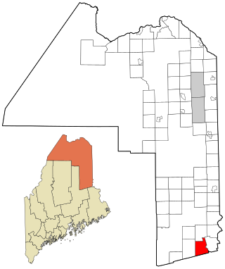
Bancroft is a township in Aroostook County, Maine, United States. The population was 57 at the 2020 census. On July 1, 2015 the town voted to deorganize and become part of the unorganized territory of South Aroostook.

<span class="mw-page-title-main">East Flat Rock, North Carolina</span> Census-designated place in North Carolina, United States

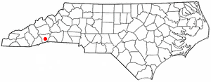
East Flat Rock is an unincorporated area and census-designated place (CDP) in Henderson County, North Carolina, United States. The population was 4,995 at the 2010 census, up from 4,151 at the 2000 census. It is part of the Asheville Metropolitan Statistical Area.

<span class="mw-page-title-main">Donalds, South Carolina</span> Town in South Carolina, United States

Donalds is a town in Abbeville County, South Carolina. As of the 2020 United States Census, its population was 328.

<span class="mw-page-title-main">Gantt, South Carolina</span> Census-designated place in South Carolina, United States

Gantt is a census-designated place (CDP) in Greenville County, South Carolina, United States. The population was 14,229 at the 2010 census. It is part of the Greenville–Mauldin–Easley Metropolitan Statistical Area and a suburb of the city of Greenville.

<span class="mw-page-title-main">Campobello, South Carolina</span> Town in South Carolina, United States

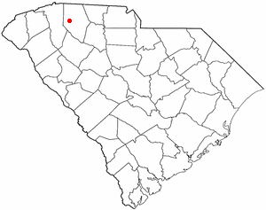
Campobello is a town in Spartanburg County, South Carolina, United States, along the South Pacolet River. The population was 502 at the 2010 census.

<span class="mw-page-title-main">Central Pacolet, South Carolina</span> Town in South Carolina, United States

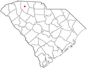
Central Pacolet is a town in Spartanburg County, South Carolina, United States, along the Pacolet River. The population was 216 at the 2010 census.

<span class="mw-page-title-main">Duncan, South Carolina</span> Town in South Carolina, United States

Duncan is a town in Spartanburg County, South Carolina, United States. Its population was 3,181 at the 2010 census.

<span class="mw-page-title-main">Inman Mills, South Carolina</span> CDP in South Carolina, United States

Inman Mills is a census-designated place (CDP) in Spartanburg County, South Carolina, United States. The population was 1,050 at the 2010 census.

<span class="mw-page-title-main">Landrum, South Carolina</span> City in South Carolina, United States

Landrum is a city in Spartanburg County, South Carolina, United States. The population was 2,376 at the 2010 census.

<span class="mw-page-title-main">Lyman, South Carolina</span> Town in South Carolina, United States

Lyman is a town in Spartanburg County, South Carolina, United States. Its population was 6,173 at the 2020 census.

<span class="mw-page-title-main">Roebuck, South Carolina</span> CDP in South Carolina, United States

Roebuck is a census-designated place (CDP) in Spartanburg County, South Carolina, United States. The population was 2,200 at the 2010 census.

<span class="mw-page-title-main">Saxon, South Carolina</span> CDP in South Carolina, United States

Saxon is a census-designated place (CDP) in Spartanburg County, South Carolina, United States. The population was 3,424 at the 2010 census.

Southern Shops is a census-designated place (CDP) in Spartanburg County, South Carolina, United States. The population was 3,663 at the 2020 census.

<span class="mw-page-title-main">Startex, South Carolina</span> CDP in South Carolina, United States

Startex is a census-designated place (CDP) in Spartanburg County, South Carolina, United States. The population was 859 at the 2010 census. The area was originally known as Tucapau, named after the mill that was built there in 1896. In 1936, Walter Montgomery Sr. bought the mill and changed its name to Startex—the brand name of household textiles produced at the plant. The mill ceased operations in 1998 and was mostly dismantled in 1999.

<span class="mw-page-title-main">Valley Falls, South Carolina</span> CDP in South Carolina, United States

Valley Falls is a census-designated place (CDP) in Spartanburg County, South Carolina, United States. The population was 6,299 at the 2010 census.

<span class="mw-page-title-main">Wellford, South Carolina</span> City in South Carolina, United States

Wellford is a city in Spartanburg County, South Carolina, United States. The population was 3,293 at the 2020 census, up from 2,378 in 2010.

<span class="mw-page-title-main">Sophia, West Virginia</span> Town in West Virginia, United States

Sophia is a town in Raleigh County, West Virginia, United States. It was incorporated in 1912. The population was 1,124 at the 2020 census.

<span class="mw-page-title-main">Bern, Wisconsin</span> Town in Wisconsin, United States

Bern is a town in Marathon County, Wisconsin, United States. It is part of the Wausau, Wisconsin Metropolitan Statistical Area. The population was 591 at the 2010 census. The unincorporated community of Gad is located partially in the town.

<span class="mw-page-title-main">Guenther, Wisconsin</span> Town in Wisconsin, United States

Guenther is a town in Marathon County, Wisconsin, United States. It is part of the Wausau, Wisconsin Metropolitan Statistical Area. The population was 341 at the 2010 census. The unincorporated communities of Ashley and Rocky Corners are located partially in the town.

References

  1. "ArcGIS REST Services Directory". United States Census Bureau. Retrieved October 15, 2022.
  2. 1 2 "Census Population API". United States Census Bureau. Retrieved October 15, 2022.
  3. 1 2 "U.S. Census website". United States Census Bureau . Retrieved January 31, 2008.
  4. "US Board on Geographic Names". United States Geological Survey. October 25, 2007. Retrieved January 31, 2008.
  5. "Race, Hispanic or Latino, Age, and Housing Occupancy: 2010 Census Redistricting Data (Public Law 94-171) Summary File (QT-PL), Reidville town, South Carolina". United States Census Bureau . Retrieved August 16, 2011.
  6. "Spartanburg County". Jim Forte Postal History. Retrieved October 7, 2015.
  7. Foster, Julia H. (January 3, 1932). "Spartanburg County sees countless changes during 35-year period". Herald-Journal. p. 3. Retrieved October 7, 2015.
  8. "National Register Information System". National Register of Historic Places . National Park Service. July 9, 2010.
  9. "US Gazetteer files: 2010, 2000, and 1990". United States Census Bureau. February 12, 2011. Retrieved April 23, 2011.
  10. "Census of Population and Housing". Census.gov. Retrieved June 4, 2015.