Isle of Axholme

Last updated

All Saint's Church in Belton, Isle of Axholme All Saints' church, Belton - geograph.org.uk - 240669.jpg
All Saint's Church in Belton, Isle of Axholme
The Isle of Axholme, from a map of the Kingdom of Lindsey during the 7th century AD Isle of Axholme cropped.png
The Isle of Axholme, from a map of the Kingdom of Lindsey during the 7th century AD

The Isle of Axholme is a geographical area in England: a part of North Lincolnshire that adjoins South Yorkshire. It is located between the towns of Scunthorpe and Gainsborough, both of which are in the traditional West Riding of Lindsey, and Doncaster (in South Yorkshire).

Contents

Description

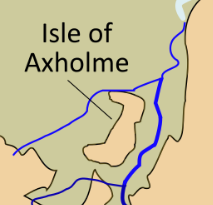
The name Isle is given to the area since, prior to the area being drained by the Dutchman Cornelius Vermuyden in the 17th century, each town or village was built on areas of dry, raised ground in the surrounding marshland. The River Don used to flow to the north and west (it has since been diverted), dividing the Isle from Yorkshire; the River Idle separates the Isle from Nottinghamshire; and the River Trent separates the Isle from the rest of Lincolnshire. Three towns developed here: Epworth, Crowle and Haxey.

The boundaries of the Isle of Axholme usually match with those of the ancient wapentake of Epworth [1] and its 17 communities as listed in the Domesday Book of 1086: Belton, Crowle, Epworth, Haxey, Beltoft, (High and Low) Burnham, Owston Ferry, (East) Lound and (Graise)lound, Garthorpe, Luddington, Amcotts, (West) Butterwick, Althorpe, The Marshes, Waterton, Upperthorpe, and Westwoodside. Other settlements on the Isle include Eastoft, Sandtoft – home to Europe's largest trolleybus museum – and Wroot.

Much of the northern part of the Isle has flat topography, with rich farmland used mainly to grow wheat and sugar beet. The land is particularly fertile due to its history of annual flooding from the Trent and peat soil which was created by dense ancient woodland which covered much of the Isle. Even today, in many parts of the northern Isle, petrified wood can be found at about six feet below ground; relics from this woodland, these are locally called "bog oaks".

A long-distance walking route, the "Peatlands Way", traverses the Isle. [2] [3]

Etymology

Axholme means "island by Haxey", from the town name + Old Norse holmr "island". The name was recorded as Hakirhomle in 1196. The Old English suffix "ey" in "Haxey" also indicates an island.

Historical descriptions

1833 description

Axholme, Isle of Area of slight elevation above flat and formerly marshy tract bounded by the Rivers Trent, Torne and Idle. Towns include Crowle, Belton, Epworth and Haxey on higher ground and Owston Ferry and West Butterwick beside the River Trent

Bartholomew's Gazetteer of Britain compiled by Oliver Mason (John Bartholomew, 1833)

1911 description

AXHOLME, an island in the north-west part of Lincolnshire, England, lying between the rivers Trent, Idle and Don, and isolated by drainage channels connected with these rivers. It consists mainly of a plateau of slight elevation, rarely exceeding 100 ft., and comprises the parishes of Althorpe, Belton, Epworth, Haxey, Luddington, Owston and Crowle; the total area being about 47,000 acres.

"Axholme". Encyclopædia Britannica . Vol. 3 (11th ed.). 1911. p. 68.

Land drainage history

"A true and perfect Plot of Hatfield Chase, in the Counties of York, Lincoln, and Nottingham as surveyed by Josias Acerlebout." from "The history of imbanking and drayning" by William Dugdale (1662). "A true and perfect Plot of Hatfield Chase, in the Counties of York, Lincoln, and Nottingham as surveyed by Josias Acerlebout." (1662).jpg
"A true and perfect Plot of Hatfield Chase, in the Counties of York, Lincoln, and Nottingham as surveyed by Josias Acerlebout." from "The history of imbanking and drayning" by William Dugdale (1662).

The Isle is known for the early influence of Cornelius Vermuyden, a Dutch engineer who initiated the realignment of several of the highland carriers flowing through the district. To carry out the work he brought in a large number of Flemish workers, many of whom settled permanently despite violent opposition from the established population. [4] The drainage allowed increased agricultural production, and has left a legacy in the unique strip farming which survives in the 21st century around Epworth. The watercourses of the Isle and the surrounding area are managed by the Isle of Axholme Internal Drainage Board which maintains 188 miles (302 km) of watercourse and 18 pumping stations, [5] and manages the water levels of the adjacent Thorne Moors and Hatfield Moors, both environmentally sensitive areas.

Road and railway

The Axholme Joint Railway traversed the area, but the line has now been abandoned. There are still railway stations in Crowle and Althorpe on the line between Scunthorpe and Sheffield. The M180 motorway now crosses the centre of the area, dividing 'South Axholme', centred on Epworth, from 'North Axholme', centred on Crowle. The A161 road crosses the Isle from north to south.

Governance

There was an Isle of Axholme Rural District from 1894 to 1974, which covered the entire Isle after 1936. This became part of the Boothferry district of Humberside in 1974, and since 1996 has been in the North Lincolnshire unitary authority.

Following boundary changes in 2023, the isle will be part of the new Doncaster East and the Isle of Axholme parliamentary constituency.

Notes

  1. "Hundred of Epworth". Domesday Book. opendomesday.org. Retrieved 31 January 2022.
  2. "Peatlands Way". www.ldwa.org.uk. Long Distance Walkers Association. Retrieved 31 January 2022.
  3. "The Peatlands Way". thepeatlandsway.com. Retrieved 31 January 2022.
  4. Chisholm, Hugh, ed. (1911). "Axholme"  . Encyclopædia Britannica . Vol. 3 (11th ed.). Cambridge University Press. p. 68.
  5. Isle of Axholme Internal Drainage Board website Archived 4 October 2011 at the Wayback Machine

Related Research Articles

<span class="mw-page-title-main">North Lincolnshire</span> Borough in Lincolnshire, England

North Lincolnshire is a unitary authority area with borough status in Lincolnshire, England. At the 2011 Census, it had a population of 167,446. The administrative centre and largest settlement is Scunthorpe, and the borough also includes the towns of Brigg, Broughton, Haxey, Crowle, Epworth, Bottesford, Winterton, Kirton in Lindsey and Barton-upon-Humber. North Lincolnshire is part of the Yorkshire and the Humber region.

<span class="mw-page-title-main">Epworth, Lincolnshire</span> Town and civil parish in Lincolnshire, England

Epworth is a town and civil parish on the Isle of Axholme, in the North Lincolnshire unitary authority of Lincolnshire, England. The town lies on the A161, about halfway between Goole and Gainsborough. As the birthplace of John Wesley and Charles Wesley, it has given its name to many institutions associated with Methodism. Their father, Samuel Wesley, was the rector from 1695 to 1735.

<span class="mw-page-title-main">Crowle, Lincolnshire</span> Town in North Lincolnshire, England

Crowle is a market town in the civil parish of Crowle and Ealand, on the Isle of Axholme in the North Lincolnshire unitary authority of Lincolnshire, England. The civil parish had a population at the 2011 census of 4,828. The town lies on the Stainforth and Keadby Canal.

<span class="mw-page-title-main">Axholme Joint Railway</span> Successor to the Goole and Marshland Railway and Axholme Light Railway

The Axholme Joint Railway was a committee created as a joint enterprise between the Lancashire and Yorkshire Railway (L&Y) and the North Eastern Railway (NER) and was established by the North Eastern Railway Act of 31 July 1902. It took over the Goole and Marshland Railway, running from Marshland Junction near Goole to Reedness Junction and Fockerby, and the Isle of Axholme Light Railway, running from Reedness Junction to Haxey Junction. Construction of the Goole and Marshland Railway had begun in 1898, and by the time of the takeover in early 1903, was virtually complete. The Isle of Axholme Light Railway was started in 1899, but only the section from Reedness Junction to Crowle was complete at the takeover. The northern section opened on 10 August 1903, and the line from Crowle to Haxey Junction opened for passengers on 2 January 1905.

<span class="mw-page-title-main">Althorpe</span> Small village in North Lincolnshire, England

Althorpe is a small village and former civil parish, now in the parish of Keadby with Althorpe, in the North Lincolnshire district, in the ceremonial county of Lincolnshire, England. It is four miles (6 km) west of Scunthorpe and the same distance south-east of Crowle, on the A18 road.

<span class="mw-page-title-main">Hatfield Chase</span> Human settlement in England

Hatfield Chase is a low-lying area in South Yorkshire and North Lincolnshire, England, which was often flooded. It was a royal hunting ground until Charles I appointed the Dutch engineer Cornelius Vermuyden to drain it in 1626. The work involved the re-routing of the Rivers Don, Idle, and Torne, and the construction of drainage channels. It was not wholly successful, but changed the whole nature of a wide swathe of land including the Isle of Axholme, and caused legal disputes for the rest of the century. The civil engineer John Smeaton looked at the problem of wintertime flooding in the 1760s, and some remedial work was carried out.

<span class="mw-page-title-main">Boothferry (district)</span> Former local government district in England

The Borough of Boothferry was, from 1 April 1974 to 1 April 1996, a local government district with borough status within the non-metropolitan county of Humberside. The district is now split between the East Riding of Yorkshire and North Lincolnshire.

<span class="mw-page-title-main">Isle of Axholme Rural District</span>

Isle of Axholme was a rural district in Lincolnshire, Parts of Lindsey from 1894 to 1974. It was formed under the Local Government Act 1894 based on the Lincolnshire parts of the Thorne rural sanitary district and two parishes of the Goole RSD.

<span class="mw-page-title-main">Luddington, Lincolnshire</span> Village in North Lincolnshire, England

Luddington is a village and former civil parish, now in the parish of Luddington with Haldenby, on the Isle of Axholme in the North Lincolnshire district, in the ceremonial county of Lincolnshire, England. The population of the civil parish of "Luddington with Haldenby" at the 2011 census was 419. It is 6 miles (10 km) north-west from Scunthorpe, 6 miles south-east from Goole and 18 miles (29 km) north-east from Doncaster.

<span class="mw-page-title-main">Eastoft</span> Village and civil parish in North Lincolnshire, England

Eastoft is a village and civil parish in North Lincolnshire, England. It is situated within the Isle of Axholme, 3 miles (5 km) north-east from Crowle, and on the A161 road.

<span class="mw-page-title-main">Owston Ferry</span> Village in Lincolnshire, England

Owston Ferry is a village and civil parish in North Lincolnshire, England. It is situated on the west bank of the River Trent, and 9 miles (14 km) north from Gainsborough. It had a total resident population of 1,128 in 2001 including Kelfield. This increased to 1,328 at the 2011 census. Sometimes referred to as Owston or Ferry, the village forms part of the Isle of Axholme. It is bounded to the west by the A161 road and the village of Haxey. The River Trent is directly to the east. To the north, beyond a number of hamlets and villages, lies the Humber estuary. West Butterwick was originally a part of the township of Owston.

<span class="mw-page-title-main">Haxey</span> Town in North Lincolnshire, England

Haxey is a town and civil parish on the Isle of Axholme in the North Lincolnshire unitary authority of Lincolnshire, England. It is directly south of Epworth, south-west of Scunthorpe, north-west of Gainsborough, east of Doncaster and north-north-west of Lincoln, with a population of 4,584 at the 2011 census. The town was regarded as the historic capital of the Isle of Axholme.

<span class="mw-page-title-main">Garthorpe, Lincolnshire</span> Village in North Lincolnshire, England

Garthorpe is a village in the North Lincolnshire, England. It is situated approximately 8 miles (13 km) south-east from Goole, 1 mile (1.6 km) west from the River Trent, and in the Isle of Axholme.

<span class="mw-page-title-main">Reedness Junction railway station</span> Disused railway station in the East Riding of Yorkshire, England

Reedness Junction railway station was a railway junction near Reedness, East Riding of Yorkshire, England on the Axholme Joint Railway. Immediately to the west of the station, the Fockerby Branch, which continued eastwards, turned off from the main line to Epworth, which curved to the south.

<span class="mw-page-title-main">Graizelound</span> Hamlet in the civil parish of Haxey in North Lincolnshire, England

Graizelound is a hamlet in the civil parish of Haxey in North Lincolnshire, England. It is approximately 22 miles (35 km) to the north-west from the city and county town of Lincoln, and centred on the crossroad junction of Haxey Lane, Station Road, Akeferry Road and Ferry Road. The village of Haxey is less than 1 mile (1.6 km) to the north. Owston Ferry on the River Trent is 2.5 miles (4.0 km) to the north-east. Graizelound forms part of the Isle of Axholme.

<span class="mw-page-title-main">River Torne (England)</span> River in the north of England

The River Torne is a river in the north of England, which flows through the counties of South Yorkshire and North Lincolnshire. It rises at the Upper Lake at Sandbeck Hall, in Maltby in South Yorkshire, and empties into the River Trent at Keadby pumping station. Much of the channel is engineered, as it plays a significant role in the drainage of Hatfield Chase, which it crosses.

<span class="mw-page-title-main">Pauper's Drain</span> Watercourse in north Lincolnshire, England

Pauper’s Drain is a small tributary of the River Trent in North Lincolnshire, England, and is 9 km long.

<span class="mw-page-title-main">East Lound</span> Hamlet in the civil parish of Haxey in North Lincolnshire, England

East Lound is a hamlet in the civil parish of Haxey in North Lincolnshire, England. It is situated approximately 22 miles (35 km) to the north-west from the city and county town of Lincoln, and on Brackenhill Road within the parish of Haxey, a village less than 1 mile (1.6 km) to the west. Owston Ferry on the River Trent is 1.5 miles (2.4 km) to the east. East Lound forms part of the Isle of Axholme.

References

53°30′N0°52′W / 53.50°N 0.86°W / 53.50; -0.86