
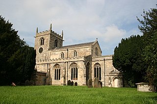
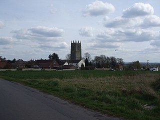
Epworth is a town and civil parish in the Isle of Axholme, North Lincolnshire, England. The town lies on the A161, about halfway between Goole and Gainsborough. As the birthplace of John Wesley and Charles Wesley, it has given its name to many institutions associated with Methodism. Their father, Samuel Wesley, was the rector from 1695 to 1735.

Crowle is a town in the civil parish of Crowle and Ealand, on the Isle of Axholme in North Lincolnshire, England. The civil parish had a population at the 2011 census of 4,828. It lies on the Stainforth and Keadby Canal and has a railway station. The place has a further named neighbourhood, Windsor.

Sir Cornelius Vermuyden was a Dutch engineer who introduced Dutch land reclamation methods to England. Commissioned by the Crown to drain Hatfield Chase in the Isle of Axholme, Lincolnshire, Vermuyden was knighted in 1629 for his work and became an English citizen in 1633. In the 1650s, he directed major projects to drain The Fens of East Anglia, introducing the innovation of constructing washes, to allow periodic flooding of the area by excess waters.
The Isle of Axholme is a geographical area in England: a part of North Lincolnshire that adjoins South Yorkshire. It is located between the towns of Scunthorpe and Gainsborough, both of which are in the traditional West Riding of Lindsey, and Doncaster.

Althorpe is a small village in North Lincolnshire, England, four miles (6 km) west of Scunthorpe and the same distance south-east of Crowle, on the A18 road. The population details are included in the civil parish of Keadby with Althorpe.
Belton is a village and civil parish in the Isle of Axholme area of North Lincolnshire, England. It is situated on the A161 road, and approximately 6 miles (10 km) east from Scunthorpe. To the north of Belton is the town of Crowle; to the south, the town of Epworth.
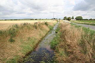
Hatfield Chase is a low-lying area in South Yorkshire and North Lincolnshire, England, which was often flooded. It was a royal hunting ground until Charles I appointed the Dutch engineer Cornelius Vermuyden to drain it in 1626. The work involved the re-routing of the Rivers Don, Idle and Torne, and the construction of drainage channels. It was not wholly successful, but changed the whole nature of a wide swathe of land including the Isle of Axholme and caused legal disputes for the rest of the century. The civil engineer John Smeaton looked at the problem of wintertime flooding in the 1760s, and some remedial work was carried out.

West Butterwick is a village and civil parish in North Lincolnshire, England. It lies in the Isle of Axholme, approximately 4 miles (6 km) north-east from Epworth and 4 miles north from Owston Ferry, on the western bank of the River Trent opposite its neighbour East Butterwick.

Isle of Axholme was a rural district in Lincolnshire, Parts of Lindsey from 1894 to 1974. It was formed under the Local Government Act 1894 based on the Lincolnshire parts of the Thorne rural sanitary district and two parishes of the Goole RSD.

The Trolleybus Museum at Sandtoft is a transport museum which specialises in the preservation of trolleybuses. It is located by the village of Sandtoft, near Belton on the Isle of Axholme in the English county of Lincolnshire.
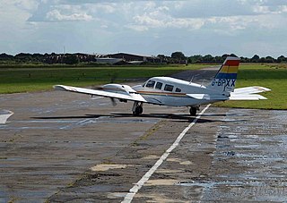
Sandtoft Airfield, also known as Sandtoft Aerodrome, is in Belton, North Lincolnshire, England on the south side of the M180 motorway, approximately 12 mi (19 km) northeast of Doncaster, and 7 nautical miles southwest of Scunthorpe. It is managed and operated by E-Plane Ltd. The Sandtoft Flying Club operates a flying school and cafe at the airfield.

Royal Air Force Sandtoft or more simply RAF Sandtoft is a former Royal Air Force station in North Lincolnshire between Doncaster, South Yorkshire and Scunthorpe, North Lincolnshire, England.
Eastoft is a village and civil parish in North Lincolnshire, England. It is situated within the Isle of Axholme, 3 miles (5 km) north-east from Crowle, and on the A161 road.

Owston Ferry is a village and civil parish in North Lincolnshire, England. It is situated on the west bank of the River Trent, and 9 miles (14 km) north from Gainsborough. It had a total resident population of 1,128 in 2001 including Kelfield. This increased to 1,328 at the 2011 census. Sometimes referred to as Owston or Ferry, the village forms part of the Isle of Axholme. It is bounded to the west by the A161 road and the village of Haxey. The River Trent is directly to the east. To the north, beyond a number of hamlets and villages, lies the River Humber. West Butterwick was originally a part of the township of Owston.
Haxey is a town and civil parish on the Isle of Axholme in North Lincolnshire, England. Directly south of Epworth, south west of Scunthorpe, north west of Gainsborough and north-west of the Lincoln, with a population of 4,584 at the 2011 census. The town was regarded as the historic capital of the Isle of Axholme.
Garthorpe is a village in North Lincolnshire, England. It is situated approximately 8 miles (13 km) south-east from Goole, 1 mile (1.6 km) west from the River Trent, and in the Isle of Axholme. Together with Fockerby, which is contiguous with the village, Garthorpe forms a civil parish of about 500 inhabitants, measured as 418 in the 2011 census.

Haxey Junction railway station was a station south of the town of Haxey, on the Isle of Axholme in Lincolnshire, England. It was the terminus of the Axholme Joint Railway which ran from Marshland Junction near Goole, and was adjacent to Haxey and Epworth station on the Great Northern and Great Eastern Joint Railway line which ran from Doncaster to Lincoln. Both stations are now closed, although the former Great Northern and Great Eastern Joint Railway line is still operational.
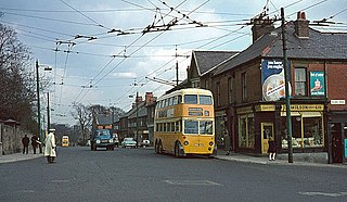
The Newcastle upon Tyne trolleybus system once served the city of Newcastle upon Tyne in England. Opened in 1935, it gradually replaced the Newcastle tram network.
South Axholme Academy is an academy school in Epworth, in the Isle of Axholme area of North Lincolnshire, England.

East Lound is a hamlet in the civil parish of Haxey in North Lincolnshire, England. It is situated approximately 22 miles (35 km) to the north-west from the city and county town of Lincoln, and on Brackenhill Road within the parish of Haxey, a village less than 1 mile (1.6 km) to the west. Owston Ferry on the River Trent is 1.5 miles (2.4 km) to the east. East Lound forms part of the Isle of Axholme.

