Related Research Articles

Teton County is a county in the U.S. state of Wyoming. As of the 2020 United States Census, the population was 23,331. Its county seat is Jackson. Its west boundary line is also the Wyoming state boundary shared with Idaho and the southern tip of Montana. Teton County is part of the Jackson, WY-ID Micropolitan Statistical Area. Teton County contains the Jackson Hole ski area, all of Grand Teton National Park, and 40.4% of Yellowstone National Park's total area, including over 96.6% of its water area.

The Kingsville Micropolitan Statistical Area is a micropolitan area in South Texas that covers two counties – Kleberg and Kenedy. As of the 2000 census, the μSA had a population of 31,963. It is also part of the larger Corpus Christi-Kingsville Combined Statistical Area.

The Mitchell Micropolitan Statistical Area, as defined by the United States Census Bureau, is an area consisting of two counties in South Dakota, anchored by the city of Mitchell. As of the 2000 census, the μSA had a population of 21,880.

The Pierre Micropolitan Statistical Area, as defined by the United States Census Bureau, is an area consisting of two counties in South Dakota, anchored by the state capital city, Pierre. As of the 2000 census, the μSA had a population of 19,253.

The Kearney Micropolitan Statistical Area, as defined by the United States Census Bureau, is an area consisting of two counties in Nebraska, anchored by the city of Kearney.

The Rexburg Micropolitan Statistical Area, as defined by the United States Census Bureau, is an area consisting of two counties in eastern Idaho, anchored by the city of Rexburg.

The Burley Micropolitan Statistical Area, as defined by the United States Census Bureau, is an area consisting of two counties in the Magic Valley region of Idaho, anchored by the city of Burley. It is commonly referred to locally as the "Mini-Cassia" area, an amalgam of Minidoka and Cassia Counties.
The Ontario Micropolitan Statistical Area, as defined by the United States Census Bureau, is an area consisting of two counties – one in southeastern Oregon and one in southwestern Idaho, anchored by the city of Ontario.
The Tullahoma-Manchester Micropolitan Statistical Area, as defined by the United States Census Bureau, is an area consisting of three counties in central Tennessee, anchored by the cities of Tullahoma and Manchester.

The New Bern Metropolitan Statistical Area, as defined by the United States Census Bureau, is an area consisting of three counties in the Inner Banks region of eastern North Carolina, anchored by the city of New Bern. The designation of the area was changed from Micropolitan to Metropolitan in 2013.

The Roanoke Rapids Micropolitan Statistical Area (μSA) as defined by the United States Census Bureau, is an area consisting of two counties in North Carolina, anchored by the city of Roanoke Rapids.
The Paducah, KY-IL Micropolitan Statistical Area, as defined by the United States Census Bureau, is an area consisting of five counties – three in the Jackson Purchase region of Kentucky, a fourth Kentucky county bordering the Purchase, and one in southern Illinois – anchored by the city of Paducah, Kentucky.
The Burlington, IA-IL Micropolitan Statistical Area, as defined by the United States Census Bureau, is an area consisting of two counties – one in southeast Iowa and the other in west central Illinois, anchored by the city of Burlington, Iowa.
The Waycross Micropolitan Statistical Area (μSA), as defined by the United States Census Bureau, is an area consisting of two counties in Georgia, anchored by the city of Waycross.

The Brainerd Micropolitan Statistical Area, as defined by the United States Census Bureau, is an area consisting of Cass County and Crow Wing County in Northern Minnesota, anchored by the city of Brainerd. As of February 4, 2011 estimate placed the population at 91,067.

The Martinsville Micropolitan Statistical Area is a United States Micropolitan Statistical Area (USA) in Virginia, as defined by the Office of Management and Budget (OMB) as of June, 2003. As of the 2000 census, the μSA had a population of 73,346.
The Iron Mountain Micropolitan Statistical Area, as defined by the United States Census Bureau, is an area consisting of two counties – one in Michigan and one in Wisconsin – anchored by the city of Iron Mountain, Michigan. As of the 2000 census, the μSA had a population of 32,560.

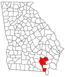
The Dublin Micropolitan Statistical Area, as defined by the United States Census Bureau, is an area consisting of two counties in Georgia, anchored by the city of Dublin.

The Milledgeville Micropolitan Statistical Area, as defined by the United States Census Bureau, is an area consisting of two counties in Georgia, anchored by the city of Milledgeville.
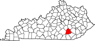
The London, KY Micropolitan Statistical Area is a United States Census Bureau defined Micropolitan Statistical Area located in the vicinity of London, Kentucky. The London Micropolitan Statistical Area encompasses Laurel County entirely. The Micropolitan Statistical Area had a population of 52,715 at the 2000 Census. A July 1, 2009 U.S. Census Bureau estimate placed the population at 57,749.
References
- ↑ "Annual Estimates of the Population of Metropolitan and Micropolitan Statistical Areas: April 1, 2000 to July 1, 2008 (CBSA-EST2007-01)". 2007 Population Estimates. United States Census Bureau, Population Division. 2008-03-27. Archived from the original (CSV) on July 9, 2010. Retrieved 2008-04-01.
- ↑ "U.S. Census website". United States Census Bureau . Retrieved 2008-01-31.

