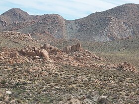
The New York Mountains are a small mountain range found in northeastern San Bernardino County in California, USA. The range's northeastern area lies in southeastern Nevada. The range lies just south of the small community of Ivanpah, and north of the Lanfair Valley. The mountains are part of the mountain ranges, cones, mountains, and landforms in the Mojave National Preserve. The mountains reach an elevation of 7,533 feet (2,296 m), and run in a mostly southwest-northeasterly direction between the Providence Mountains and the McCullough Range approximately five miles into Nevada and border the northwest corner of the Piute Valley of Nevada-California.

The Vallecito Mountains are located in the Colorado Desert, in eastern San Diego County, Southern California. They are about 28 miles (45 km) north of the U.S. border with Mexico.

Glass Mountain, on the Inyo National Forest, is one of the tallest peaks in Mono County, California. The peak lies 20 miles (32 km) southeast of the shoreline of Mono Lake and is the highest point on the four mile long sinuous Glass Mountain Ridge.

The Mohawk Mountains is a mountain range in the northwest Sonoran Desert of southwest Arizona. It abuts the western Gila River valley to the north, and is located in southern Yuma County. The Mohawk Valley lies adjacent and southwest of the range; the San Cristobal Valley is northeast.

The Meadow Valley Mountains is a mountain range in Lincoln and Clark counties in southern Nevada. The range is a narrow north to northeast trending ridgeline with a length of about 40 miles (64 km). The Clover Mountains lie to the north, Meadow Valley Wash and the Mormon Mountains to the east, the Moapa Valley to the southeast, Arrow Canyon Range to the south, Coyote Springs Valley to the southwest and the Kane Springs Valley and Delamar Mountains to the west and northwest.

The Little Ajo Mountains is a mountain range in southern Arizona, in extreme western Pima County, Arizona. The city of Ajo sits on the northeast of this small mountain range. Both the mountain range and city take their name from the Spanish word for garlic.

The Gap Mountains are a mountain range in eastern Nye County, Nevada. Gap Mountain along with Fox Mountain 7.5 miles (12.1 km) to the south and the hills between overlook the White River valley to the west. Gap Mountain lies just 1.5 mi (2.4 km) southwest of the southern end of the Egan Range of adjacent Lincoln County and appears to be an extension of that range. Fox Mountain lies about 5 miles west of the south end of the Schell Creek Range and 7 mi (11 km) northeast of the north end of the Seaman Range.The Grant Range and small Golden Gate Range lie to the west across the White River Valley.

The Bare Mountain Range is a mountain range in southern Nye County, Nevada, in the United States. Bare Mountain and Wildcat Peak are the high points of the range.
The Specter Range is a small mountain range in southeastern Nye County, Nevada.

The Coyote Mountains are a small mountain range in San Diego and Imperial Counties in southern California. The Coyotes form a narrow ESE trending 2 mi (3.2 km) wide range with a length of about 12 mi (19 km). The southeast end turns and forms a 2 mi (3.2 km) north trending "hook". The highest point is Carrizo Mountain on the northeast end with an elevation of 2,408 feet (734 m). Mine Peak at the northwest end of the range has an elevation of 1,850 ft (560 m). Coyote Wash along I-8 along the southeast margin of the range is 100 to 300 feet in elevation. Plaster City lies in the Yuha Desert about 5.5 mi (8.9 km) east of the east end of the range.

The Sawtooth Mountains are a mountain range of the Peninsular Ranges system, located in eastern San Diego County, California.
The Volcan Mountains are a mountain range of the Peninsular Ranges System, located in the East County region of San Diego County, California.

The Silver Bell Mountains are a northwest - southeast trending mountain range in north-central Pima County, Arizona. The range lies 14 miles (23 km) west of Marana, Arizona, located on Interstate-10, northwest of Tucson.

The San Luis Mountains are a small, lower elevation mountain range of central-southern Pima County Arizona adjacent to the U.S.-Mexico border, northeast of Sasabe, Arizona–Sasabe, Sonora.
The West Silver Bell Mountains are a small 10 mile (16 km) long mountain range of south-central Arizona, United States. The range lies in the north-central arid Sonoran Desert; the Madrean Sky Islands region of southeast Arizona, around Tucson is adjacent to the southeast.
The Antelope Valley of southern Eureka County is a small 35 mi long valley, surrounded by four mountain ranges. Antelope Wash flows north, to endorheic flatlands at the valley's north end. Eureka, Nevada lies 20 mi east nestled among mountain ranges. From Eureka U.S. Route 50 travels west through the north end of the valley on a route to Austin.

The Highland Range of Clark County, Nevada, is a small 10-mile (16 km) long, range south of Henderson, Nevada and separated from the southeast flank of the McCullough Range by a narrow, approximately three-mile wide valley, at the head of Piute Wash.

Sarcobatus Flat is a closed valley in western Nye County, Nevada between Goldfield and Beatty. The Bullfrog Hills form the southern boundary and the Grapevine Mountains along with Bonnie Claire Flat form the western boundary. Pahute Mesa bounds the area to the east and north. To the north the flat is contiguous with Lida Valley and Stonewall Flat.
The Las Guijas Mountains are a small northwest - southeast trending mountain range in southern Pima County, Arizona. The range is approximately 12 kilometres (7.5 mi) long by 4 km (2.5 mi). Surrounding ranges includes the Cerro Colorado Mountains to the northeast, the Tumacacori Mountains of Santa Cruz County to the east, the San Luis Mountains to the south and the Baboquivari Mountains across the Altar Valley to the west. Arivaca is immediately to the southeast and the old mining townsite of Las Guijas is in the wash just north of the range.
The Battle Mountains or Battle Mountain Range is a mountain range in western Lander and southeastern Humboldt counties of Nevada. The communities of Battle Mountain and Valmy lie just to the east and north respectively along Interstate 80 in the Humboldt River valley. Nevada State Route 305 runs along the southeast side of the range from Battle Mountain toward Austin to the south.