Related Research Articles

The Liverpool Overhead Railway was an overhead railway in Liverpool which operated along the Liverpool Docks and opened in 1893 with lightweight electric multiple units. The railway had a number of world firsts: it was the first electric elevated railway, the first to use automatic signalling, electric colour light signals and electric multiple units, and was home to one of the first passenger escalators at a railway station. It was the second oldest electric metro in the world, being preceded by the 1890 City and South London Railway.
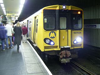
The Merseyrail Northern line is a cross-city railway running from Hunts Cross in south Liverpool then to termini in the north at Southport (Merseyside), Ormskirk (Lancashire) and Kirkby (Merseyside). It and the Wirral Line are commuter rail services operated by Merseyrail, serving Merseyside. A third line, the City Line, is not owned or operated by Merseyrail, although stations inside Merseytravel's area are branded as Merseyrail. All three lines are funded by Merseytravel.
Gladstone Dock was a station on the Liverpool Overhead Railway, between Alexandra Dock and Seaforth Sands. It was opened on 16 June 1930, the final station to open on the network.
Seaforth Sands was a terminus station located on the Liverpool Overhead Railway at Seaforth, west of Crosby Road South, Knowsley Road and Rimrose Road junctions.

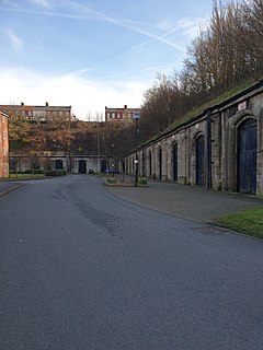
Dingle railway station is a disused underground railway station located on the Liverpool Overhead Railway (LOR), at the south end of Park Road, Dingle, Liverpool. It was the only below ground station on the line. Trains accessed the station via a half-mile tunnel, bored from the cliff face at Herculaneum Dock to Park Road. It is the last remaining part of the Overhead railway, with the surface entrance still standing. The former platform and track area were in use as a garage called Roscoe Engineering until 2015.
Canning railway station was a railway station on the Liverpool Overhead Railway.
Alexandra Dock was a station located on the Liverpool Overhead Railway, west of Regent Road (A565) and within the MDHC Dock Estate. The station was named after the adjacent Alexandra Dock.
Brunswick Dock railway station was on the Liverpool Overhead Railway, adjacent to Brunswick Dock and in close proximity to the Cheshire Lines Committee's extensive goods yard of the same name.

Wapping Dock railway station was on the Liverpool Overhead Railway, adjacent to the dock of the same name. It was primarily used for access to the large warehouses nearby.
Pier Head was a railway station on the Liverpool Overhead Railway. Opened on 6 March 1893 by the Marquis of Salisbury, it was located close to the landing stage of the Mersey Ferry, and next to the land on which the Royal Liver Building was built in 1911.
Princes Dock was a railway station on the Liverpool Overhead Railway, adjacent to the dock of the same name.
Clarence Dock was a railway station on the Liverpool Overhead Railway, adjacent to the dock of the same name.
Nelson Dock was a railway station on the Liverpool Overhead Railway, adjacent to the dock of the same name.
Sandon Dock was a railway station on the Liverpool Overhead Railway, adjacent to the dock of the same name.
Huskisson Dock was a railway station on the Liverpool Overhead Railway, adjacent to the dock of the same name. It was primarily used for access to the passenger liners, particularly those of Cunard and Ellerman.
Canada Dock station was on the Liverpool Overhead Railway, situated sixteen feet above street level between Canada Branch Dock No.1 dock to its west and the LNWR's Canada Dock goods station to the east; the LNWR's Canada Dock passenger station lay immediately east of the goods station.
Langton Dock was a railway station on the Liverpool Overhead Railway, adjacent to the dock of the same name.
Brocklebank Dock was a railway station on the Liverpool Overhead Railway, adjacent to the dock of the same name. It became particularly busy after Langton Dock station was closed in 1906, with workers of the Langton Dock using it instead.
Herculaneum Dock railway station was the original southern terminus for the Liverpool Overhead Railway. Actually adjacent to Harrington Dock it was named after Herculaneum Dock, a somewhat larger dock beyond the end of the line. It was opened on 6 March 1893 by the Marquis of Salisbury.
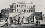
Liverpool in North West England, is a major British city with significant road, rail, and ferry networks, in addition to an international airport and a well-known dock system. As with most other major UK cities, Liverpool's transport infrastructure is centred on its road and rail networks. Public transport services within the city are controlled and run by Merseytravel.
References
- ↑ "The Dockers' Umbrella: City railway served Liverpool's busy port". Liverpool Echo. 23 April 2008. Retrieved 2 August 2015.
- ↑ Bolger, Paul (2007). The Docker's Umbrella: A History of Liverpool Overhead Railway. The Bluecoat Press. p. 46. ISBN 978-1872568058.