Jefferson, New Hampshire

Last updated

Jefferson, New Hampshire
Town
Coos-Jefferson-NH.png
Coordinates: 44°25′08″N71°28′28″W / 44.41889°N 71.47444°W / 44.41889; -71.47444
Country United States
State New Hampshire
County Coos
Incorporated 1796
Places
  • Jefferson
  • Jefferson Highland
  • Jefferson Station
  • Baileys
  • Highlands
  • Meadows
  • Riverton
  • Starr King
  • Waumbek Junction
Government
   Select board
  • Norman Brown, Chair
  • Terri Larcomb
  • Kevin Meehan
Area
[1]
  Total50.32 sq mi (130.34 km2)
  Land50.00 sq mi (129.49 km2)
  Water0.33 sq mi (0.85 km2)  0.66%
Elevation
1,381 ft (421 m)
Population
 (2020) [2]
  Total1,043
  Density21/sq mi (8.1/km2)
Time zone UTC-5 (Eastern)
  Summer (DST) UTC-4 (Eastern)
ZIP code
03583
Area code 603
FIPS code 33-38820
GNIS feature ID0873634
Website www.jeffersonnh.org

Jefferson is a town in Coos County, New Hampshire, United States. The population was 1,043 at the 2020 census. [2] It is home to parts of the White Mountain National Forest in the south and northeast and to Santa's Village, a Christmas-themed amusement park. There are also several private campgrounds, motels and inns.

Contents

Jefferson is part of the Berlin, New Hampshire-Vermont Micropolitan Statistical Area.

History

Carter's Tower in 1906 Carter's Tower, Jefferson, NH.jpg
Carter's Tower in 1906

Colonial Governor Benning Wentworth first made land grants in this area in 1765, but the location was so deep in unexplored territory that few settlers took up their claims. So soon after the French and Indian War, in which certain Native American tribes in New England were allied with the French, English colonists did not want to be exposed on the frontier.

Colonel Joseph Whipple (1738–1816) [3] [lower-alpha 1] took a grant and cut trails through the forests to build a "manor" house. He named the town "Dartmouth" after William Legge, 2nd Earl of Dartmouth, the patron of Dartmouth College. Brother to William Whipple, [3] a signer of the Declaration of Independence, Colonel Whipple renamed the town "Jefferson" four years prior to Thomas Jefferson's election as president. The state legislature granted the town a new charter as "Jefferson" on December 8, 1796.

In the mid-19th century, the boundary with the adjacent township of Kilkenny was moved so as to include that township's few residents in Jefferson.

Cherry Mountain from the Waumbek Hotel, c. 1910 Cherry Mountain from the Waumbek.jpg
Cherry Mountain from the Waumbek Hotel, c.1910

Thaddeus S. C. Lowe, a local farm boy born in 1832, became a world-famous inventor of aerostats (dirigibles) and other devices. Consulting President Abraham Lincoln, he organized a balloon corps during the Civil War, and went on to invent the ice-making machine, and later the water-gas process. For years, the latter was used to fuel gas lights in hundreds of cities. His father, Clovis Lowe, had been part owner in 1832 of nearby Low and Burbank's Grant, which contains much of Mount Adams and Mount Madison. Lowe is featured on a New Hampshire historical marker (number 19) in Jefferson.

In 1885, a landslide on the north side of Cherry Mountain demolished the Stanley farm, mortally wounding a worker. Local hotels immediately arranged daily excursions to view the scene, now marked by a New Hampshire historical marker (number 152) titled "Cherry Mountain Slide". [4] Jefferson's third marker (number 229) honors Deborah Vicker, known as "Granny Stalbird", [4] who is said to have brought the first bible to the north country.

The Waumbek c. 1905 The Waumbek Hotel, Jefferson, NH.jpg
The Waumbek c.1905

During the early 1900s, Jefferson was a popular summer resort, boasting one of the largest "grand hotels" in the White Mountains—the Waumbek, with accommodations for nearly 300 guests. The hotel had its own rail branch, to deliver guests directly to the hotel from Boston and New York without changing trains. It was destroyed by fire on May 9, 1928.

At tourism's peak, Jefferson had over 30 inns and boarding houses, accessible by several mainline depots, including Riverton, Baileys, Meadows, and Highlands. Some of the original station buildings remain, although most have been moved to nearby locations. The tracks were removed in the 1920s. The wider ownership of automobiles gave people more choices for vacation destinations, and the Great Depression reduced vacations for years. By the end of this period, many people sought other venues than grand hotels.

A number of historic, architecturally interesting structures remain from the resort era. The Waumbek Cottages provided a backdrop for the popular White Mountains Festival of the Arts until 1979. In March 2006, the Waumbek Cottages Historic District was listed in the National Register of Historic Places.

In 1988 and 1989, Jefferson gained national attention when a local volunteer firefighter was charged and tried in connection with dozens of arson fires that had plagued the area. The defendant was acquitted at trial. [5] [6] [7] [8]

Geography

Presidential Range c. 1905 Presidential Range, Jefferson, NH.jpg
Presidential Range c.1905

Jefferson is located on U.S. Route 2 between Lancaster and Randolph, west of the midpoint between the Vermont and Maine borders. Set astride the broad Israel River valley, the town commands remarkable views of the Presidential Range and other White Mountain summits. Mount Starr King, with an elevation of 3,907 feet (1,191 m) and named for Thomas Starr King, is the highest point in town, near the town's northern border. It is regularly traversed by hikers scaling nearby 4,006-foot (1,221 m) Mount Waumbek, one of the "four-thousand footers"—the 48 peaks above 4,000 feet (1,200 m) in New Hampshire. [9] Jefferson lies fully within the Connecticut River watershed. [10]

In the past few years, thousands of acres of Jefferson have been sold or donated by private interests to the White Mountain National Forest. These include the Randolph Town Forest, a part of which is within the boundaries of Jefferson, the Silvio O. Conte National Fish and Wildlife Refuge, and Mount Starr King.

According to the United States Census Bureau, the town has a total area of 50.3 square miles (130.3 km2), of which 50.0 square miles (129.5 km2) are land and 0.3 square miles (0.9 km2) are water, comprising 0.66% of the town. [1]

Climate

According to the Köppen Climate Classification system, Jefferson has a warm-summer humid continental climate, abbreviated "Dfb" on climate maps.

Climate data for Jefferson, New Hampshire, 1991–2020 normals, extremes 2000–present
MonthJanFebMarAprMayJunJulAugSepOctNovDecYear
Record high °F (°C)62
(17)
65
(18)
78
(26)
86
(30)
93
(34)
94
(34)
94
(34)
92
(33)
92
(33)
80
(27)
71
(22)
62
(17)
94
(34)
Mean maximum °F (°C)50.5
(10.3)
50.1
(10.1)
58.4
(14.7)
75.3
(24.1)
84.1
(28.9)
87.6
(30.9)
88.8
(31.6)
85.9
(29.9)
84.3
(29.1)
72.4
(22.4)
64.1
(17.8)
51.5
(10.8)
90.6
(32.6)
Mean daily maximum °F (°C)26.2
(−3.2)
28.8
(−1.8)
37.5
(3.1)
50.9
(10.5)
64.4
(18.0)
72.6
(22.6)
77.6
(25.3)
75.9
(24.4)
67.4
(19.7)
55.3
(12.9)
41.5
(5.3)
30.9
(−0.6)
52.4
(11.4)
Daily mean °F (°C)16.8
(−8.4)
19.0
(−7.2)
27.6
(−2.4)
40.6
(4.8)
53.1
(11.7)
61.6
(16.4)
66.7
(19.3)
64.8
(18.2)
56.4
(13.6)
46.0
(7.8)
34.0
(1.1)
23.3
(−4.8)
42.5
(5.8)
Mean daily minimum °F (°C)7.4
(−13.7)
9.1
(−12.7)
17.8
(−7.9)
30.3
(−0.9)
41.7
(5.4)
50.5
(10.3)
55.8
(13.2)
53.6
(12.0)
45.4
(7.4)
36.7
(2.6)
26.5
(−3.1)
15.7
(−9.1)
32.5
(0.3)
Mean minimum °F (°C)−14.0
(−25.6)
−9.7
(−23.2)
−4.3
(−20.2)
18.8
(−7.3)
30.4
(−0.9)
39.2
(4.0)
45.9
(7.7)
42.7
(5.9)
31.8
(−0.1)
24.9
(−3.9)
10.8
(−11.8)
−4.2
(−20.1)
−16.6
(−27.0)
Record low °F (°C)−31
(−35)
−22
(−30)
−17
(−27)
8
(−13)
25
(−4)
32
(0)
40
(4)
36
(2)
21
(−6)
16
(−9)
−2
(−19)
−16
(−27)
−31
(−35)
Average precipitation inches (mm)2.51
(64)
2.28
(58)
2.61
(66)
3.36
(85)
3.80
(97)
4.40
(112)
4.26
(108)
3.98
(101)
3.34
(85)
4.29
(109)
2.95
(75)
3.26
(83)
41.04
(1,043)
Average snowfall inches (cm)20.1
(51)
19.8
(50)
16.7
(42)
6.5
(17)
0.5
(1.3)
0.0
(0.0)
0.0
(0.0)
0.0
(0.0)
0.0
(0.0)
1.8
(4.6)
7.7
(20)
21.7
(55)
94.8
(240.9)
Average precipitation days (≥ 0.01 in)16.313.514.113.614.514.512.912.210.614.414.516.9168
Average snowy days (≥ 0.1 in)15.313.210.54.90.50.00.00.00.01.47.713.767.2
Source 1: NOAA [11]
Source 2: National Weather Service (mean maxima and minima 20062020) [12]

Demographics

Historical population
CensusPop.Note
1800 112
1810 19775.9%
1820 25227.9%
1830 49295.2%
1840 57516.9%
1850 6299.4%
1860 70011.3%
1870 82618.0%
1880 95115.1%
1890 1,06211.7%
1900 1,0801.7%
1910 1,061−1.8%
1920 960−9.5%
1930 771−19.7%
1940 763−1.0%
1950 728−4.6%
1960 600−17.6%
1970 71419.0%
1980 80312.5%
1990 96520.2%
2000 1,0064.2%
2010 1,10710.0%
2020 1,043−5.8%
U.S. Decennial Census [2] [13]
Highland House c. 1910 Highland House, Jefferson, NH.jpg
Highland House c.1910

As of the census [14] of 2000, there were 1,006 people, 407 households, and 295 families residing in the town. The population density was 20.1 inhabitants per square mile (7.8/km2). There were 582 housing units at an average density of 11.6 per square mile (4.5/km2). The racial makeup of the town was 98.31% White, 0.10% Native American, 0.10% Asian, 0.10% Pacific Islander, and 1.39% from two or more races. Hispanic or Latino of any race were 0.10% of the population.

There were 407 households, out of which 28.0% had children under the age of 18 living with them, 62.4% were married couples living together, 5.2% had a female householder with no husband present, and 27.5% were non-families. 20.4% of all households were made up of individuals, and 6.9% had someone living alone who was 65 years of age or older. The average household size was 2.47 and the average family size was 2.84.

Pliny Range House in 1911 Pliny Range House, Jefferson, NH.jpg
Pliny Range House in 1911

In the town, the population was spread out, with 22.0% under the age of 18, 4.5% from 18 to 24, 27.2% from 25 to 44, 32.4% from 45 to 64, and 13.9% who were 65 years of age or older. The median age was 43 years. For every 100 females, there were 103.6 males. For every 100 females age 18 and over, there were 105.0 males.

The median income for a household in the town was $41,089, and the median income for a family was $42,067. Males had a median income of $27,130 versus $21,382 for females. The per capita income for the town was $19,556. About 4.7% of families and 8.2% of the population were below the poverty line, including 12.0% of those under age 18 and 9.9% of those age 65 or over.

Sites of interest

Notable person

See also

Notes

  1. Colonel Joseph Whipple of Jefferson is a different person than the like-named Colonel Joseph Whipple of Rhode Island, who died in 1746.

Related Research Articles

<span class="mw-page-title-main">Coös County, New Hampshire</span> County in New Hampshire, United States

Coös County or Coos County is a county in the U.S. state of New Hampshire. As of the 2020 census, the population was 31,268, making it the least-populated county in the state. The county seat is Lancaster.

<span class="mw-page-title-main">Hart's Location, New Hampshire</span> Town in New Hampshire, United States

Hart's Location is a town in Carroll County, New Hampshire, United States. Since 1948, the town has frequently been one of the first places to declare its results for the New Hampshire presidential primary and U.S. presidential elections.

<span class="mw-page-title-main">Carroll, New Hampshire</span> Town in New Hampshire, United States

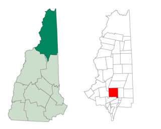
Carroll is a town in Coös County, New Hampshire, United States. The population was 820 at the 2020 census. The two largest villages are Twin Mountain and Bretton Woods. Carroll is an important access point for recreational areas in the White Mountains, including many 4,000-footers, the Zealand River area, the Presidential Range, and the Presidential Dry River Wilderness. The town is home to the Mount Washington Hotel at Bretton Woods and to the Highland Center at Crawford Notch, the Appalachian Mountain Club's four-season lodge.

<span class="mw-page-title-main">Clarksville, New Hampshire</span> Town in New Hampshire, United States

Clarksville is a town in northern Coös County, New Hampshire, United States. The population was 294 at the 2020 census. It is part of the Berlin, NH-VT Micropolitan Statistical Area.

<span class="mw-page-title-main">Dixville, New Hampshire</span> Township in Coos County, New Hampshire, United States

Dixville is a township in Coös County, New Hampshire, United States. The population was 4 as of the 2020 census, down from 12 at the 2010 census. In New Hampshire, locations, grants, townships, and purchases are unincorporated portions of a county which are not part of any town and have limited self-government.

<span class="mw-page-title-main">Northumberland, New Hampshire</span> Town in New Hampshire, United States

Northumberland is a town located in western Coös County, New Hampshire, United States, north of Lancaster. It is part of the Berlin, NH–VT micropolitan statistical area. As of the 2020 census, the town population was 2,126, of whom 1,068 lived in the village of Groveton.

<span class="mw-page-title-main">Randolph, New Hampshire</span> Town in New Hampshire, United States

Randolph is a heavily forested town in Coös County, New Hampshire, United States, extending from the northern slopes of the White Mountains of the Presidential Range to the Crescent Range and Berlin, with U.S. Route 2 cutting through the middle. The northern and southern parts of Randolph are within the White Mountain National Forest and the Ice Gulch Town Forest, while the central part is the settled portion of town. As of the 2020 census, the town had a population of 328.

<span class="mw-page-title-main">Shelburne, New Hampshire</span> Town in New Hampshire, United States

Shelburne is a town in Coös County, New Hampshire, United States. The population was 353 at the 2020 census. It is located in the White Mountains, and part of the White Mountain National Forest is in the south. Shelburne is home to Leadmine State Forest. The Appalachian Trail crosses the town.

<span class="mw-page-title-main">Stark, New Hampshire</span> Town in New Hampshire, United States

Stark is a town in Coös County, New Hampshire, United States. The population was 478 at the 2020 census, a decline from the figure of 556 tabulated in 2010. It has a famous covered bridge. The town includes the villages of Percy and Crystal as well as the village of Stark, located on the Upper Ammonoosuc River. New Hampshire Route 110 runs through Stark, east from U.S. Highway 3 in Groveton and northwest from Route 16 in Berlin. Much of the town is within the boundaries of the White Mountain National Forest.

<span class="mw-page-title-main">Stewartstown, New Hampshire</span> Town in New Hampshire, United States

Stewartstown is a town in Coös County, New Hampshire, United States. The population was 813 at the 2020 census, down from 1,004 at the 2010 census. It includes the village of West Stewartstown and is part of the Berlin, NH-VT Micropolitan Statistical Area.

<span class="mw-page-title-main">Benton, New Hampshire</span> Town in New Hampshire, United States

Benton is a town in Grafton County, New Hampshire, United States. The population was 374 at the 2020 census. Located in the White Mountains, Benton is largely surrounded by the White Mountain National Forest. The town is crossed by the Appalachian Trail.

<span class="mw-page-title-main">Bethlehem, New Hampshire</span> Town in New Hampshire, United States

Bethlehem is a hillside town in Grafton County, New Hampshire, United States. The population was 2,484 at the 2020 census. It is home to Cushman and Strawberry Hill state forests. The eastern half of the town is within the White Mountain National Forest. The Appalachian Trail crosses a small portion of the town in the south.

<span class="mw-page-title-main">Orford, New Hampshire</span> Town in New Hampshire, United States

Orford is a town in Grafton County, New Hampshire, United States. The population was 1,237 at the 2020 census, unchanged from the 2010 census. The Appalachian Trail crosses in the east.

<span class="mw-page-title-main">New Boston, New Hampshire</span> Town in New Hampshire, United States

New Boston is a town in Hillsborough County, New Hampshire, United States. The population was 6,108 at the 2020 census, up from 5,321 at the 2010 census. New Boston is home to the annual Hillsborough County Agricultural Fair and the Molly Stark Cannon. The 1743 cannon, which appears on the town seal, was given by General John Stark to the New Boston Artillery Company after the Battle of Bennington.

<span class="mw-page-title-main">Greenland, New Hampshire</span> Place in New Hampshire, United States

Greenland is a town in Rockingham County, New Hampshire, United States. The population was 4,067 at the 2020 census, up from 3,549 at the 2010 census. It is drained by the Winnicut River and bounded on the northwest by Great Bay.

<span class="mw-page-title-main">Lancaster, New Hampshire</span> Town in New Hampshire, United States

Lancaster is a town located along the Connecticut River in Coös County, New Hampshire, United States. The town is named after the city of Lancaster in England. As of the 2020 census, the town population was 3,218, the second largest in the county after Berlin. It is the county seat of Coos County and gateway to the Great North Woods Region of the state. Lancaster, which includes the villages of Grange and South Lancaster, is home to Weeks State Park and the Lancaster Fair. Part of the White Mountain National Forest is in the eastern portion. The town is part of the Berlin, NH−VT Micropolitan Statistical Area.

<span class="mw-page-title-main">Whitefield, New Hampshire</span> Town in New Hampshire, United States

Whitefield is a town in Coös County, New Hampshire, United States, in the White Mountains Region. The population was 2,490 at the 2020 census. Situated on the northern edge of the White Mountains, Whitefield is home to the Mount Washington Regional Airport and the White Mountains Regional High School.

<span class="mw-page-title-main">New Hampshire Route 115A</span> State highway in New Hampshire, US

New Hampshire Route 115A is a 4.128-mile-long (6.643 km) north–south state highway in Coos County, New Hampshire. The southern terminus of the road is at New Hampshire Route 115 south of Jefferson at Old Cherry Mountain Road. The northern terminus of NH 115A is at U.S. Route 2 in Jefferson at the Old Corner Store.

<span class="mw-page-title-main">Kilkenny, New Hampshire</span> Township in Coos County, New Hampshire, United States

Kilkenny is a township in Coös County, New Hampshire, United States. It lies entirely within the White Mountain National Forest. As of the 2020 census, the township had a population of zero.

<span class="mw-page-title-main">Gorham, New Hampshire</span> Town in New Hampshire, United States

Gorham is a town in Coös County, New Hampshire, United States. The population was 2,698 at the 2020 census. Gorham is located in the White Mountains, and parts of the White Mountain National Forest are in the south and northwest. Moose Brook State Park is in the west. Tourism is a principal business. It is part of the Berlin, NH-VT Micropolitan Statistical Area.

References

  1. 1 2 "2021 U.S. Gazetteer Files – New Hampshire". United States Census Bureau. Retrieved November 9, 2021.
  2. 1 2 3 "Jefferson town, Coos County, New Hampshire: 2020 DEC Redistricting Data (PL 94-171)". U.S. Census Bureau. Retrieved November 9, 2021.
  3. 1 2 Bond, Charles D.; Bond, Marie R. (November 2002). "Mount Joseph Whipple: How and Why It Got Its Name" (PDF). Archived (PDF) from the original on December 27, 2004. Retrieved July 10, 2020 via whipple.org.{{cite journal}}: Cite journal requires |journal= (help)
  4. 1 2 "List of Markers by Marker Number" (PDF). nh.gov. New Hampshire Division of Historical Resources. November 2, 2018. Archived (PDF) from the original on January 27, 2013. Retrieved July 5, 2019.
  5. "Arsonist Taunts N.H. Town with 19th Fire", The Boston Globe, August 24, 1988
  6. "Ex-Fireman Charged in N.H. Arson", The Boston Globe, October 13, 1988
  7. "N.H. Man Cleared of Charge Related to Fire", The Boston Globe, April 8, 1989
  8. "N.H. Jurors Acquit Man of Arson Wave", The Boston Globe, July 1, 1989
  9. Gene Daniell and Jon Burroughs, ed., White Mountain Guide, 26th ed., Boston, Massachusetts, Appalachian Mountain Club, 1998
  10. Foster, Debra H.; Batorfalvy, Tatianna N.; Medalie, Laura (1995). Water Use in New Hampshire: An Activities Guide for Teachers. U.S. Department of the Interior and U.S. Geological Survey.
  11. "U.S. Climate Normals Quick Access". National Oceanic and Atmospheric Administration. Retrieved August 3, 2022.
  12. "NOAA Online Weather Data". National Weather Service. Retrieved August 3, 2022.
  13. "Census of Population and Housing". Census.gov. Retrieved June 4, 2016.
  14. "U.S. Census website". United States Census Bureau . Retrieved January 31, 2008.
  15. "New Hampshire - Silvio O. Conte - U.S. Fish and Wildlife Service". www.fws.gov. Retrieved September 24, 2017.