Whitefield (CDP), New Hampshire

Last updated

Whitefield, New Hampshire
USA New Hampshire location map.svg
Red pog.svg
Whitefield
Usa edcp location map.svg
Red pog.svg
Whitefield
Coordinates: 44°22′20″N71°36′42″W / 44.37222°N 71.61167°W / 44.37222; -71.61167
Country United States
State New Hampshire
County Coos
Town Whitefield
Area
[1]
  Total1.59 sq mi (4.13 km2)
  Land1.59 sq mi (4.13 km2)
  Water0.00 sq mi (0.00 km2)
Elevation
945 ft (288 m)
Population
 (2020)
  Total1,460
  Density915.93/sq mi (353.69/km2)
Time zone UTC-5 (Eastern (EST))
  Summer (DST) UTC-4 (EDT)
ZIP code
03598
Area code 603
FIPS code 33-84340
GNIS feature ID2378095

Whitefield is a census-designated place (CDP) and the main village in the town of Whitefield in Coos County, New Hampshire, United States. The population of the CDP was 1,460 at the 2020 census, [2] out of 2,490 people in the entire town of Whitefield.

Contents

Geography

The CDP is in the west-central part of the town of Whitefield, on both sides of the Johns River, a westward-flowing tributary of the Connecticut River. It extends north into the town of Dalton. The northern edge of the CDP is north of Meadowmist Drive and follows Mirror Lake Road, while to the east the CDP extends beyond Holly Heights and Balsam Lane. The southeastern border of the CDP runs east of Whitefield Elementary School, then follows Greenwood Street/South Whitefield Road south to Bog Brook, which forms the western border of the CDP down to the Johns River. [3]

U.S. Route 3 runs through the center of Whitefield, leading north 8 miles (13 km) to Lancaster, the Coos County seat, and south the same distance to Twin Mountain. New Hampshire Route 116 also passes through the center of town, leading northeastward 9 miles (14 km) to Jefferson and southwestward 10 miles (16 km) to Littleton. New Hampshire Route 142 leads northwest from Whitefield 7 miles (11 km) to Dalton and south-southwest 8 miles (13 km) to Bethlehem.

According to the U.S. Census Bureau, the Whitefield CDP has a total area of 1.6 square miles (4.1 km2), all of it recorded as land. [4]

Demographics

Historical population
CensusPop.Note
1950 1,329
1960 1,244−6.4%
1970 1,093−12.1%
1980 1,005−8.1%
1990 1,0413.6%
2000 1,0894.6%
2010 1,1424.9%
2020 1,46027.8%
U.S. Decennial Census [5]

As of the census of 2010, there were 1,142 people, 476 households, and 283 families residing in the CDP. There were 544 housing units, of which 68, or 12.5%, were vacant. The racial makeup of the town was 94.8% white, 0.2% African American, 0.5% Native American, 0.4% Asian, 0.0% Pacific Islander, 2.1% some other race, and 1.9% from two or more races. 3.6% of the population were Hispanic or Latino of any race. [6]

Of the 476 households in the CDP, 29.6% had children under the age of 18 living with them, 43.5% were headed by married couples living together, 11.8% had a female householder with no husband present, and 40.5% were non-families. 34.5% of all households were made up of individuals, and 15.8% were someone living alone who was 65 years of age or older. The average household size was 2.30, and the average family size was 2.92. [6]

23.3% of people in the CDP were under the age of 18, 6.7% were from age 18 to 24, 25.0% were from 25 to 44, 26.6% were from 45 to 64, and 18.5% were 65 years of age or older. The median age was 41.1 years. For every 100 females, there were 88.1 males. For every 100 females age 18 and over, there were 85.6 males. [6]

For the period 2011-15, the estimated median annual income for a household was $31,743, and the median income for a family was $46,597. Male full-time workers had a median income of $41,944 versus $32,311 for females. The per capita income for the CDP was $21,220. 17.3% of the population and 11.6% of families were below the poverty line, along with 16.5% of people under the age of 18 and 20.8% of people 65 or older. [7]

Related Research Articles

<span class="mw-page-title-main">Groveton, New Hampshire</span> Census-designated place in New Hampshire, United States

Groveton is a census-designated place (CDP) and the primary village in the town of Northumberland in Coos County, New Hampshire, United States. The population was 1,068 at the 2020 census. It is located at the intersection of U.S. Route 3 and New Hampshire Route 110.

<span class="mw-page-title-main">Suncook, New Hampshire</span> Census-designated place in New Hampshire, United States

Suncook is a census-designated place (CDP) in Merrimack County, New Hampshire, United States. The population was 5,501 at the 2020 census. Approximately two-thirds of Suncook is located in the town of Pembroke, with the remainder in Allenstown.

<span class="mw-page-title-main">Winchester (CDP), New Hampshire</span> Census-designated place in New Hampshire, United States

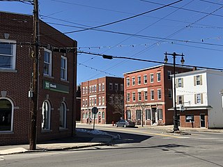
Winchester is a census-designated place (CDP) and the main village in the town of Winchester in Cheshire County, New Hampshire, United States. The population of the CDP was 1,606 at the 2020 census, compared to 4,150 in the entire town.

Gorham is a census-designated place (CDP) and the main village in the town of Gorham in Coos County, New Hampshire, United States. The population of the CDP was 1,851 at the 2020 census, out of 2,698 people in the entire town of Gorham.

Lancaster is a census-designated place (CDP) and the main village in the town of Lancaster in Coos County, New Hampshire, United States. The population of the CDP was 1,941 at the 2020 census, out of 3,218 in the entire town of Lancaster.

<span class="mw-page-title-main">Whitefield, New Hampshire</span> Town in New Hampshire, United States

Whitefield is a town in Coös County, New Hampshire, United States, in the White Mountains Region. The population was 2,490 at the 2020 census. Situated on the northern edge of the White Mountains, Whitefield is home to the Mount Washington Regional Airport and the White Mountains Regional High School.

<span class="mw-page-title-main">Bristol (CDP), New Hampshire</span> Census-designated place in New Hampshire, United States

Bristol is a census-designated place (CDP) and the main village in the town of Bristol in Grafton County, New Hampshire, United States. The population of the CDP was 1,911 at the 2020 census, out of 3,244 in the entire town.

Hanover is a census-designated place (CDP) and the main village in the town of Hanover in Grafton County, New Hampshire, United States. The population of the CDP was 9,078 at the 2020 census, out of 11,870 in the entire town. The CDP includes the campus of Dartmouth College.

Littleton is a census-designated place (CDP) and the main village in the town of Littleton in Grafton County, New Hampshire, United States. The population of the CDP was 4,467 at the 2020 census, out of 6,005 in the entire town.

<span class="mw-page-title-main">Plymouth (CDP), New Hampshire</span> Census-designated place in New Hampshire, United States

Plymouth is a census-designated place (CDP) and the main village in the town of Plymouth in Grafton County, New Hampshire, United States. Its population was 4,730 at the 2020 census, out of 6,682 in the entire town. The CDP includes the campus of Plymouth State University.

<span class="mw-page-title-main">Greenville (CDP), New Hampshire</span> Census-designated place in New Hampshire, United States

Greenville is a census-designated place (CDP) and the main village in the town of Greenville in Hillsborough County, New Hampshire, United States. The population of the CDP was 1,074 at the 2020 census, out of 1,974 in the entire town.

<span class="mw-page-title-main">Hampton (CDP), New Hampshire</span> Census-designated place in New Hampshire, United States

Hampton is a census-designated place (CDP) comprising the town center and surrounding developed areas of the town of Hampton, Rockingham County, New Hampshire, United States. The population of the CDP was 9,597 at the 2020 census, out of 16,214 in the entire town.

<span class="mw-page-title-main">Londonderry (CDP), New Hampshire</span> Census-designated place in New Hampshire, United States

Londonderry is a census-designated place (CDP) within the town of Londonderry in Rockingham County, New Hampshire, United States. The population of the CDP was 11,645 at the 2020 census, out of 25,826 in the entire town.

<span class="mw-page-title-main">Durham (CDP), New Hampshire</span> Census-designated place in New Hampshire, United States

Durham is a census-designated place (CDP) and the main village in the town of Durham in Strafford County, New Hampshire, United States. The population of the CDP was 11,147 at the 2020 census, out of 15,490 in the entire town. The CDP is home to the University of New Hampshire.

<span class="mw-page-title-main">Farmington (CDP), New Hampshire</span> Census-designated place in New Hampshire, United States

Farmington is a census-designated place (CDP) and the main village in the town of Farmington, Strafford County, New Hampshire, United States. The population of the CDP was 3,824 at the 2020 census, out of 6,722 in the entire town.

<span class="mw-page-title-main">West Stewartstown, New Hampshire</span> Census-designated place in New Hampshire, United States

West Stewartstown is a census-designated place in the town of Stewartstown in Coös County, New Hampshire, United States. It had a population of 263 at the 2020 census, down from 386 at the 2010 census.

<span class="mw-page-title-main">Newfields (CDP), New Hampshire</span> Census-designated place in New Hampshire, United States

Newfields is a census-designated place (CDP) and the main village within the town of Newfields, Rockingham County, New Hampshire, United States. The population of the CDP was 378 at the 2020 census, out of 1,769 in the entire town.

Bethlehem is a census-designated place (CDP) and the main village in the town of Bethlehem in Grafton County, New Hampshire, United States. The population of the CDP was 826 at the 2020 census, out of 2,484 in the entire town.

Canaan is a census-designated place (CDP) and the main village in the town of Canaan in Grafton County, New Hampshire, United States. The population of the CDP was 442 at the 2020 census, out of 3,794 in the entire town.

<span class="mw-page-title-main">Colebrook (CDP), New Hampshire</span> Census-designated place in New Hampshire, United States

Colebrook is a census-designated place (CDP) and the main village in the town of Colebrook, Coös County, New Hampshire, United States. The population of the CDP was 1,201 at the 2020 census, out of 2,084 in the entire town. The CDP population had dropped from 1,394 at the 2010 census.

References

  1. "ArcGIS REST Services Directory". United States Census Bureau. Retrieved September 20, 2022.
  2. "Whitefield CDP, New Hampshire: 2020 DEC Redistricting Data (PL 94-171)". U.S. Census Bureau. Retrieved November 18, 2021.
  3. "TIGERweb: Whitefield CDP, New Hampshire". Geography Division, U.S. Census Bureau. Retrieved January 25, 2021.
  4. "2021 U.S. Gazetteer Files – New Hampshire". United States Census Bureau. Retrieved November 18, 2021.
  5. "Decennial Census Official Publications". Census.gov. Retrieved March 4, 2024.
  6. 1 2 3 "Profile of General Population and Housing Characteristics: 2010 Census Summary File 1 (DP-1): Whitefield CDP, New Hampshire". U.S. Census Bureau, American Factfinder. Archived from the original on February 13, 2020. Retrieved August 30, 2017.
  7. "Selected Economic Characteristics: 2011-2015 American Community Survey 5-Year Estimates (DP03): Whitefield CDP, New Hampshire". U.S. Census Bureau, American Factfinder. Archived from the original on February 13, 2020. Retrieved August 30, 2017.