Cascade, New Hampshire

Last updated
Cascade, New Hampshire
Cascade Mill, Gorham, NH.jpg
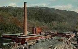
Cascade Mill c. 1920
USA New Hampshire location map.svg
Red pog.svg
Cascade
Usa edcp location map.svg
Red pog.svg
Cascade
Coordinates: 44°26′58″N71°11′33″W / 44.44944°N 71.19250°W / 44.44944; -71.19250 Coordinates: 44°26′58″N71°11′33″W / 44.44944°N 71.19250°W / 44.44944; -71.19250
Country United States
State New Hampshire
County Coos
City Berlin
Town Gorham
Elevation
1,047 ft (319 m)
Time zone UTC-5 (Eastern (EST))
  Summer (DST) UTC-4 (EDT)
Area code 603
GNIS feature ID871636 [1]

Cascade is an unincorporated community within the city of Berlin and the town of Gorham, New Hampshire, United States. The village gets its name from a nearby alpine waterfall,[ citation needed ] which is visible in the hills to the east. The village straddles New Hampshire Route 16, the main road into Berlin from the south. On the eastern side of the road, there is a paper finishing mill located on flatlands by the Androscoggin River known as "Cascade Flats". On the western side there is a hill known as "Cascade Hill".

Contents

History

In the mid-1800s, travelers were attracted by the beauty of the Alpine Cascades. At that time, the cascades were reached by a small wire suspension bridge and a little trail through a grove. [2] In 1904, construction of the Cascade Mill began by the Brown Company. Italian and Polish immigrants help build the mill and later settled around it. Unfinished paper products from the Berlin mill were brought to this mill by two GE 70-ton locomotives, [3] and from there the paper processes were finished. The mill is now Gorham Paper and Tissue, which is managed by Patriarch Partners. [4]

In 1988, archaeological digs discovered four prehistoric sites on the east side of the Androscoggin River in the area of Pulsifer Rips, a two-mile-long stretch of river below Cascade Dam. The sites include remains of a village and stone tool workshops. [5]

Related Research Articles

<span class="mw-page-title-main">Windham, Maine</span> Town in the state of Maine, United States

Windham is a town in Cumberland County, Maine, United States. The population was 18,434 at the 2020 census. It includes the villages of South Windham and North Windham. It is part of the Portland–South Portland–Biddeford, Maine Metropolitan Statistical Area.

<span class="mw-page-title-main">Berlin, New Hampshire</span> City in New Hampshire, United States

Berlin is a city along the Androscoggin River in Coös County in northern New Hampshire, United States. It is the northernmost city in New Hampshire. The population was 9,425 at the 2020 census, down from 10,051 at the 2010 census.

<span class="mw-page-title-main">Colebrook, New Hampshire</span> Town in New Hampshire, United States

Colebrook is a town in Coös County, New Hampshire, United States. The population was 2,084 at the time of the 2020 census, down from 2,301 at the 2010 census. Situated in the Great North Woods Region, it is bounded on the west by the Connecticut River and home to Beaver Brook Falls Natural Area.

<span class="mw-page-title-main">Groveton, New Hampshire</span> Census-designated place in New Hampshire, United States

Groveton is a census-designated place (CDP) and the primary village in the town of Northumberland in Coos County, New Hampshire, United States. The population was 1,068 at the 2020 census. It is located at the intersection of U.S. Route 3 and New Hampshire Route 110.

<span class="mw-page-title-main">Martin's Location, New Hampshire</span> Township in Coos County, New Hampshire, United States

Martin's Location is a township in Coös County, New Hampshire, United States. As of the 2020 census, two people were reported as living in the location. It lies entirely within the White Mountain National Forest, and is the site of the Dolly Copp Campground.

<span class="mw-page-title-main">Pinkham's Grant, New Hampshire</span> Township in Coos County, New Hampshire, United States

Pinkham's Grant is a township in Coös County, New Hampshire, United States. The grant lies entirely within the White Mountain National Forest. As of the 2020 United States census, the population of the grant was zero.

Gorham is a census-designated place (CDP) and the main village in the town of Gorham in Coos County, New Hampshire, United States. The population of the CDP was 1,851 at the 2020 census, out of 2,698 people in the entire town of Gorham.

<span class="mw-page-title-main">Success, New Hampshire</span> Township in Coos County, New Hampshire, United States

Success is an unincorporated township in Coös County, New Hampshire, United States. It is located directly to the east of the city of Berlin, and borders on the state of Maine. Success is part of the Berlin, NH–VT Micropolitan Statistical Area.

<span class="mw-page-title-main">St. Lawrence and Atlantic Railroad</span> Railroad in northern New England

The St. Lawrence and Atlantic Railroad, known as St-Laurent et Atlantique Quebec in Canada, is a short-line railway operating between Portland, Maine, on the Atlantic Ocean, and Montreal, Quebec, on the St. Lawrence River. It crosses the Canada–US border at Norton, Vermont, and Stanhope, Quebec, and is owned by short-line operator Genesee & Wyoming.

<span class="mw-page-title-main">Androscoggin River</span> River in New Hampshire and Maine, United States

The Androscoggin River is a river in the U.S. states of Maine and New Hampshire, in northern New England. It is 178 miles (286 km) long and joins the Kennebec River at Merrymeeting Bay in Maine before its water empties into the Gulf of Maine on the Atlantic Ocean. Its drainage basin is 3,530 square miles (9,100 km2) in area. The name "Androscoggin" comes from the Eastern Abenaki term /aləssíkɑntəkw/ or /alsíkɑntəkw/, meaning "river of cliff rock shelters" ; or perhaps from Penobscot /aləsstkɑtəkʷ/, meaning "river of rock shelters". The Anglicization of the Abenaki term is likely an analogical contamination with the colonial governor Edmund Andros.

<span class="mw-page-title-main">Wild River (Androscoggin River tributary)</span> River in New Hampshire and Maine, United States

The Wild River is a 17.2-mile-long (27.7 km) river in the White Mountains of New Hampshire and Maine in the United States. It is a tributary of the Androscoggin River, which flows east and south to the Kennebec River near the Atlantic Ocean.

<span class="mw-page-title-main">Dead River (New Hampshire)</span> River in New Hampshire, United States

The Dead River is a 3.5-mile-long (5.6 km) river located entirely within the city limits of Berlin, New Hampshire, in the United States. It is a tributary of the Androscoggin River, which flows south from Berlin before turning east at Gorham and into Maine, eventually joining the Kennebec River at Merrymeeting Bay. The Abenaki people called the Dead River Plumpetoosuc, which means "shallow, narrow river".

<span class="mw-page-title-main">Jericho Mountain State Park</span> State park in New Hampshire, United States

Jericho Mountain State Park is located in the White Mountains in Berlin, New Hampshire, United States. The park offers trail riding for ATV, UTV, trail bike, and snowmobile enthusiasts, as well as camping, swimming, fishing, canoeing, and picnicking at Jericho Lake.

<span class="mw-page-title-main">Presumpscot River</span> River in the United States of America

The Presumpscot River is a 25.8-mile-long (41.5 km) river located in Cumberland County, Maine. It is the main outlet of Sebago Lake. The river provided an early transportation corridor with reliable water power for industrial development of the city of Westbrook and the village of South Windham.

<span class="mw-page-title-main">U.S. Route 2 in New Hampshire</span> Section of Numbered Highway in Coos County, New Hampshire, United States

U.S. Route 2 (US 2) is a part of the United States Numbered Highway System that is split into two segments, one between Washington and Michigan and the other between New York and Maine. In New Hampshire, US 2 runs 35.437 miles (57.030 km) from the Vermont state line at the Connecticut River in Lancaster east to the Maine state line in Shelburne. US 2 is the main highway through the White Mountains across southern Coös County, where it also passes through Jefferson, Randolph, and Gorham. US 2 is the main connection between the Coös county seat of Lancaster, where the highway intersects US 3, and the county's largest city, Berlin, via its connection with New Hampshire Route 16 (NH 16) in Gorham.

<span class="mw-page-title-main">Brown Company</span>

The Brown Company, known as the Brown Corporation in Canada, was a pulp and papermaking company based in Berlin, New Hampshire, United States. They closed their doors during the 1980s.

<span class="mw-page-title-main">William E. Corbin</span>

William E. Corbin (1869–1951) was the inventor of Nibroc paper towels and was the mayor of the city of Berlin, New Hampshire (1931–1932).

<span class="mw-page-title-main">Gorham, New Hampshire</span> Town in New Hampshire, United States

Gorham is a town in Coös County, New Hampshire, United States. The population was 2,698 at the 2020 census. Gorham is located in the White Mountains, and parts of the White Mountain National Forest are in the south and northwest. Moose Brook State Park is in the west. Tourism is a principal business. It is part of the Berlin, NH–VT Micropolitan Statistical Area.

<span class="mw-page-title-main">Gorham station (Grand Trunk Railway)</span>

Gorham station is a former Grand Trunk Railway station in Gorham, New Hampshire, United States. It was built in 1907, long after the arrival of the railroad in 1851.

References

  1. "Cascade". Geographic Names Information System . United States Geological Survey, United States Department of the Interior.
  2. "History of Coos County, New Hampshire" . Retrieved July 17, 2012.
  3. "Berlin Mills Railway" (PDF). Retrieved July 17, 2012.
  4. "Gorham Paper and Tissue" . Retrieved July 14, 2012.
  5. U.S. Federal Energy Regulatory Commission (1993). "Upper Androscoggin River Basin Hydroelectric Project" . Retrieved March 17, 2017.