Jefferson Township, Franklin County, Ohio

Last updated

Jefferson Township, Franklin County, Ohio
Jefferson Township Administration Sign 1.jpg
Map of Franklin County, Ohio highlighting Jefferson Township.svg
Location of Jefferson Township in Franklin County.
Coordinates: 40°0′23″N82°48′32″W / 40.00639°N 82.80889°W / 40.00639; -82.80889
Country United States
State Ohio
County Franklin
Area
[1]
  Total15.1 sq mi (39 km2)
  Land14.9 sq mi (39 km2)
  Water0.2 sq mi (0.5 km2)
Elevation
[2]
948 ft (289 m)
Population
 (2020) [3]
  Total14,475
  Density960/sq mi (370/km2)
Time zone UTC-5 (Eastern (EST))
  Summer (DST) UTC-4 (EDT)
FIPS code 39-38612 [4]
GNIS feature ID1086106 [2]
Website Township website

Jefferson Township is situated on the northeast edge of Franklin County, Ohio as a part of the Columbus metropolitan area and situated between the Blacklick Creek, Big Walnut Creek and Swisher Creek watershed. The township is one of the seventeen townships of Franklin County, Ohio, United States. The 2020 census found 14,475 people in the township. It was established on September 6, 1816. [5]

Contents

Geography

Located in the eastern part of the county, Jefferson Township consists of a large section and many small "islands". Most of these islands are surrounded by either Gahanna or Columbus, cities that have annexed most of the western and southern parts of the township. The large section borders the following townships and cities:

Besides Gahanna and Columbus, the unincorporated community of Blacklick lies in the southern part of the township.

Blacklick Creek and its associated tributaries of its watershed such as Swisher Creek flow through Jefferson Township. Big Walnut Creek is also to the west of the township while some of its tributaries such as Rocky Fork Creek travel through the western part of Jefferson Township. This has caused the topography in the township to be more varied then some of the surrounding areas from the resulting from these stream corridors, hills, ravines, and slopes much of it associated with the waterways, tributaries, and floodplain that Jefferson Township is in from Rocky Fork, Blacklick, and Swisher Creeks [6]

Climate

The Köppen Climate Classification subtype for this climate is "Dfa" (Hot Summer Continental Climate). [7] This climate type is assessed as a Humid continental climate, which is a climatic region typified by large seasonal temperature differences, with warm to hot (and sometimes humid) summers and cold (sometimes severely cold) winters.

Name and history

The area of the Scioto River, Olentangy River watershed, south to the Ohio River area have been inhabited by the Adena people more than 2000 years ago. Two earthworks from mound builders cultures have been found in Jefferson Township and new ones continue to be found in the area around the township to this day. [6]

The first settlement in what became Jefferson Township by settlers of European descent was established in 1802 or 1803 [8] after beneficiaries of land grants for service in the Revolutionary War began to occupy and farm the area. [6] Jefferson Township was established on September 6, 1816. [5] In 1840, Jefferson Township contained 1,040 inhabitants. By 1850, it had only grown to 1,236. [8] It is one of twenty-four Jefferson Townships statewide. [9]

In 2003 Jefferson Township was granted Ohio Scenic Byway status by ODOT and the township actively manages and protects the historic character of the 15 miles of the Jefferson Township Scenic Byways corridor. The most recent management plan was done in 2015. [10]

Government

Municipal Building and Fire Department Headquarters Jefferson Township Fire Department HQ 1.jpg
Municipal Building and Fire Department Headquarters

The township is governed by a three-member board of trustees, who are elected in November of odd-numbered years to a four-year term beginning on the following January 1. Two are elected in the year after the presidential election and one is elected in the year before it. There is also an elected township fiscal officer, [11] who serves a four-year term beginning on April 1 of the year after the election, which is held in November of the year before the presidential election. Vacancies in the fiscal officership or on the board of trustees are filled by the remaining trustees.

Jefferson Township established its own Water and Sewer district independent of Franklin County, Columbus or Gahanna, unlike most townships locally. [12] Jefferson Water and Sewer District or JWSD was created in 1987. [13]

The majority of the township is in the Gahanna-Jefferson Public School District with some additional parts in the boundaries of Columbus, Licking Heights, and Reynoldsburg Unified School Districts as well. [14]

Jefferson Township is split between the US Congressional Districts: OH-3, OH-12. It is in Ohio's 3rd senatorial district, and its Ohio State House Districts are OH-19 and OH-20. [14]

Related Research Articles

<span class="mw-page-title-main">Franklin County, Ohio</span> County in Ohio, United States

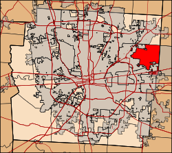
Franklin County is a county in the U.S. state of Ohio. As of the 2020 census, the population was 1,323,807, making it the most populous county in Ohio. Most of its land area is taken up by its county seat, Columbus, the state capital and most populous city in Ohio. The county was established on April 30, 1803, less than two months after Ohio became a state, and was named after Benjamin Franklin. Originally, Franklin County extended north to Lake Erie before it was subdivided into smaller counties. Franklin County is the central county of the Columbus, Ohio Metropolitan Statistical Area.

<span class="mw-page-title-main">Fairfield County, Ohio</span> County in Ohio, US

Fairfield County is a county located in the U.S. state of Ohio. As of the 2020 census, the population was 158,921. Its county seat and largest city is Lancaster. Its name is a reference to the Fairfield area of the original Lancaster.

<span class="mw-page-title-main">Gahanna, Ohio</span> City in Ohio, United States

Gahanna is a city situated in northeast Franklin County, Ohio, United States. It is a suburb of Columbus. The population was 35,726 at the 2020 census. It was founded in 1849.

<span class="mw-page-title-main">New Albany, Ohio</span> City in Ohio, United States

New Albany is a city in the U.S. state of Ohio, located 15 miles (24 km) northeast of the state capital of Columbus. Most of the city is located in Franklin County and a small portion extends into adjacent Licking County. New Albany had a population of 10,825 at the 2020 census. Founded in 1837, it is a growing suburb in the Columbus metropolitan area.

<span class="mw-page-title-main">Pataskala, Ohio</span> City in Ohio, United States

Pataskala is a city in Licking County, Ohio, United States, approximately 19 miles (31 km) east of Columbus. The population was 17,886 at the 2020 census. Pataskala was a small community until 1996, when what was then the village of Pataskala merged with Lima Township, vastly increasing its population and geographic area.

<span class="mw-page-title-main">Reynoldsburg, Ohio</span> City in Ohio, United States

Reynoldsburg is a city in Fairfield, Franklin, and Licking counties in the U.S. state of Ohio. It is a suburban community in the Columbus, Ohio metropolitan area. The population was 41,076 at the 2020 census.

<span class="mw-page-title-main">Blacklick Creek (Ohio)</span> River

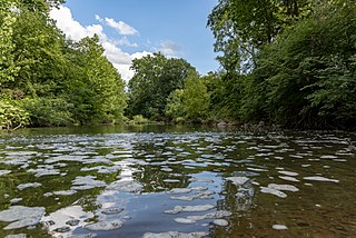
Blacklick Creek is a tributary stream of Big Walnut Creek in Ohio, flowing through Licking, Fairfield and Franklin counties. The creek's name was originally given by Native Americans, who had noticed the animals that frequented the creek to lick its black-colored salt stones. It has also been known as Black Lick Creek, Black Lick Fork, Blacks Lick Creek, and Big Lick Creek.

<span class="mw-page-title-main">Blacklick, Ohio</span> Unincorporated community in Ohio, United States

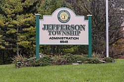
Blacklick is a small unincorporated community in southern Jefferson Township, Franklin County, Ohio, United States. Blacklick is also included in the Columbus Metropolitan area.

Reynoldsburg High School (RHS) is a public high school located in Reynoldsburg, Ohio, United States, and the only high school in the Reynoldsburg City School District. The school is divided into five academies housed at two separate campuses, each of which has its own academy leaders and administrative team. The athletic teams are known as the Reynoldsburg Raiders, and the school colors are purple and gold. Reynoldsburg High School was established in 1870. The Livingston Campus opened in 1961, followed by the Summit Campus in 2011.

<span class="mw-page-title-main">Big Walnut Creek</span> River

Big Walnut Creek starts near Mount Gilead, Ohio in Morrow County. It flows south to eastern Delaware County and parallels Alum Creek. It passes to the east of Sunbury and into Hoover Reservoir, which then crosses into Franklin County. From the dam outflow in Westerville the creek flows through Gahanna and Whitehall. Near Obetz it is joined by its principal tributaries Alum Creek and Blacklick Creek at the Three Creeks Columbus Metro Park. It flows through southern Franklin County and joins the Scioto River near the Franklin-Pickaway Counties line at 39°47′57″N83°00′34″W.

<span class="mw-page-title-main">Plain Township, Franklin County, Ohio</span> Township in Ohio, United States

Plain Township is one of the seventeen townships of Franklin County, Ohio, United States. As of the 2020 census the population was 12,761.

<span class="mw-page-title-main">Jersey Township, Licking County, Ohio</span> Township in Ohio, United States

Jersey Township is one of the 25 townships of Licking County, Ohio, United States. As of the 2020 census, the population was 2,557.

<span class="mw-page-title-main">Mifflin Township, Franklin County, Ohio</span> Township in Ohio, United States

Mifflin Township is one of the seventeen townships of Franklin County, Ohio, United States. The 2020 census found 38,368 people in the township.

<span class="mw-page-title-main">Violet Township, Fairfield County, Ohio</span> Township in Ohio, United States

Violet Township is one of the thirteen townships of Fairfield County, Ohio, United States. As of the 2020 census the population was 45,785, up from 38,572 people at the 2010 census. It is the only Township in Fairfield County that is classified as an Urban township.

<span class="mw-page-title-main">Madison Township, Franklin County, Ohio</span> Township in Ohio, United States

Madison Township is one of the seventeen townships of Franklin County, Ohio, United States. The 2020 census found 25,945 people in the township.

<span class="mw-page-title-main">Truro Township, Franklin County, Ohio</span> Township in Ohio, United States

Truro Township is one of the seventeen townships of Franklin County, Ohio, United States. The 2020 census found 30,401 people in the township.

<span class="mw-page-title-main">Brownsville, Ohio</span> Census-designated place in Ohio, United States

Brownsville is an unincorporated community and census-designated place (CDP) in northeastern Bowling Green Township, Licking County, Ohio, United States. As of the 2020 census, it had a population of 214. It lies at the intersection of U.S. Route 40 with State Route 668.

<span class="mw-page-title-main">Etna, Licking County, Ohio</span> Census-designated place in Ohio, United States

Etna is an unincorporated community and census-designated place (CDP) in Licking County, Ohio, United States. As of the 2020 census it had a population of 1,209. It lies at an elevation of 1,069 feet (326 m) at the intersection of U.S. Route 40 and State Route 310. It was listed as a census-designated place in 2010.

<span class="mw-page-title-main">Etna Township, Ohio</span> Township in Ohio, United States

Etna Township is one of the 25 townships of Licking County, Ohio, United States. As of the 2020 census, the population was 18,896.

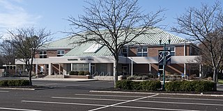
Gahanna-Jefferson Public Schools is a school district headquartered in Gahanna, Ohio, in the Columbus, Ohio metropolitan area.

References

  1. "2010 Census U.S. Gazetteer Files for County Subdivisions". U.S. Census Bureau, Geography Division. February 2, 2011. Archived from the original on April 9, 2011. Retrieved February 18, 2012.
  2. 1 2 "US Board on Geographic Names". United States Geological Survey. October 25, 2007. Retrieved January 31, 2008.
  3. "Jefferson township, Franklin County, Ohio - Census Bureau Profile". United States Census Bureau. Retrieved July 1, 2023.
  4. "U.S. Census website". United States Census Bureau . Retrieved January 31, 2008.
  5. 1 2 "Franklin County Genealogical & Historical Society –Township Histories".
  6. 1 2 3 "Archived copy" (PDF). Archived from the original (PDF) on August 20, 2016. Retrieved October 26, 2017.{{cite web}}: CS1 maint: archived copy as title (link)
  7. Climate Summary for Blacklick, Ohio
  8. 1 2 "Franklin County, Ohio History –A collection of Reminiscences of the Early Settlement of the county".
  9. "Detailed map of Ohio" (PDF). United States Census Bureau. 2000. Retrieved February 16, 2007.
  10. https://www.dot.state.oh.us/OhioByways/Documents/CMPs/Jefferson%20Township%20Scenic%20Byways%202015%20CMP%20Update.pdf [ bare URL PDF ]
  11. §503.24, §505.01, and §507.01 of the Ohio Revised Code. Accessed 4/30/2009.
  12. http://www.dispatch.com/content/stories/local/2012/04/02/township-has-growing-pains.html Archived 2017-10-26 at the Wayback Machine [ bare URL ]
  13. "Jefferson Township > Additional Services > Jefferson Water and Sewer District". Archived from the original on October 26, 2017. Retrieved October 25, 2017.
  14. 1 2 "The Demographic Statistical Atlas of the United States –Statistical Atlas".