Joint precision approach and landing system

Last updated
LAAS architecture, similar in concept to JPALS LDGPS fixed base category LAAS Architecture.svg
LAAS architecture, similar in concept to JPALS LDGPS fixed base category

The joint precision approach and landing system (JPALS) is a ship's system (CVN and LH type), all-weather landing system based on real-time differential correction of the Global Positioning System (GPS) signal, augmented with a local area correction message, and transmitted to the user via secure means. The onboard receiver compares the current GPS-derived position with the local correction signal, deriving a highly accurate three-dimensional position capable of being used for all-weather approaches via an Instrument Landing System-style display. While JPALS is similar to Local Area Augmentation System, but intended primarily for use by the military, some elements of JPALS may eventually see their way into civilian use to help protect high-value civilian operations against unauthorized signal alteration.

Contents

History

JPALS tactical prototype JPALS Tactical Prototype.jpg
JPALS tactical prototype

The development of JPALS was the result of two main military requirements. First, the military needs an all-service, highly mobile all-weather precision approach system, tailorable to a wide range of environments, from shipboard use to rapid installation at makeshift airfields. Second, they need a robust system that can maintain a high level of reliability in combat operations, particularly in its ability to effectively resist jamming.

Operation

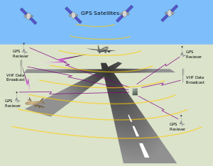
JPALS encompasses two main categories: SRGPS (shipboard relative GPS) and LDGPS (land/local differential GPS). SRGPS provides highly accurate approach positioning for operations aboard ship, including aircraft carriers, helo and STO/VL carriers, and other shipboard operations, primarily helicopter operations.

LDGPS is further divided into three sub-categories: fixed base, tactical, and special missions. Fixed base is used for ongoing operations at military airfields around the world, while the tactical system is portable, designed for relatively short-term, austere airfield operations. The special missions system is a highly portable system capable of rapid installation and use by special forces.

Accuracy

The accuracy of local area augmentation system (LAAS) is better than CAT III ILS accuracy, and will provide horizontal and vertical resolutions of less than 1 m. Although the exact accuracy of JPALS will remain classified, it's estimated that JPALS will meet or exceed this accuracy for authorized users.

Benefits

The main benefit of JPALS is that it's a system that can be taken anywhere, anytime, providing a safe and effective way to conduct 24/7, all-weather, anti-jam instrument landing system capability to all authorized users, worldwide. A secondary benefit is a significant reduction in cost over current systems.

The naval version of JPALS transmits a signal that has a low probability of intercept; so it is unlikely that an enemy will detect the signal and trace it back to its source. The existing system, tactical air navigation (TACAN), is not encrypted or concealed in any way, which can reveal the location of the ship on which it is installed. This is not acceptable in emissions control (EMCON) or stealth conditions.

The increase in both accuracy and reliability will significantly enhance operations while reducing non-operational periods due to weather or adversarial efforts.

See also

Related Research Articles

<span class="mw-page-title-main">Radio navigation</span> Use of radio-frequency electromagnetic waves to determine position on the Earths surface

Radio navigation or radionavigation is the application of radio frequencies to determine a position of an object on the Earth, either the vessel or an obstruction. Like radiolocation, it is a type of radiodetermination.

<span class="mw-page-title-main">European Geostationary Navigation Overlay Service</span> System that enhances the accuracy of GPS receivers

The European Geostationary Navigation Overlay Service (EGNOS) is a satellite-based augmentation system (SBAS) developed by the European Space Agency and EUROCONTROL on behalf of the European Commission. Currently, it supplements the GPS by reporting on the reliability and accuracy of their positioning data and sending out corrections. The system will supplement Galileo in a future version.

<span class="mw-page-title-main">Instrument landing system</span> Ground-based visual aid for landing

In aviation, the instrument landing system (ILS) is a precision radio navigation system that provides short-range guidance to aircraft to allow them to approach a runway at night or in bad weather. In its original form, it allows an aircraft to approach until it is 200 feet (61 m) over the ground, within a 12 mile (800 m) of the runway. At that point the runway should be visible to the pilot; if it is not, they perform a missed approach. Bringing the aircraft this close to the runway dramatically increases the range of weather conditions in which a safe landing can be made. Other versions of the system, or "categories", have further reduced the minimum altitudes, runway visual ranges (RVRs), and transmitter and monitoring configurations designed depending on the normal expected weather patterns and airport safety requirements.

The basic principles of air navigation are identical to general navigation, which includes the process of planning, recording, and controlling the movement of a craft from one place to another.

<span class="mw-page-title-main">Wide Area Augmentation System</span> System that enhances the accuracy of GPS receivers

The Wide Area Augmentation System (WAAS) is an air navigation aid developed by the Federal Aviation Administration to augment the Global Positioning System (GPS), with the goal of improving its accuracy, integrity, and availability. Essentially, WAAS is intended to enable aircraft to rely on GPS for all phases of flight, including precision approaches to any airport within its coverage area. It may be further enhanced with the Local Area Augmentation System (LAAS) also known by the preferred ICAO term Ground-Based Augmentation System (GBAS) in critical areas.

<span class="mw-page-title-main">Tactical air navigation system</span> Military navigation system

A tactical air navigation system, commonly referred to by the acronym TACAN, is a navigation system used by military aircraft. It provides the user with bearing and distance to a ground or ship-borne station. It is a more accurate version of the VOR/DME system that provides bearing and range information for civil aviation. The DME portion of the TACAN system is available for civil use; at VORTAC facilities where a VOR is combined with a TACAN, civil aircraft can receive VOR/DME readings. Aircraft equipped with TACAN avionics can use this system for en route navigation as well as non-precision approaches to landing fields. The Space Shuttle is one such vehicle that was designed to use TACAN navigation but later upgraded with GPS as a replacement.

<span class="mw-page-title-main">Satellite navigation</span> Use of satellite signals for geo-spatial positioning

A satellite navigation or satnav system is a system that uses satellites to provide autonomous geo-spatial positioning. It allows satellite navigation devices to determine their location to high precision using time signals transmitted along a line of sight by radio from satellites. The system can be used for providing position, navigation or for tracking the position of something fitted with a receiver. The signals also allow the electronic receiver to calculate the current local time to a high precision, which allows time synchronisation. These uses are collectively known as Positioning, Navigation and Timing (PNT). Satnav systems operate independently of any telephonic or internet reception, though these technologies can enhance the usefulness of the positioning information generated.

<span class="mw-page-title-main">Instrument approach</span> Aircraft landing procedure

In aviation, an instrument approach or instrument approach procedure (IAP) is a series of predetermined maneuvers for the orderly transfer of an aircraft operating under instrument flight rules from the beginning of the initial approach to a landing, or to a point from which a landing may be made visually. These approaches are approved in the European Union by EASA and the respective country authorities and in the United States by the FAA or the United States Department of Defense for the military. The ICAO defines an instrument approach as, "a series of predetermined maneuvers by reference to flight instruments with specific protection from obstacles from the initial approach fix, or where applicable, from the beginning of a defined arrival route to a point from which a landing can be completed and thereafter, if landing is not completed, to a position at which holding or en route obstacle clearance criteria apply."

<span class="mw-page-title-main">Differential GPS</span> Enhancement to the Global Positioning System providing improved accuracy

Differential Global Positioning Systems (DGPSs) supplement and enhance the positional data available from global navigation satellite systems (GNSSs). A DGPS for GPS can increase accuracy by about a thousandfold, from approximately 15 metres (49 ft) to 1–3 centimetres.

<span class="mw-page-title-main">Microwave landing system</span> All-weather, precision radio guidance system

The microwave landing system (MLS) is an all-weather, precision radio guidance system intended to be installed at large airports to assist aircraft in landing, including 'blind landings'. MLS enables an approaching aircraft to determine when it is aligned with the destination runway and on the correct glidepath for a safe landing. MLS was intended to replace or supplement the instrument landing systems (ILS). MLS has a number of operational advantages over ILS, including a wider selection of channels to avoid interference with nearby installations, excellent performance in all weather, a small "footprint" at the airports, and wide vertical and horizontal "capture" angles that allowed approaches from wider areas around the airport.

<span class="mw-page-title-main">Local-area augmentation system</span> All-weather aircraft landing system

The local-area augmentation system (LAAS) is an all-weather aircraft landing system based on real-time differential correction of the GPS signal. Local reference receivers located around the airport send data to a central location at the airport. This data is used to formulate a correction message, which is then transmitted to users via a VHF Data Link. A receiver on an aircraft uses this information to correct GPS signals, which then provides a standard ILS-style display to use while flying a precision approach. The FAA has stopped using the term LAAS and has transitioned to the International Civil Aviation Organization (ICAO) terminology of Ground-Based Augmentation System (GBAS). While the FAA has indefinitely delayed plans for federal GBAS acquisition, the system can be purchased by airports and installed as a Non-Federal navigation aid.

<span class="mw-page-title-main">Transponder landing system</span> All-weather, precision landing system

A transponder landing system (TLS) is an all-weather, precision landing system that uses existing airborne transponder and instrument landing system (ILS) equipment to create a precision approach at a location where an ILS would normally not be available.

StarFire is a wide-area differential GPS developed by John Deere's NavCom and precision farming groups. StarFire broadcasts additional "correction information" over satellite L-band frequencies around the world, allowing a StarFire-equipped receiver to produce position measurements accurate to well under one meter, with typical accuracy over a 24-hour period being under 4.5 cm. StarFire is similar to the FAA's differential GPS Wide Area Augmentation System (WAAS), but considerably more accurate due to a number of techniques that improve its receiver-end processing.

The GPS-aided GEO augmented navigation (GAGAN) is an implementation of a regional satellite-based augmentation system (SBAS) by the Government of India. It is a system to improve the accuracy of a GNSS receiver by providing reference signals. The Airports Authority of India (AAI)'s efforts towards implementation of operational SBAS can be viewed as the first step towards introduction of modern communication, navigation and surveillance / air traffic management system over the Indian airspace.

<span class="mw-page-title-main">GNSS augmentation</span> Method of improving a navigation system

Augmentation of a global navigation satellite system (GNSS) is a method of improving the navigation system's attributes, such as precision, reliability, and availability, through the integration of external information into the calculation process. There are many such systems in place, and they are generally named or described based on how the GNSS sensor receives the external information. Some systems transmit additional information about sources of error, others provide direct measurements of how much the signal was off in the past, while a third group provides additional vehicle information to be integrated in the calculation process.

In aviation a ground-controlled approach (GCA), is a type of service provided by air-traffic controllers whereby they guide aircraft to a safe landing, including in adverse weather conditions, based on primary radar images. Most commonly, a GCA uses information from either a precision approach radar or an airport surveillance radar. The term GCA may refer to any type of ground radar guided approach such as a PAR, PAR without glideslope or ASR. When both vertical and horizontal guidance from the PAR is given, the approach is termed a precision approach. If no PAR glidepath is given, even if PAR equipment is used for lateral guidance, it is considered a non-precision approach.

Global Navigation Satellite System (GNSS) receivers, using the GPS, GLONASS, Galileo or BeiDou system, are used in many applications. The first systems were developed in the 20th century, mainly to help military personnel find their way, but location awareness soon found many civilian applications.

Localizer performance with vertical guidance (LPV) are the highest precision GPS aviation instrument approach procedures currently available without specialized aircrew training requirements, such as required navigation performance (RNP). Landing minima are usually similar to those of a Cat I instrument landing system (ILS), that is, a decision height of 200 feet (61 m) and visibility of 800 m. Lateral guidance is equivalent to a localizer, and uses a ground-independent electronic glide path. Thus, the decision altitude, DA, can be as low as 200 feet. An LPV approach is an approach with vertical guidance, APV, to distinguish it from a precision approach, PA, or a non-precision approach, NPA. WAAS criteria includes a vertical alarm limit more than 12 m, but less than 50 m, yet an LPV does not meet the ICAO Annex 10 precision approach standard.

<span class="mw-page-title-main">Error analysis for the Global Positioning System</span> Detail of the global positioning system

The error analysis for the Global Positioning System is important for understanding how GPS works, and for knowing what magnitude of error should be expected. The GPS makes corrections for receiver clock errors and other effects but there are still residual errors which are not corrected. GPS receiver position is computed based on data received from the satellites. Errors depend on geometric dilution of precision and the sources listed in the table below.

<span class="mw-page-title-main">Enhanced flight vision system</span>

An enhanced flight vision system is an airborne system which provides an image of the scene and displays it to the pilot, in order to provide an image in which the scene and objects in it can be better detected. In other words, an EFVS is a system which provides the pilot with an image which is better than unaided human vision. An EFVS includes imaging sensors such as a color camera, infrared camera or radar, and typically a display for the pilot, which can be a head-mounted display or head-up display. An EFVS may be combined with a synthetic vision system to create a combined vision system.

References