
Armstrong County is a county located in the U.S. state of Pennsylvania. As of the 2010 census, the population was 68,941. The county seat is Kittanning. The county was organized on March 12, 1800, from parts of Allegheny, Westmoreland and Lycoming Counties. It was named in honor of John Armstrong, who represented Pennsylvania in the Continental Congress and served as a major general during the Revolutionary War.
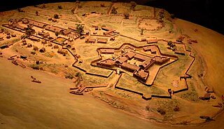
Fort Duquesne was a fort established by the French in 1754, at the confluence of the Allegheny and Monongahela rivers. It was later taken over by the British, and later Americans, and developed as Pittsburgh in the U.S. state of Pennsylvania. Fort Duquesne was destroyed by the French, prior to British conquest during the Seven Years' War, known as the French and Indian War on the North American front. The latter replaced it, building Fort Pitt between 1759 and 1761. The site of both forts is now occupied by Point State Park, where the outlines of the two forts have been laid in brick.
Fayette County is a county of the U.S. state of Pennsylvania. Fayette County is located in southwestern Pennsylvania, adjacent to Maryland and West Virginia. As of the 2010 census, the population was 136,606. Its county seat is Uniontown. The county was created on September 26, 1783, from part of Westmoreland County and named after the Marquis de Lafayette.

Dunbar is a borough in Fayette County, Pennsylvania, United States. The population was 1,042 at the 2010 census, down from 1,219 at the 2000 census.
Hopwood is a census-designated place (CDP) in Fayette County, Pennsylvania, United States. The population was 2,090 at the 2010 census, up from 2,006 at the 2000 census. It is located in North Union and South Union townships. The village was named after John Hopwood.
North Union Township is a township in Fayette County, Pennsylvania, United States. The population was 12,728 at the 2010 census, down from 14,140 at the 2000 census. The Laurel Highlands School District serves the township.

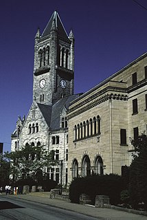
Uniontown is a city in Fayette County, Pennsylvania, United States, 46 miles (74 km) southeast of Pittsburgh and part of the Greater Pittsburgh Region. The population was 10,372 at the 2010 census, down from 12,422 at the 2000 census. It is the county seat and largest city of Fayette County.

Wharton Township is a township in Fayette County, Pennsylvania, United States. The population was 3,575 at the 2010 census, down from 4,145 at the 2000 census. The Uniontown Area School District serves the region.

Ridgeley is a town in Mineral County, West Virginia, United States, and part of the Cumberland Metropolitan Statistical Area. The population was 675 at the 2010 census.
Tanacharison, also called Tanaghrisson, was a Native American leader who played a pivotal role in the beginning of the French and Indian War. He was known to European-Americans as the Half-King, a title also used to describe several other historically important Native American leaders. His name has been spelled in a variety of ways.

The Battle of Fort Necessity took place on July 3, 1754, in what is now Farmington in Fayette County, Pennsylvania. The engagement, along with the May 28 skirmish known as the Battle of Jumonville Glen, was George Washington's first military experience and the only surrender of his military career. The Battle of Fort Necessity began the French and Indian War, which later spiraled into the global conflict known as the Seven Years' War.
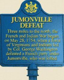
Joseph Coulon de Villiers, Sieur de Jumonville was a French Canadian military officer. His defeat and killing at the Battle of Jumonville Glen by forces led by George Washington was one of the sparks that ignited the Seven Years' War, known as the French and Indian War on the North American front.

The Battle of the Monongahela took place on 9 July 1755, at the beginning of the French and Indian War, at Braddock's Field in what is now Braddock, Pennsylvania, 10 miles (16 km) east of Pittsburgh. A British force under General Edward Braddock, moving to take Fort Duquesne, was defeated by a force of French and Canadian troops under Captain Daniel Liénard de Beaujeu with its American Indian allies.

The Battle of Jumonville Glen, also known as the Jumonville affair, was the opening battle of the French and Indian War, fought on May 28, 1754, near present-day Hopwood and Uniontown in Fayette County, Pennsylvania. A company of colonial militia from Virginia under the command of Lieutenant Colonel George Washington, and a small number of Mingo warriors led by Tanacharison, ambushed a force of 35 Canadiens under the command of Joseph Coulon de Villiers de Jumonville.

Fort Necessity National Battlefield is a National Battlefield in Fayette County, Pennsylvania, United States, which preserves the site of the Battle of Fort Necessity. The battle, which took place on July 3, 1754, was an early battle of the French and Indian War, and resulted in the surrender of British colonial forces under Colonel George Washington, to the French and Indians, under Louis Coulon de Villiers.
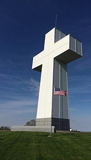
Bald Knob Cross, officially known as the Bald Knob Cross of Peace, is a large white cross located in Alto Pass, Illinois, United States. The structure is 111 feet (34 m) tall. The base of the cross is 1,034 feet above sea level and overlooks the Shawnee National Forest. Originally completed in 1963, the cross itself stands 111 feet tall, is 22 feet square at the base, 16 feet square at the top and its arms extend 63 feet horizontally. The exterior white panels covering the cross are 4-inch architectural flat insulated metal panels while the base portion is covered in granite approximately 4-inches thick. The structure sits on a foundation of 730 tons of reinforced concrete that goes down 20 feet to bedrock. The steel framework weighs approximately 170 tons. Each of the four sides of the cross have a word inscribed into the granite: Peace, Hope, Faith, Charity.

"Indian Reserve" is a historical term for the largely uncolonized land in North America that was claimed by France, ceded to Great Britain through the Treaty of Paris (1763) at the end of the Seven Years' War—also known as the French and Indian War—and set aside for the First Nations in the Royal Proclamation of 1763. The British government had contemplated establishing an Indian barrier state in the portion of the reserve west of the Appalachian Mountains, and bounded by the Ohio and Mississippi rivers and the Great Lakes. British officials aspired to establish such a state even after the region was assigned to the United States in the Treaty of Paris (1783) ending the American Revolutionary War, but abandoned their efforts in 1814 after losing military control of the region during the War of 1812.
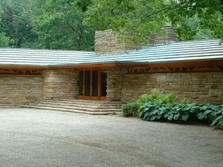
Kentuck Knob, also known as the Hagan House, is a house designed by the American architect Frank Lloyd Wright in rural Stewart Township near the village of Chalk Hill, Fayette County, Pennsylvania, USA, 45 miles (72 km) southeast of Pittsburgh. It was designated a National Historic Landmark in 2000 for the quality of its architecture.

Joseph Pasquale Pollia was an Italian-born American sculptor who created numerous monuments and war memorials.
Jumonville is a United Methodist camp and retreat center located in Fayette County, Pennsylvania near Uniontown, PA.
