The Storm Prediction Center (SPC) is a US government agency that is part of the National Centers for Environmental Prediction (NCEP), operating under the control of the National Weather Service (NWS), which in turn is part of the National Oceanic and Atmospheric Administration (NOAA) of the United States Department of Commerce (DoC).
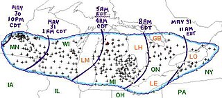
The Late-May 1998 tornado outbreak and derecho was a historic tornado outbreak and derecho that began on the afternoon of May 30 and extended throughout May 31, 1998, across a large portion of the northern half of the United States and southern Ontario from southeastern Montana east and southeastward to the Atlantic Ocean. The initial tornado outbreak, including the devastating Spencer tornado, hit southeast South Dakota on the evening of May 30. The Spencer tornado was the most destructive and the second-deadliest tornado in South Dakota history. A total of 13 people were killed; 7 by tornadoes and 6 by the derecho. Over two million people lost electrical power, some for up to 10 days.

This page documents notable tornadoes and tornado outbreaks worldwide in 2006. Strong and destructive tornadoes form most frequently in the United States, Bangladesh, and Eastern India, but they can occur almost anywhere under the right conditions. Tornadoes also develop occasionally in southern Canada during the Northern Hemisphere's summer and somewhat regularly at other times of the year across Europe, Asia, Argentina, Brazil and Australia. Tornadic events are often accompanied with other forms of severe weather, including strong thunderstorms, strong winds, and hail.

This page documents the tornadoes and tornado outbreaks that occurred in 2007, primarily in the United States. Most tornadoes form in the U.S., although some events may take place internationally, particularly in parts of neighboring southern Canada during the summer season. Some tornadoes also take place in Europe, e. g. in the United Kingdom or in Germany.
In weather forecasting in the United States, "particularly dangerous situation" (PDS) is enhanced wording used by the National Weather Service to convey special urgency in some watch or warning messages for unusually extreme and life-threatening severe weather events, above and beyond the average severity for the type of event. It is used in the format "This is a particularly dangerous situation..." at the discretion of the issuing forecaster. A watch or warning bearing the phrase is referred to as a PDS watch or PDS warning as shorthand jargon.
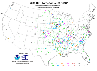
This page documents notable tornadoes and tornado outbreaks worldwide in 2008. Strong and destructive tornadoes form most frequently in the United States, Bangladesh, and Eastern India, but they can occur almost anywhere under the right conditions. Tornadoes also develop occasionally in southern Canada during the Northern Hemisphere's summer and somewhat regularly at other times of the year across Europe, Asia, and Australia. Tornadic events are often accompanied with other forms of severe weather, including strong thunderstorms, strong winds, and hail.
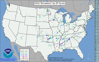
This page documents the tornadoes and tornado outbreaks of 2010. The majority of tornadoes form in the U.S., but they can occur almost anywhere under the right conditions. A lesser number occur outside the U.S., most notably in parts of neighboring southern Canada during the Northern Hemisphere's summer season, but are also known in South America, Europe, Asia, and Australia.

The June 2010 Northern Plains tornado outbreak was one of the most prolific summer tornado outbreaks in the Northern Great Plains of the United States on record. The outbreak began on June 16, with several tornadoes in South Dakota and Montana. The most intense storms took place the following day across much of eastern North Dakota and much of Minnesota. The system produced 93 tornadoes reported across four states while killing three people in Minnesota. Four of the tornadoes were rated as EF4 on the Enhanced Fujita scale, the most violent tornadoes in a 24-hour period since there were five within 15 hours in the 2008 Super Tuesday tornado outbreak. This was the region's first major tornado outbreak of the year and one of the largest on record in the region, comparable to a similar outbreak in June 1992. The 48 tornadoes that touched down in Minnesota on June 17 marked the most active single day in the state's history. June 17 was the second largest tornado day on record in the meteorological summer, behind the most prolific day of the 2003 South Dakota tornado outbreak on June 24, 2003.
During the summer of 2012, a series of severe wind events associated with powerful thunderstorms, known as derechos, affected widespread areas of the United States. The first of these derechos occurred in late June, and caused power outages that affected nearly five million people. Three weaker derechos occurred in July, and a final derecho disrupted activities in Chicago, Illinois in early August. Only three tornadoes were reported in conjunction with the derechos.

This page documents notable tornadoes and tornado outbreaks worldwide in 2020. Strong and destructive tornadoes form most frequently in the United States, Argentina, Brazil, Bangladesh, and eastern India, but can occur almost anywhere under the right conditions. Tornadoes also develop occasionally in southern Canada during the Northern Hemisphere's summer and somewhat regularly at other times of the year across Europe, Asia, Argentina, Australia and New Zealand. Tornadic events are often accompanied by other forms of severe weather, including strong thunderstorms, strong winds, and hail. There were 1,243 preliminary filtered reported tornadoes in 2020 in the United States in 2020, and 1,086 confirmed tornadoes in the United States in 2020. Worldwide, at least 93 tornado-related deaths were confirmed with 78 in the United States, eight in Vietnam, two each in Canada, Indonesia, and Mexico, and one in South Africa.

The August 2020 Midwest derecho was a powerful derecho affecting the Midwestern United States on August 10–11, 2020, primarily eastern Nebraska, Iowa, Illinois, Wisconsin, and Indiana. It caused high winds and spawned an outbreak of weak tornadoes. Some areas reported torrential rain and large hail.

Hurricane Zeta was a late-season major hurricane in 2020 that made landfall on the Yucatán Peninsula and then in southeastern Louisiana, the latest on record to do so at such strength in the United States. Zeta was the record-tying sixth hurricane of the year to make landfall in the United States. The twenty-seventh named storm, twelfth hurricane and fifth major hurricane of the extremely active 2020 Atlantic hurricane season, Zeta formed from a broad area of low pressure that formed in the western Caribbean Sea on October 19. After battling wind shear, the quasi-stationary low organized into Tropical Depression Twenty-Eight on October 24. The system strengthened into Tropical Storm Zeta early on October 25 before becoming a hurricane the next day as it began to move northwestward. Hurricane Zeta made landfall on the Yucatán Peninsula late on October 26 and weakened while inland to a tropical storm, before moving off the northern coast of the peninsula on October 27. After weakening due to dry air entrainment, Zeta reorganized and became a hurricane again, and eventually a Category 2 hurricane, as it turned northeastward approaching the United States Gulf Coast on October 28. It continued to strengthen until it reached its peak intensity as a major Category 3 hurricane with 115-mile-per-hour (185 km/h) sustained winds and a minimum pressure of 970 mbar (28.64 inHg) as it made landfall at Cocodrie, Louisiana, that evening. Zeta continued on through Mississippi and parts of Alabama with hurricane-force winds. Zeta gradually weakened as it accelerated northeastward, and became post-tropical on October 29, as it moved through central Virginia, dissipating shortly afterwards off the coast of New Jersey. After bringing accumulating snow to parts of New England, the extratropical low-pressure system carrying Zeta's remnant energy impacted the United Kingdom on November 1 and 2.

The March 2021 North American blizzard was a record-breaking blizzard in the Rocky Mountains and a significant snowstorm in the Upper Midwest that occurred in mid-March 2021. It brought Cheyenne, Wyoming their largest two-day snowfall on record, and Denver, Colorado their second-largest March snowfall on record. The storm originated from an extratropical cyclone in the northern Pacific Ocean in early March, arriving on the west coast of the United States by March 10. The storm moved into the Rocky Mountains on Saturday, March 13, dumping up to 2–3 feet (61–91 cm) of snow in some areas. It was unofficially given the name Winter Storm Xylia.
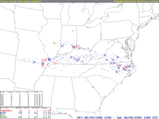
On June 4, 1993, a severe derecho swept across the Midwestern and Eastern United States. The most significant damage was reported in portions of southern Virginia, especially Lynchburg. This derecho caused widespread wind damage reports in a swath from Missouri eastward into much of Kentucky into Virginia and North Carolina. In addition, several severe wind reports were received scattered across this swath. In addition, there were a few weak tornadoes that were confirmed along the path. In addition, widespread large and damaging hail was observed along the path.
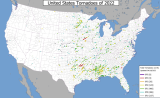
This page documents notable tornadoes and tornado outbreaks worldwide in 2022. Strong and destructive tornadoes form most frequently in the United States, Argentina, Brazil, Bangladesh, and Eastern India, but can occur almost anywhere under the right conditions. Tornadoes also develop occasionally in southern Canada during the Northern Hemisphere's summer and somewhat regularly at other times of the year across Europe, Asia, Argentina, Australia and New Zealand. Tornadic events are often accompanied by other forms of severe weather, including strong thunderstorms, strong winds, and hail. Worldwide, 32 tornado-related deaths were confirmed: 23 in the United States, three in China, two each in Poland and Russia, and one each in the Netherlands and Ukraine.

On May 12, 2022, a severe squall line followed by a derecho took place across the Midwestern United States. Two fatalities occurred from the first line of storms while three more deaths occurred from the derecho itself.

A large and dynamic storm system bought widespread impacts across much of the United States at the end of February 2023. In the Western United States, heavy snow, hail, and gusty winds affected many areas. This led to the partial closure of several major highways, including I-205 in the Portland, Oregon metropolitan area, as well as numerous fatal accidents on other highways. Hundreds of flights were cancelled, thousands of people lost power, and multiple sporting events were postponed. In the Great Plains and Mississippi Valley, significant impacts from severe weather occurred. A severe squall line produced destructive straight-line winds in the St. Louis metropolitan area on February 23. The most impactful day in terms of severe weather was on February 26, when a powerful line of severe thunderstorms containing damaging straight-line winds and numerous embedded tornadoes impacted the Texas Panhandle, southern Kansas, and most of the state of Oklahoma. Dozens of instances of large hail, damaging wind gusts, and multiple tornadoes were confirmed with this event, including an EF2 tornado that killed a person in Cheyenne, Oklahoma. A 114 mph (183 km/h) wind gust from straight-line winds was reported in Memphis, Texas, which was the highest wind gust since the August 2020 Midwest derecho. Five of these tornadoes formed in the Oklahoma City metro area, including a high-end EF2 tornado that caused severe damage in the southeastern part of the city of Norman. The event set the record for the most tornadoes ever recorded in Oklahoma in the month of February since modern records began in 1950. More tornadoes touched down in Illinois the next day, including some in the Chicago metropolitan area. In addition to the severe weather impacts, parts of the Midwestern United States also received periods of heavy snowfall and gusty winds along with ice, causing dozens of accidents, knocking out power, and canceling hundreds of flights. The Northeastern United States was also affected by heavy snowfall.

A multi-day period of significant tornado and severe weather activity occurred across the Southern United States, Ohio Valley, and southern High Plains in mid-June 2023. Starting on June 14, tornadoes occurred in Texas, Alabama, and Georgia, where they caused large-scale damage to trees and structures. The tornado outbreak continued on June 15, where tornadoes occurred in five states, including one EF3 tornado which moved directly through the center of Perryton, Texas, causing major damage and three fatalities. More tornadoes touched down on June 16 in the southern and northeastern United States, including an unusual anticyclonic tornado in Mobile and Baldwin counties in Alabama, where the tornado itself was associated with the anticyclonic bookend vortex of a powerful mesoscale convective system. More tornadoes occurred on June 17 and 18, including another EF3 tornado near Louin, Mississippi that destroyed numerous homes and other buildings, killed one person, and injured twenty-five others. This outbreak sequence was unusual in the sense that it produced strong tornadoes in the Deep South in June, despite the region's peak tornado season being March through mid-May, along with the autumn months.