
Raichur District is an administrative district in the Indian state of Karnataka. It is located in the northeast part of the state and is bounded by Yadgir district in the north, Bijapur and Bagalkot district in the northwest, Koppal district in the west, Bellary district in the south, Jogulamba Gadwal district of Telangana and Kurnool district of Andhra Pradesh in the east.
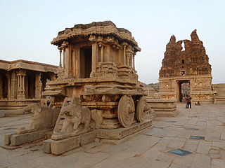
Koppala district, officially known as Koppala district is an administrative district in the state of Karnataka in India. In the past Koppal was referred to as 'Kopana Nagara'. Hampi, a World heritage center, covers some areas of Koppala District. It is situated approximately 38 km away. Anegundi, is also a famous travel destination.
Sindhanur is a city and taluk headquarter of Sindhanur taluk of Raichur District in Karnataka. The river Tungabhadra covers the irrigation area by left bank canal. Most of the land in the field is composed of cultivable black soil. Paddy is cultivated using the Tungabhadra River water. Sindhanur is also known as the Paddy Granary of Raichur. With the availability of Tungabhadra river water, paddy rice is grown twice a year. Sindhanur is the place where the majority of tractor sales take place in Asia. as agricultural activities take place year-round. Sona Masuri and Basmati rice are grown in Sindhanur.Amba Matha also spelled as Amba Mutt is a village near Somalapura in the Sindhanur taluk. Amba Matha is a holy place, Sri Amba Devi Temple is located in the village.
Manvi is a City in the Raichur district of the Indian state of Karnataka. It is the municipal headquarters of the Manvi taluk. Manvi Police Station stood fifth in the list of top 10 best police station across the country.

Koppal is the district headquarters of Koppal district in the Indian state of Karnataka. Koppal is surrounded on three sides by hills. It was known as Kopana Nagara. The town has historical landmarks such as the Koppal Fort, Gavimath, and the Male Mallappa Temple. Historically, Koppal was known as Jaina Kashi, meaning the "Kashi" or most-sacred-place for Jains. It was so named because there were more than 700 Basadis, Jain meditation halls or Prarthana Mandirs. Koppal district was carved out of Raichur district, located in the northern part of Karnataka state, on 1 April 1998.
Gangavathi is a city, municipality and taluk in the Koppal district of the Indian state of Karnataka. It is one of the main commercial hubs in the Kalyana-Karnataka region. It is also the largest city, in terms of area and population, in the Koppal district.
Kampli is a town in the Bellary district, Kampli taluk, in the Indian state of Karnataka. It is a headquarters of Kampli Taluk. The town is situated about 15 km away from Hampi.
Kushtagi is a panchayat town in Koppal district in the Indian state of Karnataka. Kushtagi is a taluk center of Koppal district. This taluk has a population of 353,142 as per the 2021 census estimate. In this taluk, pomegranate fruits are popularly grown.There is a Durga devi temple in heart of the town. To its North lies Ilkal, Gajendragad to the West, Hospet to the South and Sindhanur to the East. Red and black soil can be found in this taluk. A big lake 4kms away from the city is the main source of drinking water is situated in west side and covering the area of more than 300 acres.
Siruguppa is a town and headquarters of the Siruguppa taluk and second largest city in Ballari district after Hospete carved out of Ballari district of Indian state of Karnataka.
Gorebal is a village located 9 km from Sindhanur in the Raichur district of Karnataka state, India. Gorebal is well irrigated with Tunga Bhadra left bank canals 32 and 36.
Roudkunda is a village in the Sindhanur taluk of Raichur district in the southern state of Karnataka, India. Roudkunda is famous for Ranganatha swamy temple. Roudkunda is surrounded by hills and there is an ancient fort on the hill top belonging to 16th century. There are various relics found in the hills that have historical importance. Roudkunda is 18 km south to the taluka headquarters Sindhanur and 5 km from Karnataka State Highway 23. Nearest towns are Siruguppa and Karatagi.
Turvihal, also spelled as Turvihala, This village first name is Gokshir it means Cows milk and is a village in the Sindhanur taluk of Raichur district in the Indian state of Karnataka. . Turvihal lies on Karnataka State Highway 6 connecting Sindhanur-Kushtagi.
Mukkunda is a village in the Sindhanur taluk of the Raichur district in Karnataka, India. It is located on the banks of the Tungabhadra river. Mukkunda has several ancient temples, including the Sri Rama mandir shri dhurgamma temple, the Murari Ranga, and the Baajeshwara. The Tungabhadra river surrounds an Eshwara temple built in Hoysala style during the Sindha dynasty. A Sufi saint, hazrat gadde Khadar Bhasha darga Mukkunda is well known, and many visitors from surrounding village will come to take the blessings of this saint. It is and 27 km from Karnataka State Highway 19. The nearest towns are Siruguppa and Karatagi. Mukkunda is well known for its Krishna temple.
Ginigera is a village in the Koppal taluk of Koppal district in the Indian state of Karnataka. It is 10 kilometres (6.2 mi) from Koppal and lies on National Highway 67. Ginigera is on the railway network and lies on the Guntakal–Hubli line.
Kapagal is a village in the Manvi taluk of Raichur district in the Indian state of Karnataka. Kapagal is well connected by road and it lies on Karnataka State highway 19. Kapagal is 8 km from Manvi and 40 km from District Headquarters Raichur. Nearest major railway station is in Raichur.

The following outline is provided as an overview of and topical guide to Karnataka:
Challur is a village in the Karatagi taluk of Koppal district in the southern state of Karnataka, India. Challur is situated near Karatagi.
Hubballi railway division is one of the three railway divisions under South Western Railway zone of Indian Railways. This railway division was formed on 5 November 1951 and its headquarter is located at Hubballi in the state of Karnataka of India.
The Mahabubnagar-Munirabad section is an under construction railway section project of the Indian Railways. The section falls under the administration of Guntakal of South Central Railway zone and Hubli Railway Division of South Western Railway Zone. This serves as the shortest route to Hyderabad-Hubballi and Hyderabad-Goa routes.
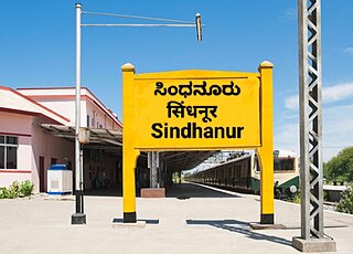
Sindhanur Railway Station falls under Hubli railway division of the South Western Railway in Raichur District, Karnataka, India. Sindhanur railway station has three platforms which serve mainly Sindhanur City and nearby heritage tourist places of historic importance.
