Kashoya-Kitomi Central Forest Reserve

Last updated
Kasyoha-Kitomi Central Forest Reserve
Kashyoha-Kitomi Forest
Uganda relief map.svg
Red pog.svg
Location within Uganda
Location Bushenyi, Ibanda and Kamwenge districts
Nearest city Bushenyi
Coordinates 0°15′58″S30°14′28″E / 0.266°S 30.241°E / -0.266; 30.241
Area433 km2 (167 sq mi)
Established1932
Governing body National Forestry Authority (NFA)

Kasyoha-Kitomi Central Forest Reserve is located in Western Uganda, and has an area of 433-square-kilometre (107,000-acre). It is located south of Lake George and the Kazinga channel in the Albertine Rift eco-region, which is known for its abundance of endemic species. [2] [3] [4] [5] [6] The forest reserve lies within the counties of Bunyaruguru, Igara and Buhweju in the administrative districts of Bushenyi, Ibanda and Kamwenge [2] It was officially gazetted in 1932 and is controlled by Uganda's National Forestry Authority (NFA). [7]

Contents

Setting and structure

Kasyoha-Kitomi is a moist medium-altitude forest with a high concentration of indigenous plants and animals. The elevation ranges from 972 to 2,136 meters above sea level. [7] The majority of the forest reserve is located in the valleys of the western ranges. The annual rainfall is bimodal, ranging from 1250 mm to 1400 mm. [4] [7] The forest reserve, as a critical watershed, provides ecological benefits to Lake George. [8] The forest reserve's western edge borders the Queen Elizabeth National Park and the Kyambula Game Reserve. [9] [10] [11]

Key Biodiversity

The number of bird species recorded from Kasyoha-Kitomi is 308, [12] with over 276 species reported from this forest reserve [13] with the White-napped Pigeon (Columbia albinucha) and Grey Parrot (Psittacus erithacus) considered globally near-threatened. Kasyoha-Kitomi is also home to one Albertine Rift endemic (the Blue-headed Sunbird), Afep Pigeon, Black Bee-eater, Blue-throated Brown Sunbird, Blue-throated Roller, Dusky Long-tailed Cuckoo, White-collared Olive-back, Cinnamon-breasted Bee-eater, Shelley's Greenbul, Equatorial Akalat, and Mountain Illadopsis are among the other species. [7] [14] The reserve is further home to a variety of wildlife species, including habituated chimpazees, red-tailed monkeys, blue monkeys, black and white colobus monkeys, baboons, and vervet monkeys. [15]

Kasyoha-Kitomi exhibit a diversity of wildlife, including one threatened species and one IUCN listed species of mammals. The mammals include among others, the elephant (L. africana), chimpanzee (P. troglodytes) and L’hoest's monkey (C. l’hoesti). [16] The small mammals recorded in Kasyoha-Kitomi include three uncommon forest dependent shrews – Northern Swamp Musk Shrew, Eastern Musk Shrew and Hero Shrew. [13]

Threats

The forest reserve has been deforested in search of arable soil and fuel wood. [4] Because the majority of the larger trees have been harvested for timber and fire wood, the reserve now contains short shrubs and reeds. [7] Since the forest reserve, as a wildlife corridor connects Queen Elizabeth National Park and Kyambula Game Reserve, animal movements along this corridor frequently result in crop attacks on local people's crops. In turn, some communities around the forest reserve have taken advantage of the opportunity to illegally hunt down the animals for meat. [7]

See also

Related Research Articles

<span class="mw-page-title-main">Virunga National Park</span> National park in the Democratic Republic of the Congo

Virunga National Park is a national park in the Albertine Rift Valley in the eastern part of the Democratic Republic of the Congo. It was created in 1925. In elevation, it ranges from 680 m (2,230 ft) in the Semliki River valley to 5,109 m (16,762 ft) in the Rwenzori Mountains. From north to south it extends approximately 300 km (190 mi), largely along the international borders with Uganda and Rwanda in the east. It covers an area of 8,090 km2 (3,120 sq mi).

<span class="mw-page-title-main">Mgahinga Gorilla National Park</span> National Park in Uganda

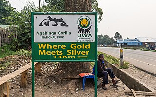
Mgahinga Gorilla National Park is a national park in southwestern Uganda. It was created in 1991 and covers an area of 33.9 km2 (13.1 sq mi).

<span class="mw-page-title-main">Uganda mangabey</span> Species of mammal

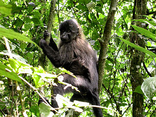
The Uganda mangabey is a species of Old World monkey found only in Uganda and in the Minziro Forest Reserve, just over the border in Tanzania. This crested mangabey was previously thought to just be a population of the grey-cheeked mangabey. Colin Groves upgraded the Ugandan population to the new species L. ugandae on 16 February 2007. This species is significantly smaller than the grey-cheeked mangabey, with a shorter skull and smaller face. 2008 was the most recent year in which the International Union for Conservation of Nature assessed the conservation status of L. albigena, describing it as being of least concern, and the status of L. ugandae has not been assessed separately.

<span class="mw-page-title-main">Mabira Forest</span>

The Mabira Forest is a rainforest area covering about 300 square kilometres (120 sq mi) in Uganda, located in Buikwe District, between Lugazi and Jinja. It has been protected as Mabira Forest Reserve since 1932. It is home for many endangered species like the primate Lophocebus ugandae.

<span class="mw-page-title-main">Kahuzi-Biéga National Park</span> National park in the Democratic Republic of the Congo

The Kahuzi-Biega National Park is a protected area near Bukavu town in eastern Democratic Republic of the Congo. It is situated near the western bank of Lake Kivu and the Rwandan border. Established in 1970 by the Belgian photographer and conservationist Adrien Deschryver, the park is named after two dormant volcanoes, Mount Kahuzi and Mount Biega, which are within its limits. With an area of 6,000 square kilometres (2,300 sq mi), Kahuzi-Biega is one of the biggest national parks in the country. Set in both mountainous and lowland terrain, it is one of the last refuges of the rare species of Eastern lowland gorilla, an endangered category under the IUCN Red List. The park is a UNESCO World Heritage Site, inscribed in 1980 for its unique biodiversity of rainforest habitat and its eastern lowland gorillas. In 1997, it was listed on the List of World Heritage in Danger because of the political instability of the region, an influx of refugees, and increasing wildlife exploitation.

<span class="mw-page-title-main">North Rwenzori Central Forest Reserve</span> Forest reserve

North Rwenzori Central Forest Reserve is a protected tropical forest situated between Bundibugyo District and Ntoroko District in Western Uganda. This Natural Forest Reserve is at the foothills of the Rwenzori Mountains east of the Democratic Republic of Congo.

Rwensambya Central Forest Reserve is a tropical forest located in Kyegegwa district. It covers an area of 671 hectares.

<span class="mw-page-title-main">Kalinzu Central Forest Reserve</span> A protected area in southwestern Uganda.

Kalinzu Central Forest Reserve is a protected area located in Bushenyi district in south-western Uganda. Covering an area of 137 square kilometers, the reserve is characterized by its diverse ecosystem consisting of dense tropical rainforest vegetation and a wide range of wildlife.

Kasyoha-Kitomi Forest Reserve is located in Western Uganda, 35 kilometers from Bushenyi Town, South of Lake George and the Kazinga Channel, and covers an area of 433 square kilometers along the South of Lake George and Kazinga channel in the Albertine region. The reserve is situated in the administrative districts of Bushenyi, Rubirizi, Ibanda and Kamwenge.

Rwengiri Central Forest Reserve is a protected tropical forest that is located in Rukungiri district in Western Uganda. It covers an area of 155 km2. It managed by the National Forestry Authority. Its WPDA ID is 40357. It was designated a reserve in 1968.

Rwengeye Central Forest Reserve is a protected tropical high forest in Kiryanga and Pacwa subcounties that are located in Kibaale District in Western Uganda. It covers an area of 329 hecatres (3.24 km²). It is operated by the National Forestry Authority (NFA). Its WDPA ID is 39999. It was declared a forest reserve in 1932.

Nyabyeya Central Forest Reserve is a forest reserve located in Masindi District, Western Uganda, Bujenje County, Budongo sub-county, and Nyabyeya parish in western Uganda. It is part of the extensive network of Central Forest Reserves managed by the National Forestry Authority (NFA) in Uganda. This forest reserve covers an area of about 358.06 hectares. Nyabyeya Forest Reserve was created to train students in forestry under the Nyabyeya Forestry College.

Nyamakere Central Forest Reserve is a protected area located in the Kiryandongo District of Uganda. It is one of the many Central Forest Reserves managed by the National Forestry Authority (NFA) of Uganda. Nyamakere Central Forest Reserve covers an extensive stretch of over 3.4 kilometers.

Ruzaire Central Forest Reserve is a protected high forest located in Kibaale district which is in the located within the Albertine Region. It covers an area of 1194.94 hectares. It is managed by the National Forestry Authority.

Kagombe Central Forest Reserve is a 301-square-kilometre (74,000-acre) forest reserve located in Western Uganda's district of Kagadi and Nyamarundu sub county. It is also located in Uganda's Albertine Rift ecoregion area renowned for its rich biodiversity.

Muhangi Central Forest Reserve is a protected area located in Western Uganda's Kyenjojo district. Muhangi forest is a closed tropical forest that protects the banks of river Muzizi. It spans an area of 2,044 hectares. It is also located in the Ugandan Albertine Rift, Muzizi River Catchment Area since the River Muzizi runs along the northern part of Muhangi Central Forest Reserve.

Kapchorwa Central Forest Reserve is a forest reserve located in Kapchorwa district found in the eastern part of Uganda at the slopes of Mount Elgon. It is bordered by Mbale, Bulambuli, and Sironko in the south-west, Nakapiripit and Moroto in the north, and the republic of Kenya in the east. The area largely comprises the sabiny, pokot and the nandi communities of western Kenya. The 0.06 square kilometer forest reserve is located at an Altitude of 2,100 to 2,400 meters above sea level.

Kasato Central Forest Reserve is a protected tropical forest that is located in Kiryanga subcounty in Kagadi District in Western Uganda. It covers an area of 26.82 km2(2691 hectares) It managed by the National Forestry Authority. It was designated a reserve in 1965. Its WPDA ID is 39988.

References

  1. Protected Area Profile for Kasyoha - Kitomi Forest Reserve from the World Database on Protected Areas. Retrieved July 27, 2023.
  2. 1 2 Franks, P. (2003). Participatory environmental management: engaging the rural poor as partners in conservation. Copenhagen, CARE Denmark
  3. "Kasyoha – Kitomi Central Forest Reserve". www.nfa.go.ug. Retrieved 2023-05-27.
  4. 1 2 3 Raben, Kim; Nyingi, Johnson; Akello, David Loserian Zerupa; Kidoido, Michael (2007). "Local Stakeholders' Use of Forest Reserves in Kasyoha-Kitomi Forest Landscape, Uganda and Nguru South Forest Landscape, Tanzania" (PDF). www.jstor.org: 10–25. JSTOR   resrep15620.6 . Retrieved 2023-05-27.
  5. "Kashoha-Kitomi Forest Reserve - Forests - Uganda Tourist Sites". 2021-05-26. Retrieved 2023-05-27.
  6. "kasyoha kitomi forest found in Kicuzi Subcounty Ibanda district. Photo by Sylas Byaruhanga | IBANDA DISTRICT". www.ibanda.go.ug. Retrieved 2023-05-27.
  7. 1 2 3 4 5 6 Raben, Kim; Nyingi, Johnson; Akello, David Loserian Zerupa; Kidoido, Michael (2007). "Local stakeholders' use of forest reserves in Kasyoha-Kitomi forest landscape, Uganda and Nguru South forest landscape, Tanzania".{{cite journal}}: Cite journal requires |journal= (help)
  8. PEMA (2003). Participatory environmental management: Engaging the rural poor as partners in conservation.
  9. Bird Life International (2008) Kasyoha-Kitomi Forest Reserve, Birdlife Data Zone. Available at: http://datazone.birdlife.org/index.php/site/factsheet/kasyoha-kitomi-forest-reserve-iba-uganda/text (Accessed: 28 May 2023).
  10. "Kasyoha – Kitomi Forest - Hiking Trails- Birding - Crater Lakes". Kabiza Wilderness Safaris. 2017-01-08. Retrieved 2023-05-27.
  11. Plumptre, Andy (2006-01-01). "Increasing the functionality of the Kyambura-Kasyoha Kitomi corridor and Mpanga Falls area in the Greater Virunga Landscape: management options and cost implications".{{cite journal}}: Cite journal requires |journal= (help)
  12. Plumptre, Andrew J., Tim RB Davenport, Mathias Behangana, Robert Kityo, Gerald Eilu, Paul Ssegawa, Corneille Ewango et al. "The biodiversity of the Albertine Rift." Biological conservation 134, no. 2 (2007): 178-194.
  13. 1 2 Davenport, T. R. B., Howard, P. C., & Baltzer, M. (1996). Mabira forest reserve: Biodiversity inventory report no. 13. Forest Department, Kampala.
  14. "Kasyoha Kitomi Forest Reserve in Queen Elizabeth National Park". Inside Queen Elizabeth National Park. Retrieved 2023-05-27.
  15. "Kasyoha – Kitomi Central Forest Reserve". Prime Uganda Safaris & Tours. Retrieved 2023-05-27.
  16. "Kasyoha-Kitomi Forest Reserve". Africa Safaris | Shanrod Africa. Retrieved 2023-05-27.